

Arbuckle Mountains
Encyclopedia
Mountain range
A mountain range is a single, large mass consisting of a succession of mountains or narrowly spaced mountain ridges, with or without peaks, closely related in position, direction, formation, and age; a component part of a mountain system or of a mountain chain...
in south-central Oklahoma
Oklahoma
Oklahoma is a state located in the South Central region of the United States of America. With an estimated 3,751,351 residents as of the 2010 census and a land area of 68,667 square miles , Oklahoma is the 28th most populous and 20th-largest state...
in the United States
United States
The United States of America is a federal constitutional republic comprising fifty states and a federal district...
. The granite
Granite
Granite is a common and widely occurring type of intrusive, felsic, igneous rock. Granite usually has a medium- to coarse-grained texture. Occasionally some individual crystals are larger than the groundmass, in which case the texture is known as porphyritic. A granitic rock with a porphyritic...
rocks of the Arbuckles date back to the Proterozoic
Proterozoic
The Proterozoic is a geological eon representing a period before the first abundant complex life on Earth. The name Proterozoic comes from the Greek "earlier life"...
Era some 1.4 billion years ago which were overlain by sediments during the Paleozoic
Paleozoic
The Paleozoic era is the earliest of three geologic eras of the Phanerozoic eon, spanning from roughly...
Era. The range reaches a height of 1,412 feet above sea level.
History
They were named indirectly for Gen. Matthew ArbuckleMatthew Arbuckle
Matthew Arbuckle was a career soldier in the U.S. Army closely identified with the Indian Territory for the last thirty years of his life.-Early life:...
(1778–1851), a career soldier from Virginia who was active in the Indian Territory for the last thirty years of his life. Shortly before his death at Fort Smith, Arkansas
Fort Smith, Arkansas
Fort Smith is the second-largest city in Arkansas and one of the two county seats of Sebastian County. With a population of 86,209 in 2010, it is the principal city of the Fort Smith, Arkansas-Oklahoma Metropolitan Statistical Area, a region of 298,592 residents which encompasses the Arkansas...
, from cholera, several detachments of troops under his command had established an outpost to protect the California road, on Wildhorse Creek in present-day Garvin County, Oklahoma
Garvin County, Oklahoma
Garvin County is a county located in the U.S. state of Oklahoma. As of 2000, the population was 27,210. Its county seat is Pauls Valley.-History:...
. The post was then named Fort Arbuckle in his honor. Though the post was abandoned in 1870, the name had already transferred in common usage to the nearby hills.
Geology

Anticline
In structural geology, an anticline is a fold that is convex up and has its oldest beds at its core. The term is not to be confused with antiform, which is a purely descriptive term for any fold that is convex up. Therefore if age relationships In structural geology, an anticline is a fold that is...
structure with an orientation or strike
Strike and dip
Strike and dip refer to the orientation or attitude of a geologic feature. The strike line of a bed, fault, or other planar feature is a line representing the intersection of that feature with a horizontal plane. On a geologic map, this is represented with a short straight line segment oriented...
of west-northwest. The core of the structure consists of Proterozoic
Proterozoic
The Proterozoic is a geological eon representing a period before the first abundant complex life on Earth. The name Proterozoic comes from the Greek "earlier life"...
extrusive and intrusive rocks, the Colbert rhyolite
Rhyolite
This page is about a volcanic rock. For the ghost town see Rhyolite, Nevada, and for the satellite system, see Rhyolite/Aquacade.Rhyolite is an igneous, volcanic rock, of felsic composition . It may have any texture from glassy to aphanitic to porphyritic...
porphyry and the Tishomingo granite
Granite
Granite is a common and widely occurring type of intrusive, felsic, igneous rock. Granite usually has a medium- to coarse-grained texture. Occasionally some individual crystals are larger than the groundmass, in which case the texture is known as porphyritic. A granitic rock with a porphyritic...
(age dated at 1374 Ma), which are overlain and flanked by early Paleozoic limestone
Limestone
Limestone is a sedimentary rock composed largely of the minerals calcite and aragonite, which are different crystal forms of calcium carbonate . Many limestones are composed from skeletal fragments of marine organisms such as coral or foraminifera....
s and sandstone
Sandstone
Sandstone is a sedimentary rock composed mainly of sand-sized minerals or rock grains.Most sandstone is composed of quartz and/or feldspar because these are the most common minerals in the Earth's crust. Like sand, sandstone may be any colour, but the most common colours are tan, brown, yellow,...
s which are very steeply dipping to near vertical in orientation. Pennsylvanian
Pennsylvanian
The Pennsylvanian is, in the ICS geologic timescale, the younger of two subperiods of the Carboniferous Period. It lasted from roughly . As with most other geochronologic units, the rock beds that define the Pennsylvanian are well identified, but the exact date of the start and end are uncertain...
to Permian
Permian
The PermianThe term "Permian" was introduced into geology in 1841 by Sir Sir R. I. Murchison, president of the Geological Society of London, who identified typical strata in extensive Russian explorations undertaken with Edouard de Verneuil; Murchison asserted in 1841 that he named his "Permian...
conglomerate
Conglomerate (geology)
A conglomerate is a rock consisting of individual clasts within a finer-grained matrix that have become cemented together. Conglomerates are sedimentary rocks consisting of rounded fragments and are thus differentiated from breccias, which consist of angular clasts...
s were deposited after the orogenic
Orogeny
Orogeny refers to forces and events leading to a severe structural deformation of the Earth's crust due to the engagement of tectonic plates. Response to such engagement results in the formation of long tracts of highly deformed rock called orogens or orogenic belts...
buckling had uplifted and deformed the older strata
Stratum
In geology and related fields, a stratum is a layer of sedimentary rock or soil with internally consistent characteristics that distinguish it from other layers...
.
The west trending structure of the Arbuckles and the parallel trending Wichita Mountains
Wichita Mountains
The Wichita Mountains are located in the southwestern portion of the U.S. state of Oklahoma. The mountains are a northwest-southeast trending series of rocky promontories, many capped by 540 million-year old granite. These were exposed and rounded by weathering during the Permian Period...
is at almost right angle to the regional tectonic trend of the mid-Paleozoic structure from the Ouachitas
Ouachita Mountains
The Ouachita Mountains are a mountain range in west central Arkansas and southeastern Oklahoma. The range's subterranean roots may extend as far as central Texas, or beyond it to the current location of the Marathon Uplift. Along with the Ozark Mountains, the Ouachita Mountains form the U.S...
south to the Marathon Uplift. The Arbuckles are thought to have originated along a failed rift
Rift
In geology, a rift or chasm is a place where the Earth's crust and lithosphere are being pulled apart and is an example of extensional tectonics....
or aulacogen
Aulacogen
In geology, an aulacogen is a failed arm of a triple junction of a plate tectonics rift system. A triple junction beneath a continental plate initiates a three way breakup of the continental plate. As the continental break-up develops one of the three spreading ridges typically fails or stops...
in the Precambrian basement which was uplifted and folded during the Ouachita Orogeny
Ouachita orogeny
The Ouachita orogeny was a mountain building event that resulted in the folding and faulting of strata currently exposed in the Ouachita Mountains...
.
Hydrology and karst features
Underlying the Arbuckle Mountains is the Arbuckle Simpson aquiferAquifer
An aquifer is a wet underground layer of water-bearing permeable rock or unconsolidated materials from which groundwater can be usefully extracted using a water well. The study of water flow in aquifers and the characterization of aquifers is called hydrogeology...
, housing some of the purest spring water in the world and providing water to the Blue River
Blue River (Oklahoma)
The Blue River is a tributary of the Red River in southern Oklahoma in the United States. Via the Red River, it is part of the watershed of the Mississippi River....
and Honey Creek which flows over Turner Falls south of Davis
Davis, Oklahoma
Davis is a city in Garvin and Murray counties in the U.S. state of Oklahoma. The population was 2,610 at the 2000 census. Davis is the home of the 1979, 1986, 1990, and 1995 Oklahoma State Football Championship teams...
.
As a result of the karst
KARST
Kilometer-square Area Radio Synthesis Telescope is a Chinese telescope project to which FAST is a forerunner. KARST is a set of large spherical reflectors on karst landforms, which are bowlshaped limestone sinkholes named after the Kras region in Slovenia and Northern Italy. It will consist of...
topography
Topography
Topography is the study of Earth's surface shape and features or those ofplanets, moons, and asteroids...
, standing water is rarely found atop the Arbuckle Mountains, the water seeps through the fracture cracks creating elaborate limestone caverns throughout the Arbuckle Mountains. Today the Arbuckles have gradually eroded to their present heights of 300–500 feet above the surrounding terrain or 1300–1400 feet above sea level.
Location and tourism
Carter County, Oklahoma
Carter County is a county located in the U.S. state of Oklahoma. As of 2010, the population was 47,557. Its county seat is Ardmore.Carter County is part of the Ardmore, Oklahoma, Micropolitan Statistical Area.-Geography:According to the U.S...
and southern Murray County
Murray County, Oklahoma
Murray County is a county located in the U.S. state of Oklahoma. As of 2000, the population was 12,623. Its county seat is Sulphur.-Geography:...
, approximately 15 miles (24.1 km) north of Ardmore
Ardmore, Oklahoma
Ardmore is a business, cultural and tourism city in and the county seat of Carter County, Oklahoma, United States. As of the 2010 Census, the city had a population of 24,283, while a 2007 estimate has the Ardmore micropolitan statistical area totaling 56,694 residents...
and 5 miles (8 km) south of Davis, Oklahoma on Interstate 35
Interstate 35
Interstate 35 is a north–south Interstate Highway in the central United States. I-35 stretches from Laredo, Texas, on the U.S.-Mexico border to Duluth, Minnesota, at Minnesota Highway 61 and 26th Avenue East. Many interstates used to have splits or spurs indicated with suffixed letters , but I-35...
. The eastern flank of the ridge is approximately 5 miles (8 km) south of Sulphur
Sulphur, Oklahoma
Sulphur is a city in Murray County, Oklahoma, United States. The population was 4,794 at the 2000 census. It is the county seat of Murray County.-Geography:Sulphur is located at ....
on U.S. Highway 177.
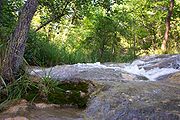
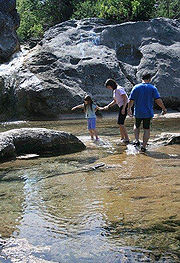
Popular recreation areas in the Arbuckle Mountains include Turner Falls Park
Turner Falls, Oklahoma
Turner Falls, at , is locally considered Oklahoma's tallest waterfall, although its height matches one in Natural Falls State Park. The falls are located on Honey Creek in the Arbuckle Mountains in south central Oklahoma, near the city of Davis.-History:...
, the Chickasaw National Recreation Area
Chickasaw National Recreation Area
Chickasaw National Recreation Areais a National Recreation Area situated in the foothills of the Arbuckle Mountains in south-central Oklahoma near Sulphur.-History:...
, one of the most popular national park facilities in the United States, and Lake of the Arbuckles. Turner Falls is located 5 miles (8 km) south of Davis, whereas Chickasaw NRA is located in the city of Sulphur.
The Arbuckle Mountain area is the proud host of Okla Suave, a one-of-a-kind, annual celebration where families can celebrate their rich traditions and cultures while enjoying beautiful mountain scenery.
The area is also the location of several campgrounds, including the YMCA
YMCA
The Young Men's Christian Association is a worldwide organization of more than 45 million members from 125 national federations affiliated through the World Alliance of YMCAs...
's Camp Classen and the Baptist General Convention of Oklahoma's Falls Creek Baptist Conference Center
Falls Creek Baptist Conference Center
Falls Creek Baptist church camp, also known simply as "Falls Creek", is a conference center and youth camp along Falls Creek in the Arbuckle Mountains of Oklahoma. It is the state's oldest church camp and is also the largest youth encampment in the United States...
, which hosts 55,000 campers each summer.