

Araxá
Encyclopedia
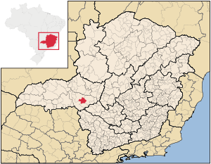

Minas Gerais
Minas Gerais is one of the 26 states of Brazil, of which it is the second most populous, the third richest, and the fourth largest in area. Minas Gerais is the Brazilian state with the largest number of Presidents of Brazil, the current one, Dilma Rousseff, being one of them. The capital is the...
state, Brazil
Brazil
Brazil , officially the Federative Republic of Brazil , is the largest country in South America. It is the world's fifth largest country, both by geographical area and by population with over 192 million people...
. The population was 87,764 inhabitants (2007) and the area of the municipality is 1,283 km², with 345 km² making up the urban perimeter.
Geography
The elevation of the city center is 973 meters. The highest point in the municipality is Serrra da Bocaina with 1,359 meters, and the lowest point is Rio Capivara with 910 meters. In 2004 the annual average temperature was 20.98°C. The annual rainfall was 1,905 mm.Demographics
- Population in 1970: 35,676
- Population in 1980: 53,404
- Population in 1991: 65,911
- Population in 2000: 78,997 (77,743 lived in the urban area)
- Population in 2010: 93,071
Origin of the name
The town was named after the Indian tribe "Araxas" who lived there at the time it was first discovered and the name means "the place from where the sun is seen first".Micro-region
Araxá is a statistical micro-region including 10 municipalities: Araxá, Campos AltosCampos Altos
Campos Altos is a Brazilian municipality located in the west of the state of Minas Gerais. Its population as of 2007 was estimated to be 13,184 people living in a total area of 719 km². The city belongs to the mesoregion of Triângulo Mineiro and Alto Paranaíba and to the micro-region of Araxá. It...
, Ibiá
Ibiá
Ibiá is a Brazilian municipality located in the west of the state of Minas Gerais. Its population as of 2007 was estimated to be 22,069 people living in a total area of 2,707 km². The city belongs to the mesoregion of Triângulo Mineiro and Alto Paranaíba and to the micro-region of Araxá...
, Nova Ponte
Nova Ponte
Nova Ponte is a Brazilian municipality located in the west of the state of Minas Gerais. Its population as of 2007 was estimated to be 11,586 people living in a total area of 1,105 km². The city belongs to the mesoregion of Triângulo Mineiro and Alto Paranaíba and to the micro-region of Araxá...
, Pedrinópolis
Pedrinópolis
Pedrinópolis is a Brazilian municipality located in the west of the state of Minas Gerais. Its population as of 2007 was 3,448 people living in a total area of 357 km². The city belongs to the meso-region of Triângulo Mineiro and Alto Paranaíba and to the micro-region of Araxá...
, Perdizes
Perdizes, Minas Gerais
Perdizes is a Brazilian municipality located in the west of the state of Minas Gerais. Its population as of 2007 was 13,924 people living in a total area of 2,450 km². The city belongs to the meso-region of Triângulo Mineiro and Alto Paranaíba and to the micro-region of Araxá...
, Pratinha
Pratinha
Pratinha is a Brazilian municipality located in the west of the state of Minas Gerais. Its population as of 2007 was 3,236 people living in a total area of 619 km². The city belongs to the meso-region of Triângulo Mineiro and Alto Paranaíba and to the micro-region of Araxá...
, Sacramento
Sacramento, Minas Gerais
Sacramento is a Brazilian municipality located in the west of the state of Minas Gerais. Its population as of 2007 was 22,159 people living in a total area of 3,071 km². The city belongs to the meso-region of Triângulo Mineiro and Alto Paranaíba and to the micro-region of Araxá...
, Santa Juliana
Santa Juliana
Santa Juliana is a Brazilian municipality located in the west of the state of Minas Gerais. Its population as of 2007 was 10,582 people living in a total area of 727 km². The city belongs to the meso-region of Triângulo Mineiro and Alto Paranaíba and to the micro-region of Araxá...
, and Tapira
Tapira, Minas Gerais
Tapira is a Brazilian municipality located in the west of the state of Minas Gerais. Its population as of 2007 was 3,575 people living in a total area of 1,180 km². The city belongs to the meso-region of Triângulo Mineiro and Alto Paranaíba and to the micro-region of Araxá...
. The population of this micro-region was 171,936 (2000) in an area of 14,145.60 km².
Neighboring Municipalities
Neighboring municipalities are PerdizesPerdizes
Perdizes is a district in the subprefecture of Lapa, in São Paulo, Brazil.Built in an ancient area of Pacaembu Farm, Perdizes was historically considered only a poor rural area. Today, it is one of the most urbanized areas of São Paulo and known for being the home for the Pontifical Catholic...
(N and NW), Ibiá
Ibiá
Ibiá is a Brazilian municipality located in the west of the state of Minas Gerais. Its population as of 2007 was estimated to be 22,069 people living in a total area of 2,707 km². The city belongs to the mesoregion of Triângulo Mineiro and Alto Paranaíba and to the micro-region of Araxá...
(E), Tapira (S), and Sacramento
Sacramento, Minas Gerais
Sacramento is a Brazilian municipality located in the west of the state of Minas Gerais. Its population as of 2007 was 22,159 people living in a total area of 3,071 km². The city belongs to the meso-region of Triângulo Mineiro and Alto Paranaíba and to the micro-region of Araxá...
(SW).
Communications
Araxá is served by a good system of federal and state highways that link the municipality to the main economic centers of the country. The highways with access to Araxá are:- BR 452 - Araxá/Uberlândia/Tupaciguara
- BR 262 - Belo Horizonte/Vitória/Corumbá)
- MG 428 - As far as the border of Minas Gerais - São Paulo
Transport
The city is served by the Araxá AirportAraxá Airport
Romeu Zema Airport is the airport serving Araxá, Brazil. It is named after Romeu Zema, a local entrepreneur.-Airlines and destinations:-External links:...
, which has daily flights to Belo Horizonte
Belo Horizonte
Belo Horizonte is the capital of and largest city in the state of Minas Gerais, located in the southeastern region of Brazil. It is the third largest metropolitan area in the country...
, and Uberaba
Uberaba
Uberaba is a city and municipality in the west of the state of Minas Gerais in Brazil. Its population is 296.000 with an area of 4529.7 km², giving a density of 60.71 people per km². It is located on a plateau at an elevation of 785 meters and is in the Uberaba River floodplain...
.
The Ferrovia Centro Atlântica S.A. passes through the city and is limited to cargo transport.
Distances
- Belo HorizonteBelo HorizonteBelo Horizonte is the capital of and largest city in the state of Minas Gerais, located in the southeastern region of Brazil. It is the third largest metropolitan area in the country...
: the state capital is 375 kilometers away - BrasíliaBrasíliaBrasília is the capital city of Brazil. The name is commonly spelled Brasilia in English. The city and its District are located in the Central-West region of the country, along a plateau known as Planalto Central. It has a population of about 2,557,000 as of the 2008 IBGE estimate, making it the...
: 600 km - Rio de JaneiroRio de JaneiroRio de Janeiro , commonly referred to simply as Rio, is the capital city of the State of Rio de Janeiro, the second largest city of Brazil, and the third largest metropolitan area and agglomeration in South America, boasting approximately 6.3 million people within the city proper, making it the 6th...
: 848 km - UberabaUberabaUberaba is a city and municipality in the west of the state of Minas Gerais in Brazil. Its population is 296.000 with an area of 4529.7 km², giving a density of 60.71 people per km². It is located on a plateau at an elevation of 785 meters and is in the Uberaba River floodplain...
: 108 km - São PauloSão PauloSão Paulo is the largest city in Brazil, the largest city in the southern hemisphere and South America, and the world's seventh largest city by population. The metropolis is anchor to the São Paulo metropolitan area, ranked as the second-most populous metropolitan area in the Americas and among...
: 549 km
Economic activities

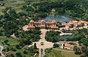
Araxá is famous in Brazil for its spa with medicinal mud and mineral waters. One of Brazil's most emblematic hotels, the Grand Hotel, is the center of attraction. Opened in 1944 by governor Benedito Valadares and President Vargas, the Hotel initiated an era of splendor to Araxa and the inland region of the state and it was the stage for huge social, political and cultural events. The hotel sector has 24 establishments offering 2,708 beds (2004).
One of Brazil's most famous soap operas, "Dona Beja", a mythical character of the city, was filmed here.
In addition to tourism the city has mines of niobium (columbium) used in jet engine components, rocket sub-assemblies, and heat-resisting and combustion equipment. Reserves are about 460 million tons, sufficient to satisfy current world demand for about 500 years. The largest enterprise in this sector is CBMM—Companhia Brasileira de Metallurgia e Mineração.
Araxá is a major producer of phosphate, essential for the production of fertilizers. The most important company in this sector is Bunge Fertilizantes S.A.
The GDP in Brazilian Reais was 1,439,547 billion in 2005. This was generated almost evenly by services and industry. In 2005 there were 2,865 workers in industry, 1,478 in construction, 7,636 in commerce, 1,296 in restaurants and hotels, and 2,691 in public administration. There were 405 rural properties on 68,000 hectares. Around 1,500 persons were employed in agriculture. There were 65,000 head of cattle, most of which was for dairy production. The municipality produced approximately 500,000 liters a day (2004). There is also a large production of poultry and swine. There were 22 producers of cachaça
Cachaça
Cachaça is a liquor made from fermented sugarcane.It is the most popular distilled alcoholic beverage in Brazil. It is also known as aguardente, pinga, caninha and many other names...
, a Brazilian rum, in 2004. The main crops are coffee, corn, and soybeans.
Health and education
In the health sector there were 17 health clinics and 4 hospitals with 244 beds (2005). There were 6 clinical analysis labs and 34 pharmacies. Two of the hospitals are private and 2 are philanthropic. Educational needs of 10,500 students were met by 33 primary schools, 11 middle schoos, and 40 pre-primary schools. In higher education there were 2 schools: Centro Universitário Planalto de Araxá and UNIT – Universidade do Triângulo Mineiro.There was one doctor for every 598 inhabitants (2004) and 3.5 hospital beds for every 1,000 inhabitants. The infant mortality rate was 8.70 deaths for every 1,000 live births (2004), well below the state and national average. In 2000 the number was 20.80.
- Municipal Human Development IndexHuman Development IndexThe Human Development Index is a composite statistic used to rank countries by level of "human development" and separate "very high human development", "high human development", "medium human development", and "low human development" countries...
: 0.799 (2000) - State ranking: 40 out of 853 municipalities as of 2000
- National ranking: 579 out of 5,138 municipalities as of 2000
- Literacy rate: 93%
- Life expectancy: 70 (average of males and females)
In 2000 the per capita monthly income of R$337.00 was above the state and national average of R$276.00 and R$297.00 respectively.
The highest ranking municipality in Minas Gerais in 2000 was Poços de Caldas
Poços de Caldas
Poços de Caldas is a city and municipality in south-western Minas Gerais state, Brazil, in the microregion of the same name. Its estimated population in 2009 was 151,449 inhabitants...
with 0.841, while the lowest was Setubinha
Setubinha
Setubinha is a municipality in the northeast of the Brazilian state of Minas Gerais. As of 2007 the population was 10,834 in a total area of 536 km². The elevation is 729 metres. It is part of the IBGE statistical microregion of Teófilo Otoni...
with 0.568. Nationally the highest was São Caetano do Sul
São Caetano do Sul
São Caetano do Sul is a city in São Paulo state in Brazil, located in the Greater São Paulo Metropolitan Area. It is the city with the highest per capita income in Brazil and it also has the highest Human Development Index .-Geography:São Caetano do Sul is located on a plateau that is part of the...
in São Paulo with 0.919, while the lowest was Setubinha. In more recent statistics (considering 5,507 municipalities) Manari in the state of Pernambuco
Pernambuco
Pernambuco is a state of Brazil, located in the Northeast region of the country. To the north are the states of Paraíba and Ceará, to the west is Piauí, to the south are Alagoas and Bahia, and to the east is the Atlantic Ocean. There are about of beaches, some of the most beautiful in the...
has the lowest rating in the country—0,467—putting it in last place.