

Appalachian Trail by state
Encyclopedia
The Appalachian National Scenic Trail spans fourteen U.S. states during its journey that is 2179 miles (3,506.8 km) long, including Georgia
, North Carolina
, Tennessee
, Virginia
, West Virginia
, Maryland
, Pennsylvania
, New Jersey
, New York
, Connecticut
, Massachusetts
, Vermont
, New Hampshire
, and Maine
. It begins at Springer Mountain
, Georgia
, and follows the ridgeline of the Appalachian Mountains
, crossing many of its highest peaks and running with only a few exceptions almost continuously through wilderness
before ending at Mount Katahdin
, Maine
.
The trail is currently protected along more than 99% of its course by federal or state land ownership or right-of-way
. Annually, more than 4,000 volunteers contribute over 175,000 hours to maintain the trail, an effort coordinated largely by the Appalachian Trail Conservancy
(ATC), assisted by some thirty trail clubs and multiple partnerships.
→ Union County
→ Lumpkin County
→ White County
→ Towns County
→ Habersham County
→ Rabun County
 Georgia has 76.4 miles (120 km) of the trail, including the southern terminus at Springer Mountain
(elevation 3280 feet (999.7 m), 992 m). An 8.8 mile (12 km) approach trail (not part of the AT) begins at the Amicalola Falls State Park
visitor center. The approach trail is often littered with items cast aside by overburdened hikers unprepared for the difficulties of the initial hike. At 4,461 feet (1,360 m), Blood Mountain
is the highest point on the trail in Georgia. The AT and approach trail are managed and maintained by the Georgia Appalachian Trail Club
.
→ Macon County
→ Swain County
→ Graham County
→ Swain County
→ (The following counties are traversed along the Tennessee border) Haywood County
→ Madison County
→ Yancey County
→ Mitchell County
→ Avery County
North Carolina has 88 miles (142 km) of the trail, not including more than 200 miles (325 km) along the Tennessee border. Altitude ranges from 1,725 to 5,498 feet (525 to 1,676 m).
The trail crosses Bly Gap one-tenth of a mile north of the Georgia state line. The trail further north includes peaks such as Standing Indian Mountain
, Mount Albert
, and Wayah Bald
, followed by a Nantahala Gorge crossing by Wesser Falls and at Nantahala Outdoor Center, and, at the section's north end, is the Fontana Dam Shelter, affectionately known as the Fontana Hilton, known for its view of fjordlike Fontana Lake
, comparatively spacious accommodations, water spigots, flush toilets, nearby free hot showers and a one dollar shuttle to an all-you-can-eat buffet. It is also a short distance from a post-office, making it an ideal re-loading location.
→ Sevier County
→ Cocke County → Greene County → Unicoi County → Carter County
(where it leaves the North Carolina border) → Johnson County → Sullivan County
 Tennessee has 293 miles (472 km) of the trail, including more than 200 miles (325 km) along or near the North Carolina border. The section that runs just below the summit of Clingmans Dome
in Great Smoky Mountains National Park
is the highest point on the trail at 6,625 feet (2,019 m). The trail enters Tennessee from North Carolina atop Doe Knob, on the crest of the Smokies, and exits Tennessee into Virginia atop Holston Mountain
.
The first 64 miles (103 km) of the A.T. in Tennessee follows the crest of the Smokies, and is largely shared with North Carolina. In the western Smokies, the trail traverses a young forest that replaced what was once a large highland pasture, most noticeable in areas such as Spence Field
, Thunderhead Mountain
, and Silers Bald
. The trail reaches 6000 feet (1,828.8 m) for the first time on the western slope of Mount Buckley (a sub-peak of Clingmans Dome), where it first enters the sub-alpine spruce-fir forest
, and comes within a few meters of the summit of Clingmans. The trail crosses US-441 at Newfound Gap
and traverses a series of rocky cliffs known as "The Sawteeth" en route to the high ridges of the Eastern Smokies. Here, the trail crosses Mount Chapman
and Mount Guyot
, and passes one of its most remote shelters at Tricorner Knob
before gradually descending.
Just beyond Mount Cammerer
, the A.T. exits the Smokies, crossing I-40
into the Cherokee National Forest
. After traversing Snowbird Mountain, Max Patch
Bald, and Lemon Gap (just south of Del Rio
), the trail exits Tennessee atop Bluff Mountain and re-enters again atop Rich Mountain (in Greene County), some 10 miles (16 km) to the northeast.
After traversing the Bald Mountains
, the Appalachian Trail crosses the Nolichucky River
and enters the Unakas, gradually ascending to the Roan Highlands
near the town of Roan Mountain
in Carter County
. Atop Roan High Knob, the A.T. again eclipses 6,000 feet (approximately 6,280 feet), and passes the highest shelter along the entire trail. After crossing Grassy Ridge, which is the longest stretch of grassy bald
in the Appalachians, the trail descends to the Laurel Fork Valley, where it turns west away from the state boundary.
Just beyond White Rocks Mountain, the trail passes through Hampton, Tennessee before turning north again. At Watauga Lake
at the TVA Watauga Dam
, the trail turns northeast, crossing Iron Mountain before turning briefly to the northwest at the Carter County
-Johnson County line. After passing over Cross Mountain, the trail again turns northeast and ascends Holston Mountain en route to Virginia.
→ Smyth County
→ Grayson County
→ Wythe County
→ Bland County
→ Tazewell County
→ Giles County
Briefly joins the West Virginia
border here → Craig County
→ Montgomery County
→ Roanoke County
→ Botetourt County
→ Bedford County
→ Rockbridge County
→ Amherst County
→ Nelson County
→ Augusta County
→ Albemarle County
→ Rockingham County
→ Greene County
→ Page County
→ Rappahannock County
→ Warren County
→ Fauquier County
→ Clarke County
→ (rejoins the West Virginia Border here) Loudoun County
 Virginia has the most mileage of the trail of any state (more than a quarter) with 550 miles (885 km) of the trail, including about 20 miles (32 km) along the West Virginia border. Some consider the Virginia section to be the wettest, most challenging part of the hike for northbound hikers. Substantial portions closely parallel the Blue Ridge Parkway
and, farther north in Shenandoah National Park
, the Skyline Drive
.
McAfee Knob is affectionately known as "the most photographed spot on the A.T."
The plant life on Virginia's section of the trail includes thickly-growing wild blueberry bushes. The bushes are especially numerous along the trail's central sections, through the Shenandoah National Park, and its northern sections. The blueberries ripen in late summer, offering hikers a plentifully available food source.
The annual "Trail Days" festival held in Damascus, Virginia
has become the largest single gathering of Appalachian Trail hikers anywhere.
(while sharing the trail with Virginia in the south → Jefferson County
(while sharing the trail and briefly entering the state.)
West Virginia has 4 miles (6 km) of the trail, not including about 20 miles (32 km) along the Virginia border. The trail passes through the town of Harpers Ferry, headquarters of the Appalachian Trail Conservancy
. Harpers Ferry is considered the "psychological midpoint" of the AT.
→ Frederick County
Maryland has 41 miles (66 km) of the trail, ranging in elevation from 230 to 1,880 feet (70–570 m) Hikers are required to stay at designated shelters and campsites, no camping off-trail. Some hikers choose to hike Maryland in a single day, usually starting just before dawn and ending at dusk. This is known as the Maryland Challenge. The Challenge is especially popular among thru-hikers due to the endurance built up by the time one reaches Maryland from either terminus. A variation of this challenge is known as the Four State Challenge involves hiking between the ridge line straddling Virginia and West Virginia all the way to or from Pennsylvania in 24 hours, thus hiking in four states in one day. The Four State Challenge requires a hike of approximately 45 miles, most of which are in Maryland.
→ Cumberland County
→ Perry County
→ Dauphin County
→ Lebanon County
→ Schuylkill County
→ Berks County
→ Lehigh County
→ Carbon County
→ Northampton County
→ Monroe County
Pennsylvania has 229 miles (369 km) of the trail The trail extends from the Pennsylvania-Maryland border at Pen Mar, a tiny town straddling the state line, to the Delaware Water Gap
, at the Pennsylvania-New Jersey line. The Susquehanna River
is generally considered the dividing line between the northern and southern sections of the Pennsylvania AT. The AT crosses the Susquehanna via the Clarks Ferry Bridge
, near Duncannon
.
In the southern half of the state, the AT passes through Caledonia State Park
, Michaux State Forest
, and Pine Grove Furnace State Park
(the actual midpoint of the AT is near PGF State Park). These areas in south central Pennsylvania are the northernmost portions of the Blue Ridge Mountains, which are geologically distinct from the Ridge and Valley section further north. The two parts are separated by the broad Cumberland Valley
, where the trail has a change of scenery, crossing many farms and large highways. There is no camping allowed in the 18 miles (29 km) stretch between Alec Kennedy and Darlington shelters.
In the northern half of the state, the AT climbs back up into the mountains and passes through St. Anthony's Wilderness, which is the second largest roadless area in Pennsylvania and home to several coal mining ghost towns, such as Yellow Springs
and Rausch Gap
.
Trail towns that are popular stops with thru-hikers are Boiling Springs
, Duncannon
, Port Clinton
, Palmerton
, Wind Gap
, and Delaware Water Gap
.
Northwest of the Schuylkill River
, the trail runs along the top of the Blue Mountain
ridge. Just before entering New Jersey, the Blue Mountain ridge becomes the Kittatinny Ridge
.
With the description of "where boots go to die", Pennsylvania is infamous among thru-hikers for having more long stretches of rocky trail than any other state, although many feel the rocks are overrated. The worst rocks are in the northern half of the state, north of the Susquehanna River. Many consider Pennsylvania one of these easier parts of the AT, since it is mostly walking on ridges with relatively small elevation changes compared to many other states.
In 1984, the ad-hoc citizen's group Citizens Against the New Trail (CANT) and four local townships organized to oppose suggested changes by The National Park Service (NPS) to the sixteen-mile route in the Great Cumberland Valley between Carlisle and Harrisburg, the longest route that follows a paved highway.
→ Sussex County
→ Passaic County

 New Jersey is home to 72 miles (116 km) of the trail. This makes the New Jersey section of the Appalachian Trail the second longest trail in the state, behind the Delaware and Raritan Canal Trail. More than half of the Appalachian Trail is along the top of Kittatinny Ridge at the northwestern corner of the state. The trail enters New Jersey from the south on a pedestrian walkway along the Interstate 80
Delaware Water Gap Toll Bridge
over the Delaware River
, ascends from the Delaware Water Gap to the top of Kittatinny Ridge in Worthington State Forest
, passes Sunfish Pond
, continues through Stokes State Forest
, and eventually reaches High Point State Park
, highest peak in New Jersey (a side trail is required to reach the actual peak). It then turns in a southeastern direction along the New York-New Jersey border for about 30 miles (48 km), passing over long sections of boardwalk bridges over marshy land, then entering Wawayanda State Park
and then the Abraham Hewitt State Forest just before entering New York near Greenwood Lake
.
Black bear activity along the trail in New Jersey increased rapidly starting in 2001. In July 2005, a teenage hiker sleeping at Mashipacong Shelter was awakened by a bear biting his leg. The bear was later identified and killed by authorities (New Jersey Herald or this more complete account). Metal bear-proof trash boxes are in place at all New Jersey shelters.
→ Rockland County
→ Westchester County
→ Putnam County
→ Dutchess County
 New York's 88 miles (142 km) of trail contain very little elevation change compared to other states. It is rather rugged terrain nonetheless, with many short though nearly-vertical ledges and small cliffs. From south to north, the trail summits many small mountains under 1,400 feet (430 m) in elevation, its highest point in New York being Prospect Rock at 1,433 feet (438 m), and less than half a mile (800 m) from the border with New Jersey. The trail continues north, climbing near Fitzgerald Falls, passing through Sterling Forest State Park
, and then entering Harriman State Park and Bear Mountain State Park
. In Harriman State Park, the trail passes through the famous Lemon Squeezer
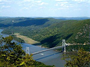
, a narrow crack between huge boulders. It crosses the Hudson River
on the Bear Mountain Bridge
, which is the lowest point on the entire Appalachian Trail at 124 feet (38 m). It then passes through Fahnestock State Park and continues northeast and crosses the Metro-North Railroad
's Harlem Line at Pawling
, which is also the only train station
along the length of the trail. It enters Connecticut via the Pawling Nature Reserve. The section of the trail that passes through Harriman and Bear Mountain State Park
s is the oldest section of the trail, completed in 1923.
Professional trail builder Eddie Walsh and Edward Goodell (Executive Director of the New York-New Jersey Trail Conference) oversaw and coordinated the construction of a paved trail coming off of Bear Mountain. That portion of the Trail is composed of 800 steps made of 1,000-pound slabs of granite followed by over a mile of walkway supported by stone crib walls with boulders called gargoyles lining the path. The project took four years, cost roughly $1 million, and was executed by about 700 volunteers. It officially opened in June 2010.
→ Fairfield County
The 53 miles (84 km) of trail in Connecticut lie almost entirely along the ridge
s to the west above the Housatonic River
Valley. The trail climbs ridges below the town of Kent, and then works its way past the Housatonic River to Falls Village, where it regains the heights. After the town of Salisbury, the trail ascends into the Taconic Range, in order: Lions Head, Riga Ridge, and Bear Mountain, after which the Massachusetts line is achieved at Sage's Ravine.
The trail passes within one mile (1.6 km) of the business district of Kent
, a popular resupply point for long-distance hikers. In the town of Salisbury
(which occupies the northwestern corner of the state), it skirts the town center before reaching the summit of Bear Mountain
, the highest peak in Connecticut at 2,326 feet (709 m), descending, and entering Massachusetts. (The state's highest point, on the shoulder of Mount Frissell
at the Massachusetts line, lies about 2 miles (3 km) off the AT, just east of the junction of those two states with New York. Such a side-trip is on the order of 5 miles (8 km) long and entails about 1,300 vertical feet (400 m) of climbing.)
 Massachusetts has 90 miles (145 km) of trail. The entire section of trail is in western Massachusetts' Berkshire County; it traverses both the Taconic Mountains
and the Berkshires. The A.T. climbs the highest peak in the southern Taconic Mountains, Mount Everett
(2,602 feet, 793 m), then descends to the Housatonic River
Valley and skirts the town of Great Barrington
. From there, it ascends into the Berkshire Mountains and passes through the towns of Dalton
and Cheshire
. It ascends into the Taconic Mountains again, visiting the highest point in the state at 3,491 feet (1064 m), Mount Greylock
. It then quickly descends to the valley within 2 miles (3 km) of North Adams
and Williamstown
, before ascending again to the Vermont state line. The trail throughout Massachusetts is maintained by the Berkshire Chapter of the Appalachian Mountain Club.
→Rutland County →Bennington County
Vermont has 150 miles (241 km) of the trail. Upon entering Vermont, the trail coincides with the southernmost sections of the generally north/south-oriented Long Trail
(which is subject to a request by its maintainers to protect it in its most vulnerable part of the year by forgoing spring hiking). It follows the ridge of the southern Green Mountains, summiting such notable peaks as Stratton Mountain
, Glastenbury Mountain
and Killington Peak
. The trail traverses the Glastenbury
, Lye Brook
, and Peru Peak Wilderness areas. After parting ways with the Long Trail at Maine Junction, the AT turns in a more eastward direction, crossing the White River
, passing through Norwich
, and entering Hanover, New Hampshire
, as it crosses the Connecticut River
. In Vermont, The Green Mountain Club
maintains the AT from the Massachusetts state border to Route 12
. The Dartmouth Outing Club
maintains the trail from Route 12 to the New Hampshire state line.
The NPS challenged Killington and Pico ski resorts in Vermont over development of private land that crossed the AT.
→Carroll County
→Grafton County
 New Hampshire has 161 miles (259 km) of the trail. The New Hampshire AT is nearly all within the White Mountain National Forest
. The easier southern portion of the trail, from Hanover
to Glencliff
, passes over Velvet Rocks, Moose Mountain
, Smarts Mountain
, and Mount Cube. It then ascends Mount Moosilauke and enters the high peaks region of the Whites
. For northbound thru-hikers, it is the beginning of the main challenges that go beyond enduring distance and time: in New Hampshire and Maine, rough or steep ground are more frequent, and alpine
conditions are found near summits and along ridges.
The trail runs completely above treeline from the summit of Mount Pierce
to the north side of the cone of Mt. Madison
, a distance of about 12 miles (19.3 km). The AT passes over the summits of 16 of the 48 four-thousand footers
of New Hampshire: Moosilauke, South and North Kinsman
, Lincoln
, Lafayette, Garfield
, South Twin
, Jackson
, Pierce, Washington
(the highest point of the AT north of Tennessee), Madison, Wildcats D and A
, Carter Dome, South
and Middle Carter
. It comes close to the summits of 8 other of the 48 four-thousand footers
: Liberty
, Galehead
, Zealand
, Eisenhower
, Monroe
, Jefferson
, Adams
, and Moriah
. A series of comfortable huts
is maintained along parts of the NH trail by the Appalachian Mountain Club
. In New Hampshire, the Dartmouth Outing Club
maintains the AT from the Vermont border to Mount Moosilauke, with the AMC maintaining the remaining miles through the state. The trail passes through the towns of Hanover and Gorham
, which have grocery stores and are accessible by public transportation (Dartmouth Coach and Concord Trailways) from Boston
. Concord Trailways also has bus service to Lincoln
(several miles off the AT) and AMC Pinkham Notch
. During the summer season, AMC runs a shuttle service to Crawford Notch
and Franconia Notch
.
A tradition of thru-hikers Mooning the Cog
has developed on Mount Washington
.
→ Somerset County
→ Franklin County
→ Oxford County
The Appalachian Trail Conservancy
(or ATC) believes the 281 miles (452 km) of the trail in Maine are particularly difficult. The western section includes a mile-long (1.6 km) stretch of boulders at Mahoosuc Notch
, often called the trail's hardest mile. The central Maine section crosses of the Kennebec River
at a point where it is 200 feet (65 m) wide, the widest unbridged stream along the trail. The last and most isolated portion in the state (and arguably on the entire trail) is known as the "100-Mile Wilderness
." This section heads east-northeast from the town of Monson
and ends outside Baxter State Park
just south of Abol Bridge. More moose
are seen by hikers in this state than any other on the trail. The northern terminus of the Appalachian Trail is on Katahdin's Baxter Peak in Baxter State Park
.
Baxter State Park
closes the summer rules overnight camping season from October 15 to May 15 each year. Park management strongly discourages thru-hiking within the park before May 31 or after October 15. The AMC maintains the AT from the New Hampshire border to Grafton Notch, with the Maine Appalachian Trail Club responsible for maintaining the remaining miles to Katahdin.
Beginning in the late 1980s, The NPS and ATC challenged the Saddleback Mountain resort in Maine over development of private land that crossed the AT. The dispute continued a decade later, and after a June 1996 meeting between the two sides, NPS and ATC relented from some of their previous positions and reduced their proposed land-acquisition corridor by 70 percent. Even so, they remained opposed to any ski trails crossing the Trail in the alpine area. Saddleback responded that further negotiations were unnecessary and the NPS began appraising if the area was feasible for development.
Georgia (U.S. state)
Georgia is a state located in the southeastern United States. It was established in 1732, the last of the original Thirteen Colonies. The state is named after King George II of Great Britain. Georgia was the fourth state to ratify the United States Constitution, on January 2, 1788...
, North Carolina
North Carolina
North Carolina is a state located in the southeastern United States. The state borders South Carolina and Georgia to the south, Tennessee to the west and Virginia to the north. North Carolina contains 100 counties. Its capital is Raleigh, and its largest city is Charlotte...
, Tennessee
Tennessee
Tennessee is a U.S. state located in the Southeastern United States. It has a population of 6,346,105, making it the nation's 17th-largest state by population, and covers , making it the 36th-largest by total land area...
, Virginia
Virginia
The Commonwealth of Virginia , is a U.S. state on the Atlantic Coast of the Southern United States. Virginia is nicknamed the "Old Dominion" and sometimes the "Mother of Presidents" after the eight U.S. presidents born there...
, West Virginia
West Virginia
West Virginia is a state in the Appalachian and Southeastern regions of the United States, bordered by Virginia to the southeast, Kentucky to the southwest, Ohio to the northwest, Pennsylvania to the northeast and Maryland to the east...
, Maryland
Maryland
Maryland is a U.S. state located in the Mid Atlantic region of the United States, bordering Virginia, West Virginia, and the District of Columbia to its south and west; Pennsylvania to its north; and Delaware to its east...
, Pennsylvania
Pennsylvania
The Commonwealth of Pennsylvania is a U.S. state that is located in the Northeastern and Mid-Atlantic regions of the United States. The state borders Delaware and Maryland to the south, West Virginia to the southwest, Ohio to the west, New York and Ontario, Canada, to the north, and New Jersey to...
, New Jersey
New Jersey
New Jersey is a state in the Northeastern and Middle Atlantic regions of the United States. , its population was 8,791,894. It is bordered on the north and east by the state of New York, on the southeast and south by the Atlantic Ocean, on the west by Pennsylvania and on the southwest by Delaware...
, New York
New York
New York is a state in the Northeastern region of the United States. It is the nation's third most populous state. New York is bordered by New Jersey and Pennsylvania to the south, and by Connecticut, Massachusetts and Vermont to the east...
, Connecticut
Connecticut
Connecticut is a state in the New England region of the northeastern United States. It is bordered by Rhode Island to the east, Massachusetts to the north, and the state of New York to the west and the south .Connecticut is named for the Connecticut River, the major U.S. river that approximately...
, Massachusetts
Massachusetts
The Commonwealth of Massachusetts is a state in the New England region of the northeastern United States of America. It is bordered by Rhode Island and Connecticut to the south, New York to the west, and Vermont and New Hampshire to the north; at its east lies the Atlantic Ocean. As of the 2010...
, Vermont
Vermont
Vermont is a state in the New England region of the northeastern United States of America. The state ranks 43rd in land area, , and 45th in total area. Its population according to the 2010 census, 630,337, is the second smallest in the country, larger only than Wyoming. It is the only New England...
, New Hampshire
New Hampshire
New Hampshire is a state in the New England region of the northeastern United States of America. The state was named after the southern English county of Hampshire. It is bordered by Massachusetts to the south, Vermont to the west, Maine and the Atlantic Ocean to the east, and the Canadian...
, and Maine
Maine
Maine is a state in the New England region of the northeastern United States, bordered by the Atlantic Ocean to the east and south, New Hampshire to the west, and the Canadian provinces of Quebec to the northwest and New Brunswick to the northeast. Maine is both the northernmost and easternmost...
. It begins at Springer Mountain
Springer Mountain
Springer Mountain is located in the Chattahoochee National Forest in Fannin County of northern Georgia. It is now the southern terminus of the Appalachian Trail.-Geography:The mountain's peak is at above mean sea level.-Appalachian Trail:...
, Georgia
Georgia (U.S. state)
Georgia is a state located in the southeastern United States. It was established in 1732, the last of the original Thirteen Colonies. The state is named after King George II of Great Britain. Georgia was the fourth state to ratify the United States Constitution, on January 2, 1788...
, and follows the ridgeline of the Appalachian Mountains
Appalachian Mountains
The Appalachian Mountains #Whether the stressed vowel is or ,#Whether the "ch" is pronounced as a fricative or an affricate , and#Whether the final vowel is the monophthong or the diphthong .), often called the Appalachians, are a system of mountains in eastern North America. The Appalachians...
, crossing many of its highest peaks and running with only a few exceptions almost continuously through wilderness
Wilderness
Wilderness or wildland is a natural environment on Earth that has not been significantly modified by human activity. It may also be defined as: "The most intact, undisturbed wild natural areas left on our planet—those last truly wild places that humans do not control and have not developed with...
before ending at Mount Katahdin
Mount Katahdin
Mount Katahdin is the highest mountain in Maine at . Named Katahdin by the Penobscot Indians, the term means "The Greatest Mountain". Katahdin is the centerpiece of Baxter State Park: a steep, tall mountain formed from underground magma. The flora and fauna on the mountain are typical of those...
, Maine
Maine
Maine is a state in the New England region of the northeastern United States, bordered by the Atlantic Ocean to the east and south, New Hampshire to the west, and the Canadian provinces of Quebec to the northwest and New Brunswick to the northeast. Maine is both the northernmost and easternmost...
.
The trail is currently protected along more than 99% of its course by federal or state land ownership or right-of-way
Easement
An easement is a certain right to use the real property of another without possessing it.Easements are helpful for providing pathways across two or more pieces of property or allowing an individual to fish in a privately owned pond...
. Annually, more than 4,000 volunteers contribute over 175,000 hours to maintain the trail, an effort coordinated largely by the Appalachian Trail Conservancy
Appalachian Trail Conservancy
The Appalachian Trail Conservancy is a nonprofit organization dedicated to the conservation of the Appalachian Trail, which runs from Maine to Georgia...
(ATC), assisted by some thirty trail clubs and multiple partnerships.
Georgia
Counties crossed: Fannin CountyFannin County, Georgia
Fannin County is a county located in the U.S. state of Georgia. It was created on January 21, 1854. As of 2000, the population was 19,798. The 2007 Census Estimate shows a population of 22,580...
→ Union County
Union County, Georgia
Union County is a county located in the U.S. state of Georgia. As of 2000, the population was 17,289. The 2007 Census Estimate shows a population of 20,968. The county seat is Blairsville.Its Sole commissioner is Lamar Paris, who has served since 2001....
→ Lumpkin County
Lumpkin County, Georgia
Lumpkin County is a county located in the U.S. state of Georgia. As of the 2010 census, the population was 29,966. Its county seat is Dahlonega.- History :...
→ White County
White County, Georgia
White County is a county located in the northeast corner of the U.S. state of Georgia. It was created on December 22, 1857, from part of Habersham County. The county was named for Newton County Representative David T. White, who helped a Habersham representative successfully attain passage of an...
→ Towns County
Towns County, Georgia
Towns County is a county located in the U.S. state of Georgia. It was created on March 6, 1856. As of the 2000 census, the population was 9,319. The 2007 Census Estimate shows a population of 10,894. Its county seat is Hiawassee.-History:...
→ Habersham County
Habersham County, Georgia
Habersham County is a county located in the U.S. state of Georgia. It was created on December 15, 1818, and named for Colonel Joseph Habersham. As of 2000, the population was 35,902. The 2007 Census Estimate shows a population of 42,272. Clarkesville is the county seat.Chartered in 1823, the...
→ Rabun County
Rabun County, Georgia
Rabun County is a county located in the U.S. state of Georgia. As of the 2000 census, the population was 15,050. The 2007 Census Estimate shows a population of 16,519...
Springer Mountain
Springer Mountain is located in the Chattahoochee National Forest in Fannin County of northern Georgia. It is now the southern terminus of the Appalachian Trail.-Geography:The mountain's peak is at above mean sea level.-Appalachian Trail:...
(elevation 3280 feet (999.7 m), 992 m). An 8.8 mile (12 km) approach trail (not part of the AT) begins at the Amicalola Falls State Park
Amicalola Falls State Park
Amicalola Falls State Park is an 829 acre Georgia state park located between Ellijay and Dahlonega in Dawsonville, Georgia. The park's name is derived from a Cherokee language word meaning "tumbling waters". The park is home to Amicalola Falls, a 729-foot waterfall, making it the highest in...
visitor center. The approach trail is often littered with items cast aside by overburdened hikers unprepared for the difficulties of the initial hike. At 4,461 feet (1,360 m), Blood Mountain
Blood Mountain
Blood Mountain is the highest peak on the Georgia section of the Appalachian Trail and the sixth-tallest mountain in Georgia, with an elevation of . It is located on the border of Lumpkin County with Union County and is within the boundaries of the Chattahoochee National Forest and the Blood...
is the highest point on the trail in Georgia. The AT and approach trail are managed and maintained by the Georgia Appalachian Trail Club
Georgia Appalachian Trail Club
The Georgia Appalachian Trail Club, Inc. is a non-profit organization that was organized in 1930 in Dahlonega, GA. Its membership consists of individual volunteers who share a love for the Appalachian Trail ....
.
- See: Georgia Peaks on the Appalachian Trail
North Carolina
Counties crossed: Clay CountyClay County, North Carolina
-Communities and Townships:Hayesville, with a 2000 population of 297, is the only incorporated town in the county, the county seat, and center of economic activity for Clay County...
→ Macon County
Macon County, North Carolina
- Geographic features :Of the in Macon County, are federal lands that lie within the Nantahala National Forest and are administered by the United States Forest Service. Of the of USFS land, lie in the Highlands Ranger District and the remaining lie in the Wayah Ranger District...
→ Swain County
Swain County, North Carolina
Swain County is a county located in the U.S. state of North Carolina. As of 2000, the population was 12,968. Its county seat is Bryson City.Swain County is home of the Nantahala River . The Nantahala is one of the most popular whitewater rafting rivers in the nation...
→ Graham County
Graham County, North Carolina
-Demographics:As of the census of 2000, there were 7,993 people, 3,354 households, and 2,411 families residing in the county. The population density was 27 people per square mile . There were 5,084 housing units at an average density of 17 per square mile...
→ Swain County
Swain County, North Carolina
Swain County is a county located in the U.S. state of North Carolina. As of 2000, the population was 12,968. Its county seat is Bryson City.Swain County is home of the Nantahala River . The Nantahala is one of the most popular whitewater rafting rivers in the nation...
→ (The following counties are traversed along the Tennessee border) Haywood County
Haywood County, North Carolina
-National protected areas:* Blue Ridge Parkway * Great Smoky Mountains National Park * Pisgah National Forest -Major Highways & Roads:* Interstate 40* U.S. Highway 19* U.S. Highway 23* U.S. Highway 74* U.S...
→ Madison County
Madison County, North Carolina
-Demographics:As of the census of 2000, there were 19,635 people, 8,000 households, and 5,592 families residing in the county. The population density was 44 people per square mile . There were 9,722 housing units at an average density of 22 per square mile...
→ Yancey County
Yancey County, North Carolina
-Demographics:As of the census of 2000, there were 17,774 people, 7,472 households, and 5,372 families residing in the county. The population density was 57 people per square mile . There were 9,729 housing units at an average density of 31 per square mile...
→ Mitchell County
Mitchell County, North Carolina
-National protected areas:* Blue Ridge Parkway * Pisgah National Forest -Demographics:As of the census of 2000, there were 15,687 people, 6,551 households, and 4,736 families residing in the county. The population density was 71 people per square mile . There were 7,919 housing units at an...
→ Avery County
Avery County, North Carolina
- Climate :As a result of its relatively high elevation, Avery County has a Humid continental climate enjoying considerably cooler summers than most of the rest of the Eastern US. Likewise, winters are longer, colder and snowier than most other locations in the region. This can be evidenced by the...
North Carolina has 88 miles (142 km) of the trail, not including more than 200 miles (325 km) along the Tennessee border. Altitude ranges from 1,725 to 5,498 feet (525 to 1,676 m).
The trail crosses Bly Gap one-tenth of a mile north of the Georgia state line. The trail further north includes peaks such as Standing Indian Mountain
Standing Indian Mountain
Standing Indian Mountain, elevation 5,499 feet, is part of the North Carolina portion of the Southern Nantahala Wilderness within the boundaries of the Nantahala National Forest...
, Mount Albert
Mount Albert (North Carolina)
Mount Albert is a mountain in North Carolina's Nantahala Range of the Appalachian Mountains. The Appalachian Trail goes along its summit, which is high. A fire tower offers views of the Blue Ridge and the Little Tennessee River valley....
, and Wayah Bald
Wayah Bald
Wayah Bald is a high-altitude treeless open area in Nantahala National Forest, near Franklin, North Carolina. The Wayah Bald Observation Tower is located at the area's highest point ; the stone observation tower was built by the Civilian Conservation Corps in 1937 for fire detection.The...
, followed by a Nantahala Gorge crossing by Wesser Falls and at Nantahala Outdoor Center, and, at the section's north end, is the Fontana Dam Shelter, affectionately known as the Fontana Hilton, known for its view of fjordlike Fontana Lake
Fontana Lake
Fontana Lake is a reservoir impounded by Fontana Dam on the Little Tennessee River located in Graham and Swain counties in North Carolina. The lake forms part of the southern border of Great Smoky Mountains National Park and the northern border of part of the Nantahala National Forest. Depending on...
, comparatively spacious accommodations, water spigots, flush toilets, nearby free hot showers and a one dollar shuttle to an all-you-can-eat buffet. It is also a short distance from a post-office, making it an ideal re-loading location.
Tennessee
Counties crossed: Blount CountyBlount County, Tennessee
Blount County is a U.S. county located in the U.S. state of Tennessee. Its population was 123,010 at the United States Census, 2010. The county seat is at Maryville, which is also the county's largest city....
→ Sevier County
Sevier County, Tennessee
Sevier County is a county of the state of Tennessee, United States. Its population was 71,170 at the 2000 United States Census. It is included in the Sevierville, Tennessee, Micropolitan Statistical Area, which is included in the Knoxville-Sevierville-La Follette, TN Combined Statistical Area. The...
→ Cocke County → Greene County → Unicoi County → Carter County
Carter County, Tennessee
Carter County is a county located in the U.S. state of Tennessee. As of 2010, the population was 57,424. Its county seat is Elizabethton.Carter County is part of the Johnson City Metropolitan Statistical Area, which is a component of the Johnson City–Kingsport–Bristol, TN-VA Combined...
(where it leaves the North Carolina border) → Johnson County → Sullivan County
Clingmans Dome
Clingmans Dome is a mountain in the Great Smoky Mountains of Tennessee and North Carolina, in the southeastern United States. At an elevation of , it is the highest mountain in the Smokies, the highest point in the state of Tennessee, and the highest point along the Appalachian Trail...
in Great Smoky Mountains National Park
Great Smoky Mountains National Park
Great Smoky Mountains National Park is a United States National Park and UNESCO World Heritage Site that straddles the ridgeline of the Great Smoky Mountains, part of the Blue Ridge Mountains, which are a division of the larger Appalachian Mountain chain. The border between Tennessee and North...
is the highest point on the trail at 6,625 feet (2,019 m). The trail enters Tennessee from North Carolina atop Doe Knob, on the crest of the Smokies, and exits Tennessee into Virginia atop Holston Mountain
Holston Mountain
Holston Mountain is a mountain ridge in Upper East Tennessee and southwest Virginia, in the United States. It is in the Blue Ridge Mountains part of the Appalachian Mountains...
.
The first 64 miles (103 km) of the A.T. in Tennessee follows the crest of the Smokies, and is largely shared with North Carolina. In the western Smokies, the trail traverses a young forest that replaced what was once a large highland pasture, most noticeable in areas such as Spence Field
Spence Field
Spence Field is a highland meadow in the Great Smoky Mountains, located inthe Southeastern United States. It has an elevation of 4,920 feet above sea level...
, Thunderhead Mountain
Thunderhead Mountain
Thunderhead Mountain is a mountain in the west-central part of the Great Smoky Mountains, located in the Southeastern United States. Rising along the border between Tennessee and North Carolina, the mountain dominates the Western Smokies. The Appalachian Trail crosses its summit, making it a...
, and Silers Bald
Silers Bald
Silers Bald is a mountain in the western Great Smoky Mountains, located in theSoutheastern United States. Its proximity to Clingmans Dome and its location alongthe Appalachian Trail make it a popular hiking destination....
. The trail reaches 6000 feet (1,828.8 m) for the first time on the western slope of Mount Buckley (a sub-peak of Clingmans Dome), where it first enters the sub-alpine spruce-fir forest
Southern Appalachian spruce-fir forest
The Southern Appalachian spruce-fir forest is a type of montane coniferous forest that grows in the highest elevations in the southern Appalachian Mountains of the eastern United States...
, and comes within a few meters of the summit of Clingmans. The trail crosses US-441 at Newfound Gap
Newfound Gap
Newfound Gap is a mountain pass located near the center of the Great Smoky Mountains National Park of the southern Appalachian Mountains in the United States of America. Situated along the border of Tennessee and North Carolina, the state line crosses the gap, as does U.S...
and traverses a series of rocky cliffs known as "The Sawteeth" en route to the high ridges of the Eastern Smokies. Here, the trail crosses Mount Chapman
Mount Chapman
Mount Chapman is a mountain in the Great Smoky Mountains, located in the Southeastern United States. It has an elevation of 6,417 feet above sea level. While the mountain is located deep within the Great Smokies, the Appalachian Trail crosses its eastern slope, coming to within of the summit...
and Mount Guyot
Mount Guyot (Great Smoky Mountains)
Mount Guyot is a mountain in the eastern Great Smoky Mountains, located inthe southeastern United States. At above sea level, Guyot is the fourth-highestsummit in the eastern U.S., and the second-highest in the Great Smoky Mountains National Park...
, and passes one of its most remote shelters at Tricorner Knob
Tricorner Knob
Tricorner Knob is a mountain in the Great Smoky Mountains, located in the Southeastern United States. It has an elevation of 6,120 feet , with 160 feet of clean prominence. The Appalachian Trail and Balsam Mountain Trail intersect near the mountain's summit, making Tricorner Knob the great...
before gradually descending.
Just beyond Mount Cammerer
Mount Cammerer
Mount Cammerer is a mountain on the northeastern fringe of the Great Smoky Mountains, in the Southeastern United States. The mountain is situated on the state line between Cocke County, Tennessee and Haywood County, North Carolina...
, the A.T. exits the Smokies, crossing I-40
Interstate 40
Interstate 40 is the third-longest major east–west Interstate Highway in the United States, after I-90 and I-80. Its western end is at Interstate 15 in Barstow, California; its eastern end is at a concurrency of U.S. Route 117 and North Carolina Highway 132 in Wilmington, North Carolina...
into the Cherokee National Forest
Cherokee National Forest
The Cherokee National Forest is a large National Forest created on July 19, 1936, by U.S. President Franklin Roosevelt, operated by the U.S. Forest Service and encompassing some 640,000 acres .-Location:...
. After traversing Snowbird Mountain, Max Patch
Max Patch
Max Patch is a bald mountain on the North Carolina-Tennessee Border in Madison County, North Carolina and Cocke County, Tennessee. It is a major landmark along the Tennessee/North Carolina section of the Appalachian Trail, although its summit is located in North Carolina...
Bald, and Lemon Gap (just south of Del Rio
Del Rio, Tennessee
Del Rio is an unincorporated community in Cocke County, Tennessee, United States. Although it is not a census-designated place, the ZIP Code Tabulation Area for the ZIP Code that serves Del Rio had a population of 2,138, according to the 2000 census....
), the trail exits Tennessee atop Bluff Mountain and re-enters again atop Rich Mountain (in Greene County), some 10 miles (16 km) to the northeast.
After traversing the Bald Mountains
Bald Mountains
The Bald Mountains are a mountain range rising along the border between Tennessee and North Carolina in the southeastern United States. They are part of the Blue Ridge Mountain Province of the Southern Appalachian Mountains...
, the Appalachian Trail crosses the Nolichucky River
Nolichucky River
The Nolichucky River is a major stream draining the Blue Ridge Mountains of western North Carolina and east Tennessee. The river is long.-Hydrography:...
and enters the Unakas, gradually ascending to the Roan Highlands
Roan Mountain (Roan Highlands)
Roan Mountain is the highpoint of the Roan-Unaka Range of the Southern Appalachian Mountains, located in the Southeastern United States. The mountain is clad in a dense stand of Southern Appalachian spruce-fir forest, and includes the world's largest natural rhododendron garden, and the longest...
near the town of Roan Mountain
Roan Mountain, Tennessee
Roan Mountain is a census-designated place in Carter County, Tennessee, United States. The population was 1,360 at the 2010 census. It is part of the Johnson City Metropolitan Statistical Area, which is a component of the Johnson City–Kingsport–Bristol, TN-VA Combined Statistical Area...
in Carter County
Carter County, Tennessee
Carter County is a county located in the U.S. state of Tennessee. As of 2010, the population was 57,424. Its county seat is Elizabethton.Carter County is part of the Johnson City Metropolitan Statistical Area, which is a component of the Johnson City–Kingsport–Bristol, TN-VA Combined...
. Atop Roan High Knob, the A.T. again eclipses 6,000 feet (approximately 6,280 feet), and passes the highest shelter along the entire trail. After crossing Grassy Ridge, which is the longest stretch of grassy bald
Appalachian balds
In the Appalachian Mountains of the eastern United States, balds are mountain summits or crests covered primarily by thick vegetation of native grasses or shrubs occurring in areas where heavy forest growth would be expected....
in the Appalachians, the trail descends to the Laurel Fork Valley, where it turns west away from the state boundary.
Just beyond White Rocks Mountain, the trail passes through Hampton, Tennessee before turning north again. At Watauga Lake
Watauga Lake
Watauga Lake, located southeast of Elizabethton, Tennessee, was created by the Tennessee Valley Authority with the completion of the TVA Watauga Dam and Reservoir....
at the TVA Watauga Dam
Watauga Dam
Watauga Dam is a hydroelectric and flood control dam on the Watauga River in Carter County, in the U.S. state of Tennessee. It is owned and operated by the Tennessee Valley Authority, which built the dam in the 1940s as part of efforts to control flooding in the Tennessee River watershed...
, the trail turns northeast, crossing Iron Mountain before turning briefly to the northwest at the Carter County
Carter County, Tennessee
Carter County is a county located in the U.S. state of Tennessee. As of 2010, the population was 57,424. Its county seat is Elizabethton.Carter County is part of the Johnson City Metropolitan Statistical Area, which is a component of the Johnson City–Kingsport–Bristol, TN-VA Combined...
-Johnson County line. After passing over Cross Mountain, the trail again turns northeast and ascends Holston Mountain en route to Virginia.
Virginia
Counties crossed: Washington CountyWashington County, Virginia
As of the census of 2000, there were 51,103 people, 21,056 households, and 14,949 families residing in the county. The population density was 91 people per square mile . There were 22,985 housing units at an average density of 41 per square mile...
→ Smyth County
Smyth County, Virginia
As of the census of 2000, there were 33,081 people, 13,493 households, and 9,607 families residing in the county. The population density was 73 people per square mile . There were 15,111 housing units at an average density of 33 per square mile...
→ Grayson County
Grayson County, Virginia
As of the census of 2000, there were 17,917 people, 7,259 households, and 5,088 families residing in the county. The population density was 40 people per square mile . There were 9,123 housing units at an average density of 21 per square mile...
→ Wythe County
Wythe County, Virginia
As of the census of 2000, there were 27,599 people, 11,511 households, and 8,103 families residing in the county. The population density was 60 people per square mile . There were 12,744 housing units at an average density of 28 per square mile...
→ Bland County
Bland County, Virginia
As of the census of 2000, there were 6,871 people, 2,568 households, and 1,908 families residing in the county. The population density was 19 people per square mile . There were 3,161 housing units at an average density of 9 per square mile...
→ Tazewell County
Tazewell County, Virginia
As of the census of 2000, there were 44,598 people, 18,277 households and 13,232 families residing in the county. The population density was 86 people per square mile . There were 20,390 housing units at an average density of 39 per square mile...
→ Giles County
Giles County, Virginia
As of the census of 2000, there were 16,657 people, 6,994 households, and 4,888 families residing in the county. The population density was 47 people per square mile . There were 7,732 housing units at an average density of 22 per square mile...
Briefly joins the West Virginia
West Virginia
West Virginia is a state in the Appalachian and Southeastern regions of the United States, bordered by Virginia to the southeast, Kentucky to the southwest, Ohio to the northwest, Pennsylvania to the northeast and Maryland to the east...
border here → Craig County
Craig County, Virginia
As of the census of 2000, there were 5,091 people, 2,060 households, and 1,507 families residing in the county. The population density was 15 people per square mile . There were 2,554 housing units at an average density of 8 per square mile...
→ Montgomery County
Montgomery County, Virginia
As of the census of 2000, there were 83,629 people, 30,997 households, and 17,203 families residing in the county. The population density was 215 people per square mile . There were 32,527 housing units at an average density of 84 per square mile...
→ Roanoke County
Roanoke County, Virginia
Roanoke County is a county located in the U.S. state of the Commonwealth of Virginia. It is part of the Roanoke Metropolitan Statistical Area and located within the Roanoke Region of Virginia. As of the 2000 census, the population was 85,778. As of 2010, the population was 92,376...
→ Botetourt County
Botetourt County, Virginia
As of the census of 2000, there were 30,496 people, 11,700 households, and 9,114 families residing in the county. The population density was 56 people per square mile . There were 12,571 housing units at an average density of 23 per square mile...
→ Bedford County
Bedford County, Virginia
As of the census of 2000, there were 60,371 people, 23,838 households, and 18,164 families residing in the county. The population density was 80 people per square mile . There were 26,841 housing units at an average density of 36 per square mile...
→ Rockbridge County
Rockbridge County, Virginia
As of the census of 2000, there were 20,808 people, 8,486 households, and 6,075 families residing in the county. The population density was 35 people per square mile . There were 9,550 housing units at an average density of 16 per square mile...
→ Amherst County
Amherst County, Virginia
As of the census of 2000, there were 31,894 people, 11,941 households, and 8,645 families residing in the county. The population density was 67 people per square mile . There were 12,958 housing units at an average density of 27 per square mile...
→ Nelson County
Nelson County, Virginia
As of the census of 2000, there were 14,445 people, 5,887 households, and 4,144 families residing in the county. The population density was 31 people per square mile . There were 8,554 housing units at an average density of 18 per square mile...
→ Augusta County
Augusta County, Virginia
As of the census of 2000, there were 65,615 people, 24,818 households, and 18,911 families residing in the county. The population density was 68 people per square mile . There were 26,738 housing units at an average density of 28 per square mile...
→ Albemarle County
Albemarle County, Virginia
As of the census of 2000, there were 79,236 people, 31,876 households, and 21,070 families residing in the county. The population density was 110 people per square mile . There were 33,720 housing units at an average density of 47 per square mile...
→ Rockingham County
Rockingham County, Virginia
As of the census of 2000, there were 67,725 people, 25,355 households, and 18,889 families residing in the county. The population density was 80 people per square mile . There were 27,328 housing units at an average density of 32 per square mile...
→ Greene County
Greene County, Virginia
As of the census of 2000, there are 15,244 people, 5,574 households, and 4,291 families residing in the county. The population density is 97 people per square mile . There are 5,986 housing units at an average density of 38 per square mile...
→ Page County
Page County, Virginia
As of the census of 2000, there were 23,177 people, 9,305 households, and 6,634 families residing in the county. The population density was 74 people per square mile . There were 10,557 housing units at an average density of 34 per square mile...
→ Rappahannock County
Rappahannock County, Virginia
As of the census of 2010, there were 7,373 people, 2,788 households, and 2,004 families residing in the county. The population density was 26 people per square mile . There were 3,303 housing units at an average density of 12 per square mile...
→ Warren County
Warren County, Virginia
As of the census of 2000, there were 31,584 people, 12,087 households, and 8,521 families residing in the county. The population density was 148 people per square mile . There were 13,299 housing units at an average density of 62 per square mile...
→ Fauquier County
Fauquier County, Virginia
As of the census of 2000, there were 55,139 people, 19,842 households, and 15,139 families residing in the county. The population density was 85 people per square mile . There were 21,046 housing units at an average density of 32 per square mile...
→ Clarke County
Clarke County, Virginia
Clarke County is a county in the Commonwealth of Virginia. As of 2010, the population was 14,034. Its county seat is Berryville.-History:Clarke County was established in 1836 by Thomas Fairfax, 6th Lord Fairfax of Cameron who built a home, Greenway Court, on part of his 5 million acre property,...
→ (rejoins the West Virginia Border here) Loudoun County
Loudoun County, Virginia
Loudoun County is a county located in the Commonwealth of Virginia, and is part of the Washington Metropolitan Area. As of the 2010 U.S. Census, the county is estimated to be home to 312,311 people, an 84 percent increase over the 2000 figure of 169,599. That increase makes the county the fourth...
Blue Ridge Parkway
The Blue Ridge Parkway is a National Parkway and All-American Road in the United States, noted for its scenic beauty. It runs for 469 miles , mostly along the famous Blue Ridge, a major mountain chain that is part of the Appalachian Mountains...
and, farther north in Shenandoah National Park
Shenandoah National Park
Shenandoah National Park encompasses part of the Blue Ridge Mountains in the U.S. state of Virginia. This national park is long and narrow, with the broad Shenandoah River and valley on the west side, and the rolling hills of the Virginia Piedmont on the east...
, the Skyline Drive
Skyline Drive
Skyline Drive is a 105-mile road that runs the entire length of the National Park Service's Shenandoah National Park in the Blue Ridge Mountains of Virginia, generally along the ridge of the mountains. The scenic drive is particularly popular in the fall when the leaves are changing colors...
.
McAfee Knob is affectionately known as "the most photographed spot on the A.T."
The plant life on Virginia's section of the trail includes thickly-growing wild blueberry bushes. The bushes are especially numerous along the trail's central sections, through the Shenandoah National Park, and its northern sections. The blueberries ripen in late summer, offering hikers a plentifully available food source.
The annual "Trail Days" festival held in Damascus, Virginia
Damascus, Virginia
Damascus is a town in Washington County, Virginia, United States. The population was 981 at the 2000 census. It is part of the Kingsport–Bristol –Bristol Metropolitan Statistical Area, which is a component of the Johnson City–Kingsport–Bristol, TN-VA Combined Statistical...
has become the largest single gathering of Appalachian Trail hikers anywhere.
West Virginia
Counties crossed: Monroe CountyMonroe County, West Virginia
As of the census of 2000, there were 14,583 people, 5,447 households, and 3,883 families residing in the county. The population density was 31 people per square mile . There were 7,267 housing units at an average density of 15 per square mile...
(while sharing the trail with Virginia in the south → Jefferson County
Jefferson County, West Virginia
Jefferson County is a county located in the U.S. state of West Virginia. As of 2010, the population was 53,498. Its county seat is Charles Town...
(while sharing the trail and briefly entering the state.)
West Virginia has 4 miles (6 km) of the trail, not including about 20 miles (32 km) along the Virginia border. The trail passes through the town of Harpers Ferry, headquarters of the Appalachian Trail Conservancy
Appalachian Trail Conservancy
The Appalachian Trail Conservancy is a nonprofit organization dedicated to the conservation of the Appalachian Trail, which runs from Maine to Georgia...
. Harpers Ferry is considered the "psychological midpoint" of the AT.
Maryland
Counties crossed: Washington CountyWashington County, Maryland
Washington County is a county located in the western part of the U.S. state of Maryland, bordering southern Pennsylvania to the north, northern Virginia to the south, and the Eastern Panhandle of West Virginia to the south and west. As of the 2010 Census, its population is 147,430...
→ Frederick County
Frederick County, Maryland
Frederick County is a county located in the western part of the U.S. state of Maryland, bordering the southern border of Pennsylvania and the northeastern border of Virginia. As of the 2010 Census, the population was 233,385....
Maryland has 41 miles (66 km) of the trail, ranging in elevation from 230 to 1,880 feet (70–570 m) Hikers are required to stay at designated shelters and campsites, no camping off-trail. Some hikers choose to hike Maryland in a single day, usually starting just before dawn and ending at dusk. This is known as the Maryland Challenge. The Challenge is especially popular among thru-hikers due to the endurance built up by the time one reaches Maryland from either terminus. A variation of this challenge is known as the Four State Challenge involves hiking between the ridge line straddling Virginia and West Virginia all the way to or from Pennsylvania in 24 hours, thus hiking in four states in one day. The Four State Challenge requires a hike of approximately 45 miles, most of which are in Maryland.
Pennsylvania
Counties crossed: Franklin CountyFranklin County, Pennsylvania
As of the census of 2000, there were 129,313 people, 50,633 households, and 36,405 families residing in the county. The population density was 168 people per square mile . There were 53,803 housing units at an average density of 70 per square mile...
→ Cumberland County
Cumberland County, Pennsylvania
Cumberland County is a county located in the U.S. state of Pennsylvania and is one of three counties comprising the Harrisburg–Carlisle Metropolitan Statistical Area. As of 2010, the population was 235,406.-History:...
→ Perry County
Perry County, Pennsylvania
As of the census of 2000, there were 43,602 people, 16,695 households, and 12,320 families residing in the county. The population density was 79 people per square mile . There were 18,941 housing units at an average density of 34 per square mile...
→ Dauphin County
Dauphin County, Pennsylvania
Dauphin County is a county in the U.S. state of Pennsylvania and is one of the three counties comprising the Harrisburg–Carlisle Metropolitan Statistical Area. As of 2010 census, the population was 268,100. The county includes the city of Harrisburg, which has served as the state capital...
→ Lebanon County
Lebanon County, Pennsylvania
As of the census of 2000, there were 120,327 people and 32,771 families residing in the county. The population density was 332 people per square mile . There were 49,320 housing units at an average density of 136 per square mile...
→ Schuylkill County
Schuylkill County, Pennsylvania
-Notable people:*Boxing heavyweight great Muhammad Ali had his training camp in Deer Lake.*Charles Justin Bailey, commanding general of the 81st Division in World War I, was born in Tamaqua on June 21, 1859....
→ Berks County
Berks County, Pennsylvania
-Demographics:As of the census of 2000, there were 373,638 people, 141,570 households, and 98,532 families residing in the county. The population density was 435 people per square mile . There were 150,222 housing units at an average density of 175 per square mile...
→ Lehigh County
Lehigh County, Pennsylvania
-Climate:Most of the county's climate is considered to fall in the humid continental climate zone. Summers are typically hot and muggy, fall and spring are generally mild, and winter is cold. Precipitation is almost uniformly distributed throughout the year....
→ Carbon County
Carbon County, Pennsylvania
As of the census of 2000, there were 58,802 people, 23,701 households, and 16,424 families residing in the county. The population density was 154 people per square mile . There were 30,492 housing units at an average density of 80 per square mile...
→ Northampton County
Northampton County, Pennsylvania
As of the 2010 census, the county was 86.3% White, 5.0% Black or African American, 0.2% Native American or Alaskan Native, 2.4% Asian, 0.0% Native Hawaiian, 2.2% were two or more races, and 3.8% were some other race. 10.5% of the population were of Hispanic or Latino ancestry.As of the census of...
→ Monroe County
Monroe County, Pennsylvania
-National protected areas:* Delaware Water Gap National Recreation Area * Middle Delaware National Scenic River -Demographics:As of the census of 2010, there are 176,567 people, 49,454 households, and 36,447 families residing in the county. The population density was 228 people per square mile...
Pennsylvania has 229 miles (369 km) of the trail The trail extends from the Pennsylvania-Maryland border at Pen Mar, a tiny town straddling the state line, to the Delaware Water Gap
Delaware Water Gap
The Delaware Water Gap is on the border of New Jersey and Pennsylvania where the Delaware River cuts through a large ridge of the Appalachian Mountains...
, at the Pennsylvania-New Jersey line. The Susquehanna River
Susquehanna River
The Susquehanna River is a river located in the northeastern United States. At long, it is the longest river on the American east coast that drains into the Atlantic Ocean, and with its watershed it is the 16th largest river in the United States, and the longest river in the continental United...
is generally considered the dividing line between the northern and southern sections of the Pennsylvania AT. The AT crosses the Susquehanna via the Clarks Ferry Bridge
Clarks Ferry Bridge
The Clarks Ferry Bridge, carries U.S. Routes 22 and 322 across the Susquehanna River near Duncannon, Pennsylvania about 20 miles north of Harrisburg, Pennsylvania. It is a 4 lane expressway standard bridge. The bridge also provides safe passage for hikers, bikers, and pedestrians using the...
, near Duncannon
Duncannon, Pennsylvania
Duncannon is a borough in Perry County, Pennsylvania, United States. The population was 1,508 at the 2000 census. It is part of the Harrisburg–Carlisle Metropolitan Statistical Area. The center of population of Pennsylvania is located in Duncannon. It is named after the coastal town of...
.
In the southern half of the state, the AT passes through Caledonia State Park
Caledonia State Park
Caledonia State Park is a Pennsylvania state park in Greene Township, Franklin County and Franklin Township, Adams County in Pennsylvania in the United States. The park is named for an iron furnace, Caledonia Furnace, that was owned by Thaddeus Stevens beginning in 1837. Today the park is known...
, Michaux State Forest
Michaux State Forest
Michaux State Forest is a Pennsylvania State Forest in Pennsylvania Bureau of Forestry District #1. The main offices are located in Fayetteville in Franklin County, Pennsylvania in the United States....
, and Pine Grove Furnace State Park
Pine Grove Furnace State Park
Pine Grove Furnace State Park is a protected Pennsylvania area that includes Laurel and Fuller lakes in Cooke Township. The park provides various outdoor recreation activities, has the remains of the Pine Grove Iron Works, and was the site of the 1830 Laurel Forge, 1880s Pine Grove Park, and an...
(the actual midpoint of the AT is near PGF State Park). These areas in south central Pennsylvania are the northernmost portions of the Blue Ridge Mountains, which are geologically distinct from the Ridge and Valley section further north. The two parts are separated by the broad Cumberland Valley
Cumberland Valley
The Cumberland Valley is a constituent valley of the Great Appalachian Valley and a North American agricultural region within the Atlantic Seaboard watershed in Pennsylvania and Maryland....
, where the trail has a change of scenery, crossing many farms and large highways. There is no camping allowed in the 18 miles (29 km) stretch between Alec Kennedy and Darlington shelters.
In the northern half of the state, the AT climbs back up into the mountains and passes through St. Anthony's Wilderness, which is the second largest roadless area in Pennsylvania and home to several coal mining ghost towns, such as Yellow Springs
Yellow Springs, Pennsylvania
Yellow Springs is a historic village and ghost town in West Pikeland Township, Chester County, Pennsylvania, United States, between Phoenixville and Downingtown. The community includes historic churches, established in the 1770s by German Reformed and Lutheran members. The village is located on a...
and Rausch Gap
Rausch Gap, Pennsylvania
The ghost town of Rausch Gap was the largest of several coal mining towns in St. Anthony's Wilderness that appeared, flourished, and died during the period between 1830 and 1910...
.
Trail towns that are popular stops with thru-hikers are Boiling Springs
Boiling Springs, Pennsylvania
Boiling Springs is a census-designated place in South Middleton Township, Cumberland County, Pennsylvania, United States, and is part of the Harrisburg metropolitan area...
, Duncannon
Duncannon, Pennsylvania
Duncannon is a borough in Perry County, Pennsylvania, United States. The population was 1,508 at the 2000 census. It is part of the Harrisburg–Carlisle Metropolitan Statistical Area. The center of population of Pennsylvania is located in Duncannon. It is named after the coastal town of...
, Port Clinton
Port Clinton, Pennsylvania
Port Clinton is a borough in Schuylkill County, Pennsylvania, United States. The population was 288 at the 2000 census.-Geography:Port Clinton is located at ....
, Palmerton
Palmerton, Pennsylvania
Palmerton is a borough in Carbon County, Pennsylvania, United States. It is located in the coal region of the state. It is a part of lower Carbon County, which is considered part of the Lehigh Valley and the greater Allentown Metropolitan Area....
, Wind Gap
Wind Gap, Pennsylvania
Wind Gap is a borough in Northampton County, Pennsylvania, United States. Wind Gap is located in the Lehigh Valley region of the state. It is part of Pennsylvania's Slate Belt .The population of Wind Gap was 2,720 at the 2010 census.-Geography:...
, and Delaware Water Gap
Delaware Water Gap, Pennsylvania
Delaware Water Gap is a borough in Monroe County, Pennsylvania, United States. It is located adjacent to the Delaware Water Gap, the pass through which the Lackawanna Corridor and Interstate 80 run across the Pennsylvania-New Jersey border along the Delaware River.The population of Delaware Water...
.
Northwest of the Schuylkill River
Schuylkill River
The Schuylkill River is a river in Pennsylvania. It is a designated Pennsylvania Scenic River.The river is about long. Its watershed of about lies entirely within the state of Pennsylvania. The source of its eastern branch is in the Appalachian Mountains at Tuscarora Springs, near Tamaqua in...
, the trail runs along the top of the Blue Mountain
Blue Mountain (Pennsylvania)
Blue Mountain is a ridge that forms the eastern edge of the Appalachian mountain range in the U.S. state of Pennsylvania. It cuts across the eastern half of the state from New Jersey to Maryland, providing a distinct boundary between a number of Pennsylvania's geographical and cultural regions...
ridge. Just before entering New Jersey, the Blue Mountain ridge becomes the Kittatinny Ridge
Kittatinny Mountains
The Kittatinny Mountains are a long ridge traversing across northwestern New Jersey running in a northeast-southwest axis. It is the first major ridge in the far northeastern extension of the Ridge and Valley province of the Appalachian Mountains...
.
With the description of "where boots go to die", Pennsylvania is infamous among thru-hikers for having more long stretches of rocky trail than any other state, although many feel the rocks are overrated. The worst rocks are in the northern half of the state, north of the Susquehanna River. Many consider Pennsylvania one of these easier parts of the AT, since it is mostly walking on ridges with relatively small elevation changes compared to many other states.
In 1984, the ad-hoc citizen's group Citizens Against the New Trail (CANT) and four local townships organized to oppose suggested changes by The National Park Service (NPS) to the sixteen-mile route in the Great Cumberland Valley between Carlisle and Harrisburg, the longest route that follows a paved highway.
New Jersey
Counties crossed: Warren CountyWarren County, New Jersey
Warren County is a county located in the U.S. state of New Jersey. As of the 2010 Census, the population was 108,692. Its county seat is Belvidere...
→ Sussex County
Sussex County, New Jersey
The County of Sussex is the northernmost county in the State of New Jersey. It is part of the New York City Metropolitan Area. As of the 2010 Federal decennial census, 149,265 persons resided in Sussex County...
→ Passaic County
Passaic County, New Jersey
Passaic County is a county located in the U.S. state of New Jersey. As of the 2010 Census, the population was 501,226. Its county seat is Paterson...
Interstate 80
Interstate 80 is the second-longest Interstate Highway in the United States, following Interstate 90. It is a transcontinental artery running from downtown San Francisco, California to Teaneck, New Jersey in the New York City Metropolitan Area...
Delaware Water Gap Toll Bridge
Delaware Water Gap Toll Bridge
The Delaware Water Gap Toll Bridge is a toll bridge that carries I-80 across the Delaware River at the Delaware Water Gap, connecting Hardwick Township, New Jersey and Delaware Water Gap, Pennsylvania. The bridge was built by the Delaware River Joint Toll Bridge Commission...
over the Delaware River
Delaware River
The Delaware River is a major river on the Atlantic coast of the United States.A Dutch expedition led by Henry Hudson in 1609 first mapped the river. The river was christened the South River in the New Netherland colony that followed, in contrast to the North River, as the Hudson River was then...
, ascends from the Delaware Water Gap to the top of Kittatinny Ridge in Worthington State Forest
Worthington State Forest
The 6,421 acre Worthington State Forest runs more than seven miles along the Kittatinny Ridge in Columbia, in Warren County, on the New Jersey side of the Delaware River, just north of the Delaware Water Gap in the Delaware Water Gap National Recreation Area. The park offers hiking, camping and...
, passes Sunfish Pond
Sunfish Pond
Sunfish Pond is a glacial lake surrounded by a hardwood forest located on the Kittatinny Ridge within Worthington State Forest, adjacent to the Delaware Water Gap National Recreation Area in Warren County, New Jersey. The Appalachian Trail runs alongside the western and northern edges of the...
, continues through Stokes State Forest
Stokes State Forest
Stokes State Forest is a state park located in Sandyston Township, Montague and Frankford Twp. in Sussex County, New Jersey, United States. Stokes comprises of mountainous woods...
, and eventually reaches High Point State Park
High Point
High Point, in the northwestern part of New Jersey in Montague, Sussex County in the Skylands Region of New Jersey, is the highest elevation in the state at 1,803 feet . It is southeast of Port Jervis, New York. High Point is the highest peak of the Kittatinny Mountains.At the peak is the High...
, highest peak in New Jersey (a side trail is required to reach the actual peak). It then turns in a southeastern direction along the New York-New Jersey border for about 30 miles (48 km), passing over long sections of boardwalk bridges over marshy land, then entering Wawayanda State Park
Wawayanda State Park
Wawayanda State Park is a 34,350 acre state park in Sussex County and Passaic County in northern New Jersey. The park is in Vernon Township on the Sussex side, and West Milford on the Passaic side. There are 60 miles of hiking trails in the park, including a 20-mile stretch of the Appalachian...
and then the Abraham Hewitt State Forest just before entering New York near Greenwood Lake
Greenwood Lake, New York
Greenwood Lake is a village in Orange County, New York, United States. As of the United States 2000 Census, the village population was 3,411. It is part of the Poughkeepsie–Newburgh–Middletown, NY Metropolitan Statistical Area as well as the larger New...
.
Black bear activity along the trail in New Jersey increased rapidly starting in 2001. In July 2005, a teenage hiker sleeping at Mashipacong Shelter was awakened by a bear biting his leg. The bear was later identified and killed by authorities (New Jersey Herald or this more complete account). Metal bear-proof trash boxes are in place at all New Jersey shelters.
New York
Counties crossed: Orange CountyOrange County, New York
Orange County is a county located in the U.S. state of New York. It is part of the Poughkeepsie–Newburgh–Middletown, NY Metropolitan Statistical Area and is located at the northern reaches of the New York metropolitan area. The county sits in the state's scenic Mid-Hudson Region of the Hudson Valley...
→ Rockland County
Rockland County, New York
Rockland County is a suburban county 15 miles to the northwest of Manhattan and part of the New York City Metropolitan Area, in the U.S. state of New York. It is the southernmost county in New York west of the Hudson River, and the smallest county in New York outside of New York City. The...
→ Westchester County
Westchester County, New York
Westchester County is a county located in the U.S. state of New York. Westchester covers an area of and has a population of 949,113 according to the 2010 Census, residing in 45 municipalities...
→ Putnam County
Putnam County, New York
Putnam County is a county located in the U.S. state of New York, in the lower Hudson River Valley. Putnam county formed in 1812, when it detached from Dutchess County. , the population was 99,710. It is part of the New York Metropolitan Area. The county seat is the hamlet of Carmel...
→ Dutchess County
Dutchess County, New York
Dutchess County is a county located in the U.S. state of New York, in the state's Mid-Hudson Region of the Hudson Valley. The 2010 census lists the population as 297,488...
Sterling Forest State Park
Sterling Forest State Park is a 17,953 acre park located in the Ramapo Mountains in Orange County, New York established in 1998; it is among the larger additions to the New York state park system in the last 50 years...
, and then entering Harriman State Park and Bear Mountain State Park
Bear Mountain State Park
Bear Mountain State Park is located on the west side of the Hudson River in Orange and Rockland counties of New York. The park offers biking, hiking, boating, picnicking, swimming, cross-country skiing, cross-country running, sledding and ice skating...
. In Harriman State Park, the trail passes through the famous Lemon Squeezer
Lemon squeezer (rock formation)
The Lemon Squeezer is an unusual rock formation in Harriman State Park, New York. It is located at the intersection of the Appalachian Trail and the Arden-Surebridge Trail , near the base of Island Pond Mountain in the town of Tuxedo....
, a narrow crack between huge boulders. It crosses the Hudson River
Hudson River
The Hudson is a river that flows from north to south through eastern New York. The highest official source is at Lake Tear of the Clouds, on the slopes of Mount Marcy in the Adirondack Mountains. The river itself officially begins in Henderson Lake in Newcomb, New York...
on the Bear Mountain Bridge
Bear Mountain Bridge
The Bear Mountain Bridge is a toll suspension bridge in New York State, carrying U.S. Highways 202 and 6 across the Hudson River between Rockland and Westchester counties...
, which is the lowest point on the entire Appalachian Trail at 124 feet (38 m). It then passes through Fahnestock State Park and continues northeast and crosses the Metro-North Railroad
Metro-North Railroad
The Metro-North Commuter Railroad , trading as MTA Metro-North Railroad, or, more commonly, Metro-North, is a suburban commuter rail service that is run and managed by the Metropolitan Transportation Authority , an authority of New York State. It is the busiest commuter railroad in the United...
's Harlem Line at Pawling
Pawling
Pawling may refer to:Communities*Pawling , New York*Pawling , New YorkOther*Pawling Corporation*Pawling *Pawling Nature Reserve...
, which is also the only train station
Appalachian Trail (Metro-North station)
The Appalachian Trail Metro-North Railroad station serves campers and hikers destined for the Appalachian Trail in Dutchess County, New York via the Harlem Line. Trains stop at Appalachian Trail on Saturdays, Sundays, and holidays only. It is the only train station along the 2,175 mile length of...
along the length of the trail. It enters Connecticut via the Pawling Nature Reserve. The section of the trail that passes through Harriman and Bear Mountain State Park
Bear Mountain State Park
Bear Mountain State Park is located on the west side of the Hudson River in Orange and Rockland counties of New York. The park offers biking, hiking, boating, picnicking, swimming, cross-country skiing, cross-country running, sledding and ice skating...
s is the oldest section of the trail, completed in 1923.
Professional trail builder Eddie Walsh and Edward Goodell (Executive Director of the New York-New Jersey Trail Conference) oversaw and coordinated the construction of a paved trail coming off of Bear Mountain. That portion of the Trail is composed of 800 steps made of 1,000-pound slabs of granite followed by over a mile of walkway supported by stone crib walls with boulders called gargoyles lining the path. The project took four years, cost roughly $1 million, and was executed by about 700 volunteers. It officially opened in June 2010.
Connecticut
Counties crossed: Litchfield CountyLitchfield County, Connecticut
Litchfield County is a county located in the northwestern corner of the U.S. state of Connecticut. Litchfield County has the lowest population density of any county in Connecticut but is geographically the state's largest county. As of 2010 the population was 189,927...
→ Fairfield County
Fairfield County, Connecticut
Fairfield County is a county located in the southwestern corner of the U.S. state of Connecticut. The county population is 916,829 according to the 2010 Census. There are currently 1,465 people per square mile in the county. It is the most populous county in the State of Connecticut and contains...
The 53 miles (84 km) of trail in Connecticut lie almost entirely along the ridge
Ridge
A ridge is a geological feature consisting of a chain of mountains or hills that form a continuous elevated crest for some distance. Ridges are usually termed hills or mountains as well, depending on size. There are several main types of ridges:...
s to the west above the Housatonic River
Housatonic River
The Housatonic River is a river, approximately long, in western Massachusetts and western Connecticut in the United States. It flows south to southeast, and drains about of southwestern New England into Long Island Sound...
Valley. The trail climbs ridges below the town of Kent, and then works its way past the Housatonic River to Falls Village, where it regains the heights. After the town of Salisbury, the trail ascends into the Taconic Range, in order: Lions Head, Riga Ridge, and Bear Mountain, after which the Massachusetts line is achieved at Sage's Ravine.
The trail passes within one mile (1.6 km) of the business district of Kent
Kent, Connecticut
Kent is a town in Litchfield County, Connecticut, alongside the border with New York. The population was 2,858 at the 2000 census. The town is home to three New England boarding schools: South Kent School, Kent School and The Marvelwood School. The Schaghticoke Indian Reservation is also located...
, a popular resupply point for long-distance hikers. In the town of Salisbury
Salisbury, Connecticut
Salisbury is a town in Litchfield County, Connecticut, United States. The town is the northwest-most in the State of Connecticut. The MA-NY-CT Tri-State Marker is located just on the border of Salisbury...
(which occupies the northwestern corner of the state), it skirts the town center before reaching the summit of Bear Mountain
Bear Mountain (Connecticut)
Bear Mountain, is prominent peak of the southern Taconic Mountains. It lies within the town of Salisbury, Connecticut, in the United States, and is the highest mountain summit in the state of Connecticut. The highest point in the state, however, is located on the south slope of Mount Frissell to...
, the highest peak in Connecticut at 2,326 feet (709 m), descending, and entering Massachusetts. (The state's highest point, on the shoulder of Mount Frissell
Mount Frissell
Mount Frissell, , located on the border of southwest Massachusetts and northwest Connecticut, is a prominent peak of the Taconic Range. The peak and northern part of the mountain are located within Massachusetts. The southern slope of Mount Frissell is located within Connecticut and rises to the...
at the Massachusetts line, lies about 2 miles (3 km) off the AT, just east of the junction of those two states with New York. Such a side-trip is on the order of 5 miles (8 km) long and entails about 1,300 vertical feet (400 m) of climbing.)
Massachusetts
County crossed: Berkshire CountyBerkshire County, Massachusetts
Berkshire County is a non-governmental county located on the western edge of the U.S. state of Massachusetts. As of the 2010 census, the population was 131,219. Its largest city and traditional county seat is Pittsfield...
Taconic Mountains
The Taconic Mountains or Taconic Range are a physiographic section of the larger New England province and part of the Appalachian Mountains, running along the eastern border of New York State and adjacent New England from northwest Connecticut to western Massachusetts, north to central western...
and the Berkshires. The A.T. climbs the highest peak in the southern Taconic Mountains, Mount Everett
Mount Everett
Mount Everett at 2,624 ft - or 800 m - is the highest peak in the south Taconic Mountains of Massachusetts. The mountain is known for its expansive views of the southern Taconics and Berkshires; for its fragile ecosystem of old growth pitch pine and scrub oak; and for its rare plant and animal...
(2,602 feet, 793 m), then descends to the Housatonic River
Housatonic River
The Housatonic River is a river, approximately long, in western Massachusetts and western Connecticut in the United States. It flows south to southeast, and drains about of southwestern New England into Long Island Sound...
Valley and skirts the town of Great Barrington
Great Barrington, Massachusetts
Great Barrington is a town in Berkshire County, Massachusetts, United States. It is part of the Pittsfield, Massachusetts Metropolitan Statistical Area. The population was 7,104 at the 2010 census. Both a summer resort and home to Ski Butternut, Great Barrington includes the villages of Van...
. From there, it ascends into the Berkshire Mountains and passes through the towns of Dalton
Dalton, Massachusetts
Dalton is a town in Berkshire County, Massachusetts, United States. Dalton is the transition town between the urban and rural pieces of Berkshire County, Massachusetts. It is part of the Pittsfield, Massachusetts Metropolitan Statistical Area. The population was 6,892 at the 2000 census.- History...
and Cheshire
Cheshire, Massachusetts
Cheshire is a town in Berkshire County, Massachusetts, United States. It is part of the Pittsfield, Massachusetts Metropolitan Statistical Area. The population was 3,401 at the 2000 census.-History:...
. It ascends into the Taconic Mountains again, visiting the highest point in the state at 3,491 feet (1064 m), Mount Greylock
Mount Greylock
Mount Greylock is the highest natural point in Massachusetts at . Its peak is located in the northwest corner of the state in the western part of the town of Adams in Berkshire County. Although geologically part of the Taconic Mountains, Mount Greylock is commonly associated with the abutting...
. It then quickly descends to the valley within 2 miles (3 km) of North Adams
North Adams, Massachusetts
North Adams is a city in Berkshire County, Massachusetts, United States. It is part of the Pittsfield, Massachusetts Metropolitan Statistical Area. The population was 13,708 as of the 2010 census, making it the least populous city in the state...
and Williamstown
Williamstown, Massachusetts
Williamstown is a town in Berkshire County, in the northwest corner of Massachusetts. It shares a border with Vermont to the north and New York to the west. It is part of the Pittsfield, Massachusetts Metropolitan Statistical Area. The population was 7,754 at the 2010 census...
, before ascending again to the Vermont state line. The trail throughout Massachusetts is maintained by the Berkshire Chapter of the Appalachian Mountain Club.
Vermont
Counties crossed: Orange County →Windsor County →Addison CountyAddison County, Vermont
Addison County is a county located in the U.S. state of Vermont. In 2010, the population was 36,821. Its shire town is Middlebury.-Geography:...
→Rutland County →Bennington County
Vermont has 150 miles (241 km) of the trail. Upon entering Vermont, the trail coincides with the southernmost sections of the generally north/south-oriented Long Trail
Long Trail
The Long Trail is a hiking trail located in Vermont, running the length of the state. It is the oldest long-distance trail in the United States, constructed between 1910 and 1930 by the Green Mountain Club...
(which is subject to a request by its maintainers to protect it in its most vulnerable part of the year by forgoing spring hiking). It follows the ridge of the southern Green Mountains, summiting such notable peaks as Stratton Mountain
Stratton Mountain (Vermont)
Stratton Mountain is a mountain located in Windham County, Vermont, in the Green Mountain National Forest.The mountain, a monadnock, is the highest point of Windham County, and of the southern Green Mountains generally. A fire tower located on the summit is generally open for climbing by the public...
, Glastenbury Mountain
Glastenbury Mountain
Glastenbury Mountain is a mountain located in Bennington County, Vermont, in the Green Mountain National Forest.The mountain is part of the Green Mountains....
and Killington Peak
Killington Peak
Killington Peak is the second highest summit in the Green Mountains and in the U.S. state of Vermont. It is located east of Rutland in south-central Vermont. A ski resort, Killington Ski Resort, nicknamed "the beast of the east," is located on the mountain. Killington is a stop on the Long...
. The trail traverses the Glastenbury
Glastenbury Wilderness
The Glatenbury Wilderness is located in Green Mountain National Forest in the U.S. state of Vermont. The wilderness is traversed by the Appalachian Trail, coinciding with the Long Trail, and contains several other hiking routes as well. Glastenbury Mountain is at the north end of the wilderness,...
, Lye Brook
Lye Brook Wilderness
Lye Brook Wilderness is a wilderness area located northwest of Stratton, Vermont, within the Green Mountain National Forest. It is named after Lye Brook, which flows through the western half of the Wilderness...
, and Peru Peak Wilderness areas. After parting ways with the Long Trail at Maine Junction, the AT turns in a more eastward direction, crossing the White River
White River (Vermont)
The White River is a river in the U.S. state of Vermont. It is a tributary of the Connecticut River.The White River rises at Skylight Pond south of Bread Loaf Mountain near the crest of the Green Mountains. The river flows east to the town of Granville, where it receives the outflow from the...
, passing through Norwich
Norwich, Vermont
Norwich is a town in Windsor County, Vermont, United States, located along the Connecticut River opposite Hanover, New Hampshire. The population was 3,544 at the 2000 census....
, and entering Hanover, New Hampshire
Hanover, New Hampshire
Hanover is a town along the Connecticut River in Grafton County, New Hampshire, United States. The population was 11,260 at the 2010 census. CNN and Money magazine rated Hanover the sixth best place to live in America in 2011, and the second best in 2007....
, as it crosses the Connecticut River
Connecticut River
The Connecticut River is the largest and longest river in New England, and also an American Heritage River. It flows roughly south, starting from the Fourth Connecticut Lake in New Hampshire. After flowing through the remaining Connecticut Lakes and Lake Francis, it defines the border between the...
. In Vermont, The Green Mountain Club
Green Mountain Club
The Green Mountain Club is a non-profit membership organization dedicated to preserving and protecting Vermont's Long Trail - America's first long-distance hiking trail which stretches from Massachusetts to the Canadian border along Vermont's high ridgeline...
maintains the AT from the Massachusetts state border to Route 12
Route 12 (New England)
New England Route 12 was a multi-state north–south state highway in the New England region of the United States, running from Groton, Connecticut, through Worcester, Massachusetts, and Keene, New Hampshire, to Morrisville, Vermont. Its number dates from 1922, when it was a New England...
. The Dartmouth Outing Club
Dartmouth Outing Club
The Dartmouth Outing Club is the oldest and largest collegiate outing club in the United States. Proposed in 1909 by Dartmouth College student Fred Harris to "stimulate interest in out-of-door winter sports", the club soon grew to encompass the College's year-round outdoor recreation and has had...
maintains the trail from Route 12 to the New Hampshire state line.
The NPS challenged Killington and Pico ski resorts in Vermont over development of private land that crossed the AT.
New Hampshire
Counties crossed: Coos CountyCoos County, New Hampshire
-National protected areas:*Umbagog National Wildlife Refuge *Silvio O. Conte National Fish and Wildlife Refuge *White Mountain National Forest -Demographics:...
→Carroll County
Carroll County, New Hampshire
-Demographics:As of the census of 2000, there were 43,666 people, 18,351 households, and 12,313 families residing in the county. The population density was 18/km² . There were 34,750 housing units at an average density of 14/km²...
→Grafton County
Grafton County, New Hampshire
Grafton County is a county located in the U.S. state of New Hampshire. As of the 2010 census, the population was 89,118. Its county seat is North Haverhill, which is a village within the town of Haverhill. Until 1972, the county courthouse and other offices were located in downtown Woodsville, a...
White Mountain National Forest
The White Mountain National Forest is a federally-managed forest contained within the White Mountains in the northeastern United States. It was established in 1918 as a result of the Weeks Act of 1911; federal acquisition of land had already begun in 1914. It has a total area of...
. The easier southern portion of the trail, from Hanover
Hanover, New Hampshire
Hanover is a town along the Connecticut River in Grafton County, New Hampshire, United States. The population was 11,260 at the 2010 census. CNN and Money magazine rated Hanover the sixth best place to live in America in 2011, and the second best in 2007....
to Glencliff
Glencliff, New Hampshire
Glencliff is a village within the White Mountain National Forest in the town of Warren in Grafton County, New Hampshire, United States.The village consists of fewer than one hundred residents and some forty man-made structures, including the Willing Workers Hall, the Glencliff Community Chapel, the...
, passes over Velvet Rocks, Moose Mountain
Moose Mountain (New Hampshire)
Moose Mountain is an -long ridge located in the eastern part of the town of Hanover in Grafton County, New Hampshire. The mountain is flanked to the north by Holts Ledge, at , and to the south by Shaker Mountain, at . It is traversed by the Appalachian Trail, a National Scenic Trail from Georgia...
, Smarts Mountain
Smarts Mountain
Smarts Mountain is a mountain located in Grafton County, New Hampshire. Smarts is flanked to the north by Mount Cube, at , and to the southwest by Holts Ledge, at . Although of only moderate elevation, Smarts is separated from the southwestern White Mountains by Oliverian Notch, a fairly low pass...
, and Mount Cube. It then ascends Mount Moosilauke and enters the high peaks region of the Whites
White Mountains (New Hampshire)
The White Mountains are a mountain range covering about a quarter of the state of New Hampshire and a small portion of western Maine in the United States. Part of the Appalachian Mountains, they are considered the most rugged mountains in New England...
. For northbound thru-hikers, it is the beginning of the main challenges that go beyond enduring distance and time: in New Hampshire and Maine, rough or steep ground are more frequent, and alpine
Alpine climate
Alpine climate is the average weather for a region above the tree line. This climate is also referred to as mountain climate or highland climate....
conditions are found near summits and along ridges.
The trail runs completely above treeline from the summit of Mount Pierce
Mount Pierce (New Hampshire)
Mount Pierce is a mountain in the Presidential Range in the White Mountains of New Hampshire that is approximately 4,310 feet high...
to the north side of the cone of Mt. Madison
Mount Madison
Mount Madison is a mountain in the Presidential Range of New Hampshire in the United States. It is named after the fourth U.S. President, James Madison....
, a distance of about 12 miles (19.3 km). The AT passes over the summits of 16 of the 48 four-thousand footers
Four-thousand footers
The term Four-Thousand Footers refers to a group of forty-eight mountains in New Hampshire at least 4,000 feet above sea level...
of New Hampshire: Moosilauke, South and North Kinsman
Kinsman Mountain
Kinsman Mountain is a mountain located in Grafton County, New Hampshire. The mountain is named after Nathan Kinsman, an early resident of Easton, New Hampshire, and is part of the Kinsman Range of the White Mountains...
, Lincoln
Mount Lincoln (New Hampshire)
Mount Lincoln is a 5,089-foot-high mountain within the Franconia Range of the White Mountains of New Hampshire. Lincoln is located between Little Haystack and Mount Lafayette. All three overlook Franconia Notch. The west side of Lincoln drains into the main stem of the Pemigewasset River...
, Lafayette, Garfield
Mount Garfield (New Hampshire)
Mount Garfield is a mountain located in Grafton County, New Hampshire. The mountain is part of the White Mountains. Mt. Garfield is flanked to the east by South Twin Mountain, and to the southwest along Garfield Ridge by Mount Lafayette....
, South Twin
South Twin Mountain (New Hampshire)
South Twin Mountain is a mountain located in Grafton County, New Hampshire. The mountain is part of the Twin Range of the White Mountains. South Twin forms the high point of a north-south ridge, with North Twin Mountain lying approximately one mile to the north and Mount Guyot two miles to the...
, Jackson
Mount Jackson (New Hampshire)
Mount Jackson is a mountain located in Coos County, New Hampshire. The mountain is named after Charles Thomas Jackson, New Hampshire's state geologist in the 19th century, and is part of the Presidential Range of the White Mountains. Mt...
, Pierce, Washington
Mount Washington (New Hampshire)
Mount Washington is the highest peak in the Northeastern United States at , famous for dangerously erratic weather. For 76 years, a weather observatory on the summit held the record for the highest wind gust directly measured at the Earth's surface, , on the afternoon of April 12, 1934...
(the highest point of the AT north of Tennessee), Madison, Wildcats D and A
Wildcat Mountain (New Hampshire)
Wildcat Mountain is a mountain located in Coos County, northern New Hampshire, United States. The mountain is part of the Carter-Moriah Range of the White Mountains, on the east side of Pinkham Notch...
, Carter Dome, South
South Carter Mountain
South Carter Mountain is a mountain located in Coos County, New Hampshire. The mountain is part of the Carter-Moriah Range of the White Mountains, which runs along the northern east side of Pinkham Notch...
and Middle Carter
Middle Carter Mountain
Middle Carter Mountain is a mountain located in Coos County, New Hampshire. The mountain is part of the Carter-Moriah Range of the White Mountains, which runs along the northern east side of Pinkham Notch. Middle Carter is flanked to the north by North Carter Mountain, and to the southwest by...
. It comes close to the summits of 8 other of the 48 four-thousand footers
Four-thousand footers
The term Four-Thousand Footers refers to a group of forty-eight mountains in New Hampshire at least 4,000 feet above sea level...
: Liberty
Mount Liberty (New Hampshire)
Mount Liberty is a high mountain in the White Mountains of New Hampshire. It is part of Franconia Ridge, a minor mountain range overlooking Franconia Notch, whose highest summit is Mount Lafayette....
, Galehead
Galehead Mountain
Galehead Mountain is a mountain located in Grafton County, New Hampshire. The mountain is part of the Twin Range of the White Mountains.Galehead is flanked to the east by South Twin Mountain, and to the west by Mount Garfield....
, Zealand
Mount Zealand
Mount Zealand, or Zealand Mountain, is a mountain located in the White Mountains, in Grafton County, New Hampshire. Zealand stands on a spur ridge northeast of Mount Guyot, and facing Whitewall Mountain to the east across Zealand Notch....
, Eisenhower
Mount Eisenhower
Mount Eisenhower is a mountain in the Presidential Range in the White Mountains of New Hampshire approximately high. Named after President Dwight D. Eisenhower, its summit offers a 360° view of New Hampshire's mountains. It is inaccessible by road.The Crawford Path, carrying the Appalachian...
, Monroe
Mount Monroe
Mount Monroe is the highest peak south of Mount Washington in the Presidential Range of New Hampshire. It is the fourth highest mountain on the 4000 footers list for New Hampshire. The Lakes of the Clouds, and its AMC hut, lie nestled at the col between Mount Monroe and neighboring Mount...
, Jefferson
Mount Jefferson (New Hampshire)
Mount Jefferson is located in Coos County, New Hampshire, and is the third highest mountain in the state. The mountain is named after Thomas Jefferson, the third president of the United States, and is part of the Presidential Range of the White Mountains...
, Adams
Mount Adams (New Hampshire)
Mount Adams, elevation above sea level, is a mountain in New Hampshire, the second highest peak in the Northeast United States after its nearby neighbor, Mt. Washington. Located in the northern Presidential Range, Mount Adams was named after John Adams, the second president of the United States....
, and Moriah
Mount Moriah (New Hampshire)
Mount Moriah is a mountain located in Coos County, New Hampshire. The mountain is part of the Carter-Moriah Range of the White Mountains, which runs along the northern east side of Pinkham Notch. The summit is approximately southeast of the center of the town of Gorham...
. A series of comfortable huts
High Huts of the White Mountains
The High Huts of the White Mountains are a series of eight mountain huts in the White Mountains, in the U.S. state of New Hampshire, owned and maintained by the Appalachian Mountain Club. Modeled after similar huts in the Alps, they are positioned at intervals along the Appalachian Trail, allowing...
is maintained along parts of the NH trail by the Appalachian Mountain Club
Appalachian Mountain Club
The Appalachian Mountain Club is one of the United States' oldest outdoor groups. Created in 1876 to explore and preserve the White Mountains in New Hampshire, it has expanded throughout the northeastern U.S., with 12 chapters stretching from Maine to Washington, D.C...
. In New Hampshire, the Dartmouth Outing Club
Dartmouth Outing Club
The Dartmouth Outing Club is the oldest and largest collegiate outing club in the United States. Proposed in 1909 by Dartmouth College student Fred Harris to "stimulate interest in out-of-door winter sports", the club soon grew to encompass the College's year-round outdoor recreation and has had...
maintains the AT from the Vermont border to Mount Moosilauke, with the AMC maintaining the remaining miles through the state. The trail passes through the towns of Hanover and Gorham
Gorham, New Hampshire
Gorham is a town in Coos County, New Hampshire, United States. The population was 2,848 at the 2010 census. Gorham is located in the White Mountains, and parts of the White Mountain National Forest are in the south and northwest. Moose Brook State Park is in the west. The town is crossed by the...
, which have grocery stores and are accessible by public transportation (Dartmouth Coach and Concord Trailways) from Boston
Boston
Boston is the capital of and largest city in Massachusetts, and is one of the oldest cities in the United States. The largest city in New England, Boston is regarded as the unofficial "Capital of New England" for its economic and cultural impact on the entire New England region. The city proper had...
. Concord Trailways also has bus service to Lincoln
Lincoln, New Hampshire
Lincoln is a town in Grafton County, New Hampshire, United States. It is the second-largest town by area in New Hampshire. The population was 1,662 at the 2010 census. The town is home to the New Hampshire Highland Games and to a portion of Franconia Notch State Park. Set in the White Mountains,...
(several miles off the AT) and AMC Pinkham Notch
Pinkham Notch
Pinkham Notch is a mountain pass in the White Mountains of north-central New Hampshire, United States. The notch is a result of extensive erosion by the Laurentide ice sheet during the Wisconsinian ice age. Pinkham Notch was eroded into a glacial U-shaped valley whose walls are formed by the...
. During the summer season, AMC runs a shuttle service to Crawford Notch
Crawford Notch
Crawford Notch is the steep and narrow gorge of the Saco River in the White Mountains of New Hampshire, located almost entirely within the town of Hart's Location...
and Franconia Notch
Franconia Notch
Franconia Notch is a major mountain pass through the White Mountains of New Hampshire. Dominated by Cannon Mountain, it lies principally within Franconia Notch State Park and is traversed by the Franconia Notch Parkway Franconia Notch (el. 1950 ft. / 590 m.) is a major mountain pass through...
.
A tradition of thru-hikers Mooning the Cog
Mooning the Cog
Mooning the Cog is a tradition in which hikers bare their buttocks to the Cog Railway on Mount Washington, the highest peak in New Hampshire. Most commonly it is done by thru-hikers, as they pass by on the Appalachian Trail. It is a twenty- to thirty-year-old tradition, in which, as the train...
has developed on Mount Washington
Mount Washington (New Hampshire)
Mount Washington is the highest peak in the Northeastern United States at , famous for dangerously erratic weather. For 76 years, a weather observatory on the summit held the record for the highest wind gust directly measured at the Earth's surface, , on the afternoon of April 12, 1934...
.
Maine
Counties crossed: Piscataquis CountyPiscataquis County, Maine
Piscataquis County is a county located in the U.S. state of Maine. In 2010, its population was 17,535, making it Maine's least-populous county. Its county seat is Dover-Foxcroft....
→ Somerset County
Somerset County, Maine
Somerset County is a county located in the U.S. state of Maine. As of 2010, the population was 52,228. Its county seat is Skowhegan.-History:...
→ Franklin County
Franklin County, Maine
Franklin County is a county located in the U.S. state of Maine. As of 2010, the population was 30,768. Its county seat is Farmington.Franklin County was established on 9 May 1838.-Geography:...
→ Oxford County
Oxford County, Maine
Oxford County is a county located in the U.S. state of Maine with a population of 57,833 as of the 2010 U.S. census. Its county seat is Paris.Part of Oxford County is included in the Lewiston-Auburn, Maine, metropolitan New England City and Town Area while a different part of Oxford County is...
The Appalachian Trail Conservancy
Appalachian Trail Conservancy
The Appalachian Trail Conservancy is a nonprofit organization dedicated to the conservation of the Appalachian Trail, which runs from Maine to Georgia...
(or ATC) believes the 281 miles (452 km) of the trail in Maine are particularly difficult. The western section includes a mile-long (1.6 km) stretch of boulders at Mahoosuc Notch
Mahoosuc Notch
Mahoosuc Notch is a deep gap in the Mahoosuc Range of western Maine, traversed by the Appalachian Trail. The boulders on this mile-long section of trail present obstacles that must be climbed over and sometimes under, creating a unique hiking experience...
, often called the trail's hardest mile. The central Maine section crosses of the Kennebec River
Kennebec River
The Kennebec River is a river that is entirely within the U.S. state of Maine. It rises in Moosehead Lake in west-central Maine. The East and West Outlets join at Indian Pond and the river then flows southward...
at a point where it is 200 feet (65 m) wide, the widest unbridged stream along the trail. The last and most isolated portion in the state (and arguably on the entire trail) is known as the "100-Mile Wilderness
100-Mile Wilderness
The Hundred-Mile Wilderness is the section of the Appalachian Trail running between Abol Bridge just south of Baxter State Park and Monson, Maine, USA. It is generally considered the wildest section of the Appalachian Trail. This section of the A.T. is crossed by several logging roads and is...
." This section heads east-northeast from the town of Monson
Monson, Maine
Monson is a town in Piscataquis County, Maine, United States. As of the 2000 census, the town had a population of 666. The town is located on Route 15 which is a somewhat major route north to the well known Moosehead Lake Region, to which Monson is sometimes considered a gateway...
and ends outside Baxter State Park
Baxter State Park
Baxter State Park is a large wilderness area permanently preserved as a state park, located in Piscataquis County in north-central Maine. The Park was established by 28 donations of land, in Trust, from Park donor Percival P. Baxter between the years of 1931 and 1962, eventually creating a Park of...
just south of Abol Bridge. More moose
Moose
The moose or Eurasian elk is the largest extant species in the deer family. Moose are distinguished by the palmate antlers of the males; other members of the family have antlers with a dendritic configuration...
are seen by hikers in this state than any other on the trail. The northern terminus of the Appalachian Trail is on Katahdin's Baxter Peak in Baxter State Park
Baxter State Park
Baxter State Park is a large wilderness area permanently preserved as a state park, located in Piscataquis County in north-central Maine. The Park was established by 28 donations of land, in Trust, from Park donor Percival P. Baxter between the years of 1931 and 1962, eventually creating a Park of...
.
Baxter State Park
Baxter State Park
Baxter State Park is a large wilderness area permanently preserved as a state park, located in Piscataquis County in north-central Maine. The Park was established by 28 donations of land, in Trust, from Park donor Percival P. Baxter between the years of 1931 and 1962, eventually creating a Park of...
closes the summer rules overnight camping season from October 15 to May 15 each year. Park management strongly discourages thru-hiking within the park before May 31 or after October 15. The AMC maintains the AT from the New Hampshire border to Grafton Notch, with the Maine Appalachian Trail Club responsible for maintaining the remaining miles to Katahdin.
Beginning in the late 1980s, The NPS and ATC challenged the Saddleback Mountain resort in Maine over development of private land that crossed the AT. The dispute continued a decade later, and after a June 1996 meeting between the two sides, NPS and ATC relented from some of their previous positions and reduced their proposed land-acquisition corridor by 70 percent. Even so, they remained opposed to any ski trails crossing the Trail in the alpine area. Saddleback responded that further negotiations were unnecessary and the NPS began appraising if the area was feasible for development.
Further reading
- Stroh, Bess Zarafonitis (September/October 1998), "Colorful climbs". National Parks. 72 (9/10):34-37
- Bryson, Bill. "A Walk in the Woods". Doubleday, 1997. Black Swan Publishing, 1998.