
Apache Junction, Arizona
Encyclopedia
Apache Junction is a city in Maricopa
and Pinal
counties in the U.S. state
of Arizona
. According to the 2010 Census, the population of the city was 35,840, most of whom lived in Pinal County.
Apache Junction is named for the junction of the Apache Trail
and U.S. Highway 60. Superstition Mountain, the westernmost peak of the Superstition Mountains
, is nearby.
This city was one of the filming locations for HBO's 1994 film Blind Justice.
According to the United States Census Bureau
, the city has an area of 34.2 square miles (88.6 km²), all land.
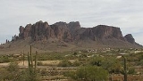
The town is bounded by the Superstition Mountains
(a federal wilderness area
and home of the Lost Dutchman's Gold Mine
) on the east, the Goldfield Mountains with the Bulldog Recreation Area on the north and the city of Mesa, Arizona on the west. Goldfield Ghost Town, a popular tourist spot preserved from former prospecting days, nestles near the western face of Superstition Mountain just off Highway 88 (Apache Trail).
of 2010, there were 35,840 people, 15,574 households, and 9,372 families residing in the city. The population density
was 929.3 people per square mile (358.9/km²). There were 22,771 housing units at an average density of 665.1 per square mile (256.8/km²). The racial makeup of the city was 89.5% White
, 1.2% Black
or African American
, 1.1% Native American
, 0.8% Asian
, 0.1% Pacific Islander
, 4.9% from other races
, and 2.4% from two or more races. Hispanic
or Latino
of any race were 14.4% of the population.
There were 15,574 households out of which 19.6% had children under the age of 18 living with them, 44.6% were married couples
living together, 10.7% had a female householder with no husband present, and 39.8% were non-families. 31.4% of all households were made up of individuals and 15.8% had someone living alone who was 65 years of age or older. The average household size was 2.28 and the average family size was 2.85.
In the city the population had 19.9% under the age of 20, 4.5% from 20 to 24, 20.4% from 25 to 44, 27.1% from 45 to 64, and 26.2% who were 65 years of age or older. The median age was 47.5 years.
The median income (as of the 2000 census) for a household in the city was $33,170, and the median income for a family was $37,726. Males had a median income of $31,283 versus $22,836 for females. The per capita income
for the city was $16,806. About 7.3% of families and 11.6% of the population were below the poverty line, including 18.4% of those under age 18 and 7.4% of those age 65 or over.
Maricopa County, Arizona
-2010:Whereas according to the 2010 U.S. Census Bureau:*73.0% White*5.0% Black*2.1% Native American*3.5% Asian*0.2% Native Hawaiian or Pacific Islander*3.5% Two or more races*12.7% Other races*29.6% Hispanic or Latino -2000:...
and Pinal
Pinal County, Arizona
-2010:Whereas according to the 2010 U.S. Census Bureau:*72.4% White*4.6% Black*5.6% Native American*1.7% Asian*0.4% Native Hawaiian or Pacific Islander*3.8% Two or more races*11.5% Other races*28.5% Hispanic or Latino -2000:...
counties in the U.S. state
U.S. state
A U.S. state is any one of the 50 federated states of the United States of America that share sovereignty with the federal government. Because of this shared sovereignty, an American is a citizen both of the federal entity and of his or her state of domicile. Four states use the official title of...
of Arizona
Arizona
Arizona ; is a state located in the southwestern region of the United States. It is also part of the western United States and the mountain west. The capital and largest city is Phoenix...
. According to the 2010 Census, the population of the city was 35,840, most of whom lived in Pinal County.
Apache Junction is named for the junction of the Apache Trail
Apache Trail
The Apache Trail in Arizona was a stagecoach trail that ran through the Superstition Mountains. It was named the Apache Trail after the Apache Indians who originally used this trail to move through the Superstition Mountains....
and U.S. Highway 60. Superstition Mountain, the westernmost peak of the Superstition Mountains
Superstition Mountains
The Superstition Mountains , popularly referred to as "The Superstitions", are a range of mountains in Arizona located to the east of the Phoenix metropolitan area...
, is nearby.
This city was one of the filming locations for HBO's 1994 film Blind Justice.
Geography
Apache Junction is at 33.415035°N 111.546025°W.According to the United States Census Bureau
United States Census Bureau
The United States Census Bureau is the government agency that is responsible for the United States Census. It also gathers other national demographic and economic data...
, the city has an area of 34.2 square miles (88.6 km²), all land.
The town is bounded by the Superstition Mountains
Superstition Mountains
The Superstition Mountains , popularly referred to as "The Superstitions", are a range of mountains in Arizona located to the east of the Phoenix metropolitan area...
(a federal wilderness area
National Wilderness Preservation System
The National Wilderness Preservation System of the United States protects federally managed land areas designated for preservation in their natural condition. It was established by the Wilderness Act upon the signature of President Lyndon B. Johnson on September 3, 1964...
and home of the Lost Dutchman's Gold Mine
Lost Dutchman's Gold Mine
The Lost Dutchman Gold Mine is reportedly a very rich gold mine hidden in the Superstition Mountains, near Apache Junction, east of Phoenix, Arizona in the United States...
) on the east, the Goldfield Mountains with the Bulldog Recreation Area on the north and the city of Mesa, Arizona on the west. Goldfield Ghost Town, a popular tourist spot preserved from former prospecting days, nestles near the western face of Superstition Mountain just off Highway 88 (Apache Trail).
Demographics
As of the censusCensus
A census is the procedure of systematically acquiring and recording information about the members of a given population. It is a regularly occurring and official count of a particular population. The term is used mostly in connection with national population and housing censuses; other common...
of 2010, there were 35,840 people, 15,574 households, and 9,372 families residing in the city. The population density
Population density
Population density is a measurement of population per unit area or unit volume. It is frequently applied to living organisms, and particularly to humans...
was 929.3 people per square mile (358.9/km²). There were 22,771 housing units at an average density of 665.1 per square mile (256.8/km²). The racial makeup of the city was 89.5% White
Race (United States Census)
Race and ethnicity in the United States Census, as defined by the Federal Office of Management and Budget and the United States Census Bureau, are self-identification data items in which residents choose the race or races with which they most closely identify, and indicate whether or not they are...
, 1.2% Black
Race (United States Census)
Race and ethnicity in the United States Census, as defined by the Federal Office of Management and Budget and the United States Census Bureau, are self-identification data items in which residents choose the race or races with which they most closely identify, and indicate whether or not they are...
or African American
Race (United States Census)
Race and ethnicity in the United States Census, as defined by the Federal Office of Management and Budget and the United States Census Bureau, are self-identification data items in which residents choose the race or races with which they most closely identify, and indicate whether or not they are...
, 1.1% Native American
Race (United States Census)
Race and ethnicity in the United States Census, as defined by the Federal Office of Management and Budget and the United States Census Bureau, are self-identification data items in which residents choose the race or races with which they most closely identify, and indicate whether or not they are...
, 0.8% Asian
Race (United States Census)
Race and ethnicity in the United States Census, as defined by the Federal Office of Management and Budget and the United States Census Bureau, are self-identification data items in which residents choose the race or races with which they most closely identify, and indicate whether or not they are...
, 0.1% Pacific Islander
Race (United States Census)
Race and ethnicity in the United States Census, as defined by the Federal Office of Management and Budget and the United States Census Bureau, are self-identification data items in which residents choose the race or races with which they most closely identify, and indicate whether or not they are...
, 4.9% from other races
Race (United States Census)
Race and ethnicity in the United States Census, as defined by the Federal Office of Management and Budget and the United States Census Bureau, are self-identification data items in which residents choose the race or races with which they most closely identify, and indicate whether or not they are...
, and 2.4% from two or more races. Hispanic
Race (United States Census)
Race and ethnicity in the United States Census, as defined by the Federal Office of Management and Budget and the United States Census Bureau, are self-identification data items in which residents choose the race or races with which they most closely identify, and indicate whether or not they are...
or Latino
Race (United States Census)
Race and ethnicity in the United States Census, as defined by the Federal Office of Management and Budget and the United States Census Bureau, are self-identification data items in which residents choose the race or races with which they most closely identify, and indicate whether or not they are...
of any race were 14.4% of the population.
There were 15,574 households out of which 19.6% had children under the age of 18 living with them, 44.6% were married couples
Marriage
Marriage is a social union or legal contract between people that creates kinship. It is an institution in which interpersonal relationships, usually intimate and sexual, are acknowledged in a variety of ways, depending on the culture or subculture in which it is found...
living together, 10.7% had a female householder with no husband present, and 39.8% were non-families. 31.4% of all households were made up of individuals and 15.8% had someone living alone who was 65 years of age or older. The average household size was 2.28 and the average family size was 2.85.
In the city the population had 19.9% under the age of 20, 4.5% from 20 to 24, 20.4% from 25 to 44, 27.1% from 45 to 64, and 26.2% who were 65 years of age or older. The median age was 47.5 years.
The median income (as of the 2000 census) for a household in the city was $33,170, and the median income for a family was $37,726. Males had a median income of $31,283 versus $22,836 for females. The per capita income
Per capita income
Per capita income or income per person is a measure of mean income within an economic aggregate, such as a country or city. It is calculated by taking a measure of all sources of income in the aggregate and dividing it by the total population...
for the city was $16,806. About 7.3% of families and 11.6% of the population were below the poverty line, including 18.4% of those under age 18 and 7.4% of those age 65 or over.