

Antirrio
Encyclopedia
Antirrio is a former municipality
in Aetolia-Acarnania
, West Greece, Greece
. Since the 2011 local government reform it is part of the municipality Nafpaktia
, of which it is a municipal unit. It is situated on a cape which separates the Gulf of Patras
in the west from the Gulf of Corinth
in the east. Since August 2004 the Rio–Antirrio bridge connects northwestern Greece with the Peloponnese
, across the narrow (2.4 km) Strait of Rio. The name Antirrio means "opposite Rio
". Antirrio is now bypassed to the northeast with GR-5
/E55
with a junction 2 km north with GR-48
/E65
(Amfissa
- Antirrio). Antirrio is about 10 km ENE of Patras
, about 209 km W of Athens
and NW of Aigio
, WSW of Amfissa
, SW of Nafpaktos, E of Messolonghi
and SE of Agrinio
.
) Residential houses are lined up with the highway and the shoreline. The area is surrounded by farmland in the north and northeast and forests in the northwest.
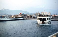 The Port of Antirrio where ferry services began in the 1960s carrying vehicles from the Peloponnese to the Mainland Greece. It was not the only harbor carrying vehicles in the area. Ferry services was almost eliminated when the new Rio-Antirrio bridge opened. It was reduced to mainly vehicles that are not allowed on the bridge.
The highway is now bypassed and has tolls in the eastern part. The junction with GR-48 (Antirrio - Amfissa) was slightly west of the village.
Adjacent to the port is a lighthouse and the fortress of Antirrio.
A mountain which has a few streams is in the north elevating at around 1,100 m. It is closely shaped like a pyramid but at the upper level is like a pyramid but the ridges' width is longer from north to south and the southwestern part is passed by GR-5 at 100 m above sea level. The other is in the north which is around 500 to 600 m and is mainly grassy and forested. A valley is located north of Antirrio and some farms are in the southern half of that mountain especially where the boundary with Nafpaktos are located.
Communities and Municipalities of Greece
For the new municipalities of Greece see the Kallikratis ProgrammeThe municipalities and communities of Greece are one of several levels of government within the organizational structure of that country. Thirteen regions called peripheries form the largest unit of government beneath the State. ...
in Aetolia-Acarnania
Aetolia-Acarnania
Aetolia-Acarnania is one of the regional units of Greece. It is part of the region of West Greece. It is located in the western part of Greece; the regional unit is a combination of the geographic regions Aetolia and Acarnania. Its capital is Missolonghi for historical reasons, with its biggest...
, West Greece, Greece
Greece
Greece , officially the Hellenic Republic , and historically Hellas or the Republic of Greece in English, is a country in southeastern Europe....
. Since the 2011 local government reform it is part of the municipality Nafpaktia
Nafpaktia
Nafpaktia is a municipality in the Aetolia-Acarnania peripheral unit, West Greece Periphery, Greece. The seat of the municipality is the town Naupactus.-Municipality:...
, of which it is a municipal unit. It is situated on a cape which separates the Gulf of Patras
Gulf of Patras
The Gulf of Patras is a branch of the Ionian Sea. On the east, it is closed by the Strait of Rion between capes Rio, Greece and Antirrio, near the Rio-Antirio bridge. On the west, it is bounded by a line from Oxeia island to Cape Araxos...
in the west from the Gulf of Corinth
Gulf of Corinth
The Gulf of Corinth or the Corinthian Gulf is a deep inlet of the Ionian Sea separating the Peloponnese from western mainland Greece...
in the east. Since August 2004 the Rio–Antirrio bridge connects northwestern Greece with the Peloponnese
Peloponnese
The Peloponnese, Peloponnesos or Peloponnesus , is a large peninsula , located in a region of southern Greece, forming the part of the country south of the Gulf of Corinth...
, across the narrow (2.4 km) Strait of Rio. The name Antirrio means "opposite Rio
Rio, Greece
Rio is a town and a former municipality in Achaea, West Greece, Greece. Since the 2011 local government reform it is part of the municipality Patras, of which it is a municipal unit. The former municipality had a population of around 13,000.- Geography :...
". Antirrio is now bypassed to the northeast with GR-5
Greek National Road 5
Greek National Road 5 is a highway in Western Greece. It runs from 2 km south of Rio at GR-8/GR-9 , or at the beginning of the Patras By-Pass in the south up to the city centre of Ioannina. It is now connected with a new bridge, the Rio-Antirio bridge and for 5 km is a joint with GR-48...
/E55
European route E55
European route E 55 is a E-route. It passes through the following cities:Helsingborg … Helsingør – Copenhagen – Køge – Vordingborg – Nykøbing Falster – Gedser … Rostock – Berlin – Lübbenau – Dresden – Teplice – Prague – Tábor – Linz – Salzburg – Villach – Tarvisio – Udine – Palmanova – Mestre...
with a junction 2 km north with GR-48
Greek National Road 48
Greek National Road 48 is a highway in Western and Central Greece. It runs from 2 km south of Rio at GR-8/GR-9 , or at the beginning of the Patras By-Pass in the south up to near Levadia. It is now connected with a new bridge, the Rio-Antirio bridge and for 5 km is a joint with GR-5...
/E65
European route E65
European route E 65 is a north-south Class-A European route that begins in Malmö, Sweden and ends in Chaniá, Greece. The road is about in length.-Itinerary:* Sweden** E 65: Malmö – Ystad* Baltic sea, ferry Ystad-Świnoujście* Poland...
(Amfissa
Amfissa
Amfissa is a town and a former municipality in Phocis, Greece. Since the 2011 local government reform it is part of the municipality Delphi, of which it is the seat and a municipal unit. It is also the capital of the regional unit of Phocis...
- Antirrio). Antirrio is about 10 km ENE of Patras
Patras
Patras , ) is Greece's third largest urban area and the regional capital of West Greece, located in northern Peloponnese, 215 kilometers west of Athens...
, about 209 km W of Athens
Athens
Athens , is the capital and largest city of Greece. Athens dominates the Attica region and is one of the world's oldest cities, as its recorded history spans around 3,400 years. Classical Athens was a powerful city-state...
and NW of Aigio
Aigio
Aigio is a town and a former municipality in Achaea, West Greece, Greece. Since the 2011 local government reform it is part of the municipality Aigialeia, of which it is the seat and a municipal unit. Its population is around 30,000. Aigio is surrounded by trees in the north and cliffs in the...
, WSW of Amfissa
Amfissa
Amfissa is a town and a former municipality in Phocis, Greece. Since the 2011 local government reform it is part of the municipality Delphi, of which it is the seat and a municipal unit. It is also the capital of the regional unit of Phocis...
, SW of Nafpaktos, E of Messolonghi
Messolonghi
Missolonghi is a town of 12,225 people in western Greece. The town is the capital of Aetolia-Acarnania and is also its third largest town. It is the seat of the municipality of Iera Poli Mesolongiou . Missolonghi is linked to, although bypassed since the 1960s by, GR-5/E55...
and SE of Agrinio
Agrinio
Agrinion is the largest city and municipality of the Aetolia-Acarnania peripheral unit of Greece, with 96,321 inhabitants. It is the economical center of Aetolia-Acarnania, although its capital is the town of Mesolonghi. The settlement dates back to ancient times...
.
Subdivisions
The municipal unit Antirrio is subdivided into the following communities (constituent villages in brackets):- Antirrio (Antirrio, Karaoulia, Myrtia, Spartorachi)
- Makyneia (Makyneia, Agios Polykarpos, Agrapidokampos, Riza)
- Molykreio (Molykreio, Ano Platanitis, Fragkaiika)
Geography
The community has a school, a gymnasium, a church, a post office, a beach, and a square (plateiaPlateia
Plateia or platia is the Greek word for town square. Most Greek and Cypriot cities have several town squares which are a point of reference in travelling and guiding...
) Residential houses are lined up with the highway and the shoreline. The area is surrounded by farmland in the north and northeast and forests in the northwest.
The highway is now bypassed and has tolls in the eastern part. The junction with GR-48 (Antirrio - Amfissa) was slightly west of the village.
Adjacent to the port is a lighthouse and the fortress of Antirrio.
A mountain which has a few streams is in the north elevating at around 1,100 m. It is closely shaped like a pyramid but at the upper level is like a pyramid but the ridges' width is longer from north to south and the southwestern part is passed by GR-5 at 100 m above sea level. The other is in the north which is around 500 to 600 m and is mainly grassy and forested. A valley is located north of Antirrio and some farms are in the southern half of that mountain especially where the boundary with Nafpaktos are located.
Historical population
| Year | Municipal district | Municipality |
|---|---|---|
| 1981 | 916 | - |
| 1991 | 676 | 2,531 |
| 2001 | 1,100 | - |
External links
- Municipality of Antirrio
- http://www.qsl.net/sv2ael/sv2ael.files/faroi/details/antirio.htm - Lighthouse
- GTP - Antirio
- GTP - Municipality of Antirio
| North: Nafpaktos (NE) | ||
| West: Gulf of Patras Gulf of Patras The Gulf of Patras is a branch of the Ionian Sea. On the east, it is closed by the Strait of Rion between capes Rio, Greece and Antirrio, near the Rio-Antirio bridge. On the west, it is bounded by a line from Oxeia island to Cape Araxos... |
Antirrio | East: Gulf of Corinth Gulf of Corinth The Gulf of Corinth or the Corinthian Gulf is a deep inlet of the Ionian Sea separating the Peloponnese from western mainland Greece... |
| South: Strait of Rio-Antirio |