
Andreanof Islands
Encyclopedia
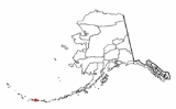
The Andreanof Islands are a group of islands in the Aleutian Islands in southwest Alaska
. They are located between Amchitka Pass
and the Rat Islands
group to the west, and Amukta Pass
and the Islands of Four Mountains
group to the east, at about 52° North and 172°57' to 179°09' West. The islands extend about 275 miles (440 km). The total land area of all islands (including the Delarof Islands) is 1,515.349 sq mi (3,924.737 km²). The total population was 412 persons as of the 2000 census
, the vast majority in the city of Adak
on Adak Island
.
 The Delarof Islands
, a subgroup of the Andreanof Islands, constitute the westernmost islands of the latter group.
The largest islands in the group are, from west to east, Gareloi
, Tanaga
, Kanaga
, Adak
, Kagalaska
, Great Sitkin
, Atka
, Amlia
, and Seguam
.
The islands are usually foggy and are treeless because of the almost constant wind. They were named for the Russian navigator, Andreyan Tolstykh, who was the first to explore the islands in 1761.
There were several United States military bases on the islands during World War II
. The bases on Adak were enlarged and made permanent after the war but were closed in 1995.
The islands are particularly prone to earthquakes, often many with a magnitude
of over 3 on the Richter scale occur each day.
Alaska
Alaska is the largest state in the United States by area. It is situated in the northwest extremity of the North American continent, with Canada to the east, the Arctic Ocean to the north, and the Pacific Ocean to the west and south, with Russia further west across the Bering Strait...
. They are located between Amchitka Pass
Amchitka Pass
Amchitka Pass is a strait in Alaska, United States. It is located in the Aleutian Islands, between the Rat Islands group to the west and the Delarof Islands to the east. Amchitka Pass has a least width of 50 miles and depths of 49 to over 1,000 fathoms. The islands on both sides of the pass should...
and the Rat Islands
Rat Islands
The Rat Islands are a volcanic group of islands in the Aleutian Islands in southwest Alaska, between Buldir Island and the Near Islands group to its west, and Amchitka Pass and the Andreanof Islands group to its east, at about ....
group to the west, and Amukta Pass
Amukta Pass
Amukta Pass is a wide strait between the Bering Sea and the North Pacific Ocean in the Aleutian Islands in Alaska. It lies between Amukta Island to the east and Seguam Island to the west.- 2011 earthquake :...
and the Islands of Four Mountains
Islands of Four Mountains
Islands of Four Mountains is an island grouping of the Aleutian Islands in Alaska, United States. The chain includes, from west to east, Amukta, Chagulak, Yunaska, Herbert, Carlisle, Chuginadak, Uliaga, and Kagamil Islands. This island chain is located between Amukta Pass and the Andreanof Islands...
group to the east, at about 52° North and 172°57' to 179°09' West. The islands extend about 275 miles (440 km). The total land area of all islands (including the Delarof Islands) is 1,515.349 sq mi (3,924.737 km²). The total population was 412 persons as of the 2000 census
United States Census, 2000
The Twenty-second United States Census, known as Census 2000 and conducted by the Census Bureau, determined the resident population of the United States on April 1, 2000, to be 281,421,906, an increase of 13.2% over the 248,709,873 persons enumerated during the 1990 Census...
, the vast majority in the city of Adak
Adak, Alaska
Adak , formerly Adak Station, is a city in the Aleutians West Census Area, Alaska, United States. At the 2010 census the population was 326. It is the westernmost municipality in the United States and the southernmost city in Alaska. The city is the former location of the Adak Army Base and Adak...
on Adak Island
Adak Island
Adak Island is an island near the western extent of the Andreanof Islands group of the Aleutian Islands in Alaska. Alaska's southernmost town, Adak, is located on the island...
.
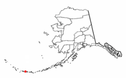
Delarof Islands
The Delarof Islands are a group of small islands at the extreme western end of the Andreanof Islands group in the central Aleutian Islands, Alaska...
, a subgroup of the Andreanof Islands, constitute the westernmost islands of the latter group.
The largest islands in the group are, from west to east, Gareloi
Gareloi Island
Gareloi is a volcanic island in the Delarof Islands of the Aleutian Islands of Alaska. It is located between the Tanaga Pass and the Amchitka Pass....
, Tanaga
Tanaga Island
Tanaga Island is an island in the western Andreanof Islands, in the southwest part of the Aleutian Islands, Alaska. The island has a land area of , making it the 33rd largest island in the United States. Its highest point is volcano Mount Tanaga at ....
, Kanaga
Kanaga Island
Kanaga Island is a part of the Andreanof Islands group of the Aleutian Islands in Alaska. The island measures roughly 30 miles long and between 4 and 8 miles wide with an area of 142 sq mi , making it the 42nd largest island in the United States...
, Adak
Adak Island
Adak Island is an island near the western extent of the Andreanof Islands group of the Aleutian Islands in Alaska. Alaska's southernmost town, Adak, is located on the island...
, Kagalaska
Kagalaska Island
Kagalaska Island is an island in the Andreanof Islands of the Aleutian Islands of Alaska.The island is in length and wide. It is separated from Adak Island to the west by Kagalaska Strait which is approximately wide at its narrowest point...
, Great Sitkin
Great Sitkin Island
Great Sitkin Island is a volcanic island in the Andreanof Islands of the Aleutian Islands of Alaska. The island covers a total area of and lies slightly north of a group islands which are located between Adak Island and Atka Island....
, Atka
Atka Island
Atka Island is the largest island in the Andreanof Islands of the Aleutian Islands of Alaska. The island is east of Adak Island. It is long and wide with a land area of , making it the 22nd largest island in the United States. The northeast of Atka Island contains the Korovin volcano which...
, Amlia
Amlia
Amlia is an island in the Aleutian Islands. It is located near the eastern end of the Andreanof Islands and is situated between Atka Island and Seguam Island....
, and Seguam
Seguam Island
Seguam Island is a small volcanic island in the Andreanof Islands group in the Aleutian Islands of Alaska. The island is mountainous and oval shaped with a land area of . It is long and wide. The 2000 census reported a population of one person....
.
The islands are usually foggy and are treeless because of the almost constant wind. They were named for the Russian navigator, Andreyan Tolstykh, who was the first to explore the islands in 1761.
There were several United States military bases on the islands during World War II
World War II
World War II, or the Second World War , was a global conflict lasting from 1939 to 1945, involving most of the world's nations—including all of the great powers—eventually forming two opposing military alliances: the Allies and the Axis...
. The bases on Adak were enlarged and made permanent after the war but were closed in 1995.
The islands are particularly prone to earthquakes, often many with a magnitude
Richter magnitude scale
The expression Richter magnitude scale refers to a number of ways to assign a single number to quantify the energy contained in an earthquake....
of over 3 on the Richter scale occur each day.
See also
- 1957 Andreanof Islands Earthquake1957 Andreanof Islands earthquakeThe 1957 Andreanof Islands earthquake was a magnitude 8.6 MW megathrust earthquake that took place on March 9, 1957. It was centered at in the Alaska-Aleutian megathrust, south of the Andreanof Islands group of the Aleutian Islands in the U.S...
- 2007 Andreanof Islands earthquake2007 Andreanof Islands earthquakeThe 2007 Andreanof Islands Earthquake was a magnitude 7.2 earthquake that took place on December 19, 2007, at 09:30:30 UTC. It was centered at , west of Adak in the Andreanof Islands group of the Aleutian Islands in the U.S. state of Alaska....
http://www.weather.gov.hk/gts/equake/eqpress_e/eqpress_e.20070429.2206.htm