

Ancient trackway
Encyclopedia
Ancient trackway can refer to any track or trail whose origin is lost in antiquity
. Such paths existed from the earliest prehistoric times and in every inhabited part of the globe. Many ancient trackways can still be seen and walked in the United Kingdom
and Ireland
.
 Some of the earliest trackways for human ancestors have been discovered in Tanzania
. The Laetoli
trackway is famous for the hominin footprints preserved in volcanic ash
. After the footprints were made in powdery ash, soft rain cemented the ash layer to tuff
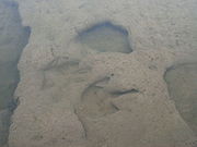
, preserving the prints. The hominid prints were produced by three individuals, one walking in the footprints of the other, making the original tracks difficult to discover. As the tracks lead in the same direction, they might have been produced by a group—but there is nothing else to support the common reconstruction of a nuclear family visiting the waterhole together.
, two ancient trackways have been found containing footprints, one at Langebaan and one at Nahoon. Both trackways occur in calcareous eolianites or hardened sand dunes. At Nahoon, trackways of at least five species of vertebrates, including three hominid footprints, are preserved as casts. The prints at Langebaan
are the oldest human footprints, dated to approximately 117,000 years old.
 In the United States
, dinosaur
footprints and trackways are found in the Glen Rose Formation
, the most famous of these being the Paluxy River
site in Dinosaur Valley State Park
. These were the first sauropoda
footprints scientifically documented, and were designated a US National Natural Landmark
in 1969. Some are as large as about 3 feet across. The prints are thought to have been preserved originally in a tidal flat or a lagoon
. There are tracks from two types of dinosaur. The first type of tracks are from a sauropoda
and were made by an animal of 30 to 50 feet in length, perhaps a brachiosaurid such as Pleurocoelus , and the second tracks by a theropoda
, an animal of 20 to 30 feet in length, perhaps an Acrocanthosaurus
. A variety of scenarios was proposed to explain the tracks, but most likely represent twelve sauropods "probably as a herd, followed somewhat later by three theropods that may or may not have been stalking -- but that certainly were not attacking."
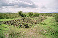
, in the Iron Age
, the Corlea trackway is an ancient road built upon a bog consisting of packed hazel, birch and alder planks placed lengthways across the track, and occasional cross timbers for support. Other bog trackways or "toghers" have also been discovered dating to around 4,000BC. The Corlea trackway dates from approx 148BC and was excavated in 1994. It is the largest trackway of its kind to be uncovered in Europe. Other examples of this type of trackway can be seen in England
(Somerset Levels
) and Germany
.
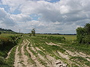
, many trackways were built upon by the Romans to form the foundations for their roads. Prior to this, people used trackways to travel between settlements but this was unsuitable for the swift movement of troops and equipment.

 These settlements were connected with each other by the ancient trackways, sometimes referred to as green ways
. The tracks often followed natural contours in the landscape, and evolved over time as animals were driven from place to place and people walked to and from neighbouring settlements. Much of the land was forested; the lower valleys provided fertile land and were ideal places for fishing, agriculture and the rearing of cattle.
The trackways provided links between farmsteads and fields, other farmsteads, and neighbouring long barrow
tombs. Trackways also joined the separate localities to the camp meeting places and cross-country flint roads. Others were more likely to have been processional ways, such as the one leading to the gigantic temple at Avebury
in Wiltshire. Long distance ways included those now known as
Some trackways followed the tops of higher land, whilst others progressed along the lower slopes. The lowland areas were thickly forested and poorly drained and for long distance travel there was an advantage in following the top of a line of hills or ridgeways
. The Ridgeway in fact probably ran from The Wash
along the chalk
escarpment
across Britain via Avebury
to the English Channel
across Salisbury Plain
, a much longer route than the current national footpath suggests.
The skills needed to develop tracks across bog
lands, such as those in the Somerset Levels
, were learnt by early people. Known as corduroy roads, they were formed when huge quantities of alder
poles and brushwood were used to link the fen
islands across the marshes. The Sweet track
in the Glastonbury
fens, Somerset
is believed to be the oldest purpose built road in the world and has been dated to the 3800s BC.
On occasion, where rivers caused an obstacle to progress, bridges were built across them, and several roads met to use the bridge. Major settlements grew around the bridges, providing sustenance to travellers and their animals using the trackways. There are many good examples of this: three follow.
dates back to the dawn of British history, when its founders showed remarkable discrimination in choosing its site. Nestling in a fertile valley on the banks of the River Thames
, it was an ideal place for fishing, agriculture and the rearing of cattle. The ancient trackways, in particular the Icknield Way, provided lines of communication converging on its ford. The remains of the ramparts still surround the town and are the successors of the rudimentary fortifications of the old British settlement, which were adapted in turn by Roman, Anglo Saxon and Norman
conquerors.
in West Midlands
. Brownhills has been a meeting point for ancient roads and trackways since prehistoric times. It is thought that the Watling Street
was in use before the Romans came and predates Roman road
s; what were later called the Chester Road and Coventry Road are also thought to have been ancient trackways.
in Somerset
is an Iron Age
camp covering some 18 acre
s (73,000 m²) and is considered to be one of the most impressive Iron Age sites in Britain. It is the focal point of many ancient trackways and is guarded by four huge banks with a height in places of over 40 feet (12 m) from the bottom of the ditch.
, in his books Early British Trackways and The Old Straight Track
. Watkins theorized that these alignments were created for ease of overland trekking on ancient trackways during neolithic
times and had persisted in the landscape over millennia.
Ancient history
Ancient history is the study of the written past from the beginning of recorded human history to the Early Middle Ages. The span of recorded history is roughly 5,000 years, with Cuneiform script, the oldest discovered form of coherent writing, from the protoliterate period around the 30th century BC...
. Such paths existed from the earliest prehistoric times and in every inhabited part of the globe. Many ancient trackways can still be seen and walked in the United Kingdom
United Kingdom
The United Kingdom of Great Britain and Northern IrelandIn the United Kingdom and Dependencies, other languages have been officially recognised as legitimate autochthonous languages under the European Charter for Regional or Minority Languages...
and Ireland
Republic of Ireland
Ireland , described as the Republic of Ireland , is a sovereign state in Europe occupying approximately five-sixths of the island of the same name. Its capital is Dublin. Ireland, which had a population of 4.58 million in 2011, is a constitutional republic governed as a parliamentary democracy,...
.
History
The Concise Oxford Dictionary gives the definition of "trackway" as "a path formed by the repeated treading of people or animals". Over time, many of these trackways were developed into roads. Many trackways, of both animals and people, have been preserved in volcanic ash or bog land, and reveal historical details of life in ancient times.Tanzania
Tanzania
The United Republic of Tanzania is a country in East Africa bordered by Kenya and Uganda to the north, Rwanda, Burundi, and the Democratic Republic of the Congo to the west, and Zambia, Malawi, and Mozambique to the south. The country's eastern borders lie on the Indian Ocean.Tanzania is a state...
. The Laetoli
Laetoli
Laetoli is a site in Tanzania, dated to the Plio-Pleistocene and famous for its hominin footprints, preserved in volcanic ash . The site of the Laetoli footprints is located 45 km south of Olduvai gorge.-Date:...
trackway is famous for the hominin footprints preserved in volcanic ash
Volcanic ash
Volcanic ash consists of small tephra, which are bits of pulverized rock and glass created by volcanic eruptions, less than in diameter. There are three mechanisms of volcanic ash formation: gas release under decompression causing magmatic eruptions; thermal contraction from chilling on contact...
. After the footprints were made in powdery ash, soft rain cemented the ash layer to tuff
Tuff
Tuff is a type of rock consisting of consolidated volcanic ash ejected from vents during a volcanic eruption. Tuff is sometimes called tufa, particularly when used as construction material, although tufa also refers to a quite different rock. Rock that contains greater than 50% tuff is considered...
, preserving the prints. The hominid prints were produced by three individuals, one walking in the footprints of the other, making the original tracks difficult to discover. As the tracks lead in the same direction, they might have been produced by a group—but there is nothing else to support the common reconstruction of a nuclear family visiting the waterhole together.
South Africa
In South AfricaSouth Africa
The Republic of South Africa is a country in southern Africa. Located at the southern tip of Africa, it is divided into nine provinces, with of coastline on the Atlantic and Indian oceans...
, two ancient trackways have been found containing footprints, one at Langebaan and one at Nahoon. Both trackways occur in calcareous eolianites or hardened sand dunes. At Nahoon, trackways of at least five species of vertebrates, including three hominid footprints, are preserved as casts. The prints at Langebaan
Langebaan
Langebaan is a town in the Western Cape province of South Africa on the eastern shore of Langebaan Lagoon.Langebaan is situated 120 km north of Cape Town, just off the R27, about 28km from Vredenburg and 20km from Saldanha Bay...
are the oldest human footprints, dated to approximately 117,000 years old.
United States
United States
The United States of America is a federal constitutional republic comprising fifty states and a federal district...
, dinosaur
Dinosaur
Dinosaurs are a diverse group of animals of the clade and superorder Dinosauria. They were the dominant terrestrial vertebrates for over 160 million years, from the late Triassic period until the end of the Cretaceous , when the Cretaceous–Paleogene extinction event led to the extinction of...
footprints and trackways are found in the Glen Rose Formation
Glen Rose Formation
The Glen Rose Formation is a shallow marine to shoreline geological formation from the lower Cretaceous period exposed over a large area from South Central to North Central Texas...
, the most famous of these being the Paluxy River
Paluxy River
The Paluxy River is a river in the U.S. state of Texas. It is a tributary of the Brazos River. It is formed by the convergence of the North Paluxy River and the South Paluxy River near Bluff Dale, Texas in Erath County and flows a distance of before joining the Brazos just to the east of Glen...
site in Dinosaur Valley State Park
Dinosaur Valley State Park
- History :Dinosaur Valley State Park, located just northwest of Glen Rose in Somervell County, is a scenic park set astride the Paluxy River. The land for the park was acquired from private owners under the State Parks Bonds Program during 1968 and opened to the public in 1972...
. These were the first sauropoda
Sauropoda
Sauropoda , or the sauropods , are an infraorder of saurischian dinosaurs. They had long necks, long tails, small heads , and thick, pillar-like legs. They are notable for the enormous sizes attained by some species, and the group includes the largest animals to have ever lived on land...
footprints scientifically documented, and were designated a US National Natural Landmark
National Natural Landmark
The National Natural Landmark program recognizes and encourages the conservation of outstanding examples of the natural history of the United States. It is the only natural areas program of national scope that identifies and recognizes the best examples of biological and geological features in...
in 1969. Some are as large as about 3 feet across. The prints are thought to have been preserved originally in a tidal flat or a lagoon
Lagoon
A lagoon is a body of shallow sea water or brackish water separated from the sea by some form of barrier. The EU's habitat directive defines lagoons as "expanses of shallow coastal salt water, of varying salinity or water volume, wholly or partially separated from the sea by sand banks or shingle,...
. There are tracks from two types of dinosaur. The first type of tracks are from a sauropoda
Sauropoda
Sauropoda , or the sauropods , are an infraorder of saurischian dinosaurs. They had long necks, long tails, small heads , and thick, pillar-like legs. They are notable for the enormous sizes attained by some species, and the group includes the largest animals to have ever lived on land...
and were made by an animal of 30 to 50 feet in length, perhaps a brachiosaurid such as Pleurocoelus , and the second tracks by a theropoda
Theropoda
Theropoda is both a suborder of bipedal saurischian dinosaurs, and a clade consisting of that suborder and its descendants . Dinosaurs belonging to the suborder theropoda were primarily carnivorous, although a number of theropod groups evolved herbivory, omnivory, and insectivory...
, an animal of 20 to 30 feet in length, perhaps an Acrocanthosaurus
Acrocanthosaurus
Acrocanthosaurus is a genus of theropod dinosaur that existed in what is now North America during the Aptian and early Albian stages of the Early Cretaceous. Like most dinosaur genera, Acrocanthosaurus contains only a single species, A. atokensis. Its fossil remains are found mainly in the U.S...
. A variety of scenarios was proposed to explain the tracks, but most likely represent twelve sauropods "probably as a herd, followed somewhat later by three theropods that may or may not have been stalking -- but that certainly were not attacking."
Ireland
In IrelandIreland
Ireland is an island to the northwest of continental Europe. It is the third-largest island in Europe and the twentieth-largest island on Earth...
, in the Iron Age
Iron Age
The Iron Age is the archaeological period generally occurring after the Bronze Age, marked by the prevalent use of iron. The early period of the age is characterized by the widespread use of iron or steel. The adoption of such material coincided with other changes in society, including differing...
, the Corlea trackway is an ancient road built upon a bog consisting of packed hazel, birch and alder planks placed lengthways across the track, and occasional cross timbers for support. Other bog trackways or "toghers" have also been discovered dating to around 4,000BC. The Corlea trackway dates from approx 148BC and was excavated in 1994. It is the largest trackway of its kind to be uncovered in Europe. Other examples of this type of trackway can be seen in England
England
England is a country that is part of the United Kingdom. It shares land borders with Scotland to the north and Wales to the west; the Irish Sea is to the north west, the Celtic Sea to the south west, with the North Sea to the east and the English Channel to the south separating it from continental...
(Somerset Levels
Somerset Levels
The Somerset Levels, or the Somerset Levels and Moors as they are less commonly but more correctly known, is a sparsely populated coastal plain and wetland area of central Somerset, South West England, between the Quantock and Mendip Hills...
) and Germany
Germany
Germany , officially the Federal Republic of Germany , is a federal parliamentary republic in Europe. The country consists of 16 states while the capital and largest city is Berlin. Germany covers an area of 357,021 km2 and has a largely temperate seasonal climate...
.
Great Britain
In Roman BritainRoman Britain
Roman Britain was the part of the island of Great Britain controlled by the Roman Empire from AD 43 until ca. AD 410.The Romans referred to the imperial province as Britannia, which eventually comprised all of the island of Great Britain south of the fluid frontier with Caledonia...
, many trackways were built upon by the Romans to form the foundations for their roads. Prior to this, people used trackways to travel between settlements but this was unsuitable for the swift movement of troops and equipment.
Green lane
A green lane is a type of road, usually an unpaved rural route.-England and Wales:In particular, a green lane is unsurfaced, and may be so infrequently used that there is no wearing of the surface, allowing vegetation to colonise freely, hence 'green'...
. The tracks often followed natural contours in the landscape, and evolved over time as animals were driven from place to place and people walked to and from neighbouring settlements. Much of the land was forested; the lower valleys provided fertile land and were ideal places for fishing, agriculture and the rearing of cattle.
The trackways provided links between farmsteads and fields, other farmsteads, and neighbouring long barrow
Long barrow
A long barrow is a prehistoric monument dating to the early Neolithic period. They are rectangular or trapezoidal tumuli or earth mounds traditionally interpreted as collective tombs...
tombs. Trackways also joined the separate localities to the camp meeting places and cross-country flint roads. Others were more likely to have been processional ways, such as the one leading to the gigantic temple at Avebury
Avebury
Avebury is a Neolithic henge monument containing three stone circles which is located around the village of Avebury in Wiltshire, south west England. Unique amongst megalithic monuments, Avebury contains the largest stone circle in Europe, and is one of the best known prehistoric sites in Britain...
in Wiltshire. Long distance ways included those now known as
- the Icknield WayIcknield WayThe Icknield Way is an ancient trackway in southern England. It follows the chalk escarpment that includes the Berkshire Downs and Chiltern Hills.-Background:...
, running over from BuckinghamshireBuckinghamshireBuckinghamshire is a ceremonial and non-metropolitan home county in South East England. The county town is Aylesbury, the largest town in the ceremonial county is Milton Keynes and largest town in the non-metropolitan county is High Wycombe....
to NorfolkNorfolkNorfolk is a low-lying county in the East of England. It has borders with Lincolnshire to the west, Cambridgeshire to the west and southwest and Suffolk to the south. Its northern and eastern boundaries are the North Sea coast and to the north-west the county is bordered by The Wash. The county...
, - the Ridgeway National Trail, running 85 miles (137 km) along chalk hills from WiltshireWiltshireWiltshire is a ceremonial county in South West England. It is landlocked and borders the counties of Dorset, Somerset, Hampshire, Gloucestershire, Oxfordshire and Berkshire. It contains the unitary authority of Swindon and covers...
to BuckinghamshireBuckinghamshireBuckinghamshire is a ceremonial and non-metropolitan home county in South East England. The county town is Aylesbury, the largest town in the ceremonial county is Milton Keynes and largest town in the non-metropolitan county is High Wycombe....
, - the Harrow WayHarrow WayThe Harrow Way forms the western part of the Old Way, an ancient trackway in the south of England, dating from the Neolithic period, which can be traced from Rochester and the Channel ports in the Straits of Dover along the North Downs and through Guildford, Farnham, Andover and Basingstoke to...
and - the Pilgrims' WayPilgrims' WayThe Pilgrims' Way is the historic route supposed to have been taken by pilgrims from Winchester in Hampshire, England, to the shrine of Thomas Becket at Canterbury in Kent...
in the North DownsNorth DownsThe North Downs are a ridge of chalk hills in south east England that stretch from Farnham in Surrey to the White Cliffs of Dover in Kent. The North Downs lie within two Areas of Outstanding Natural Beauty , the Surrey Hills and the Kent Downs...
.
Some trackways followed the tops of higher land, whilst others progressed along the lower slopes. The lowland areas were thickly forested and poorly drained and for long distance travel there was an advantage in following the top of a line of hills or ridgeways
Ridgeway (track)
Ridgeways are a particular type of ancient road that exploits the hard surface of hilltop ridges for use as unpaved, zero-maintenance roads, though they often have the disadvantage of steeper gradients along their courses, and sometimes quite narrow widths. Before the advent of turnpikes or toll...
. The Ridgeway in fact probably ran from The Wash
The Wash
The Wash is the square-mouthed bay and estuary on the northwest margin of East Anglia on the east coast of England, where Norfolk meets Lincolnshire. It is among the largest estuaries in the United Kingdom...
along the chalk
Chalk
Chalk is a soft, white, porous sedimentary rock, a form of limestone composed of the mineral calcite. Calcite is calcium carbonate or CaCO3. It forms under reasonably deep marine conditions from the gradual accumulation of minute calcite plates shed from micro-organisms called coccolithophores....
escarpment
Escarpment
An escarpment is a steep slope or long cliff that occurs from erosion or faulting and separates two relatively level areas of differing elevations.-Description and variants:...
across Britain via Avebury
Avebury
Avebury is a Neolithic henge monument containing three stone circles which is located around the village of Avebury in Wiltshire, south west England. Unique amongst megalithic monuments, Avebury contains the largest stone circle in Europe, and is one of the best known prehistoric sites in Britain...
to the English Channel
English Channel
The English Channel , often referred to simply as the Channel, is an arm of the Atlantic Ocean that separates southern England from northern France, and joins the North Sea to the Atlantic. It is about long and varies in width from at its widest to in the Strait of Dover...
across Salisbury Plain
Salisbury Plain
Salisbury Plain is a chalk plateau in central southern England covering . It is part of the Southern England Chalk Formation and largely lies within the county of Wiltshire, with a little in Hampshire. The plain is famous for its rich archaeology, including Stonehenge, one of England's best known...
, a much longer route than the current national footpath suggests.
The skills needed to develop tracks across bog
Bog
A bog, quagmire or mire is a wetland that accumulates acidic peat, a deposit of dead plant material—often mosses or, in Arctic climates, lichens....
lands, such as those in the Somerset Levels
Somerset Levels
The Somerset Levels, or the Somerset Levels and Moors as they are less commonly but more correctly known, is a sparsely populated coastal plain and wetland area of central Somerset, South West England, between the Quantock and Mendip Hills...
, were learnt by early people. Known as corduroy roads, they were formed when huge quantities of alder
Alder
Alder is the common name of a genus of flowering plants belonging to the birch family . The genus comprises about 30 species of monoecious trees and shrubs, few reaching large size, distributed throughout the North Temperate Zone and in the Americas along the Andes southwards to...
poles and brushwood were used to link the fen
Fen
A fen is a type of wetland fed by mineral-rich surface water or groundwater. Fens are characterised by their water chemistry, which is neutral or alkaline, with relatively high dissolved mineral levels but few other plant nutrients...
islands across the marshes. The Sweet track
Sweet Track
The Sweet Track is an ancient causeway in the Somerset Levels, England. It was built in 3807 or 3806 BC and has been claimed to be the oldest road in the world. It was the oldest timber trackway discovered in Northern Europe until the 2009 discovery of a 6,000 year-old trackway in Belmarsh Prison...
in the Glastonbury
Glastonbury
Glastonbury is a small town in Somerset, England, situated at a dry point on the low lying Somerset Levels, south of Bristol. The town, which is in the Mendip district, had a population of 8,784 in the 2001 census...
fens, Somerset
Somerset
The ceremonial and non-metropolitan county of Somerset in South West England borders Bristol and Gloucestershire to the north, Wiltshire to the east, Dorset to the south-east, and Devon to the south-west. It is partly bounded to the north and west by the Bristol Channel and the estuary of the...
is believed to be the oldest purpose built road in the world and has been dated to the 3800s BC.
On occasion, where rivers caused an obstacle to progress, bridges were built across them, and several roads met to use the bridge. Major settlements grew around the bridges, providing sustenance to travellers and their animals using the trackways. There are many good examples of this: three follow.
Wallingford
The original settlement at Wallingford in OxfordshireOxfordshire
Oxfordshire is a county in the South East region of England, bordering on Warwickshire and Northamptonshire , Buckinghamshire , Berkshire , Wiltshire and Gloucestershire ....
dates back to the dawn of British history, when its founders showed remarkable discrimination in choosing its site. Nestling in a fertile valley on the banks of the River Thames
River Thames
The River Thames flows through southern England. It is the longest river entirely in England and the second longest in the United Kingdom. While it is best known because its lower reaches flow through central London, the river flows alongside several other towns and cities, including Oxford,...
, it was an ideal place for fishing, agriculture and the rearing of cattle. The ancient trackways, in particular the Icknield Way, provided lines of communication converging on its ford. The remains of the ramparts still surround the town and are the successors of the rudimentary fortifications of the old British settlement, which were adapted in turn by Roman, Anglo Saxon and Norman
Normans
The Normans were the people who gave their name to Normandy, a region in northern France. They were descended from Norse Viking conquerors of the territory and the native population of Frankish and Gallo-Roman stock...
conquerors.
Brownhills
A similar site is BrownhillsBrownhills
Brownhills is a town in the West Midlands, England. Located on the edge of Cannock Chase near the large artificial lake Chasewater, it is north-east of Walsall and a similar distance south-west of Lichfield. It is part of the Metropolitan Borough of Walsall and the Aldridge-Brownhills...
in West Midlands
West Midlands (county)
The West Midlands is a metropolitan county in western central England with a 2009 estimated population of 2,638,700. It came into existence as a metropolitan county in 1974 after the passage of the Local Government Act 1972, formed from parts of Staffordshire, Worcestershire and Warwickshire. The...
. Brownhills has been a meeting point for ancient roads and trackways since prehistoric times. It is thought that the Watling Street
Watling Street
Watling Street is the name given to an ancient trackway in England and Wales that was first used by the Britons mainly between the modern cities of Canterbury and St Albans. The Romans later paved the route, part of which is identified on the Antonine Itinerary as Iter III: "Item a Londinio ad...
was in use before the Romans came and predates Roman road
Roman road
The Roman roads were a vital part of the development of the Roman state, from about 500 BC through the expansion during the Roman Republic and the Roman Empire. Roman roads enabled the Romans to move armies and trade goods and to communicate. The Roman road system spanned more than 400,000 km...
s; what were later called the Chester Road and Coventry Road are also thought to have been ancient trackways.
Cadbury Castle and South Cadbury Village
Cadbury CastleCadbury Castle, Somerset
Cadbury Castle is an Iron Age hill fort in the civil parish of South Cadbury in the English county of Somerset. It is a Scheduled Ancient Monument and associated with King Arthur.-Background:...
in Somerset
Somerset
The ceremonial and non-metropolitan county of Somerset in South West England borders Bristol and Gloucestershire to the north, Wiltshire to the east, Dorset to the south-east, and Devon to the south-west. It is partly bounded to the north and west by the Bristol Channel and the estuary of the...
is an Iron Age
Iron Age
The Iron Age is the archaeological period generally occurring after the Bronze Age, marked by the prevalent use of iron. The early period of the age is characterized by the widespread use of iron or steel. The adoption of such material coincided with other changes in society, including differing...
camp covering some 18 acre
Acre
The acre is a unit of area in a number of different systems, including the imperial and U.S. customary systems. The most commonly used acres today are the international acre and, in the United States, the survey acre. The most common use of the acre is to measure tracts of land.The acre is related...
s (73,000 m²) and is considered to be one of the most impressive Iron Age sites in Britain. It is the focal point of many ancient trackways and is guarded by four huge banks with a height in places of over 40 feet (12 m) from the bottom of the ditch.
Leylines
The existence of leylines and their relationship with ancient trackways was first suggested in 1921 by the amateur archaeologist Alfred WatkinsAlfred Watkins
Alfred Watkins was a businessman, self-taught amateur archaeologist and antiquarian who, while standing on a hillside in Herefordshire, England, in 1921 experienced a revelation and noticed on the British landscape the apparent arrangement of straight lines positioned along ancient features, and...
, in his books Early British Trackways and The Old Straight Track
The Old Straight Track
The Old Straight Track: Its Mounds, Beacons, Moats, Sites and Mark Stones is a book by Alfred Watkins, first published in 1925, describing the existence of alleged ley lines in Britain....
. Watkins theorized that these alignments were created for ease of overland trekking on ancient trackways during neolithic
Neolithic
The Neolithic Age, Era, or Period, or New Stone Age, was a period in the development of human technology, beginning about 9500 BC in some parts of the Middle East, and later in other parts of the world. It is traditionally considered as the last part of the Stone Age...
times and had persisted in the landscape over millennia.