
Amsterdam Metro
Encyclopedia
The Amsterdam Metro is a mixed rapid transit
and light rail
system in Amsterdam
, and its surrounding municipalities Amstelveen
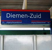
, Diemen
, and Ouder-Amstel
in the Netherlands
. The network is owned by the city of Amsterdam and operated by the Gemeentelijk Vervoerbedrijf
, the company that also operates trams, ferries and local buses.
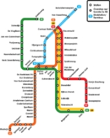
There are four lines in the metro system. Three lines start at Amsterdam Centraal, of which line 53 and 54 connect the city centre to Diemen, Duivendrecht, and Amsterdam Zuidoost
in the southeast, and line 51 connects the city centre to Amstelveen
in the south. The Ring Line, line 50, connects Amsterdam Zuidoost to the west without crossing the centre of the city. The North/South line is currently under construction and will connect the north with Amstelveen and crosses the historical city centre.
The metro system uses standard gauge
track, operating on 750 V DC third rail. Line 51 is a hybrid between metro and light rail
, as it uses shared metro track between Amsterdam Centraal and Zuid, and shared tram track between Zuid and Amstelveen Centrum, continuing with the tram-style overhead
at 600 V DC to Westwijk. Dual height platforms
are provided at the overlapping stops for metro line 51 and tram line 5
vehicles.
The OV-chipkaart
, a contactless smart card, is the only accepted ticket in the Amsterdam Metro. Before August 2009, the nation-wide strippenkaart ticketing system could be used, but it is being phased out.
The expectation was that the metro would be completed around the turn of the century.
 In 1970 the construction of the eastern line was started and it came into operation in 1977. This eastern line consists of two branches, line 53 and 54, to link the city centre with housing developments in the south-east. During the construction, plans to demolish the entire Jewish neighbourhood near the Nieuwmarkt
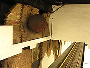
led to strong protests. The metro was still built (wall decorations at the Nieuwmarkt station are dedicated to the protests), but plans to build a highway through the neighbourhood in the centre of Amsterdam were abolished. The line had to be finished by the national government. Due to the protests the planned East-West line was cancelled. At that time however one of the stations that had to connect this line with lines 53 and 54 had already been build underneath Weesperplein station. Because of this the lower level of Weesperplein station was never opened to the public. (Evidence of this lower level however can still be found, for example in the lift buttons.) Since the metro lines, including Weesperplein station, were planned and build during the cold war
, there is also a third section of weesperplein station: a bombshelter, which, fortunately, has never been used as such.
In 1990 line 51 was opened, partially sharing track with the previous metro lines, and new track with the extended tram line 5 to Amstelveen. This is referred to as a 'Sneltram' (fast tram), and was constructed to light rail standards. The changeover between third rail
and overhead power takes place at Zuid.
In 1997 the ring line (50) was added to the system, providing a fast connection between the south and the west, eliminating the necessity of travelling through the city centre.
In 2009, a special city council investigative committee concluded that the municipality of Amsterdam "should never have approved" this project. The digging and building of underground part of the line caused historic buildings to subside and the city's budget deficit to explode. Initially the project was budgeted at €1.4 billion and it should have been finished by 2009. The total costs were re-estimated at around €3 billion and the line would not run until 2017.
The new metro line will be the first to go to the northern Amsterdam district, underneath the IJ
. From there on, it will run, via Central Station to Zuid train station, which is planned to replace Amsterdam Centraal as the city's main transport hub. The project initially had a budget of €1.46 billion, but after several setbacks the total cost estimation has been adjusted to €3.1 billion (price level 2009). The programme has experienced several difficulties, mainly at Centraal Station, resulting in the project running more than 40% over budget. The original planned opening of 2011 has slipped several times, so the current deadline has been contractually agreed upon by all parties, with the construction companies facing fines should the completion date slip any further.
 The tram line to IJburg
in the east was originally planned to be a metro line, and a short tunnel was constructed eastwards from Centraal Station underneath the railway lines towards this goal. As this line was eventually constructed as a tram line, the tunnel had been abandoned, and there are plans to use it as part of a chocolate museum. There are still plans for the tram to IJburg to be upgraded to metro and connect to the nearby city of Almere
, where big new residential areas are being built.
The North/South Line might be extended to Amsterdam Airport Schiphol in the future.
to Amsterdam-Zuidoost, with two branches respectively going to Gaasperplas
(now line 53) and Holendrecht
(now line 54). Spaklerweg
station was completed in carcass, but opened later.
On ctober 11, 1980, both lines were lengthened to Amsterdam Centraal Station, their northern terminus.
The extension of the Gein Line opened on August 27, 1982, with the finishing of the section between Holendrecht and Gein
. Spaklerweg station still opened. In some plans of the Gein Line, there was an extension to Weesp
and Almere
taken into account, however, according to the last Metro Network Study, it seems not to be likely.
to Poortwachter became opened. Even today the line is considered as a fast tram line. On September 13, 2004, an extension to Amstelveen
Westwijk was finished.
Until Amsterdam Zuid Station, line 51 is a full metro line and has no at-grade intersections, takes power from the third rail
and is suitable for 3 meters (10ft) wide trains. The fast tram trains have a width of 2.65 meters (8ft 6in) wide and serves these stations with footboards at the doors of the rolling stock.
Further from Amsterdam Zuid Station, to Amstelveen
, the line goes further as a tram. Only the small-profile trains can drive here and the power comes from overhead lines. On the northern half of this part, another tram line ram line 5 (Amsterdam)|5) serves here too.
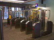 The OV-chipkaart
is the only valid form of ticket on the metro system. It replaced the so-called strippenkaart system on August 27, 2009, after the two systems had run parallel since 2006. New ticket gates have been installed in all enclosed stations, with standalone checkin/checkout machines where platforms are shared with train or tram lines.
 For the signs of the Amsterdam Metro the typeface
M.O.L. is used, which was specially designed for the signs by Gerard Unger
in 1974. The spaces within the letters are larger than normal, in order to improve the letters' legibility when they are illuminated. The name M.O.L. refers to the Dutch
word mol which means mole
in English. There were plans to use a mole as the mascot for the metro, but this was stopped by city authorities.
Rapid transit
A rapid transit, underground, subway, elevated railway, metro or metropolitan railway system is an electric passenger railway in an urban area with a high capacity and frequency, and grade separation from other traffic. Rapid transit systems are typically located either in underground tunnels or on...
and light rail
Light rail
Light rail or light rail transit is a form of urban rail public transportation that generally has a lower capacity and lower speed than heavy rail and metro systems, but higher capacity and higher speed than traditional street-running tram systems...
system in Amsterdam
Amsterdam
Amsterdam is the largest city and the capital of the Netherlands. The current position of Amsterdam as capital city of the Kingdom of the Netherlands is governed by the constitution of August 24, 1815 and its successors. Amsterdam has a population of 783,364 within city limits, an urban population...
, and its surrounding municipalities Amstelveen
Amstelveen
' is a suburban municipality in the Netherlands, in the province of North Holland. It is part of the metropolitan area of Amsterdam. The municipality of Amstelveen consists of the following villages and/or districts: Amstelveen, Bovenkerk, Westwijk, Bankras-Kostverloren, Groenelaan, Waardhuizen,...
, Diemen
Diemen
Diemen is a municipality and a town in the Netherlands with a population of around 24,000. Diemen is located in the province of North Holland directly to the east of Amsterdam within the capital's metropolitan area.-Geography:...
, and Ouder-Amstel
Ouder-Amstel
Ouder-Amstel is a municipality in the Netherlands, in the province of North Holland.-Population centres :The municipality of Ouder-Amstel consists of the following cities, towns, villages and/or districts: Duivendrecht, Ouderkerk aan de Amstel, Waver....
in the Netherlands
Netherlands
The Netherlands is a constituent country of the Kingdom of the Netherlands, located mainly in North-West Europe and with several islands in the Caribbean. Mainland Netherlands borders the North Sea to the north and west, Belgium to the south, and Germany to the east, and shares maritime borders...
. The network is owned by the city of Amsterdam and operated by the Gemeentelijk Vervoerbedrijf
Gemeentelijk Vervoerbedrijf
The Gemeentelijk Vervoerbedrijf is the municipal transport company of Amsterdam. As of 2007, the GVB is an independent corporation wholly owned by the city of Amsterdam.-History:...
, the company that also operates trams, ferries and local buses.
There are four lines in the metro system. Three lines start at Amsterdam Centraal, of which line 53 and 54 connect the city centre to Diemen, Duivendrecht, and Amsterdam Zuidoost
Amsterdam Zuidoost
Amsterdam-Zuidoost is one of fifteen boroughs of the city of Amsterdam. It consists of four residential areas—Bijlmermeer, Venserpolder, Gaasperdam and Driemond—as well as the Amstel III/Bullewijk Business Park and the ArenA Boulevard area.Amsterdam-Zuidoost has approximately 86,000...
in the southeast, and line 51 connects the city centre to Amstelveen
Amstelveen
' is a suburban municipality in the Netherlands, in the province of North Holland. It is part of the metropolitan area of Amsterdam. The municipality of Amstelveen consists of the following villages and/or districts: Amstelveen, Bovenkerk, Westwijk, Bankras-Kostverloren, Groenelaan, Waardhuizen,...
in the south. The Ring Line, line 50, connects Amsterdam Zuidoost to the west without crossing the centre of the city. The North/South line is currently under construction and will connect the north with Amstelveen and crosses the historical city centre.
The metro system uses standard gauge
Standard gauge
The standard gauge is a widely-used track gauge . Approximately 60% of the world's existing railway lines are built to this gauge...
track, operating on 750 V DC third rail. Line 51 is a hybrid between metro and light rail
Light rail
Light rail or light rail transit is a form of urban rail public transportation that generally has a lower capacity and lower speed than heavy rail and metro systems, but higher capacity and higher speed than traditional street-running tram systems...
, as it uses shared metro track between Amsterdam Centraal and Zuid, and shared tram track between Zuid and Amstelveen Centrum, continuing with the tram-style overhead
Overhead lines
Overhead lines or overhead wires are used to transmit electrical energy to trams, trolleybuses or trains at a distance from the energy supply point...
at 600 V DC to Westwijk. Dual height platforms
Railway platform
A railway platform is a section of pathway, alongside rail tracks at a train station, metro station or tram stop, at which passengers may board or alight from trains or trams. Almost all stations for rail transport have some form of platforms, with larger stations having multiple platforms...
are provided at the overlapping stops for metro line 51 and tram line 5
Tram line 5 (Amsterdam)
Tramlijn 5 is a tram route in the capital of the Netherlands, Amsterdam. The route runs between the centre of Amsterdam and the town of Amstelveen, and is operated by the municipal transport company GVB...
vehicles.
The OV-chipkaart
OV-chipkaart
The OV-chipkaart is a contactless smart card system which is in the process of being introduced on all public transport in the Netherlands, including train, metro, tram and bus...
, a contactless smart card, is the only accepted ticket in the Amsterdam Metro. Before August 2009, the nation-wide strippenkaart ticketing system could be used, but it is being phased out.
History
Amsterdam decided on the construction of a metro system in 1968. Four lines were to be built, connecting the entire city and replacing many of the existing tram lines. The following lines were planned:- An east-west line from southeast to Osdorp via the Central Station;
- A ring line of the western harbor area to Diemen;
- A north-south line through the north of Amsterdam Central Station to Weteringplantsoen with two branches at both ends;
- Half east-west line from Geuzenveld to Gaasperplas.
The expectation was that the metro would be completed around the turn of the century.
Nieuwmarkt
Nieuwmarkt is a square in the centre of the Dutch capital Amsterdam. The surrounding area is known as the Nieuwmarktbuurt ....
led to strong protests. The metro was still built (wall decorations at the Nieuwmarkt station are dedicated to the protests), but plans to build a highway through the neighbourhood in the centre of Amsterdam were abolished. The line had to be finished by the national government. Due to the protests the planned East-West line was cancelled. At that time however one of the stations that had to connect this line with lines 53 and 54 had already been build underneath Weesperplein station. Because of this the lower level of Weesperplein station was never opened to the public. (Evidence of this lower level however can still be found, for example in the lift buttons.) Since the metro lines, including Weesperplein station, were planned and build during the cold war
Cold War
The Cold War was the continuing state from roughly 1946 to 1991 of political conflict, military tension, proxy wars, and economic competition between the Communist World—primarily the Soviet Union and its satellite states and allies—and the powers of the Western world, primarily the United States...
, there is also a third section of weesperplein station: a bombshelter, which, fortunately, has never been used as such.
In 1990 line 51 was opened, partially sharing track with the previous metro lines, and new track with the extended tram line 5 to Amstelveen. This is referred to as a 'Sneltram' (fast tram), and was constructed to light rail standards. The changeover between third rail
Third rail
A third rail is a method of providing electric power to a railway train, through a semi-continuous rigid conductor placed alongside or between the rails of a railway track. It is used typically in a mass transit or rapid transit system, which has alignments in its own corridors, fully or almost...
and overhead power takes place at Zuid.
In 1997 the ring line (50) was added to the system, providing a fast connection between the south and the west, eliminating the necessity of travelling through the city centre.
Planned
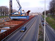
In 2002, the construction of the North/South Line was started, which was due to be completed in July 2012. Due to several setbacks and disputes with the construction company the construction of the line is behind on schedule and it is now scheduled for completion in 2017.In 2009, a special city council investigative committee concluded that the municipality of Amsterdam "should never have approved" this project. The digging and building of underground part of the line caused historic buildings to subside and the city's budget deficit to explode. Initially the project was budgeted at €1.4 billion and it should have been finished by 2009. The total costs were re-estimated at around €3 billion and the line would not run until 2017.
The new metro line will be the first to go to the northern Amsterdam district, underneath the IJ
IJ (bay)
The IJ is a river, formerly a bay, in the Dutch province of North Holland. It is known for being Amsterdam's waterfront. The name derives from the generic Germanic term for "water" and is similar to other Aa/Ee names for bodies of water. In Dutch, the name consists of the digraph ij, which is...
. From there on, it will run, via Central Station to Zuid train station, which is planned to replace Amsterdam Centraal as the city's main transport hub. The project initially had a budget of €1.46 billion, but after several setbacks the total cost estimation has been adjusted to €3.1 billion (price level 2009). The programme has experienced several difficulties, mainly at Centraal Station, resulting in the project running more than 40% over budget. The original planned opening of 2011 has slipped several times, so the current deadline has been contractually agreed upon by all parties, with the construction companies facing fines should the completion date slip any further.
IJburg
IJburg is a residential neighbourhood currently under construction in the east of Amsterdam. It is situated in the IJ Lake and is being built on artificial islands which have been raised from the lake...
in the east was originally planned to be a metro line, and a short tunnel was constructed eastwards from Centraal Station underneath the railway lines towards this goal. As this line was eventually constructed as a tram line, the tunnel had been abandoned, and there are plans to use it as part of a chocolate museum. There are still plans for the tram to IJburg to be upgraded to metro and connect to the nearby city of Almere
Almere
Almere is a planned city and municipality in the province of Flevoland, the Netherlands, bordering Lelystad and Zeewolde. The municipality of Almere comprises the districts Almere Stad, Almere Haven, Almere Buiten, Almere Hout, Almere Poort and Almere Pampus .Almere is the youngest city in the...
, where big new residential areas are being built.
The North/South Line might be extended to Amsterdam Airport Schiphol in the future.
Network
The network consists of four lines and five from 2017. Currently four metro lines in Amsterdam: the Gein Line and Gaasperplas Line (together Oostlijn), the Amstelveen line and Ringlijn. The North / South line is under construction. A total of 52 stations combined: 33 stations and 19 underground subway stations. With the opening of the North / South Line will be added at six stations.| Line | Name | Colour | From/To | Opening | Stations | Passengers (2009) | |
|---|---|---|---|---|---|---|---|
| 50 | Ringlijn | Green | Isolatorweg – Gein | 1997 | 20 | 100 200 | |
| 51 | Amstelveenlijn | Orange | Westwijk – Centraal Station | 1990 | 29 | 60 800 | |
| 52 | Noord/Zuidlijn | Blue | Station Zuid – Buikslotermeerplein | 2017 (?) | 8 | - | |
| 53 | Gaasperplaslijn | Red | Gaasperplas – Centraal Station | 1977 | 14 | 60 600 | |
| 54 | Geinlijn | Yellow | Gein – Centraal Station | 1977 | 15 | 73 500 |
Oostlijn
On October 14, 1977, the first metro line ran from WeesperpleinWeesperplein metro station
Weesperplein is an Amsterdam Metro station just south of the centre of Amsterdam, The Netherlands.-The Station:The station opened in 1977 and is served by 3 lines, the 51 , 53 and 54 .The station was opened as a temporary terminus for the metro services before the extension to central...
to Amsterdam-Zuidoost, with two branches respectively going to Gaasperplas
Gaasperplas
Gaasperplas is an artificial lake used for recreational purposes south-east of Amsterdam in the Netherlands.Gaasperplas was created with the extraction of sand for the construction of the Bijlmer. At its deepest the lake is 35 metres deep...
(now line 53) and Holendrecht
Amsterdam Holendrecht railway station
Amsterdam Holendrecht is a railway station, in Amsterdam Zuidoost , the Netherlands.The station opened on 14 December 2008. Before that date Holendrecht was just a Metro station on the Amsterdam Metro network. The station was opened on 16 October 1977 as a metro station and is now served by two...
(now line 54). Spaklerweg
Spaklerweg metro station
Spaklerweg is an Amsterdam Metro station in the industrial area Overamstel of Amsterdam, The Netherlands. The station opened in 1982 and is served by 3 lines, the 51 , 53 and 54 .The metro station is only accessible with an OV-chipkaart or GVB Travel Pass.Change at this station between...
station was completed in carcass, but opened later.
On ctober 11, 1980, both lines were lengthened to Amsterdam Centraal Station, their northern terminus.
The extension of the Gein Line opened on August 27, 1982, with the finishing of the section between Holendrecht and Gein
Gein metro station
Gein is an Amsterdam Metro station in the Gaasperdam area of Amsterdam, The Netherlands. The station opened in 1982 and is served by 2 lines, the 50 and 54 ....
. Spaklerweg station still opened. In some plans of the Gein Line, there was an extension to Weesp
Weesp
Weesp is a town and a municipality in the Netherlands, in the province of North Holland. It has a population of 17,533 .Weesp lies next to the rivers de Vecht and Smal Weesp and also next to the Amsterdam-Rhine Canal. It is in an area called the "Vechtstreek"...
and Almere
Almere
Almere is a planned city and municipality in the province of Flevoland, the Netherlands, bordering Lelystad and Zeewolde. The municipality of Almere comprises the districts Almere Stad, Almere Haven, Almere Buiten, Almere Hout, Almere Poort and Almere Pampus .Almere is the youngest city in the...
taken into account, however, according to the last Metro Network Study, it seems not to be likely.
Amstelveenlijn
The next expansion got, in following to the Nieuwmarkt Riots in 1975, the format of a fast tram connection rather than a full metro. On December 1, 1990 line 51 from SpaklerwegSpaklerweg metro station
Spaklerweg is an Amsterdam Metro station in the industrial area Overamstel of Amsterdam, The Netherlands. The station opened in 1982 and is served by 3 lines, the 51 , 53 and 54 .The metro station is only accessible with an OV-chipkaart or GVB Travel Pass.Change at this station between...
to Poortwachter became opened. Even today the line is considered as a fast tram line. On September 13, 2004, an extension to Amstelveen
Amstelveen
' is a suburban municipality in the Netherlands, in the province of North Holland. It is part of the metropolitan area of Amsterdam. The municipality of Amstelveen consists of the following villages and/or districts: Amstelveen, Bovenkerk, Westwijk, Bankras-Kostverloren, Groenelaan, Waardhuizen,...
Westwijk was finished.
Until Amsterdam Zuid Station, line 51 is a full metro line and has no at-grade intersections, takes power from the third rail
Third rail
A third rail is a method of providing electric power to a railway train, through a semi-continuous rigid conductor placed alongside or between the rails of a railway track. It is used typically in a mass transit or rapid transit system, which has alignments in its own corridors, fully or almost...
and is suitable for 3 meters (10ft) wide trains. The fast tram trains have a width of 2.65 meters (8ft 6in) wide and serves these stations with footboards at the doors of the rolling stock.
Further from Amsterdam Zuid Station, to Amstelveen
Amstelveen
' is a suburban municipality in the Netherlands, in the province of North Holland. It is part of the metropolitan area of Amsterdam. The municipality of Amstelveen consists of the following villages and/or districts: Amstelveen, Bovenkerk, Westwijk, Bankras-Kostverloren, Groenelaan, Waardhuizen,...
, the line goes further as a tram. Only the small-profile trains can drive here and the power comes from overhead lines. On the northern half of this part, another tram line ram line 5 (Amsterdam)|5) serves here too.
Vehicles
There are 106 two-car vehicles for the Amsterdam Metro:| Vehicle | Type | Description |
|---|---|---|
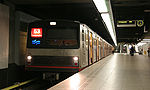 |
Two-car metro unit for line 50,53,54 (44) |
Length: 37.5 m Width: 3.0 m Weight (fully loaded): 54.0 tonnes (75.0 tonnes) Maximum speed: 70 km/h Power: 4 x 195 kW DC power supply: 750 volts |
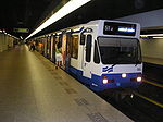 |
Light-rail unit for line 51 (25) |
Length: 30.6 m Width: 2.65 m Weight (fully loaded): 48.5 tonnes (72.0 tonnes) Maximum speed: 70 km/h Power: 6 x 77 kW DC power supply: 600/750 volts |
 |
Ring Line unit for line 50 and 51. (37) |
Length: 30.9 m Width: 2.7 m Weight (fully loaded): 48.0 tonnes (72.0 tonnes) Maximum speed: 70 km/h Power: 6 x 70 kW DC power supply: 750 volts |
Ticket system
OV-chipkaart
The OV-chipkaart is a contactless smart card system which is in the process of being introduced on all public transport in the Netherlands, including train, metro, tram and bus...
is the only valid form of ticket on the metro system. It replaced the so-called strippenkaart system on August 27, 2009, after the two systems had run parallel since 2006. New ticket gates have been installed in all enclosed stations, with standalone checkin/checkout machines where platforms are shared with train or tram lines.
Graphic design
Typeface
In typography, a typeface is the artistic representation or interpretation of characters; it is the way the type looks. Each type is designed and there are thousands of different typefaces in existence, with new ones being developed constantly....
M.O.L. is used, which was specially designed for the signs by Gerard Unger
Gerard Unger
Gerard Unger is a graphic and type designer. He studied at the Gerrit Rietveld Academie in Amsterdam from 1963-67, and subsequently worked at Total Design, Prad and Joh. Enschedé. In 1975, he established himself as an independent developer...
in 1974. The spaces within the letters are larger than normal, in order to improve the letters' legibility when they are illuminated. The name M.O.L. refers to the Dutch
Dutch language
Dutch is a West Germanic language and the native language of the majority of the population of the Netherlands, Belgium, and Suriname, the three member states of the Dutch Language Union. Most speakers live in the European Union, where it is a first language for about 23 million and a second...
word mol which means mole
Mole (animal)
Moles are small cylindrical mammals adapted to a subterranean lifestyle. They have velvety fur; tiny or invisible ears and eyes; and short, powerful limbs with large paws oriented for digging. The term is especially and most properly used for the true moles, those of the Talpidae family in the...
in English. There were plans to use a mole as the mascot for the metro, but this was stopped by city authorities.
External links
- Metro map at the Gemeentelijk VervoerbedrijfGemeentelijk VervoerbedrijfThe Gemeentelijk Vervoerbedrijf is the municipal transport company of Amsterdam. As of 2007, the GVB is an independent corporation wholly owned by the city of Amsterdam.-History:...
website - Official Website (In Dutch and English)