
Ambrose Light
Encyclopedia
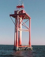
Ambrose Light, often called Ambrose Tower, was a light station at the convergence of several major shipping lanes in Lower New York Bay
, including Ambrose Channel
, the primary passage for ships entering and departing the Port of New York and New Jersey
.
The tower, which was owned and maintained by the United States Coast Guard
, was located at 40.46°N 73.83°W.
On July 25, 2008, the Coast Guard announced that Ambrose Light, which was severely damaged when a tanker struck it on November 3, 2007, would be dismantled.
The removal work was done by Costello Dismantling Co. in September 2008. The tugboats Sea Wolf, Sea Bear and Miss Yvette helped out. The Coast Guard has replaced the light with flashing buoys.
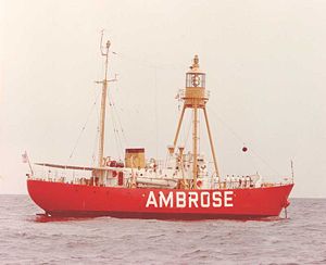
 The Lightship Ambrose
held its station from 1823 until its replacement in 1967, and was only the fourth lightship designed and commissioned to serve a U.S. coastal port.
The original light station was put into operation on August 23, 1967, replacing the obsolete Lightship Ambrose
, and cost $2.4 million. The tower design was a Texas Tower
, a very strong steel pipe structure based on the oil platform
s built for use in the Gulf of Mexico
. The structure was prefabricated in Norfolk, Virginia
and shipped in sections on barges for assembly on-site. The tower station was situated about 7.5 miles (12.1 km) off of the coast of Sandy Hook, New Jersey
in approximately 70 feet (21.3 m) of water and was supported by four 42 inches (1,066.8 mm) steel pipes, sunk down about 245 feet (74.7 m) to the bedrock. The light was about 136 feet (41.5 m) above mean low water and the 10,000,000 candle-power light could be seen for 18 miles (29 km).
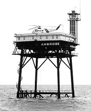
The lower deck was designed for fuel and water storage while the top deck served as living quarters for a 6 to 9 man crew. The roof of the platform also served as a flight deck for helicopters, the main mode of transport to and from the station for crew rotations. The tower was automated and the crew was removed from duty on October 15, 1988. Ambrose light station was controlled electronically by the United States Coast Guard
station on Governors Island
until the island and base were transferred to New York State and City for $1 in 2003.
In October 1996, on a clear night the 754 feet (229.8 m) Greek oil tanker Aegeo struck the tower, causing severe damage. It was discovered that the light was not functioning when the tanker hit the tower. The Aegeo's captain was later found to be at fault. Three years later, in September 1999 after repairs were deemed insufficient, the old structure was razed by the U.S. Army Corps of Engineers and replaced with a new tower. The new tower was built about 1.5 miles (2.4 km) east of the old site, and is approximately 76 feet (23.2 m) above mean low water, and the 60,000 candle-power light is visible for 18 miles (29 km).
In January 2001, the 492 feet (150 m) Maltese freighter Kouros V struck the new tower, shortly after the repairs from the previous incident had been completed. This time, the tower suffered extensive damage, and the light was rendered inoperable. A temporary lighted buoy was set by the Coast Guard on November 7.
On July 25, 2008, the Coast Guard announced the deconstruction of Ambrose Light would begin on July 28, 2008.
The tower carried NOAA's National Data Buoy Center automated weather station ALSN6, which was of interest to scuba divers, fishermen, and other small craft users. The tower was a staging point for pilot ships, notably the Sandy Hook Pilots.
Lower New York Bay
Lower New York Bay is that section of New York Bay south of the Narrows, the relatively narrow strait between the shores of Staten Island and Brooklyn. The southern end of the bay opens directly to the Atlantic Ocean between two spits of land, Sandy Hook, New Jersey, and Rockaway, Queens, on Long...
, including Ambrose Channel
Ambrose Channel
Ambrose Channel is the main shipping channel in and out of the Port of New York and New Jersey. The channel is considered to be part of Lower New York Bay and is located several miles off the coasts of Sandy Hook in New Jersey and Breezy Point, Queens in New York...
, the primary passage for ships entering and departing the Port of New York and New Jersey
Port of New York and New Jersey
The Port of New York and New Jersey comprises the waterways in the estuary of the New York-Newark metropolitan area with a port district encompassing an approximate area within a radius of the Statue of Liberty National Monument...
.
The tower, which was owned and maintained by the United States Coast Guard
United States Coast Guard
The United States Coast Guard is a branch of the United States Armed Forces and one of the seven U.S. uniformed services. The Coast Guard is a maritime, military, multi-mission service unique among the military branches for having a maritime law enforcement mission and a federal regulatory agency...
, was located at 40.46°N 73.83°W.
On July 25, 2008, the Coast Guard announced that Ambrose Light, which was severely damaged when a tanker struck it on November 3, 2007, would be dismantled.
The removal work was done by Costello Dismantling Co. in September 2008. The tugboats Sea Wolf, Sea Bear and Miss Yvette helped out. The Coast Guard has replaced the light with flashing buoys.
History
Lightship Ambrose
Lightship Ambrose was the name given to multiple lightships that served as the sentinel beacon marking Ambrose Channel which is the main shipping channel for New York Harbor....
held its station from 1823 until its replacement in 1967, and was only the fourth lightship designed and commissioned to serve a U.S. coastal port.
The original light station was put into operation on August 23, 1967, replacing the obsolete Lightship Ambrose
Lightship Ambrose
Lightship Ambrose was the name given to multiple lightships that served as the sentinel beacon marking Ambrose Channel which is the main shipping channel for New York Harbor....
, and cost $2.4 million. The tower design was a Texas Tower
Texas Tower (lighthouse)
A Texas Tower lighthouse is a structure, similar to an off-shore oil platform, used as a platform for a lighthouse.-Examples:The first example in the United States was the Buzzards Bay Light, located in Buzzards Bay, Massachusetts, and commissioned on November 1, 1961...
, a very strong steel pipe structure based on the oil platform
Oil platform
An oil platform, also referred to as an offshore platform or, somewhat incorrectly, oil rig, is a lаrge structure with facilities to drill wells, to extract and process oil and natural gas, and to temporarily store product until it can be brought to shore for refining and marketing...
s built for use in the Gulf of Mexico
Gulf of Mexico
The Gulf of Mexico is a partially landlocked ocean basin largely surrounded by the North American continent and the island of Cuba. It is bounded on the northeast, north and northwest by the Gulf Coast of the United States, on the southwest and south by Mexico, and on the southeast by Cuba. In...
. The structure was prefabricated in Norfolk, Virginia
Norfolk, Virginia
Norfolk is an independent city in the Commonwealth of Virginia in the United States. With a population of 242,803 as of the 2010 Census, it is Virginia's second-largest city behind neighboring Virginia Beach....
and shipped in sections on barges for assembly on-site. The tower station was situated about 7.5 miles (12.1 km) off of the coast of Sandy Hook, New Jersey
Sandy Hook, New Jersey
Sandy Hook is a barrier spit, approximately 6.0 miles in length and varying between 0.10 and 1 miles wide in Middletown Township in Monmouth County, along the Atlantic Ocean coast of eastern New Jersey in the United States. The barrier spit encloses the southern entrance of Lower New York Bay...
in approximately 70 feet (21.3 m) of water and was supported by four 42 inches (1,066.8 mm) steel pipes, sunk down about 245 feet (74.7 m) to the bedrock. The light was about 136 feet (41.5 m) above mean low water and the 10,000,000 candle-power light could be seen for 18 miles (29 km).
The lower deck was designed for fuel and water storage while the top deck served as living quarters for a 6 to 9 man crew. The roof of the platform also served as a flight deck for helicopters, the main mode of transport to and from the station for crew rotations. The tower was automated and the crew was removed from duty on October 15, 1988. Ambrose light station was controlled electronically by the United States Coast Guard
United States Coast Guard
The United States Coast Guard is a branch of the United States Armed Forces and one of the seven U.S. uniformed services. The Coast Guard is a maritime, military, multi-mission service unique among the military branches for having a maritime law enforcement mission and a federal regulatory agency...
station on Governors Island
Governors Island
Governors Island is a island in Upper New York Bay, approximately one-half mile from the southern tip of Manhattan Island and separated from Brooklyn by Buttermilk Channel. It is legally part of the borough of Manhattan in New York City...
until the island and base were transferred to New York State and City for $1 in 2003.
In October 1996, on a clear night the 754 feet (229.8 m) Greek oil tanker Aegeo struck the tower, causing severe damage. It was discovered that the light was not functioning when the tanker hit the tower. The Aegeo's captain was later found to be at fault. Three years later, in September 1999 after repairs were deemed insufficient, the old structure was razed by the U.S. Army Corps of Engineers and replaced with a new tower. The new tower was built about 1.5 miles (2.4 km) east of the old site, and is approximately 76 feet (23.2 m) above mean low water, and the 60,000 candle-power light is visible for 18 miles (29 km).
In January 2001, the 492 feet (150 m) Maltese freighter Kouros V struck the new tower, shortly after the repairs from the previous incident had been completed. This time, the tower suffered extensive damage, and the light was rendered inoperable. A temporary lighted buoy was set by the Coast Guard on November 7.
On July 25, 2008, the Coast Guard announced the deconstruction of Ambrose Light would begin on July 28, 2008.
The tower carried NOAA's National Data Buoy Center automated weather station ALSN6, which was of interest to scuba divers, fishermen, and other small craft users. The tower was a staging point for pilot ships, notably the Sandy Hook Pilots.
External links
- Lighthouse Depot - Story about destruction of original structure
- Night Beacon - About lightships, including Ambrose Lightship
- South Street Seaport Museum - Current location of the Ambrose Lightship
- New Jersey Scuba Diver - Information, charts, and history of Ambrose light station