

Algoman orogeny
Encyclopedia
During the Late Archaen Eon repeated episodes of continental collision
s, compressions and subduction
s generated a mountain-building episode known as the Algoman orogeny
; it is known as the Kenoran orogeny in Canada. The Superior province and the Minnesota River Valley microcontinent collided about 2,700 to 2,500 million years ago. The collision folded the Earth's crust, and produced enough heat and pressure to metamorphize
then-existing rock. This orogeny added landmass along a 1200 km (745.6 mi) boundary that stretches discontinuously from present-day eastern South Dakota into the Lake Huron area. The Algoman orogeny brought the Archaen Eon to a close, about ; it lasted less than 100 million years and marks a major change in the development of the earth’s crust. Prior to the orogeny thousands of feet of sedimentary layers had been laid down and they were metamorphosed by the heat and pressure.
The Canadian shield
contains belts of volcanic and belts of sedimentary rocks. The areas between individual belts consist of granite
s or granitic gneisses which form fault zones. These two types of belts can be seen in the Wabigoon, Quetico and Wawa subprovince
s; the Wabigoon and Wawa are of volcanic origin and the Quetico is of sedimentary origin. These three subprovinces lie linearly in southwestern- to northeastern-oriented belts about 140 km (87 mi) wide on the southern portion of the Superior Province.
The Slave province and portions of the Nain province
were also affected. In the past billions of years microcontinents, subprovinces, provinces and other land masses have floated around on top of the mantle – assembling, breaking apart and reassembling. New radiometic dating data and detrital zircon geochronology data indicate that the 2,000- to 1,700-million-year-old amalgamation of the Slave, Superior, Sask, Wyoming and Nain cratons were part of the Kenorland supercontinent.
, Kewaunee County, Wisconsin
); it is known as the Kenoran orogeny in Canada. This volcanism, intrusion, metamorphism, folding and faulting probably occurred in a time span of 50 to 100 million years, or 2,700±50 My.
The Algoman orogeny extended in a line roughly 1,200 kilometers long from the middle of South Dakota
, east through the middle of the Upper Peninsula of Michigan
, into the Sudbury, Ontario, region. This boundary is the 50 km (31.1 mi) wide Great Lakes tectonic zone
(GLTZ) which remains slightly active today. Rift
ing in the GLTZ began about at the end of the Algoman orogeny.
This uplift of the Earth's surface affected Precambrian
rocks of northern Minnesota and adjacent Ontario, in the Superior province. The Algoman event that deformed and metamorphosed the Superior, Slave and the eastern part of the Nain provinces appears to have affected a far wider area than subsequent orogenies. It is the earliest datable orogeny in North America, and brought the Archean Eon to a close, about . The end of the Archean Eon marks a major change in the development of the Earth’s crust
– the crust was essentially formed – which achieved crustal thickness of about 40 km (24.9 mi) under the continents.
 The Superior province and the large Minnesota River Valley gneissic microcontinent collided about 2,700 to 2,500 million years ago. The collision folded the Earth's crust, and produced enough heat and pressure to metamorphize then-existing rock. Repeated continental collisions, north-south directed compression and subduction resulted in the uprising of the Algoman Mountains. This was followed by intrusions of granitic pluton
s; many granitic batholithic domes cooled within the gneiss
es about —two examples are the Sacred Heart granite of southwestern Minnesota and the Watersmeet Domes metagabbros which straddle the Wisconsin – Michigan's Upper Peninsula border. After the granitic intrusions solidified into batholith
ic domes, the greenstone-granite terrane
was subjected to new stresses that caused movement horizontally along several faults and huge blocks of the crust were moved vertically relative to adjacent blocks. This combination of folding, intrusion and faulting built mountain ranges throughout northern Minnesota, northern Wisconsin, Michigan's Upper Peninsula and southernmost Ontario. Magma
s and high-grade metamorphic rocks are associated with the orogeny.
By extrapolating the now-eroded and tilted beds upward, it has been determined that these mountains were several kilometers high. Similar projections of the tilted beds downward, coupled with geophysical measurements on the greenstone belts in Canada, suggest the metavolcanic and metasedimentary rocks of the belts project downward at least a few kilometers.
, epidote
and actinolite
that formed during metamorphism. After metamorphism occurred, these rocks were folded and faulted into a system of mountains by the Algoman orogeny. Most Archean volcanic rocks are concentrated within greenstone belts, which are long linear belts of dominated by volcanic rocks which are surrounded by granitoid rocks.
These volcanic beds are 8 to 9 km (26,246.7 to 29,527.6 ft) thick. About the greenstone
-granite terrane was subjected to new stresses that caused movement along several faults. Faulting on both small and large scales is typical of greenstone belt deformation. These faults show both vertical and horizontal movement relative to adjacent blocks. Large-scale faults typically occur along the margins of the greenstone belts where they are in contact with enclosed granitic rocks. Vertical movement may be thousands of meters and horizontal movements of many kilometers occur along some fault zones.
Sometime before masses of magma intruded under and within the igneous and sedimentary rocks, heating and pressing the rocks to metamorphose them into hard greenish greenstones. They begin with fissure eruptions
of basalt
, continued with intermediate and felsic
rocks erupted from volcanic centers with and ended with sediments from the erosion of the volcanic pile. The rising magma was extruded under a shallow ancient sea where it underwent subaqueous cooling to form pillowed greenstones. Some of Minnesota’s pillows probably cooled at depths as great a 1000 m (3,280.8 ft); these deep-cooled pillows contain no gas cavities or vesicles.
Most greenstone belts, with all of their components, have been folded into troughlike synclines; the original basaltic rock, which was on the bottom, occurs on the outer margins of the trough. The overlying, younger rock units – rhyolite
s and greywackes – occur closer to the center of the syncline. The rocks are so intensely folded that most have been tilted nearly 90°, with the tops of layers on one side of the synclinal belt facing those on the other side; the rock sequences are in effect lying on their sides. The folding can be so complex that a single layer may be brought to the surface many times.
s and mudstone
s of the Knife Lake and Lake Vermilion formations. Greywackes are poorly sorted mixtures of clay, mica
and quartz
which are derived from the decomposition of pyroclastic debris; this debris suggests that some explosive volcanic activity occurred in the area during Precambrian times. The volcanism took place on the surface and the other deformations took place at various depths. Numerous earthquakes accompanied the volcanism and faulting.
The Superior province forms the core of both the North American continent and the Canadian shield, and has a thickness of at least 250 km (155.3 mi). The granites of the Canadian shield date from 2,700 to 2,500 million years ago. In general the Superior province consists of east-west trending belts of predominately volcanic rocks alternating with belts of sedimentary and gneissic rocks.
Due to down warping along elongate zones, each belt is essentially a large downfold or downfaulted block. The areas between individual belts are fault zones consisting of granite or granitic gneiss. Its western part contains a regional pattern of east-west trending 100 to 200 km (62.1 to 124.3 mi) wide granitic greenstone and metasedimentary belts (subprovinces). Western Superior province's mantle has remained intact since the 2,700-million-year-ago accretion of the subprovinces.
Both folding and faulting can be seen in the Wabigoon, Quetico and Wawa subprovinces. These three subprovinces lie linearly in southwestern- to northeastern-oriented belts of about 140 km (87 mi) wide.
The Wabigoon subprovince lies north of the Quetico subprovince, and is wider than the other two subprovinces. It begins more north than the Quetico subprovince in north-central Minnesota, with its western side extending up into Ontario. The Wabigoon subprovince continues northeasterly into central Ontario; it is partially interrupted by the Southern province.
The Quetico subprovince lies north of the Wawa subprovince. It begins in north-central Minnesota, and continues northeastly into Ontario. It is completely interrupted by a narrow band of the 1,100- to 1,550-million-year-old Southern province to the northeast of Thunder Bay.
The Wawa subprovince is the most southerly of the three; it begins in central Minnesota, U.S., continues northeast to Thunder Bay, Ontario, Canada, (where its southern border just skims north Thunder Bay) and then extends east beyond Lake Superior. The northern boundary continues in a roughly northeasterly heading, while the southern border dips south to follow the northeast shore of Lake Superior.
The boundary between the Wabigoon and Quetico subprovinces seems to have been also controlled by colliding plates and subsequent transpressions. This Rainy Lake – Seine River fault zone is a major northeast-southwest trending strike-slip fault zone; it trends N80°E to cut through the northwest part of Voyageurs National Park in Minnesota and extends westward to the International Falls, Minnesota, U.S. – Fort Frances, Ontario, area. The fault has transported rocks in the greenstone belt a considerable distance from their origin. The greenstone belt is 2 to 3 km (1.2 to 1.9 mi) wide at the Seven Sisters Islands; to the west the greenstone interfingers with pods of anorthositic gabbro. Radiometric dating from the Rainy Lake area in Ontario show an age of about 2,700 million years old, which favors a moving tectonic plate model the formation of the boundary.
The largest fault is the Vermilion fault, and it separates the Quetico and Wawa subprovinces with a N40°E trending and was caused by the introduction of masses of magma. The Vermilion fault can be traced westward to North Dakota. It has had a 19 km (12 mi) horizontal movement with the northern block moving eastward and upward relative to the southern block. The rocks north of the fault are part of the gneissic Quetico subprovince and those to the south are part of the Wawa subprovince. The junction between the Quetico and Wawa subprovinces has zone of biotite-rich migmatite; migmatite is a rock which has characteristics of both igneous and metamorphic processes, this indicates a zone of partial melting which is possible only under high temperature and pressure conditions. It is visible as a 500 m (1,640.4 ft) wide belt. Most of the flattened large crystals in the fault indicate a simple compression rather than a wrenching, shearing or rotational event as the two subprovinces docked. This evidence shows the probability that the Quetico and Wawa subprovinces were joined by the collision of two continental plates, about . Structures in the migmatite
include folds and foliations; the foliations cut across both limbs of earlier-phase folds. These cutting-across foliations indicate that the migmatite has undergone at least two periods of ductile deformation.
s and gneisses produced by intense metamorphism of greywackes and minor amounts of other sedimentary rocks. The sediments, alkalic plutons and felsic
plutons are aged from 2,690 to 2,680 million years. The belt is characterized by relatively low-grade metamorphism on the margins with high-grade metamorphism in the central part. The low-grade metamorphic components of the greywackes were derived primarily from volcanic rocks; the high-grade metamorphic rocks are coarser-grained and contain minerals that reflect higher temperatures. The granitic intrusions within the high-grade metasediments were produced by subduction of the ocean crust and partial melting of metasedimentary rocks. Immediately south of Voyageurs National Park and extending to the Vermilion fault is a broad transition zone that contains migmatite.
The Quetico gneiss belt represents an accretionary wedge that formed in a trench during the collision of several island arc
s (greenstone belts). Boundaries between the gneiss belt and the flanking greenstone belts to the north and south are major fault zones,
the Vermilion and Rainy Lake – Seine River fault zones.
The predominate rock type is a white, coarse-grained, foliated hornblende
tonalite. Minerals in the tonalite
are quartz, plagioclase, alkali feldspar and hornblende.
Geochronology of several Archean rock units establishes a sequence of events, approximately 75 million years in duration, leading to the formation of a new crustal segment. The oldest rocks, at 2,650 million years old, are basic metavolcanics with largely calc-alkaline characteristics. Radiometric dating indicates ages of 2,640 to 2,620 million years are recorded for the syn-kinematic quartz diorite
batholiths and 2,590 to 2,100 million years for the major late-kinematic bodies. Pegmatitic
adamellites, at 2,575±25 million years, are the youngest plutonic units.
Metagreywackes and metapelite
s from two areas traversing one of these aureoles near Yellowknife have been studied. Most of the Slave province rocks are granitic with metamorphosed Yellowknife metasedimentary and volcanic rocks. Isotopic ages of these rocks is around , the time of the Kenoran orogeny. Rocks comprising the Slave province represent a high grade of metamorphism, intrusion and besement remobilization typical of Archean terranes. Migmatites, batholithic intrusive and granulitic metamorphic rocks show foliation and compositional banding; the rocks are uniformly hard and so thoroughly deformed that little foliation exists. Most Yellowknife Supergroup metasediments are tightly folded (isoclinal) or occur in plunging anticlines.
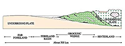
Continental collision
Continental collision is a phenomenon of the plate tectonics of Earth that occurs at convergent boundaries. Continental collision is a variation on the fundamental process of subduction, whereby the subduction zone is destroyed, mountains produced, and two continents sutured together...
s, compressions and subduction
Subduction
In geology, subduction is the process that takes place at convergent boundaries by which one tectonic plate moves under another tectonic plate, sinking into the Earth's mantle, as the plates converge. These 3D regions of mantle downwellings are known as "Subduction Zones"...
s generated a mountain-building episode known as the Algoman orogeny
Orogeny
Orogeny refers to forces and events leading to a severe structural deformation of the Earth's crust due to the engagement of tectonic plates. Response to such engagement results in the formation of long tracts of highly deformed rock called orogens or orogenic belts...
; it is known as the Kenoran orogeny in Canada. The Superior province and the Minnesota River Valley microcontinent collided about 2,700 to 2,500 million years ago. The collision folded the Earth's crust, and produced enough heat and pressure to metamorphize
Metamorphism
Metamorphism is the solid-state recrystallization of pre-existing rocks due to changes in physical and chemical conditions, primarily heat, pressure, and the introduction of chemically active fluids. Mineralogical, chemical and crystallographic changes can occur during this process...
then-existing rock. This orogeny added landmass along a 1200 km (745.6 mi) boundary that stretches discontinuously from present-day eastern South Dakota into the Lake Huron area. The Algoman orogeny brought the Archaen Eon to a close, about ; it lasted less than 100 million years and marks a major change in the development of the earth’s crust. Prior to the orogeny thousands of feet of sedimentary layers had been laid down and they were metamorphosed by the heat and pressure.
The Canadian shield
Canadian Shield
The Canadian Shield, also called the Laurentian Plateau, or Bouclier Canadien , is a vast geological shield covered by a thin layer of soil that forms the nucleus of the North American or Laurentia craton. It is an area mostly composed of igneous rock which relates to its long volcanic history...
contains belts of volcanic and belts of sedimentary rocks. The areas between individual belts consist of granite
Granite
Granite is a common and widely occurring type of intrusive, felsic, igneous rock. Granite usually has a medium- to coarse-grained texture. Occasionally some individual crystals are larger than the groundmass, in which case the texture is known as porphyritic. A granitic rock with a porphyritic...
s or granitic gneisses which form fault zones. These two types of belts can be seen in the Wabigoon, Quetico and Wawa subprovince
Geologic province
A geologic or geomorphic province is a spatial entity with common geologic or geomorphic attributes. A province may include a single dominant structural element such as a basin or a fold belt, or a number of contiguous related elements...
s; the Wabigoon and Wawa are of volcanic origin and the Quetico is of sedimentary origin. These three subprovinces lie linearly in southwestern- to northeastern-oriented belts about 140 km (87 mi) wide on the southern portion of the Superior Province.
The Slave province and portions of the Nain province
Nain province
In Labrador, Canada, the North Atlantic craton is known as the Nain province. The Nain geologic province was intruded by the Nain Plutonic Suite which divides the province into the northern Saglek block and the southern Hopedale block....
were also affected. In the past billions of years microcontinents, subprovinces, provinces and other land masses have floated around on top of the mantle – assembling, breaking apart and reassembling. New radiometic dating data and detrital zircon geochronology data indicate that the 2,000- to 1,700-million-year-old amalgamation of the Slave, Superior, Sask, Wyoming and Nain cratons were part of the Kenorland supercontinent.
Age, names and location
During the Late Archean time (2,800 to 2,500 million years ago) was the mountain-building episode known as the Algoman orogeny (named for AlgomaAlgoma, Wisconsin
Algoma is a city in Kewaunee County in the U.S. state of Wisconsin. The population was 3,357 at the 2000 census. Algoma is part of the Green Bay Metropolitan Statistical Area.-Geography:...
, Kewaunee County, Wisconsin
Kewaunee County, Wisconsin
Kewaunee County is a county located in the U.S. state of Wisconsin. As of 2000, the population was 20,187. Its county seat is Kewaunee. Kewaunee County is part of the Green Bay Metropolitan Statistical Area.-Geography:According to the U.S...
); it is known as the Kenoran orogeny in Canada. This volcanism, intrusion, metamorphism, folding and faulting probably occurred in a time span of 50 to 100 million years, or 2,700±50 My.
The Algoman orogeny extended in a line roughly 1,200 kilometers long from the middle of South Dakota
South Dakota
South Dakota is a state located in the Midwestern region of the United States. It is named after the Lakota and Dakota Sioux American Indian tribes. Once a part of Dakota Territory, South Dakota became a state on November 2, 1889. The state has an area of and an estimated population of just over...
, east through the middle of the Upper Peninsula of Michigan
Upper Peninsula of Michigan
The Upper Peninsula of Michigan is the northern of the two major land masses that make up the U.S. state of Michigan. It is commonly referred to as the Upper Peninsula, the U.P., or Upper Michigan. It is also known as the land "above the Bridge" linking the two peninsulas. The peninsula is bounded...
, into the Sudbury, Ontario, region. This boundary is the 50 km (31.1 mi) wide Great Lakes tectonic zone
Great Lakes tectonic zone
During the Late Archean Eon the Algoman orogeny added landmass to the Superior province by volcanic activity and continental collision along a boundary that stretches from present-day South Dakota, U.S., into the Sudbury, Ontario, Canada, Lake Huron region....
(GLTZ) which remains slightly active today. Rift
Rift
In geology, a rift or chasm is a place where the Earth's crust and lithosphere are being pulled apart and is an example of extensional tectonics....
ing in the GLTZ began about at the end of the Algoman orogeny.
This uplift of the Earth's surface affected Precambrian
Precambrian
The Precambrian is the name which describes the large span of time in Earth's history before the current Phanerozoic Eon, and is a Supereon divided into several eons of the geologic time scale...
rocks of northern Minnesota and adjacent Ontario, in the Superior province. The Algoman event that deformed and metamorphosed the Superior, Slave and the eastern part of the Nain provinces appears to have affected a far wider area than subsequent orogenies. It is the earliest datable orogeny in North America, and brought the Archean Eon to a close, about . The end of the Archean Eon marks a major change in the development of the Earth’s crust
Crust (geology)
In geology, the crust is the outermost solid shell of a rocky planet or natural satellite, which is chemically distinct from the underlying mantle...
– the crust was essentially formed – which achieved crustal thickness of about 40 km (24.9 mi) under the continents.
Formation
Pluton
A pluton in geology is a body of intrusive igneous rock that crystallized from magma slowly cooling below the surface of the Earth. Plutons include batholiths, dikes, sills, laccoliths, lopoliths, and other igneous bodies...
s; many granitic batholithic domes cooled within the gneiss
Gneiss
Gneiss is a common and widely distributed type of rock formed by high-grade regional metamorphic processes from pre-existing formations that were originally either igneous or sedimentary rocks.-Etymology:...
es about —two examples are the Sacred Heart granite of southwestern Minnesota and the Watersmeet Domes metagabbros which straddle the Wisconsin – Michigan's Upper Peninsula border. After the granitic intrusions solidified into batholith
Batholith
A batholith is a large emplacement of igneous intrusive rock that forms from cooled magma deep in the Earth's crust...
ic domes, the greenstone-granite terrane
Terrane
A terrane in geology is short-hand term for a tectonostratigraphic terrane, which is a fragment of crustal material formed on, or broken off from, one tectonic plate and accreted or "sutured" to crust lying on another plate...
was subjected to new stresses that caused movement horizontally along several faults and huge blocks of the crust were moved vertically relative to adjacent blocks. This combination of folding, intrusion and faulting built mountain ranges throughout northern Minnesota, northern Wisconsin, Michigan's Upper Peninsula and southernmost Ontario. Magma
Magma
Magma is a mixture of molten rock, volatiles and solids that is found beneath the surface of the Earth, and is expected to exist on other terrestrial planets. Besides molten rock, magma may also contain suspended crystals and dissolved gas and sometimes also gas bubbles. Magma often collects in...
s and high-grade metamorphic rocks are associated with the orogeny.
By extrapolating the now-eroded and tilted beds upward, it has been determined that these mountains were several kilometers high. Similar projections of the tilted beds downward, coupled with geophysical measurements on the greenstone belts in Canada, suggest the metavolcanic and metasedimentary rocks of the belts project downward at least a few kilometers.
Greenstone
Basalts became greenstones. In greenstone belts a succession of volcanic and sedimentary rocks are common. The green color comes from minerals, such as chloriteChlorite group
The chlorites are a group of phyllosilicate minerals. Chlorites can be described by the following four endmembers based on their chemistry via substitution of the following four elements in the silicate lattice; Mg, Fe, Ni, and Mn....
, epidote
Epidote
Epidote is a calcium aluminium iron sorosilicate mineral, Ca2Al2O, crystallizing in the monoclinic system. Well-developed crystals are of frequent occurrence: they are commonly prismatic in habit, the direction of elongation being perpendicular to the single plane of symmetry. The faces are often...
and actinolite
Actinolite
Actinolite is an amphibole silicate mineral with the chemical formula .-Etymology:The name actinolite is derived from the Greek word aktis , meaning "beam" or "ray", because of the mineral's fibrous nature...
that formed during metamorphism. After metamorphism occurred, these rocks were folded and faulted into a system of mountains by the Algoman orogeny. Most Archean volcanic rocks are concentrated within greenstone belts, which are long linear belts of dominated by volcanic rocks which are surrounded by granitoid rocks.
These volcanic beds are 8 to 9 km (26,246.7 to 29,527.6 ft) thick. About the greenstone
Greenstone belt
Greenstone belts are zones of variably metamorphosed mafic to ultramafic volcanic sequences with associated sedimentary rocks that occur within Archaean and Proterozoic cratons between granite and gneiss bodies....
-granite terrane was subjected to new stresses that caused movement along several faults. Faulting on both small and large scales is typical of greenstone belt deformation. These faults show both vertical and horizontal movement relative to adjacent blocks. Large-scale faults typically occur along the margins of the greenstone belts where they are in contact with enclosed granitic rocks. Vertical movement may be thousands of meters and horizontal movements of many kilometers occur along some fault zones.
Sometime before masses of magma intruded under and within the igneous and sedimentary rocks, heating and pressing the rocks to metamorphose them into hard greenish greenstones. They begin with fissure eruptions
Fissure vent
A fissure vent, also known as a volcanic fissure or simply fissure, is a linear volcanic vent through which lava erupts, usually without any explosive activity. The vent is usually a few meters wide and may be many kilometers long. Fissure vents can cause large flood basalts and lava channels...
of basalt
Basalt
Basalt is a common extrusive volcanic rock. It is usually grey to black and fine-grained due to rapid cooling of lava at the surface of a planet. It may be porphyritic containing larger crystals in a fine matrix, or vesicular, or frothy scoria. Unweathered basalt is black or grey...
, continued with intermediate and felsic
Felsic
The word "felsic" is a term used in geology to refer to silicate minerals, magma, and rocks which are enriched in the lighter elements such as silicon, oxygen, aluminium, sodium, and potassium....
rocks erupted from volcanic centers with and ended with sediments from the erosion of the volcanic pile. The rising magma was extruded under a shallow ancient sea where it underwent subaqueous cooling to form pillowed greenstones. Some of Minnesota’s pillows probably cooled at depths as great a 1000 m (3,280.8 ft); these deep-cooled pillows contain no gas cavities or vesicles.
Most greenstone belts, with all of their components, have been folded into troughlike synclines; the original basaltic rock, which was on the bottom, occurs on the outer margins of the trough. The overlying, younger rock units – rhyolite
Rhyolite
This page is about a volcanic rock. For the ghost town see Rhyolite, Nevada, and for the satellite system, see Rhyolite/Aquacade.Rhyolite is an igneous, volcanic rock, of felsic composition . It may have any texture from glassy to aphanitic to porphyritic...
s and greywackes – occur closer to the center of the syncline. The rocks are so intensely folded that most have been tilted nearly 90°, with the tops of layers on one side of the synclinal belt facing those on the other side; the rock sequences are in effect lying on their sides. The folding can be so complex that a single layer may be brought to the surface many times.
Volcanic activity
Also about volcanoes ejected material into the air which settled as sediments to become compacted into the greywackeGreywacke
Greywacke or Graywacke is a variety of sandstone generally characterized by its hardness, dark color, and poorly sorted angular grains of quartz, feldspar, and small rock fragments or lithic fragments set in a compact, clay-fine matrix. It is a texturally immature sedimentary rock generally found...
s and mudstone
Mudstone
Mudstone is a fine grained sedimentary rock whose original constituents were clays or muds. Grain size is up to 0.0625 mm with individual grains too small to be distinguished without a microscope. With increased pressure over time the platey clay minerals may become aligned, with the...
s of the Knife Lake and Lake Vermilion formations. Greywackes are poorly sorted mixtures of clay, mica
Mica
The mica group of sheet silicate minerals includes several closely related materials having highly perfect basal cleavage. All are monoclinic, with a tendency towards pseudohexagonal crystals, and are similar in chemical composition...
and quartz
Quartz
Quartz is the second-most-abundant mineral in the Earth's continental crust, after feldspar. It is made up of a continuous framework of SiO4 silicon–oxygen tetrahedra, with each oxygen being shared between two tetrahedra, giving an overall formula SiO2. There are many different varieties of quartz,...
which are derived from the decomposition of pyroclastic debris; this debris suggests that some explosive volcanic activity occurred in the area during Precambrian times. The volcanism took place on the surface and the other deformations took place at various depths. Numerous earthquakes accompanied the volcanism and faulting.
Superior province
Continents were much smaller than today; they were a series of granitic nuclei a few kilometers across. The nuclei were welded together during the Archean Eon by collisions that deformed the greenstone belts between them. Many small Archaen crustal blocks formed the large stable Superior province; the attached provinces decrease in age away from the nucleus of the Superior province. This is illustrated by the age of the Wabigoon, Quetico and Wawa subprovinces, discussed in their individual sections. Later protocontinents docked on the periphery of continental masses with geosynclines developing between the fused nuclei and oceanic crust.The Superior province forms the core of both the North American continent and the Canadian shield, and has a thickness of at least 250 km (155.3 mi). The granites of the Canadian shield date from 2,700 to 2,500 million years ago. In general the Superior province consists of east-west trending belts of predominately volcanic rocks alternating with belts of sedimentary and gneissic rocks.
Due to down warping along elongate zones, each belt is essentially a large downfold or downfaulted block. The areas between individual belts are fault zones consisting of granite or granitic gneiss. Its western part contains a regional pattern of east-west trending 100 to 200 km (62.1 to 124.3 mi) wide granitic greenstone and metasedimentary belts (subprovinces). Western Superior province's mantle has remained intact since the 2,700-million-year-ago accretion of the subprovinces.
Both folding and faulting can be seen in the Wabigoon, Quetico and Wawa subprovinces. These three subprovinces lie linearly in southwestern- to northeastern-oriented belts of about 140 km (87 mi) wide.
The Wabigoon subprovince lies north of the Quetico subprovince, and is wider than the other two subprovinces. It begins more north than the Quetico subprovince in north-central Minnesota, with its western side extending up into Ontario. The Wabigoon subprovince continues northeasterly into central Ontario; it is partially interrupted by the Southern province.
The Quetico subprovince lies north of the Wawa subprovince. It begins in north-central Minnesota, and continues northeastly into Ontario. It is completely interrupted by a narrow band of the 1,100- to 1,550-million-year-old Southern province to the northeast of Thunder Bay.
The Wawa subprovince is the most southerly of the three; it begins in central Minnesota, U.S., continues northeast to Thunder Bay, Ontario, Canada, (where its southern border just skims north Thunder Bay) and then extends east beyond Lake Superior. The northern boundary continues in a roughly northeasterly heading, while the southern border dips south to follow the northeast shore of Lake Superior.
Fault zones
The three subprovinces are separated by steeply dipping shear zones caused by continued compression that occurred during the 2,800- to 2,500-million-year-old Algoman tectonic event. The boundaries between these three subprovinces are major fault zones.The boundary between the Wabigoon and Quetico subprovinces seems to have been also controlled by colliding plates and subsequent transpressions. This Rainy Lake – Seine River fault zone is a major northeast-southwest trending strike-slip fault zone; it trends N80°E to cut through the northwest part of Voyageurs National Park in Minnesota and extends westward to the International Falls, Minnesota, U.S. – Fort Frances, Ontario, area. The fault has transported rocks in the greenstone belt a considerable distance from their origin. The greenstone belt is 2 to 3 km (1.2 to 1.9 mi) wide at the Seven Sisters Islands; to the west the greenstone interfingers with pods of anorthositic gabbro. Radiometric dating from the Rainy Lake area in Ontario show an age of about 2,700 million years old, which favors a moving tectonic plate model the formation of the boundary.
The largest fault is the Vermilion fault, and it separates the Quetico and Wawa subprovinces with a N40°E trending and was caused by the introduction of masses of magma. The Vermilion fault can be traced westward to North Dakota. It has had a 19 km (12 mi) horizontal movement with the northern block moving eastward and upward relative to the southern block. The rocks north of the fault are part of the gneissic Quetico subprovince and those to the south are part of the Wawa subprovince. The junction between the Quetico and Wawa subprovinces has zone of biotite-rich migmatite; migmatite is a rock which has characteristics of both igneous and metamorphic processes, this indicates a zone of partial melting which is possible only under high temperature and pressure conditions. It is visible as a 500 m (1,640.4 ft) wide belt. Most of the flattened large crystals in the fault indicate a simple compression rather than a wrenching, shearing or rotational event as the two subprovinces docked. This evidence shows the probability that the Quetico and Wawa subprovinces were joined by the collision of two continental plates, about . Structures in the migmatite
Migmatite
Migmatite is a rock at the frontier between igneous and metamorphic rocks. They can also be known as diatexite.Migmatites form under extreme temperature conditions during prograde metamorphism, where partial melting occurs in pre-existing rocks. Migmatites are not crystallized from a totally...
include folds and foliations; the foliations cut across both limbs of earlier-phase folds. These cutting-across foliations indicate that the migmatite has undergone at least two periods of ductile deformation.
Wabigoon subprovince
This is a formerly active volcanic island chain, which is made up of metavolcanic-metasedimentary rocks that have been intruded by various rocks. These metamorphosed rocks are volcanically derived greenstone belts, and are surrounded and cut by granitic plutons and batholiths. The subprovince's greenstone belts consist of felsic volcanics, felsic batholiths and felsic plutons aged from 3,000 to 2,670 million years old.Quetico subprovince
The Quetico gneiss belt extends some 970 km (602.7 mi) across Ontario and parts of Minnesota. The dominate rocks within the belt are schistSchist
The schists constitute a group of medium-grade metamorphic rocks, chiefly notable for the preponderance of lamellar minerals such as micas, chlorite, talc, hornblende, graphite, and others. Quartz often occurs in drawn-out grains to such an extent that a particular form called quartz schist is...
s and gneisses produced by intense metamorphism of greywackes and minor amounts of other sedimentary rocks. The sediments, alkalic plutons and felsic
Felsic
The word "felsic" is a term used in geology to refer to silicate minerals, magma, and rocks which are enriched in the lighter elements such as silicon, oxygen, aluminium, sodium, and potassium....
plutons are aged from 2,690 to 2,680 million years. The belt is characterized by relatively low-grade metamorphism on the margins with high-grade metamorphism in the central part. The low-grade metamorphic components of the greywackes were derived primarily from volcanic rocks; the high-grade metamorphic rocks are coarser-grained and contain minerals that reflect higher temperatures. The granitic intrusions within the high-grade metasediments were produced by subduction of the ocean crust and partial melting of metasedimentary rocks. Immediately south of Voyageurs National Park and extending to the Vermilion fault is a broad transition zone that contains migmatite.
The Quetico gneiss belt represents an accretionary wedge that formed in a trench during the collision of several island arc
Island arc
An island arc is a type of archipelago composed of a chain of volcanoes which alignment is arc-shaped, and which are situated parallel and close to a boundary between two converging tectonic plates....
s (greenstone belts). Boundaries between the gneiss belt and the flanking greenstone belts to the north and south are major fault zones,
the Vermilion and Rainy Lake – Seine River fault zones.
Wawa subprovince
This is also a formerly active volcanic island chain, consisting of metamorphosed greenstone belts which are surrounded by and cut by granitic plutons and batholiths. These greenstone belts consist of felsic volcanics, felsic batholiths, felsic plutons and sediments aged from 2,700 to 2,670 million years old.The predominate rock type is a white, coarse-grained, foliated hornblende
Hornblende
Hornblende is a complex inosilicate series of minerals .It is not a recognized mineral in its own right, but the name is used as a general or field term, to refer to a dark amphibole....
tonalite. Minerals in the tonalite
Tonalite
Tonalite is an igneous, plutonic rock, of felsic composition, with phaneritic texture. Feldspar is present as plagioclase with 10% or less alkali feldspar. Quartz is present as more than 20% of the rock. Amphiboles and pyroxenes are common accessory minerals.In older references tonalite is...
are quartz, plagioclase, alkali feldspar and hornblende.
Slave province
In the Slave province of northern Canada extensive areas of aureoles, typically about 10 to 15 km (6.2 to 9.3 mi) wide, were metamorphosed around granitic batholiths emplaced about 2,575 million years ago. The aureole evolved by the development and decay of a thermal dome. This was a continuous process, but three recognizable metamorphic phases can be correlated with established deformational phases. The cycle began with a deformation phase unaccompanied by metamorphism. This evolved into the second phase accompanied by broad regional metamorphism as thermal doming began. With continued updoming of the isotherms, the third phase produced minor folding but caused major metamorphic recrystallization, resulting in the emplacement of granite at the core of the thermal dome. This phase occurred at lower pressure because of erosional unloading, but the temperatures were more extreme, ranging up to about 700 °C (1,292 °F). With deformation complete, the thermal dome decayed; minor mineralogical changes occurred during this decay phase. The region has since been effectively stable.Geochronology of several Archean rock units establishes a sequence of events, approximately 75 million years in duration, leading to the formation of a new crustal segment. The oldest rocks, at 2,650 million years old, are basic metavolcanics with largely calc-alkaline characteristics. Radiometric dating indicates ages of 2,640 to 2,620 million years are recorded for the syn-kinematic quartz diorite
Quartz diorite
Quartz diorite is an igneous, plutonic rock, of felsic composition, with phaneritic texture. Feldspar is present as plagioclase with 10% or less potassium feldspar. Quartz is present at between 5 to 20% of the rock. Biotite, amphiboles and pyroxenes are common dark accessory...
batholiths and 2,590 to 2,100 million years for the major late-kinematic bodies. Pegmatitic
Pegmatite
A pegmatite is a very crystalline, intrusive igneous rock composed of interlocking crystals usually larger than 2.5 cm in size; such rocks are referred to as pegmatitic....
adamellites, at 2,575±25 million years, are the youngest plutonic units.
Metagreywackes and metapelite
Pelite
Pelite is old and currently not widely used field terminology for a clayey fine-grained clastic sediment or sedimentary rock, i.e. mud or mudstone. It is equivalent to the Latin-derived term lutite. More commonly, metamorphic geologists currently use pelite for a metamorphosed fine-grained...
s from two areas traversing one of these aureoles near Yellowknife have been studied. Most of the Slave province rocks are granitic with metamorphosed Yellowknife metasedimentary and volcanic rocks. Isotopic ages of these rocks is around , the time of the Kenoran orogeny. Rocks comprising the Slave province represent a high grade of metamorphism, intrusion and besement remobilization typical of Archean terranes. Migmatites, batholithic intrusive and granulitic metamorphic rocks show foliation and compositional banding; the rocks are uniformly hard and so thoroughly deformed that little foliation exists. Most Yellowknife Supergroup metasediments are tightly folded (isoclinal) or occur in plunging anticlines.