
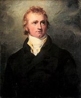
Alexander MacKenzie
Encyclopedia
Sir Alexander Mackenzie (or MacKenzie, , 1764 – March 12, 1820) was a Scottish
explorer. He is known for his crossing of Canada to reach the Pacific Ocean
in 1793.
in the Outer Hebrides
, Scotland
. Some sources report Mackenzie's birth as being in the year 1764, others 1762; the exact date is unknown. In 1774, his family moved to New York
and then to Montreal
in 1776 during the American War of Independence. By 1779 he was working for Finley and Gregory, a fur trading Company later administered by Normand Macleod
. In 1787 this company merged with the rival North West Company
.
Mackenzie travelled to Lake Athabasca
where, in 1788, he was one of the founders of Fort Chipewyan. He had been sent to replace Peter Pond
, a partner in the North West Company
. From Pond, he learned that the First Nations
people understood that the local rivers flowed to the northwest. Acting on this information, he set out by canoe on the river known to the local Dene First Nations people as the Dehcho, (Mackenzie River) on July 10, 1789 following it to its mouth in the hope of finding the Northwest Passage
to the Pacific Ocean
. As he ended up reaching the Arctic Ocean
on 14 July, it is conjectured that he named the river "Disappointment River" as it did not lead to Cook Inlet
in Alaska
as he had expected. The river was later renamed the Mackenzie River
in his honor.
 In 1791, Mackenzie returned to Great Britain to study the new advance in the measurement of longitude
. Upon his return in 1792, he set out once again to find a route to the Pacific. Accompanied by native guides, French voyageurs
and a dog called "Our Dog", Mackenzie left Fort Fork
following the route of the Peace River
. He crossed the continental divide
and found the upper reaches of the Fraser River
but was warned by the local natives that the Fraser Canyon
to the south was unnavigable and populated by belligerent tribes. He was instead directed to follow a grease trail
by ascending the West Road River
, crossing over the Coast Mountains
and descending the Bella Coola River
to the sea. He followed this advice and reached the Pacific coast on July 20, 1793 at Bella Coola, British Columbia
, on North Bentinck Arm
, an inlet
of the Pacific Ocean. Thus, he completed the first recorded transcontinental crossing of North America
north of Mexico
. He had unknowingly missed meeting George Vancouver
at Bella Coola by 48 days. He had wanted to continue westward out of a desire to encounter the open ocean but was turned back by the hostility of the Heiltsuk nation. At his westernmost point on Dean Channel
, (on July 22, 1793), hemmed in by Heiltsuk war canoes, he inscribed "Alex MacKenzie / from Canada / by land / 22d July 1793" on a rock using a reddish paint made of vermilion and bear grease and turned around to return to "Canada". The rock, near the water's edge in Dean Channel
, still bears these words which were permanently inscribed later by surveyors. The site is now Sir Alexander Mackenzie Provincial Park
and is designated a National Historic Site of Canada.
from 1804 to 1808. In 1812, he married and returned to Scotland
. Mackenzie died in 1820 of Bright's disease
, at an age ranging from 53 to 56, (his exact date of birth unknown). He is buried in Avoch
, on the Black Isle
, Ross and Cromarty
.
Many others have set out to replicate his famous crossing of Canada by canoe.
Scottish people
The Scottish people , or Scots, are a nation and ethnic group native to Scotland. Historically they emerged from an amalgamation of the Picts and Gaels, incorporating neighbouring Britons to the south as well as invading Germanic peoples such as the Anglo-Saxons and the Norse.In modern use,...
explorer. He is known for his crossing of Canada to reach the Pacific Ocean
Pacific Ocean
The Pacific Ocean is the largest of the Earth's oceanic divisions. It extends from the Arctic in the north to the Southern Ocean in the south, bounded by Asia and Australia in the west, and the Americas in the east.At 165.2 million square kilometres in area, this largest division of the World...
in 1793.
Early life
Mackenzie was born in Stornoway on the isle of LewisLewis
Lewis is the northern part of Lewis and Harris, the largest island of the Western Isles or Outer Hebrides of Scotland. The total area of Lewis is ....
in the Outer Hebrides
Outer Hebrides
The Outer Hebrides also known as the Western Isles and the Long Island, is an island chain off the west coast of Scotland. The islands are geographically contiguous with Comhairle nan Eilean Siar, one of the 32 unitary council areas of Scotland...
, Scotland
Scotland
Scotland is a country that is part of the United Kingdom. Occupying the northern third of the island of Great Britain, it shares a border with England to the south and is bounded by the North Sea to the east, the Atlantic Ocean to the north and west, and the North Channel and Irish Sea to the...
. Some sources report Mackenzie's birth as being in the year 1764, others 1762; the exact date is unknown. In 1774, his family moved to New York
New York City
New York is the most populous city in the United States and the center of the New York Metropolitan Area, one of the most populous metropolitan areas in the world. New York exerts a significant impact upon global commerce, finance, media, art, fashion, research, technology, education, and...
and then to Montreal
Montreal
Montreal is a city in Canada. It is the largest city in the province of Quebec, the second-largest city in Canada and the seventh largest in North America...
in 1776 during the American War of Independence. By 1779 he was working for Finley and Gregory, a fur trading Company later administered by Normand Macleod
Normand Macleod
Normand MacLeod was a British army officer, merchant, and official of the British Indian Department.He was born on the Isle of Skye, in Scotland, about 1731. At age sixteen he joined the Forty Second Highlanders Regiment, and went with his unit to the Netherlands and what is now Belgium...
. In 1787 this company merged with the rival North West Company
North West Company
The North West Company was a fur trading business headquartered in Montreal from 1779 to 1821. It competed with increasing success against the Hudson's Bay Company in what was to become Western Canada...
.
1787 Mackenzie River expedition to the Arctic Ocean
On behalf of the North West CompanyNorth West Company
The North West Company was a fur trading business headquartered in Montreal from 1779 to 1821. It competed with increasing success against the Hudson's Bay Company in what was to become Western Canada...
Mackenzie travelled to Lake Athabasca
Lake Athabasca
Lake Athabasca is located in the northwest corner of Saskatchewan and the northeast corner of Alberta between 58° and 60° N.-History:The name in the Dene language originally referred only to the large delta formed by the confluence the Athabasca River at the southwest corner of the lake...
where, in 1788, he was one of the founders of Fort Chipewyan. He had been sent to replace Peter Pond
Peter Pond
Peter Pond was born in Milford, Connecticut. He was a soldier with a Connecticut regiment, a fur trader, a founding member of the North West Company, an explorer and a cartographer.-Biography:...
, a partner in the North West Company
North West Company
The North West Company was a fur trading business headquartered in Montreal from 1779 to 1821. It competed with increasing success against the Hudson's Bay Company in what was to become Western Canada...
. From Pond, he learned that the First Nations
First Nations
First Nations is a term that collectively refers to various Aboriginal peoples in Canada who are neither Inuit nor Métis. There are currently over 630 recognised First Nations governments or bands spread across Canada, roughly half of which are in the provinces of Ontario and British Columbia. The...
people understood that the local rivers flowed to the northwest. Acting on this information, he set out by canoe on the river known to the local Dene First Nations people as the Dehcho, (Mackenzie River) on July 10, 1789 following it to its mouth in the hope of finding the Northwest Passage
Northwest Passage
The Northwest Passage is a sea route through the Arctic Ocean, along the northern coast of North America via waterways amidst the Canadian Arctic Archipelago, connecting the Atlantic and Pacific Oceans...
to the Pacific Ocean
Pacific Ocean
The Pacific Ocean is the largest of the Earth's oceanic divisions. It extends from the Arctic in the north to the Southern Ocean in the south, bounded by Asia and Australia in the west, and the Americas in the east.At 165.2 million square kilometres in area, this largest division of the World...
. As he ended up reaching the Arctic Ocean
Arctic Ocean
The Arctic Ocean, located in the Northern Hemisphere and mostly in the Arctic north polar region, is the smallest and shallowest of the world's five major oceanic divisions...
on 14 July, it is conjectured that he named the river "Disappointment River" as it did not lead to Cook Inlet
Cook Inlet
Cook Inlet stretches from the Gulf of Alaska to Anchorage in south-central Alaska. Cook Inlet branches into the Knik Arm and Turnagain Arm at its northern end, almost surrounding Anchorage....
in Alaska
Alaska
Alaska is the largest state in the United States by area. It is situated in the northwest extremity of the North American continent, with Canada to the east, the Arctic Ocean to the north, and the Pacific Ocean to the west and south, with Russia further west across the Bering Strait...
as he had expected. The river was later renamed the Mackenzie River
Mackenzie River
The Mackenzie River is the largest river system in Canada. It flows through a vast, isolated region of forest and tundra entirely within the country's Northwest Territories, although its many tributaries reach into four other Canadian provinces and territories...
in his honor.
1792-1793 Peace River expedition to the Pacific Ocean
Longitude
Longitude is a geographic coordinate that specifies the east-west position of a point on the Earth's surface. It is an angular measurement, usually expressed in degrees, minutes and seconds, and denoted by the Greek letter lambda ....
. Upon his return in 1792, he set out once again to find a route to the Pacific. Accompanied by native guides, French voyageurs
Voyageurs
The Voyageurs were the persons who engaged in the transportation of furs by canoe during the fur trade era. Voyageur is a French word which literally translates to "traveler"...
and a dog called "Our Dog", Mackenzie left Fort Fork
Fort Fork
Fort Fork a North West Company trading post on the Peace River, established in 1792. In May 1793, Alexander Mackenzie wintered there. The fort was used until the NWC merged with the XY Company in 1805, after which it was replaced by Fort Dunvegan, further upstream.The fort was located southwest...
following the route of the Peace River
Peace River (Canada)
The Peace River is a river in Canada that originates in the Rocky Mountains of northern British Columbia and flows to the northeast through northern Alberta. The Peace River flows into the Slave River, a tributary of the Mackenzie River. The Mackenzie is the 12th longest river in the world,...
. He crossed the continental divide
Continental divide
A continental divide is a drainage divide on a continent such that the drainage basin on one side of the divide feeds into one ocean or sea, and the basin on the other side either feeds into a different ocean or sea, or else is endorheic, not connected to the open sea...
and found the upper reaches of the Fraser River
Fraser River
The Fraser River is the longest river within British Columbia, Canada, rising at Fraser Pass near Mount Robson in the Rocky Mountains and flowing for , into the Strait of Georgia at the city of Vancouver. It is the tenth longest river in Canada...
but was warned by the local natives that the Fraser Canyon
Fraser Canyon
The Fraser Canyon is an 84 km landform of the Fraser River where it descends rapidly through narrow rock gorges in the Coast Mountains en route from the Interior Plateau of British Columbia to the Fraser Valley...
to the south was unnavigable and populated by belligerent tribes. He was instead directed to follow a grease trail
Grease trail
A grease trail is an overland trade route, part of a network of trails connecting the Pacific coast with the Interior in the Pacific Northwest. Trails were developed for trade between indigenous people, particularly the trade in eulachon oil. The grease from these small fish could be traded for...
by ascending the West Road River
West Road River
The West Road River or Blackwater River is a major tributary of the Fraser River, flowing generally north-eastward from the northern slopes of the Ilgachuz Range and across the Fraser Plateau in the Chilcotin region of central British Columbia, Canada...
, crossing over the Coast Mountains
Coast Mountains
The Coast Mountains are a major mountain range, in the Pacific Coast Ranges, of western North America, extending from southwestern Yukon through the Alaska Panhandle and virtually all of the Coast of British Columbia. They are so-named because of their proximity to the sea coast, and are often...
and descending the Bella Coola River
Bella Coola River
The Bella Coola River is a major river on the Pacific slope of the Coast Mountains in southern British Columbia. The town of Bella Coola, which is the historic and ancient capital of the Nuxalk people, is at its mouth on North Bentinck Arm...
to the sea. He followed this advice and reached the Pacific coast on July 20, 1793 at Bella Coola, British Columbia
Bella Coola, British Columbia
Bella Coola is a community of approximately 600 at the western extremity of the Bella Coola Valley. Bella Coola usually refers to the entire valley, encompassing the settlements of Bella Coola proper , Lower Bella Coola, Hagensborg, Saloompt, Nusatsum, Firvale and Stuie...
, on North Bentinck Arm
North Bentinck Arm
North Bentinck Arm is short inlet about in length in the Central Coast region of British Columbia, Canada. It is a sidewater of Burke Channel and is linked via that waterway and Labouchere Channel to Dean Channel, which is one of the largest inlets of the BC Coast.A spot on North Bentinck Arm is...
, an inlet
Fjord
Geologically, a fjord is a long, narrow inlet with steep sides or cliffs, created in a valley carved by glacial activity.-Formation:A fjord is formed when a glacier cuts a U-shaped valley by abrasion of the surrounding bedrock. Glacial melting is accompanied by rebound of Earth's crust as the ice...
of the Pacific Ocean. Thus, he completed the first recorded transcontinental crossing of North America
North America
North America is a continent wholly within the Northern Hemisphere and almost wholly within the Western Hemisphere. It is also considered a northern subcontinent of the Americas...
north of Mexico
Mexico
The United Mexican States , commonly known as Mexico , is a federal constitutional republic in North America. It is bordered on the north by the United States; on the south and west by the Pacific Ocean; on the southeast by Guatemala, Belize, and the Caribbean Sea; and on the east by the Gulf of...
. He had unknowingly missed meeting George Vancouver
George Vancouver
Captain George Vancouver RN was an English officer of the British Royal Navy, best known for his 1791-95 expedition, which explored and charted North America's northwestern Pacific Coast regions, including the coasts of contemporary Alaska, British Columbia, Washington and Oregon...
at Bella Coola by 48 days. He had wanted to continue westward out of a desire to encounter the open ocean but was turned back by the hostility of the Heiltsuk nation. At his westernmost point on Dean Channel
Dean Channel
Dean Channel is the upper end of one of the longest inlets of the British Columbia Coast, from its head at the mouth of the Kimsquit River. The Dean River, one of the main rivers of the Coast Mountains, enters Dean Channel about below the head of the inlet, at the community of...
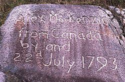
, (on July 22, 1793), hemmed in by Heiltsuk war canoes, he inscribed "Alex MacKenzie / from Canada / by land / 22d July 1793" on a rock using a reddish paint made of vermilion and bear grease and turned around to return to "Canada". The rock, near the water's edge in Dean Channel
Dean Channel
Dean Channel is the upper end of one of the longest inlets of the British Columbia Coast, from its head at the mouth of the Kimsquit River. The Dean River, one of the main rivers of the Coast Mountains, enters Dean Channel about below the head of the inlet, at the community of...
, still bears these words which were permanently inscribed later by surveyors. The site is now Sir Alexander Mackenzie Provincial Park
Sir Alexander Mackenzie Provincial Park
Sir Alexander Mackenzie Provincial Park is a provincial park in British Columbia, Canada. Located at the mouth of Elcho Harbour on Dean Channel, it enshrines the farthest point west reached by Alexander Mackenzie and the rock he marked to commemorate his journey.-External links:*...
and is designated a National Historic Site of Canada.
Later life
In 1801 the journals of his exploratory journeys were published. He was knighted for his efforts in the following year and served in the Legislature of Lower CanadaLegislative Assembly of Lower Canada
The Legislative Assembly of Lower Canada was the lower house of the bicameral structure of provincial government in Lower Canada until 1838. The legislative assembly was created by the Constitutional Act of 1791...
from 1804 to 1808. In 1812, he married and returned to Scotland
Scotland
Scotland is a country that is part of the United Kingdom. Occupying the northern third of the island of Great Britain, it shares a border with England to the south and is bounded by the North Sea to the east, the Atlantic Ocean to the north and west, and the North Channel and Irish Sea to the...
. Mackenzie died in 1820 of Bright's disease
Bright's disease
Bright's disease is a historical classification of kidney diseases that would be described in modern medicine as acute or chronic nephritis. The term is no longer used, as diseases are now classified according to their more fully understood causes....
, at an age ranging from 53 to 56, (his exact date of birth unknown). He is buried in Avoch
Avoch
Avoch is a harbour-village located on the south-east coast of the Black Isle, on the Moray Firth.Ormond Castle or Avoch Castle was a stronghold built on the site and served as a royal castle to William the Lion; passed on to the Morays of Petty then Archibald the Grim, Lord of Galloway, upon his...
, on the Black Isle
Black Isle
The Black Isle is an eastern area of the Highland local government council area of Scotland, within the county of Ross and Cromarty. The name nearly always includes the article "the"....
, Ross and Cromarty
Ross and Cromarty
Ross and Cromarty is a variously defined area in the Highlands and Islands of Scotland. There is a registration county and a lieutenancy area in current use...
.
Legacy
The Alexander Mackenzie rose, (explorer series) developed by Agriculture and Agri-Food Canada, was named in his honor.Many others have set out to replicate his famous crossing of Canada by canoe.