

Alba Patera
Encyclopedia
Alba Mons is an immense, low-lying volcano
located in the northern Tharsis
region of the planet Mars
. It is the largest volcano on Mars in terms of area, with volcanic flow fields that extend for at least 1350 km (839 mi) from its summit. Although the volcano has a span comparable to that of the United States
, it reaches an elevation of only 6.8 km (4.2 mi) at its highest point. This is about one-third the height of Olympus Mons
, the tallest volcano on the planet. The flanks of Alba Mons have very gentle slopes. The average slope along the volcano's northern (and steepest) flank is 0.5°, which is over five times lower than the slopes on the other large Tharsis volcanoes
. In broad profile, Alba Mons resembles a vast but barely raised welt on the planet's surface. It is a unique volcanic structure with no counterpart on Earth or elsewhere on Mars.
In addition to its great size and low relief
, Alba Mons has a number of other distinguishing features. The central portion of the volcano is surrounded by an incomplete ring of faults (graben
) and fractures, called Alba Fossae
on the volcano's western flank and Tantalus Fossae
on the eastern flank. The volcano also has very long, well preserved lava
flows that form a radiating pattern from the volcano's central region. The enormous lengths of some individual flows (>300 km) implies that the lavas were very fluid (low viscosity
) and of high volume. Many of the flows have distinctive morphologies, consisting of long, sinuous
ridges with discontinuous central lava channels. The low areas between the ridges (particularly along the volcano's northern flank) show a branching pattern of shallow gullies and channels (valley networks
) that likely formed by water runoff.
Alba Mons has some of the oldest, extensively exposed volcanic deposits in the Tharsis
region. Geologic evidence indicates that significant volcanic activity ended much earlier at Alba Mons than at Olympus Mons
and the Tharsis Montes
volcanoes. Volcanic deposits from Alba Mons range in age from Hesperian to early Amazonian (approximately 3600 to 3200 million years old).
(pl. paterae) is Latin
for a shallow drinking bowl or saucer. The term was applied to certain ill-defined, scalloped-edged craters that appeared in early spacecraft images to be volcanic (or non-impact
) in origin. In September 2007, the International Astronomical Union
(IAU) renamed the volcano Alba Mons (Alba Mountain), reserving the term Alba Patera for the volcano's two central depressions (caldera
s). Nevertheless, the entire volcano is still commonly called Alba Patera in the planetary science literature.
 The term Alba is from the Latin
word for white and refers to the clouds frequently seen over the region from Earth-based telescopes. The volcano was discovered by the Mariner 9
spacecraft in 1972 and was initially known as the Alba volcanic feature or the Arcadia Ring (in reference to the partial ring of fractures around the volcano). The IAU named the volcano Alba Patera in 1973. The volcano is often simply called Alba when the context is understood.
(MC-3). Much of the volcano's western flank is located in the adjacent Diacria quadrangle
(MC-2). Flows from the volcano can be found as far north as 61°N and as far south as 26°N (in the northern Tharsis quadrangle
). If one takes the outer margin of the flows as the volcano's base, then Alba Mons has north–south dimensions of about 2000 km and a maximum width of 3000 km. It covers an area of at least 5.7 million km2 and has a volume of about 2.5 million km3. The volcano dominates the northern portion of the Tharsis bulge and is so large and geologically distinct that it can almost be treated as an entire volcanic province unto itself.
Although Alba Mons reaches a maximum elevation of 6.8 km above Mars’ datum, the elevation difference between its summit and surrounding terrain (relief) is much greater on the north side of the volcano (about 7.1 km) compared to the south side (about 2.6 km). The reason for this asymmetry is that Alba straddles the dichotomy
boundary between the cratered uplands in the south and the lowlands to the north. The plains underlying the volcano slope northward toward the Vastitas Borealis
, which has an average surface elevation of 4.5 km below datum (-4,500 m). The southern part of Alba Mons is built on a broad, north-south topographic ridge that corresponds to the fractured, Noachian-aged terrain of Ceraunius Fossae
(pictured left).
spacecraft took over 670 million precise elevation measurements across the planet. Using MOLA data, planetary scientists are able to study subtle details of the volcano's shape and topography
that were invisible in images from earlier spacecraft such as Viking
.
The volcano consists of two, roughly concentric components: 1) an oval-shaped central body with approximate dimensions of 1500 by 1000 km across surrounded by 2) a vast, nearly level apron of lava flows that extends an additional 1000 km or so outward. The central body is the main topographic edifice of the volcano, marked by pronounced break in slope at the inner boundary of the apron. Extending east and west from the central edifice are two broad fan-shaped lobes (or shoulders), which give the volcano its elongation in the east-west direction. The central edifice has the steepest slopes on the volcano, although they are still only 1°. The crest and upper flanks of the edifice are cut by a partial ring of graben
that are part of the Alba and Tantalus Fossae
fracture system. Inside the ring of graben is an annulus
of very low and in places reversed slopes that forms a plateau on top of which lies a central dome 350 km across capped by a nested caldera
complex. Thus, the central edifice of Alba Mons resembles a partially collapsed shield volcano
with a smaller, summit dome sitting on top (pictured right). The summit dome has a distinct tilt to the east.
The caldera complex consists of a large caldera about 170 by 100 km across at the center of the summit dome. A smaller, kidney-shaped caldera (about 65 by 45 km) lies in the southern half of the larger one. Both calderas are relatively shallow, reaching a maximum depth of only 1.2 km.
The larger caldera is bounded at the westernmost end by a steep, semicircular wall 500 m tall. This wall disappears at the northern and southern sides of the caldera, where it is buried by volcanic flows originating from the younger, smaller caldera. The smaller caldera is outlined everywhere by a steep wall that varies in height over a range of a few hundred meters. The walls of both calderas are scalloped, suggesting multiple episodes of subsidence
and/or mass wasting
. Two small shields or domes, several hundred meters high, occur within and adjacent to the large caldera. The shield within the large caldera is about 50 km across. It is capped by a peculiar concentric circular feature 10 km in diameter (pictured left).
Calderas form by collapse following withdrawal and depletion of a magma chamber after an eruption. Caldera dimensions allow scientists to infer the geometry and depth of the magma chamber beneath the summit of the volcano. The shallowness of Alba’s calderas compared to those seen on Olympus Mons
and most of the other Tharsis
volcanoes implies that Alba’s magma reservoir was wider and shallower than that of its neighbors.
Heavy dust cover is also indicated by the high albedo
(reflectivity) and low thermal inertia of the region. Martian dust is visually bright (albedo > 0.27) and has a low thermal inertia because of its small grain size (< 40 μm). (See the Martian surface
.) However, the thermal inertia is high and albedo lower on the northern flanks of the volcano and in the apron area farther to the north. This suggests that the northern portions of Alba’s surface may contain a higher abundance of duricrust
s, sand, and rocks compared to the rest of the volcano.
High thermal inertia can also indicate the presence of exposed water ice. Theoretical models of water-equivalent hydrogen (WEH) from epithermal neutrons detected by the Mars Odyssey Neutron Spectrometer (MONS) instrument suggest that the regolith
just below the surface on Alba's northern flank may contain 7.6% WEH by mass. This concentration could indicate water present as remnant ice or in hydrated minerals. Alba Mons is one of several areas on the planet that may contain thick deposits of near-surface ice preserved from an earlier epoch (1 to 10 million years ago), when Mars’ axial tilt
(obliquity) was higher and mountain glaciers existed at mid-latitudes and tropics. Water ice is unstable at these locations under present conditions and will tend to sublimate
into the atmosphere. Theoretical calculations indicate that remnant ice can be preserved below depths of 1 m if it is blanketed by a high-albedo and low-thermal-inertia material, such as dust.
The mineral composition of rocks making up Alba Mons is difficult to determine from orbital reflectance spectrometry because of the predominance of surface dust throughout the region. However, global-scale surface composition can be inferred from the Mars Odyssey gamma-ray spectrometer (GRS). This instrument has allowed scientists to determine the distribution of hydrogen
(H), silicon
(Si), iron
(Fe), chlorine
(Cl), thorium
(Th) and potassium
(K) in the shallow subsurface. Multivariate analysis
of GRS data indicates that Alba Mons and the rest of the Tharsis
region belongs to a chemically distinct province characterized by relatively low Si (19 wt%), Th (0.58 pppm), and K (0.29 wt%) content, but with Cl abundance (0.56 wt%) higher than Mars' surface average. Low silicon content is indicative of mafic
and ultramafic igneous rocks, such as basalt
and dunite
.
Alba Mons is an unlikely target for unmanned landers in the near future. The thick mantle of dust obscures the underlying bedrock, probably making in situ rock samples hard to come by and thus reducing the site's scientific value. The dust layer would also likely cause severe maneuvering problems for rovers. Ironically, the summit region was originally considered a prime backup landing site for the Viking 2
lander because the area appeared so smooth in Mariner 9
images taken in the early 1970s.
Sheet flows (also called tabular flows) form multiple, overlapping lobes with steep margins. The flows typically lack central channels. They are flat-topped and generally about 5 km wide on the upper flanks of the volcano but become much wider and lobate toward their downstream (distal) ends. Most appear to originate near the Alba and Tantalus Fossae fracture ring, but the actual vents for the sheet flows are not visible and may have been buried by their own products. Flow thicknesses have been measured for a number of sheet flows based on MOLA data. The flows range from 20 to 130 m thick and are generally thickest at their distal margins.
The second major type of lava flows on the flanks of Alba Mons are called tube- and channel-fed flows, or crested flows. They form long, sinuous ridges that radiate outward from the central region of the volcano. They are typically 5-10 km wide. An individual ridge may have a discontinuous channel or line of pits that run along its crest. Tube- and channel-fed flows are particularly prominent on the western flank of the volcano where individual ridges can be traced for several hundred kilometers. The origin of the ridges is uncertain. They may form by successive buildup of solidified lava at the mouth of a channel or tube, with each pulse of flowing lava adding to the length of the ridge.
In addition to the two main types of flows, numerous undifferentiated flows are present around Alba Mons that are either too degraded to characterize or have hybrid characteristics. Flat-topped ridges with indistinct margins and rugged surfaces, interpreted as lava flows, are common along Alba’s lower flanks and become less sharp in appearance with increasing distance from the edifice. In high resolution images, many of the flows on the volcano’s upper flanks originally characterized as sheet flows have central channels with levee-like ridges.
The morphology of lava flows can indicate properties of the lava when molten, such as its rheology
and flow volume. Together, these properties can provide clues to the lava’s composition and eruption rates. For example, lava tubes on Earth only form in lavas of basaltic
composition. Silica-rich lavas such as andesite
are too viscous for tubes to form. Early quantitative analysis of Alba's lava flows indicated that the lavas had low yield strength and viscosity
and were erupted at very high rates. Alba's unusually low profile suggested to some that extremely fluid lavas were involved in the volcano's construction, perhaps komatiite
s, which are primitive ultramafic lavas that form at very high temperatures. However, more recent work on the tube- and channel-fed flows indicates lava viscosities within the range of typical basalts (between 100 and 1 million Pa s-1). Calculated flow rates are also lower than originally thought, ranging from 10 to 1.3 million m3 per second. The lower range of eruption rates for Alba Mons is within the
range of the highest terrestrial volcanic flows, such as the 1984 Mauna Loa
, North Queensland
(McBride Province)
, and the Columbia River
basalts. The highest range is several orders of magnitude higher than the effusive rates for any terrestrial volcano.
Since the late 1980s, some researchers have suspected that Alba Mons eruptions included a significant amount of pyroclastics (and therefore explosive activity) during early phases of its development. The evidence was based on the presence of numerous valley networks on the volcano's northern flanks that appeared to be carved by running water (see below). This evidence combined with thermal inertia data, which indicated a surface dominated by fine-grained materials, suggested an easily erodible material, such as volcanic ash, was present. The volcano's extremely low profile is also more easily explained if the edifice were built largely from pyroclastic flow deposits (ignimbrite
s).
More recent data from Mars Global Surveyor
and the Mars Odyssey spacecraft have shown no specific evidence that explosive eruptions ever occurred at Alba Mons. An alternative explanation for the valley networks on the north side of the volcano is that they were produced through sapping
or melting of ice-rich dust deposited during a relatively recent, Amazonian-aged glacial epoch.
In summary, current geologic analysis of Alba Mons suggests that the volcano was built by lavas with rheological properties similar to basalt
s. If early explosive activity happened at Alba Mons, the evidence (in the form of extensive ash deposits) is largely buried by younger basaltic lavas.

. They form when the stresses exceed the yield strength of rock, resulting in the deformation of surface materials. Typically, this deformation is manifested as slip on faults that are recognizable in images from orbit.
Alba’s tectonic features are almost entirely extensional, consisting of normal faults, graben
and tension cracks. The most common extensional features on Alba Mons (and Mars in general) are simple graben
. Graben are long, narrow troughs bound by two inward-facing normal faults that enclose a downfaulted block of crust (pictured right). Alba has perhaps the clearest display of simple graben on the entire planet. Alba’s graben are up to 1000 km long, and have a width on the order of 2–10 km, with depths of 100–350 m.
Tension cracks (or joints) are extensional features produced when the crust is wrenched apart with no significant slippage between the separated rock masses. In theory they should appear as deep fissures with sharp V-shaped profiles, but in practice they are often difficult to distinguish from graben because their interiors rapidly fill with talus
from the surrounding walls to produce relatively flat, graben-like floors. Pit crater chain
s (catenae), common within many graben on Alba’s flanks, may be the surface manifestation of deep tension cracks into which surface material has drained.
The graben and fractures around Alba Mons (hereafter simply called faults unless otherwise indicated) occur in swarms that go by different names depending on their location with respect to Alba’s center. South of the volcano is a broad region of intensely fractured terrain called Ceraunius Fossae
, which consists of roughly parallel arrays of narrow, north-south oriented faults. These faults diverge around the flanks of the volcano, forming an incomplete ring about 500 km in diameter. The set of faults on Alba's western flank is called Alba Fossae and the one on the eastern flank Tantalus Fossae
. North of the volcano, the faults splay outward in a northeasterly directions for distances of many hundreds of kilometers. The pattern of faults curving around Alba's flanks has been likened in appearance to the grain of a piece of wood running past a knot. The entire Ceraunius-Alba-Tantalus fault system is at least 3000 km long and 900–1000 km wide
Several causes for the faults have been suggested, including regional stresses created by the Tharsis bulge, volcanic dikes, and crustal loading by Alba Mons itself. The faults of Ceraunius and Tantalus Fossae are roughly radial to the center of Tharsis
and are likely a crustal response to the sagging weight of the Tharsis bulge. The faults ringing Alba's summit region may be due to a combination of loading from the Alba edifice and magma uplift or underplating from the underlying mantle. Some of the fractures are likely the surface expression of gigantic dike swarm
s radial to Tharsis. An image from High Resolution Imaging Science Experiment (HiRISE
) on the Mars Reconnaissance Orbiter
(MRO) shows a line of rimless pit craters in Cyane Fossae
on the Alba's western flank (pictured right). The pits likely formed by the collapse of surface materials into open fractures created as magma intruded the subsurface rock to form dikes
.
that superficially resemble drainage features produced on Earth by rainfall. Alba's valley networks were identified in Mariner 9
and Viking
images in the 1970s, and their origin has long been a topic of Mars research. Valley networks are most common in the ancient Noachian-aged southern highlands of Mars, but also occur on the flanks of some of the large volcanoes. The valley networks on Alba Mons are Amazonian in age and thus significantly younger than the majority of those in the southern highlands. This fact presents a problem for researchers who propose that valley networks were carved by rainfall runoff during an early, warm and wet period of Martian history. If the climate conditions changed billions of years ago into today's cold and dry Mars (where rainfall is impossible), how does one explain the younger valleys on Alba Mons? Did Alba's valley networks form differently than those in the highlands, and if so, how? Why do the valleys on Alba Mons occur mainly on the northern flanks of the volcano? These questions are still being debated.
In Viking
images, the resemblance of Alba's valley networks to terrestrial pluvial
(rainfall) valleys is quite striking. The valley networks show a fine-textured, parallel to dendritic pattern
with well-integrated tributary valleys and drainage densities
comparable to those on Earth's Hawaiian
volcanoes. However, stereoscopic images from the High Resolution Stereo Camera (HRSC) on the European Mars Express
orbiter show that the valleys are relatively shallow (30 m or less) and more closely resemble rill
s or gullies
from intermittent runoff erosion than valleys formed from sustained erosion. It seems likely that the valleys on Alba Mons formed as a result of transient erosional processes, possibly related to snow melting during volcanic activity or periods of climate change. (See Surface characteristics, above.) Whether the eroded material is a ice-rich dust or friable
volcanic ash is still uncertain.
and basic principles of stratigraphy
, such as superposition
and cross-cutting relationships, geologists have been able to reconstruct much of Alba’s geologic and tectonic history. Most of the constructional volcanic activity at Alba is believed to have occurred within a relatively brief time interval (about 400 million years) of Mars history, spanning mostly the late Hesperian to very early Amazonian epochs. Faulting and graben formation in the region occurred in two early stages: one preceding and the other contemporaneous with the volcano’s formation. Two late stages of graben formation occurred after volcanic activity had largely ended.
Based on Viking Orbiter images, the volcanic materials related to the formation and evolution of the volcano have been grouped into the Alba Patera Formation, which consists of lower, middle, and upper members. Members low in the stratigraphic sequence are older than those lying above, in accordance with Steno's
law of superposition
.
The oldest unit (lower member) corresponds to the broad lava apron surrounding the Alba Mons edifice. This unit is characterized by sets of low, flat-topped ridges that form a radial pattern extending for hundreds of kilometers to the west, north, and northeast of the main edifice. The ridges are interpreted to be lava flows, although the flow margins are now degraded and difficult to delineate. Broad lava flows with flat-topped ridges are characteristic features of lava flood
provinces on Earth (e.g., Columbia River basalt
) that were formed at high eruption rates. Thus, the earliest phase of volcanic activity at Alba Mons probably involved massive effusive eruptions of low viscosity lavas that formed the volcano's broad, flat apron. Lava flows of the apron unit straddle the early Hesperian-late Hesperian boundary, having erupted approximately 3700 to 3500 million years ago.
The middle unit, which is early Amazonian in age, makes up the flanks of the main Alba edifice and records a time of more focused effusive activity consisting of long tube- and channel-fed flows. Volcanic spreading occurred in a northward direction forming the two flanking lobes. (See Olympus Mons
and Tharsis
for a discussion of volcanic spreading on Mars.) Faulting and graben formation at Alba and Tantalus Fossae occurred penecontemporaneous with the lava flows. Any early explosive activity on the volcano may have occurred during the culmination of this middle phase of activity, which ended about 3400 million years ago.
The youngest unit, also early Amazonian, covers the summit plateau, dome, and caldera complex. This period of activity is characterized by relatively short-length sheet flows and construction of the summit dome and the large caldera. This phase ended with an eastward tilting of the summit dome, which may have initiated additional graben formation in Alba Fossae. The last volcanic features to form were the small shield and caldera at the summit. Much later, between about 1,000 and 500 million years ago, a final stage of faulting occurred that may have been related to dike emplacement and the formation of pit crater chains.
, others as a lowland patera (in contrast to highland paterae, which are low-lying ancient volcanoes with furrowed ash deposits located in the southern Martian highlands), and still others consider it a one-of-a-kind volcanic structure unique to Mars. Some researchers have compared Alba Mons to coronae
structures on the planet Venus
. Alba Mons shares some characteristics with the Syrtis Major volcanic structure. (See Volcanism on Mars
.) Both volcanoes are Hesperian in age, cover large areas, have very low relief, and large shallow calderas. Also like Alba, Syrtis Major displays ridged tube- and channel-fed lava flows. Because Alba Mons lies antipodal
to the Hellas impact basin, a few researchers have conjectured that the volcano’s formation may have been related to crustal weakening from the Hellas impact, which produced strong seismic wave
s that focused on the opposite side of the planet.
Volcano
2. Bedrock3. Conduit 4. Base5. Sill6. Dike7. Layers of ash emitted by the volcano8. Flank| 9. Layers of lava emitted by the volcano10. Throat11. Parasitic cone12. Lava flow13. Vent14. Crater15...
located in the northern Tharsis
Tharsis
The Tharsis region on Mars is a vast volcanic plateau centered near the equator in Mars’ western hemisphere. The region is home to the largest volcanoes in the Solar System, including the three enormous shield volcanoes Arsia Mons, Pavonis Mons, and Ascraeus Mons, which are collectively known as...
region of the planet Mars
Mars
Mars is the fourth planet from the Sun in the Solar System. The planet is named after the Roman god of war, Mars. It is often described as the "Red Planet", as the iron oxide prevalent on its surface gives it a reddish appearance...
. It is the largest volcano on Mars in terms of area, with volcanic flow fields that extend for at least 1350 km (839 mi) from its summit. Although the volcano has a span comparable to that of the United States
United States
The United States of America is a federal constitutional republic comprising fifty states and a federal district...
, it reaches an elevation of only 6.8 km (4.2 mi) at its highest point. This is about one-third the height of Olympus Mons
Olympus Mons
Olympus Mons is a large volcanic mountain on the planet Mars. At a height of almost , it is one of the tallest mountains in the Solar System, three times as tall as Mount Everest and more than twice the height of Mauna Kea the tallest mountain on Earth. Olympus Mons is the youngest of the large...
, the tallest volcano on the planet. The flanks of Alba Mons have very gentle slopes. The average slope along the volcano's northern (and steepest) flank is 0.5°, which is over five times lower than the slopes on the other large Tharsis volcanoes
Tharsis Montes
The Tharsis Montes are three large shield volcanoes in the Tharsis region of the planet Mars. From north to south, the volcanoes are Ascraeus Mons, Pavonis Mons and Arsia Mons. Mons is the Latin word for mountain...
. In broad profile, Alba Mons resembles a vast but barely raised welt on the planet's surface. It is a unique volcanic structure with no counterpart on Earth or elsewhere on Mars.
In addition to its great size and low relief
Terrain
Terrain, or land relief, is the vertical and horizontal dimension of land surface. When relief is described underwater, the term bathymetry is used...
, Alba Mons has a number of other distinguishing features. The central portion of the volcano is surrounded by an incomplete ring of faults (graben
Graben
In geology, a graben is a depressed block of land bordered by parallel faults. Graben is German for ditch. Graben is used for both the singular and plural....
) and fractures, called Alba Fossae
Fossa (geology)
Fossa is a term used in planetary geology to describe a long, narrow depression on the surface of an extraterrestrial body, such as a planet or moon...
on the volcano's western flank and Tantalus Fossae
Tantalus Fossae
Tantalus Fossae is a group of troughs in the Arcadia quadrangle of Mars, located at 50.9° north latitude and 97.5° west longitude. They are about 2,400 km long and was named after an albedo feature at 35N, 110W. Troughs, like this one are called Fossae on Mars...
on the eastern flank. The volcano also has very long, well preserved lava
Lava
Lava refers both to molten rock expelled by a volcano during an eruption and the resulting rock after solidification and cooling. This molten rock is formed in the interior of some planets, including Earth, and some of their satellites. When first erupted from a volcanic vent, lava is a liquid at...
flows that form a radiating pattern from the volcano's central region. The enormous lengths of some individual flows (>300 km) implies that the lavas were very fluid (low viscosity
Viscosity
Viscosity is a measure of the resistance of a fluid which is being deformed by either shear or tensile stress. In everyday terms , viscosity is "thickness" or "internal friction". Thus, water is "thin", having a lower viscosity, while honey is "thick", having a higher viscosity...
) and of high volume. Many of the flows have distinctive morphologies, consisting of long, sinuous
Sinuous
Sinuous is a fictional snake from the third season of the animated children's television series The Animals of Farthing Wood based upon the books of the same name by author Colin Dann....
ridges with discontinuous central lava channels. The low areas between the ridges (particularly along the volcano's northern flank) show a branching pattern of shallow gullies and channels (valley networks
Valley networks (Mars)
Valley networks are branching networks of valleys on Mars that superficially resemble terrestrial river drainage basins. They are found mainly incised into the terrain of the martian southern highlands, and are typically - though not always - of Noachian age...
) that likely formed by water runoff.
Alba Mons has some of the oldest, extensively exposed volcanic deposits in the Tharsis
Tharsis
The Tharsis region on Mars is a vast volcanic plateau centered near the equator in Mars’ western hemisphere. The region is home to the largest volcanoes in the Solar System, including the three enormous shield volcanoes Arsia Mons, Pavonis Mons, and Ascraeus Mons, which are collectively known as...
region. Geologic evidence indicates that significant volcanic activity ended much earlier at Alba Mons than at Olympus Mons
Olympus Mons
Olympus Mons is a large volcanic mountain on the planet Mars. At a height of almost , it is one of the tallest mountains in the Solar System, three times as tall as Mount Everest and more than twice the height of Mauna Kea the tallest mountain on Earth. Olympus Mons is the youngest of the large...
and the Tharsis Montes
Tharsis Montes
The Tharsis Montes are three large shield volcanoes in the Tharsis region of the planet Mars. From north to south, the volcanoes are Ascraeus Mons, Pavonis Mons and Arsia Mons. Mons is the Latin word for mountain...
volcanoes. Volcanic deposits from Alba Mons range in age from Hesperian to early Amazonian (approximately 3600 to 3200 million years old).
Name origin
For years the volcano's formal name was Alba Patera. PateraPatera
A patera was a broad, shallow dish used for drinking, primarily in a ritual context such as a libation. These paterae were often used in Rome....
(pl. paterae) is Latin
Latin
Latin is an Italic language originally spoken in Latium and Ancient Rome. It, along with most European languages, is a descendant of the ancient Proto-Indo-European language. Although it is considered a dead language, a number of scholars and members of the Christian clergy speak it fluently, and...
for a shallow drinking bowl or saucer. The term was applied to certain ill-defined, scalloped-edged craters that appeared in early spacecraft images to be volcanic (or non-impact
Impact crater
In the broadest sense, the term impact crater can be applied to any depression, natural or manmade, resulting from the high velocity impact of a projectile with a larger body...
) in origin. In September 2007, the International Astronomical Union
International Astronomical Union
The International Astronomical Union IAU is a collection of professional astronomers, at the Ph.D. level and beyond, active in professional research and education in astronomy...
(IAU) renamed the volcano Alba Mons (Alba Mountain), reserving the term Alba Patera for the volcano's two central depressions (caldera
Caldera
A caldera is a cauldron-like volcanic feature usually formed by the collapse of land following a volcanic eruption, such as the one at Yellowstone National Park in the US. They are sometimes confused with volcanic craters...
s). Nevertheless, the entire volcano is still commonly called Alba Patera in the planetary science literature.
Latin
Latin is an Italic language originally spoken in Latium and Ancient Rome. It, along with most European languages, is a descendant of the ancient Proto-Indo-European language. Although it is considered a dead language, a number of scholars and members of the Christian clergy speak it fluently, and...
word for white and refers to the clouds frequently seen over the region from Earth-based telescopes. The volcano was discovered by the Mariner 9
Mariner 9
Mariner 9 was a NASA space orbiter that helped in the exploration of Mars and was part of the Mariner program. Mariner 9 was launched toward Mars on May 30, 1971 from Cape Canaveral Air Force Station and reached the planet on November 13 of the same year, becoming the first spacecraft to orbit...
spacecraft in 1972 and was initially known as the Alba volcanic feature or the Arcadia Ring (in reference to the partial ring of fractures around the volcano). The IAU named the volcano Alba Patera in 1973. The volcano is often simply called Alba when the context is understood.
Location and size
Alba Mons is centered at lat. 40.47°N, Long. 250.4°E in the Arcadia quadrangleArcadia quadrangle
The Arcadia quadrangle is one of a series of 30 quadrangle maps of Mars used by the United States Geological Survey Astrogeology Research Program. The quadrangle is located in the north-central portion of Mars’ western hemisphere and covers 240° to 300° east longitude and 30° to 65° north latitude...
(MC-3). Much of the volcano's western flank is located in the adjacent Diacria quadrangle
Diacria quadrangle
The Diacria quadrangle is one of a series of 30 quadrangle maps of Mars used by the United States Geological Survey Astrogeology Research Program. The quadrangle is located in the northwestern portion of Mars’ western hemisphere and covers 180° to 240° east longitude and 30° to 65° north latitude...
(MC-2). Flows from the volcano can be found as far north as 61°N and as far south as 26°N (in the northern Tharsis quadrangle
Tharsis quadrangle
The Tharsis quadrangle is one of a series of 30 quadrangle maps of Mars used by the United States Geological Survey Astrogeology Research Program. The Tharsis quadrangle is also referred to as MC-9 ....
). If one takes the outer margin of the flows as the volcano's base, then Alba Mons has north–south dimensions of about 2000 km and a maximum width of 3000 km. It covers an area of at least 5.7 million km2 and has a volume of about 2.5 million km3. The volcano dominates the northern portion of the Tharsis bulge and is so large and geologically distinct that it can almost be treated as an entire volcanic province unto itself.
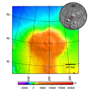
Although Alba Mons reaches a maximum elevation of 6.8 km above Mars’ datum, the elevation difference between its summit and surrounding terrain (relief) is much greater on the north side of the volcano (about 7.1 km) compared to the south side (about 2.6 km). The reason for this asymmetry is that Alba straddles the dichotomy
Martian dichotomy
The most conspicuous feature of Martian surface geology is a sharp contrast, known as the Martian dichotomy, between the rugged southern highlands and the relatively smooth northern basins. The two hemispheres differ in elevation by 1 to 3 km...
boundary between the cratered uplands in the south and the lowlands to the north. The plains underlying the volcano slope northward toward the Vastitas Borealis
Vastitas Borealis
Vastitas Borealis is the largest lowland region of Mars. It is in the northerly latitudes of the planet and encircles the northern polar region. Vastitas Borealis is often simply referred to as the Northern plains or Northern lowlands of Mars. The plains lie 4–5 km below the mean radius of...
, which has an average surface elevation of 4.5 km below datum (-4,500 m). The southern part of Alba Mons is built on a broad, north-south topographic ridge that corresponds to the fractured, Noachian-aged terrain of Ceraunius Fossae
Ceraunius Fossae
Ceraunius Fossae is an area of intensely fractured terrain in the northern Tharsis region of Mars. It lies directly south of the large volcano Alba Mons and consists of ancient highland crust that has been deformed by numerous parallel faults and tension cracks...
(pictured left).
Physical description
Alba's size and low profile makes it a difficult structure to study visually, as much of the volcano's relief is indiscernible in orbital photographs. However, between 1997 and 2001, the Mars Orbital Laser Altimeter (MOLA) instrument of the Mars Global SurveyorMars Global Surveyor
The Mars Global Surveyor was a US spacecraft developed by NASA's Jet Propulsion Laboratory and launched November 1996. It began the United States's return to Mars after a 10-year absence. It completed its primary mission in January 2001 and was in its third extended mission phase when, on 2...
spacecraft took over 670 million precise elevation measurements across the planet. Using MOLA data, planetary scientists are able to study subtle details of the volcano's shape and topography
Topography
Topography is the study of Earth's surface shape and features or those ofplanets, moons, and asteroids...
that were invisible in images from earlier spacecraft such as Viking
Viking program
The Viking program consisted of a pair of American space probes sent to Mars, Viking 1 and Viking 2. Each spacecraft was composed of two main parts, an orbiter designed to photograph the surface of Mars from orbit, and a lander designed to study the planet from the surface...
.
The volcano consists of two, roughly concentric components: 1) an oval-shaped central body with approximate dimensions of 1500 by 1000 km across surrounded by 2) a vast, nearly level apron of lava flows that extends an additional 1000 km or so outward. The central body is the main topographic edifice of the volcano, marked by pronounced break in slope at the inner boundary of the apron. Extending east and west from the central edifice are two broad fan-shaped lobes (or shoulders), which give the volcano its elongation in the east-west direction. The central edifice has the steepest slopes on the volcano, although they are still only 1°. The crest and upper flanks of the edifice are cut by a partial ring of graben
Graben
In geology, a graben is a depressed block of land bordered by parallel faults. Graben is German for ditch. Graben is used for both the singular and plural....
that are part of the Alba and Tantalus Fossae
Tantalus Fossae
Tantalus Fossae is a group of troughs in the Arcadia quadrangle of Mars, located at 50.9° north latitude and 97.5° west longitude. They are about 2,400 km long and was named after an albedo feature at 35N, 110W. Troughs, like this one are called Fossae on Mars...
fracture system. Inside the ring of graben is an annulus
Annulus (mathematics)
In mathematics, an annulus is a ring-shaped geometric figure, or more generally, a term used to name a ring-shaped object. Or, it is the area between two concentric circles...
of very low and in places reversed slopes that forms a plateau on top of which lies a central dome 350 km across capped by a nested caldera
Caldera
A caldera is a cauldron-like volcanic feature usually formed by the collapse of land following a volcanic eruption, such as the one at Yellowstone National Park in the US. They are sometimes confused with volcanic craters...
complex. Thus, the central edifice of Alba Mons resembles a partially collapsed shield volcano
Shield volcano
A shield volcano is a type of volcano usually built almost entirely of fluid lava flows. They are named for their large size and low profile, resembling a warrior's shield. This is caused by the highly fluid lava they erupt, which travels farther than lava erupted from more explosive volcanoes...
with a smaller, summit dome sitting on top (pictured right). The summit dome has a distinct tilt to the east.
The caldera complex consists of a large caldera about 170 by 100 km across at the center of the summit dome. A smaller, kidney-shaped caldera (about 65 by 45 km) lies in the southern half of the larger one. Both calderas are relatively shallow, reaching a maximum depth of only 1.2 km.
The larger caldera is bounded at the westernmost end by a steep, semicircular wall 500 m tall. This wall disappears at the northern and southern sides of the caldera, where it is buried by volcanic flows originating from the younger, smaller caldera. The smaller caldera is outlined everywhere by a steep wall that varies in height over a range of a few hundred meters. The walls of both calderas are scalloped, suggesting multiple episodes of subsidence
Subsidence
Subsidence is the motion of a surface as it shifts downward relative to a datum such as sea-level. The opposite of subsidence is uplift, which results in an increase in elevation...
and/or mass wasting
Mass wasting
Mass wasting, also known as slope movement or mass movement, is the geomorphic process by which soil, regolith, and rock move downslope under the force of gravity. Types of mass wasting include creep, slides, flows, topples, and falls, each with its own characteristic features, and taking place...
. Two small shields or domes, several hundred meters high, occur within and adjacent to the large caldera. The shield within the large caldera is about 50 km across. It is capped by a peculiar concentric circular feature 10 km in diameter (pictured left).
Calderas form by collapse following withdrawal and depletion of a magma chamber after an eruption. Caldera dimensions allow scientists to infer the geometry and depth of the magma chamber beneath the summit of the volcano. The shallowness of Alba’s calderas compared to those seen on Olympus Mons
Olympus Mons
Olympus Mons is a large volcanic mountain on the planet Mars. At a height of almost , it is one of the tallest mountains in the Solar System, three times as tall as Mount Everest and more than twice the height of Mauna Kea the tallest mountain on Earth. Olympus Mons is the youngest of the large...
and most of the other Tharsis
Tharsis
The Tharsis region on Mars is a vast volcanic plateau centered near the equator in Mars’ western hemisphere. The region is home to the largest volcanoes in the Solar System, including the three enormous shield volcanoes Arsia Mons, Pavonis Mons, and Ascraeus Mons, which are collectively known as...
volcanoes implies that Alba’s magma reservoir was wider and shallower than that of its neighbors.
Surface characteristics
Most of the central edifice of Alba Mons is mantled with a layer of dust approximately 2 meters thick. The dust layer is visible in high resolution images of the summit (pictured right). In places, the dust has been carved into streamlined shapes by the wind and is cut by small landslides. However, some isolated patches of dust appear smooth and undisturbed by the wind.Heavy dust cover is also indicated by the high albedo
Albedo
Albedo , or reflection coefficient, is the diffuse reflectivity or reflecting power of a surface. It is defined as the ratio of reflected radiation from the surface to incident radiation upon it...
(reflectivity) and low thermal inertia of the region. Martian dust is visually bright (albedo > 0.27) and has a low thermal inertia because of its small grain size (< 40 μm). (See the Martian surface
Martian Surface
The study of surface characteristics is a broad category of Mars science that examines the nature of the materials making up the Martian surface. The study evolved from telescopic and remote-sensing techniques developed by astronomers to study planetary surfaces...
.) However, the thermal inertia is high and albedo lower on the northern flanks of the volcano and in the apron area farther to the north. This suggests that the northern portions of Alba’s surface may contain a higher abundance of duricrust
Duricrust
Duricrust is a hard layer on or near the surface of soil. Duricrusts can range in thickness from a few millimeters or centimeters to several meters....
s, sand, and rocks compared to the rest of the volcano.
High thermal inertia can also indicate the presence of exposed water ice. Theoretical models of water-equivalent hydrogen (WEH) from epithermal neutrons detected by the Mars Odyssey Neutron Spectrometer (MONS) instrument suggest that the regolith
Regolith
Regolith is a layer of loose, heterogeneous material covering solid rock. It includes dust, soil, broken rock, and other related materials and is present on Earth, the Moon, some asteroids, and other terrestrial planets and moons.-Etymology:...
just below the surface on Alba's northern flank may contain 7.6% WEH by mass. This concentration could indicate water present as remnant ice or in hydrated minerals. Alba Mons is one of several areas on the planet that may contain thick deposits of near-surface ice preserved from an earlier epoch (1 to 10 million years ago), when Mars’ axial tilt
Axial tilt
In astronomy, axial tilt is the angle between an object's rotational axis, and a line perpendicular to its orbital plane...
(obliquity) was higher and mountain glaciers existed at mid-latitudes and tropics. Water ice is unstable at these locations under present conditions and will tend to sublimate
Sublimation
Sublimation may refer to:* Sublimation , the change from solid to gas without entering liquid phase* Sublimation , the transformation of emotions* Sublimation , a music album by Canvas Solaris-See also:...
into the atmosphere. Theoretical calculations indicate that remnant ice can be preserved below depths of 1 m if it is blanketed by a high-albedo and low-thermal-inertia material, such as dust.
The mineral composition of rocks making up Alba Mons is difficult to determine from orbital reflectance spectrometry because of the predominance of surface dust throughout the region. However, global-scale surface composition can be inferred from the Mars Odyssey gamma-ray spectrometer (GRS). This instrument has allowed scientists to determine the distribution of hydrogen
Hydrogen
Hydrogen is the chemical element with atomic number 1. It is represented by the symbol H. With an average atomic weight of , hydrogen is the lightest and most abundant chemical element, constituting roughly 75% of the Universe's chemical elemental mass. Stars in the main sequence are mainly...
(H), silicon
Silicon
Silicon is a chemical element with the symbol Si and atomic number 14. A tetravalent metalloid, it is less reactive than its chemical analog carbon, the nonmetal directly above it in the periodic table, but more reactive than germanium, the metalloid directly below it in the table...
(Si), iron
Iron
Iron is a chemical element with the symbol Fe and atomic number 26. It is a metal in the first transition series. It is the most common element forming the planet Earth as a whole, forming much of Earth's outer and inner core. It is the fourth most common element in the Earth's crust...
(Fe), chlorine
Chlorine
Chlorine is the chemical element with atomic number 17 and symbol Cl. It is the second lightest halogen, found in the periodic table in group 17. The element forms diatomic molecules under standard conditions, called dichlorine...
(Cl), thorium
Thorium
Thorium is a natural radioactive chemical element with the symbol Th and atomic number 90. It was discovered in 1828 and named after Thor, the Norse god of thunder....
(Th) and potassium
Potassium
Potassium is the chemical element with the symbol K and atomic number 19. Elemental potassium is a soft silvery-white alkali metal that oxidizes rapidly in air and is very reactive with water, generating sufficient heat to ignite the hydrogen emitted in the reaction.Potassium and sodium are...
(K) in the shallow subsurface. Multivariate analysis
Multivariate analysis
Multivariate analysis is based on the statistical principle of multivariate statistics, which involves observation and analysis of more than one statistical variable at a time...
of GRS data indicates that Alba Mons and the rest of the Tharsis
Tharsis
The Tharsis region on Mars is a vast volcanic plateau centered near the equator in Mars’ western hemisphere. The region is home to the largest volcanoes in the Solar System, including the three enormous shield volcanoes Arsia Mons, Pavonis Mons, and Ascraeus Mons, which are collectively known as...
region belongs to a chemically distinct province characterized by relatively low Si (19 wt%), Th (0.58 pppm), and K (0.29 wt%) content, but with Cl abundance (0.56 wt%) higher than Mars' surface average. Low silicon content is indicative of mafic
Mafic
Mafic is an adjective describing a silicate mineral or rock that is rich in magnesium and iron; the term is a portmanteau of the words "magnesium" and "ferric". Most mafic minerals are dark in color and the relative density is greater than 3. Common rock-forming mafic minerals include olivine,...
and ultramafic igneous rocks, such as basalt
Basalt
Basalt is a common extrusive volcanic rock. It is usually grey to black and fine-grained due to rapid cooling of lava at the surface of a planet. It may be porphyritic containing larger crystals in a fine matrix, or vesicular, or frothy scoria. Unweathered basalt is black or grey...
and dunite
Dunite
Dunite is an igneous, plutonic rock, of ultramafic composition, with coarse-grained or phaneritic texture. The mineral assemblage is greater than 90% olivine, with minor amounts of other minerals such as pyroxene, chromite and pyrope. Dunite is the olivine-rich end-member of the peridotite group...
.
Alba Mons is an unlikely target for unmanned landers in the near future. The thick mantle of dust obscures the underlying bedrock, probably making in situ rock samples hard to come by and thus reducing the site's scientific value. The dust layer would also likely cause severe maneuvering problems for rovers. Ironically, the summit region was originally considered a prime backup landing site for the Viking 2
Viking 2
The Viking 2 mission was part of the American Viking program to Mars, and consisted of an orbiter and a lander essentially identical to that of the Viking 1 mission. The Viking 2 lander operated on the surface for 1,281 Mars days and was turned off on 11 April 1980 when its batteries failed...
lander because the area appeared so smooth in Mariner 9
Mariner 9
Mariner 9 was a NASA space orbiter that helped in the exploration of Mars and was part of the Mariner program. Mariner 9 was launched toward Mars on May 30, 1971 from Cape Canaveral Air Force Station and reached the planet on November 13 of the same year, becoming the first spacecraft to orbit...
images taken in the early 1970s.
Geology
Much of the geologic work on Alba Mons has focused on the morphology of its lava flows and the geometry of the faults cutting its flanks. Surface features of the volcano, such as gullies and valley networks, have also been extensively studied. These efforts have the overall goal of deciphering the geologic history of the volcano and the volcano-tectonic processes involved in its formation. Such understanding can shed light on the nature and evolution of the Martian interior and the planet's climate history.Lava flows
Alba Mons is notable for the remarkable length, diversity, and crisp appearance of its lava flows. Many of the flows radiate from the summit, but others appear to originate from vents and fissures on the lower flanks of the volcano. Individual flows may exceed 500 km in length. Lava flows near the summit calderas appear to be significantly shorter and narrower than those on more distal parts of the volcano. The two most common types of volcanic flows on Alba Mons are sheet flows and tube-and-channel fed flows.Sheet flows (also called tabular flows) form multiple, overlapping lobes with steep margins. The flows typically lack central channels. They are flat-topped and generally about 5 km wide on the upper flanks of the volcano but become much wider and lobate toward their downstream (distal) ends. Most appear to originate near the Alba and Tantalus Fossae fracture ring, but the actual vents for the sheet flows are not visible and may have been buried by their own products. Flow thicknesses have been measured for a number of sheet flows based on MOLA data. The flows range from 20 to 130 m thick and are generally thickest at their distal margins.
The second major type of lava flows on the flanks of Alba Mons are called tube- and channel-fed flows, or crested flows. They form long, sinuous ridges that radiate outward from the central region of the volcano. They are typically 5-10 km wide. An individual ridge may have a discontinuous channel or line of pits that run along its crest. Tube- and channel-fed flows are particularly prominent on the western flank of the volcano where individual ridges can be traced for several hundred kilometers. The origin of the ridges is uncertain. They may form by successive buildup of solidified lava at the mouth of a channel or tube, with each pulse of flowing lava adding to the length of the ridge.
In addition to the two main types of flows, numerous undifferentiated flows are present around Alba Mons that are either too degraded to characterize or have hybrid characteristics. Flat-topped ridges with indistinct margins and rugged surfaces, interpreted as lava flows, are common along Alba’s lower flanks and become less sharp in appearance with increasing distance from the edifice. In high resolution images, many of the flows on the volcano’s upper flanks originally characterized as sheet flows have central channels with levee-like ridges.
The morphology of lava flows can indicate properties of the lava when molten, such as its rheology
Rheology
Rheology is the study of the flow of matter, primarily in the liquid state, but also as 'soft solids' or solids under conditions in which they respond with plastic flow rather than deforming elastically in response to an applied force....
and flow volume. Together, these properties can provide clues to the lava’s composition and eruption rates. For example, lava tubes on Earth only form in lavas of basaltic
Basalt
Basalt is a common extrusive volcanic rock. It is usually grey to black and fine-grained due to rapid cooling of lava at the surface of a planet. It may be porphyritic containing larger crystals in a fine matrix, or vesicular, or frothy scoria. Unweathered basalt is black or grey...
composition. Silica-rich lavas such as andesite
Andesite
Andesite is an extrusive igneous, volcanic rock, of intermediate composition, with aphanitic to porphyritic texture. In a general sense, it is the intermediate type between basalt and dacite. The mineral assemblage is typically dominated by plagioclase plus pyroxene and/or hornblende. Magnetite,...
are too viscous for tubes to form. Early quantitative analysis of Alba's lava flows indicated that the lavas had low yield strength and viscosity
Viscosity
Viscosity is a measure of the resistance of a fluid which is being deformed by either shear or tensile stress. In everyday terms , viscosity is "thickness" or "internal friction". Thus, water is "thin", having a lower viscosity, while honey is "thick", having a higher viscosity...
and were erupted at very high rates. Alba's unusually low profile suggested to some that extremely fluid lavas were involved in the volcano's construction, perhaps komatiite
Komatiite
Komatiite is a type of ultramafic mantle-derived volcanic rock. Komatiites have low silicon, potassium and aluminium, and high to extremely high magnesium content...
s, which are primitive ultramafic lavas that form at very high temperatures. However, more recent work on the tube- and channel-fed flows indicates lava viscosities within the range of typical basalts (between 100 and 1 million Pa s-1). Calculated flow rates are also lower than originally thought, ranging from 10 to 1.3 million m3 per second. The lower range of eruption rates for Alba Mons is within the
range of the highest terrestrial volcanic flows, such as the 1984 Mauna Loa
Mauna Loa
Mauna Loa is one of five volcanoes that form the Island of Hawaii in the U.S. state of Hawaii in the Pacific Ocean, and the largest on Earth in terms of volume and area covered. It is an active shield volcano, with a volume estimated at approximately , although its peak is about lower than that...
, North Queensland
North Queensland
North Queensland or the Northern Region is the northern part of the state of Queensland in Australia. Queensland is a massive state, larger than most countries, and the tropical northern part of it has been historically remote and undeveloped, resulting in a distinctive regional character and...
(McBride Province)
Undara Volcanic National Park
Undara Volcanic is a national park in North Queensland, Australia and is notable for its lava tubes and gem fossicking. Minerals found there include topaz, moonstone, peridot, aquamarine, garnet, quartz and gold...
, and the Columbia River
Columbia River Basalt Group
The Columbia River Basalt Group is a large igneous province that lies across parts of the Western United States. It is found in the U.S. states of Washington, Oregon, Idaho, Nevada, and California...
basalts. The highest range is several orders of magnitude higher than the effusive rates for any terrestrial volcano.
Since the late 1980s, some researchers have suspected that Alba Mons eruptions included a significant amount of pyroclastics (and therefore explosive activity) during early phases of its development. The evidence was based on the presence of numerous valley networks on the volcano's northern flanks that appeared to be carved by running water (see below). This evidence combined with thermal inertia data, which indicated a surface dominated by fine-grained materials, suggested an easily erodible material, such as volcanic ash, was present. The volcano's extremely low profile is also more easily explained if the edifice were built largely from pyroclastic flow deposits (ignimbrite
Ignimbrite
An ignimbrite is the deposit of a pyroclastic density current, or pyroclastic flow, a hot suspension of particles and gases that flows rapidly from a volcano, driven by a greater density than the surrounding atmosphere....
s).
More recent data from Mars Global Surveyor
Mars Global Surveyor
The Mars Global Surveyor was a US spacecraft developed by NASA's Jet Propulsion Laboratory and launched November 1996. It began the United States's return to Mars after a 10-year absence. It completed its primary mission in January 2001 and was in its third extended mission phase when, on 2...
and the Mars Odyssey spacecraft have shown no specific evidence that explosive eruptions ever occurred at Alba Mons. An alternative explanation for the valley networks on the north side of the volcano is that they were produced through sapping
Groundwater sapping
Groundwater sapping is the geomorphic process in which groundwater exits a bank or hillslope laterally as seeps and springs and erodes soil from the slope. This often causes the slope to be undermined and undergo mass wasting, hence the word sapping....
or melting of ice-rich dust deposited during a relatively recent, Amazonian-aged glacial epoch.
In summary, current geologic analysis of Alba Mons suggests that the volcano was built by lavas with rheological properties similar to basalt
Basalt
Basalt is a common extrusive volcanic rock. It is usually grey to black and fine-grained due to rapid cooling of lava at the surface of a planet. It may be porphyritic containing larger crystals in a fine matrix, or vesicular, or frothy scoria. Unweathered basalt is black or grey...
s. If early explosive activity happened at Alba Mons, the evidence (in the form of extensive ash deposits) is largely buried by younger basaltic lavas.
Tectonic Features
The immense system of fractures surrounding Alba Mons is perhaps the most striking feature of the volcano. The fractures are tectonic features indicating stresses in the planet's lithosphereLithosphere
The lithosphere is the rigid outermost shell of a rocky planet. On Earth, it comprises the crust and the portion of the upper mantle that behaves elastically on time scales of thousands of years or greater.- Earth's lithosphere :...
. They form when the stresses exceed the yield strength of rock, resulting in the deformation of surface materials. Typically, this deformation is manifested as slip on faults that are recognizable in images from orbit.
Alba’s tectonic features are almost entirely extensional, consisting of normal faults, graben
Graben
In geology, a graben is a depressed block of land bordered by parallel faults. Graben is German for ditch. Graben is used for both the singular and plural....
and tension cracks. The most common extensional features on Alba Mons (and Mars in general) are simple graben
Graben
In geology, a graben is a depressed block of land bordered by parallel faults. Graben is German for ditch. Graben is used for both the singular and plural....
. Graben are long, narrow troughs bound by two inward-facing normal faults that enclose a downfaulted block of crust (pictured right). Alba has perhaps the clearest display of simple graben on the entire planet. Alba’s graben are up to 1000 km long, and have a width on the order of 2–10 km, with depths of 100–350 m.
Tension cracks (or joints) are extensional features produced when the crust is wrenched apart with no significant slippage between the separated rock masses. In theory they should appear as deep fissures with sharp V-shaped profiles, but in practice they are often difficult to distinguish from graben because their interiors rapidly fill with talus
Scree
Scree, also called talus, is a term given to an accumulation of broken rock fragments at the base of crags, mountain cliffs, or valley shoulders. Landforms associated with these materials are sometimes called scree slopes or talus piles...
from the surrounding walls to produce relatively flat, graben-like floors. Pit crater chain
Crater chain
A crater chain is a line of craters along the surface of an astronomical body. The descriptor term for crater chains is catena , as specified by the International Astronomical Union's rules on planetary nomenclature....
s (catenae), common within many graben on Alba’s flanks, may be the surface manifestation of deep tension cracks into which surface material has drained.
The graben and fractures around Alba Mons (hereafter simply called faults unless otherwise indicated) occur in swarms that go by different names depending on their location with respect to Alba’s center. South of the volcano is a broad region of intensely fractured terrain called Ceraunius Fossae
Ceraunius Fossae
Ceraunius Fossae is an area of intensely fractured terrain in the northern Tharsis region of Mars. It lies directly south of the large volcano Alba Mons and consists of ancient highland crust that has been deformed by numerous parallel faults and tension cracks...
, which consists of roughly parallel arrays of narrow, north-south oriented faults. These faults diverge around the flanks of the volcano, forming an incomplete ring about 500 km in diameter. The set of faults on Alba's western flank is called Alba Fossae and the one on the eastern flank Tantalus Fossae
Tantalus Fossae
Tantalus Fossae is a group of troughs in the Arcadia quadrangle of Mars, located at 50.9° north latitude and 97.5° west longitude. They are about 2,400 km long and was named after an albedo feature at 35N, 110W. Troughs, like this one are called Fossae on Mars...
. North of the volcano, the faults splay outward in a northeasterly directions for distances of many hundreds of kilometers. The pattern of faults curving around Alba's flanks has been likened in appearance to the grain of a piece of wood running past a knot. The entire Ceraunius-Alba-Tantalus fault system is at least 3000 km long and 900–1000 km wide
Several causes for the faults have been suggested, including regional stresses created by the Tharsis bulge, volcanic dikes, and crustal loading by Alba Mons itself. The faults of Ceraunius and Tantalus Fossae are roughly radial to the center of Tharsis
Tharsis
The Tharsis region on Mars is a vast volcanic plateau centered near the equator in Mars’ western hemisphere. The region is home to the largest volcanoes in the Solar System, including the three enormous shield volcanoes Arsia Mons, Pavonis Mons, and Ascraeus Mons, which are collectively known as...
and are likely a crustal response to the sagging weight of the Tharsis bulge. The faults ringing Alba's summit region may be due to a combination of loading from the Alba edifice and magma uplift or underplating from the underlying mantle. Some of the fractures are likely the surface expression of gigantic dike swarm
Dike swarm
A dike swarm or dyke swarm is a large geological structure consisting of a major group of parallel, linear, or radially oriented dikes intruded within continental crust. They consist of several to hundreds of dikes emplaced more or less contemporaneously during a single intrusive event and are...
s radial to Tharsis. An image from High Resolution Imaging Science Experiment (HiRISE
HiRISE
High Resolution Imaging Science Experiment is a camera on board the Mars Reconnaissance Orbiter. The 65 kg , $40 million instrument was built under the direction of the University of Arizona's Lunar and Planetary Laboratory by Ball Aerospace & Technologies Corp....
) on the Mars Reconnaissance Orbiter
Mars Reconnaissance Orbiter
Mars Reconnaissance Orbiter is a NASA multipurpose spacecraft designed to conduct reconnaissance and Exploration of Mars from orbit...
(MRO) shows a line of rimless pit craters in Cyane Fossae
Cyane Fossae
Cyane Fossae is a trough in the Diacria quadrangle of Mars. Its location is centered at 32.57° north latitude and 120.17° west longitude. It is long and was named after a classical albedo feature name....
on the Alba's western flank (pictured right). The pits likely formed by the collapse of surface materials into open fractures created as magma intruded the subsurface rock to form dikes
Dike (geology)
A dike or dyke in geology is a type of sheet intrusion referring to any geologic body that cuts discordantly across* planar wall rock structures, such as bedding or foliation...
.
Valleys and gullies
The northern slopes of Alba Mons contain numerous branching channel systems or valley networksValley networks (Mars)
Valley networks are branching networks of valleys on Mars that superficially resemble terrestrial river drainage basins. They are found mainly incised into the terrain of the martian southern highlands, and are typically - though not always - of Noachian age...
that superficially resemble drainage features produced on Earth by rainfall. Alba's valley networks were identified in Mariner 9
Mariner 9
Mariner 9 was a NASA space orbiter that helped in the exploration of Mars and was part of the Mariner program. Mariner 9 was launched toward Mars on May 30, 1971 from Cape Canaveral Air Force Station and reached the planet on November 13 of the same year, becoming the first spacecraft to orbit...
and Viking
Viking program
The Viking program consisted of a pair of American space probes sent to Mars, Viking 1 and Viking 2. Each spacecraft was composed of two main parts, an orbiter designed to photograph the surface of Mars from orbit, and a lander designed to study the planet from the surface...
images in the 1970s, and their origin has long been a topic of Mars research. Valley networks are most common in the ancient Noachian-aged southern highlands of Mars, but also occur on the flanks of some of the large volcanoes. The valley networks on Alba Mons are Amazonian in age and thus significantly younger than the majority of those in the southern highlands. This fact presents a problem for researchers who propose that valley networks were carved by rainfall runoff during an early, warm and wet period of Martian history. If the climate conditions changed billions of years ago into today's cold and dry Mars (where rainfall is impossible), how does one explain the younger valleys on Alba Mons? Did Alba's valley networks form differently than those in the highlands, and if so, how? Why do the valleys on Alba Mons occur mainly on the northern flanks of the volcano? These questions are still being debated.
In Viking
Viking program
The Viking program consisted of a pair of American space probes sent to Mars, Viking 1 and Viking 2. Each spacecraft was composed of two main parts, an orbiter designed to photograph the surface of Mars from orbit, and a lander designed to study the planet from the surface...
images, the resemblance of Alba's valley networks to terrestrial pluvial
Pluvial
In geology and climatology, a pluvial was an extended period of abundant rainfall lasting many thousands of years. Pluvial is also applied to the sediments of these periods . The term is especially applied to such periods during the Pleistocene Epoch...
(rainfall) valleys is quite striking. The valley networks show a fine-textured, parallel to dendritic pattern
Drainage system (Geomorphology)
In geomorphology, a drainage system is the pattern formed by the streams, rivers, and lakes in a particular drainage basin. They are governed by the topography of the land, whether a particular region is dominated by hard or soft rocks, and the gradient of the land. Geomorphologists and...
with well-integrated tributary valleys and drainage densities
Drainage density
Drainage density is the total length of all the streams and rivers in a drainage basin divided by the total area of the drainage basin. It is a measure of how well or how poorly a watershed is drained by stream channels...
comparable to those on Earth's Hawaiian
Hawaii
Hawaii is the newest of the 50 U.S. states , and is the only U.S. state made up entirely of islands. It is the northernmost island group in Polynesia, occupying most of an archipelago in the central Pacific Ocean, southwest of the continental United States, southeast of Japan, and northeast of...
volcanoes. However, stereoscopic images from the High Resolution Stereo Camera (HRSC) on the European Mars Express
Mars Express
Mars Express is a space exploration mission being conducted by the European Space Agency . The Mars Express mission is exploring the planet Mars, and is the first planetary mission attempted by the agency. "Express" originally referred to the speed and efficiency with which the spacecraft was...
orbiter show that the valleys are relatively shallow (30 m or less) and more closely resemble rill
Rill
A Rill can be a:*1.) natural fluvial topographic feature;*2.) functional constructed channel to carry a water supply from a water source some distance away;*3.) aesthetic garden water feature.-Natural:...
s or gullies
Gully
A gully is a landform created by running water, eroding sharply into soil, typically on a hillside. Gullies resemble large ditches or small valleys, but are metres to tens of metres in depth and width...
from intermittent runoff erosion than valleys formed from sustained erosion. It seems likely that the valleys on Alba Mons formed as a result of transient erosional processes, possibly related to snow melting during volcanic activity or periods of climate change. (See Surface characteristics, above.) Whether the eroded material is a ice-rich dust or friable
Friability
Friability is the ability of a solid substance to be reduced to smaller pieces with little effort. The opposite of friable is indurated....
volcanic ash is still uncertain.
Geologic history
Alba's well preserved lava flows and faults provide an excellent photogeologic record of the volcano’s evolution. Using crater countingCrater counting
Crater counting is a method for estimating the age of a planet's surface. The method is based upon the assumptions that a new surface forms with zero impact craters, and that impact craters accumulate at some constant rate...
and basic principles of stratigraphy
Stratigraphy
Stratigraphy, a branch of geology, studies rock layers and layering . It is primarily used in the study of sedimentary and layered volcanic rocks....
, such as superposition
Law of superposition
The law of superposition is a key axiom based on observations of natural history that is a foundational principle of sedimentary stratigraphy and so of other geology dependent natural sciences:...
and cross-cutting relationships, geologists have been able to reconstruct much of Alba’s geologic and tectonic history. Most of the constructional volcanic activity at Alba is believed to have occurred within a relatively brief time interval (about 400 million years) of Mars history, spanning mostly the late Hesperian to very early Amazonian epochs. Faulting and graben formation in the region occurred in two early stages: one preceding and the other contemporaneous with the volcano’s formation. Two late stages of graben formation occurred after volcanic activity had largely ended.
Based on Viking Orbiter images, the volcanic materials related to the formation and evolution of the volcano have been grouped into the Alba Patera Formation, which consists of lower, middle, and upper members. Members low in the stratigraphic sequence are older than those lying above, in accordance with Steno's
Nicolas Steno
Nicolas Steno |Latinized]] to Nicolaus Steno -gen. Nicolai Stenonis-, Italian Niccolo' Stenone) was a Danish pioneer in both anatomy and geology. Already in 1659 he decided not to accept anything simply written in a book, instead resolving to do research himself. He is considered the father of...
law of superposition
Law of superposition
The law of superposition is a key axiom based on observations of natural history that is a foundational principle of sedimentary stratigraphy and so of other geology dependent natural sciences:...
.
The oldest unit (lower member) corresponds to the broad lava apron surrounding the Alba Mons edifice. This unit is characterized by sets of low, flat-topped ridges that form a radial pattern extending for hundreds of kilometers to the west, north, and northeast of the main edifice. The ridges are interpreted to be lava flows, although the flow margins are now degraded and difficult to delineate. Broad lava flows with flat-topped ridges are characteristic features of lava flood
Flood basalt
A flood basalt or trap basalt is the result of a giant volcanic eruption or series of eruptions that coats large stretches of land or the ocean floor with basalt lava. Flood basalts have occurred on continental scales in prehistory, creating great plateaus and mountain ranges...
provinces on Earth (e.g., Columbia River basalt
Columbia River Basalt Group
The Columbia River Basalt Group is a large igneous province that lies across parts of the Western United States. It is found in the U.S. states of Washington, Oregon, Idaho, Nevada, and California...
) that were formed at high eruption rates. Thus, the earliest phase of volcanic activity at Alba Mons probably involved massive effusive eruptions of low viscosity lavas that formed the volcano's broad, flat apron. Lava flows of the apron unit straddle the early Hesperian-late Hesperian boundary, having erupted approximately 3700 to 3500 million years ago.
The middle unit, which is early Amazonian in age, makes up the flanks of the main Alba edifice and records a time of more focused effusive activity consisting of long tube- and channel-fed flows. Volcanic spreading occurred in a northward direction forming the two flanking lobes. (See Olympus Mons
Olympus Mons
Olympus Mons is a large volcanic mountain on the planet Mars. At a height of almost , it is one of the tallest mountains in the Solar System, three times as tall as Mount Everest and more than twice the height of Mauna Kea the tallest mountain on Earth. Olympus Mons is the youngest of the large...
and Tharsis
Tharsis
The Tharsis region on Mars is a vast volcanic plateau centered near the equator in Mars’ western hemisphere. The region is home to the largest volcanoes in the Solar System, including the three enormous shield volcanoes Arsia Mons, Pavonis Mons, and Ascraeus Mons, which are collectively known as...
for a discussion of volcanic spreading on Mars.) Faulting and graben formation at Alba and Tantalus Fossae occurred penecontemporaneous with the lava flows. Any early explosive activity on the volcano may have occurred during the culmination of this middle phase of activity, which ended about 3400 million years ago.
The youngest unit, also early Amazonian, covers the summit plateau, dome, and caldera complex. This period of activity is characterized by relatively short-length sheet flows and construction of the summit dome and the large caldera. This phase ended with an eastward tilting of the summit dome, which may have initiated additional graben formation in Alba Fossae. The last volcanic features to form were the small shield and caldera at the summit. Much later, between about 1,000 and 500 million years ago, a final stage of faulting occurred that may have been related to dike emplacement and the formation of pit crater chains.
Classification
The classification of the Alba Mons volcano is uncertain. Some workers describe it as a shield volcanoShield volcano
A shield volcano is a type of volcano usually built almost entirely of fluid lava flows. They are named for their large size and low profile, resembling a warrior's shield. This is caused by the highly fluid lava they erupt, which travels farther than lava erupted from more explosive volcanoes...
, others as a lowland patera (in contrast to highland paterae, which are low-lying ancient volcanoes with furrowed ash deposits located in the southern Martian highlands), and still others consider it a one-of-a-kind volcanic structure unique to Mars. Some researchers have compared Alba Mons to coronae
Corona (planetary geology)
In planetary geology, a corona is an oval-shaped feature. Coronae appear on both the planet Venus and Uranus's moon Miranda and may be formed by upwellings of warm material below the surface.-Coronae on Venus:...
structures on the planet Venus
Venus
Venus is the second planet from the Sun, orbiting it every 224.7 Earth days. The planet is named after Venus, the Roman goddess of love and beauty. After the Moon, it is the brightest natural object in the night sky, reaching an apparent magnitude of −4.6, bright enough to cast shadows...
. Alba Mons shares some characteristics with the Syrtis Major volcanic structure. (See Volcanism on Mars
Volcanism on Mars
Volcanic activity, or volcanism, has played a significant role in the geologic evolution of Mars. Scientists have known since the Mariner 9 mission in 1972 that volcanic features cover large portions of the Martian surface. These features include extensive lava flows, vast volcanic plains, and the...
.) Both volcanoes are Hesperian in age, cover large areas, have very low relief, and large shallow calderas. Also like Alba, Syrtis Major displays ridged tube- and channel-fed lava flows. Because Alba Mons lies antipodal
Antipodal point
In mathematics, the antipodal point of a point on the surface of a sphere is the point which is diametrically opposite to it — so situated that a line drawn from the one to the other passes through the centre of the sphere and forms a true diameter....
to the Hellas impact basin, a few researchers have conjectured that the volcano’s formation may have been related to crustal weakening from the Hellas impact, which produced strong seismic wave
Seismic wave
Seismic waves are waves of energy that travel through the earth, and are a result of an earthquake, explosion, or a volcano that imparts low-frequency acoustic energy. Many other natural and anthropogenic sources create low amplitude waves commonly referred to as ambient vibrations. Seismic waves...
s that focused on the opposite side of the planet.
See also
- Volcanism on MarsVolcanism on MarsVolcanic activity, or volcanism, has played a significant role in the geologic evolution of Mars. Scientists have known since the Mariner 9 mission in 1972 that volcanic features cover large portions of the Martian surface. These features include extensive lava flows, vast volcanic plains, and the...
- TharsisTharsisThe Tharsis region on Mars is a vast volcanic plateau centered near the equator in Mars’ western hemisphere. The region is home to the largest volcanoes in the Solar System, including the three enormous shield volcanoes Arsia Mons, Pavonis Mons, and Ascraeus Mons, which are collectively known as...
- Geology of MarsGeology of MarsThe geology of Mars is the scientific study of the surface, crust, and interior of the planet Mars. It emphasizes the composition, structure, history, and physical processes that shape the planet. It is fully analogous to the field of terrestrial geology. In planetary science, the term geology is...
- Geography of Mars
- List of mountains on Mars by height