
Ala Kahakai National Historic Trail
Encyclopedia
Ala Kahakai National Historic Trail is a 175 miles (281.6 km) long trail
located on the island of Hawaii
. It is not yet a continuous "trail", but can be accessed at several broken segments along the coastline of the Big Island. The trail was established to access the traditional Ancient Hawaii
an culture along with the natural geology
of the island. Currently managed under the National Park Service
, the trail was established in 2000 as a National Historic Trail
.
.
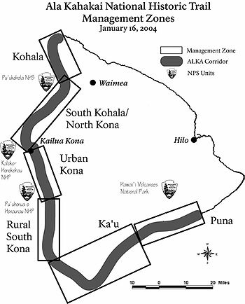
The trail follows the coastline over ancient fishermen's trails through over 200 ahupuaa, the traditional sea to mountain land divisions.
In ancient times travel would often cover both land, and sea in canoes for portions of the journey.
It passes through both public and private lands, providing access to numerous beaches and resorts.
Much of the trail receives only limited maintenance and sections have been eroded or developed into roads. Only the one section of the trail has signage.
The Northern end of the trail is in Upolu Point
in the North Kohala District at the Mookini Heiau, coordinates 20.25767°N 155.87707°W.
A part of the trail called Ala Loa (meaning "long trail" in the Hawaiian Language, another name for the same network of trails) was added to the state registry of historic places as site 10-10-11,334 on January 14, 1989, and to the National Register of Historic Places
as number 87001127 in 1987. This runs from Kiholo Bay to Kalahuipauaa near Puakō.
After passing through the west side of island, the trail ends in Hawaii Volcanoes National Park
.
Starting in 2002, a comprehensive management plan and environmental impact statement were prepared and published in 2008.
Trail
A trail is a path with a rough beaten or dirt/stone surface used for travel. Trails may be for use only by walkers and in some places are the main access route to remote settlements...
located on the island of Hawaii
Hawaii (island)
The Island of Hawaii, also called the Big Island or Hawaii Island , is a volcanic island in the North Pacific Ocean...
. It is not yet a continuous "trail", but can be accessed at several broken segments along the coastline of the Big Island. The trail was established to access the traditional Ancient Hawaii
Ancient Hawaii
Ancient Hawaii refers to the period of Hawaiian human history preceding the unification of the Kingdom of Hawaii by Kamehameha the Great in 1810. After being first settled by Polynesian long-distance navigators sometime between AD 300–800, a unique culture developed. Diversified agroforestry and...
an culture along with the natural geology
Geology
Geology is the science comprising the study of solid Earth, the rocks of which it is composed, and the processes by which it evolves. Geology gives insight into the history of the Earth, as it provides the primary evidence for plate tectonics, the evolutionary history of life, and past climates...
of the island. Currently managed under the National Park Service
National Park Service
The National Park Service is the U.S. federal agency that manages all national parks, many national monuments, and other conservation and historical properties with various title designations...
, the trail was established in 2000 as a National Historic Trail
National Historic Trail
National Historic Trail is a designation for a protected area in the United States containing historic trails and surrounding areas. They are part of the National Trails System....
.
Geography
Ala kaha kai means "shoreline trail" in the Hawaiian LanguageHawaiian language
The Hawaiian language is a Polynesian language that takes its name from Hawaii, the largest island in the tropical North Pacific archipelago where it developed. Hawaiian, along with English, is an official language of the state of Hawaii...
.
The trail follows the coastline over ancient fishermen's trails through over 200 ahupuaa, the traditional sea to mountain land divisions.
In ancient times travel would often cover both land, and sea in canoes for portions of the journey.
It passes through both public and private lands, providing access to numerous beaches and resorts.
Much of the trail receives only limited maintenance and sections have been eroded or developed into roads. Only the one section of the trail has signage.
The Northern end of the trail is in Upolu Point
Upolu Point
Upolu Point is the most northern point on the island of Hawaii in the Hawaiian Islands. It is an extruding landform created by cooled lava from an old eruption from Kohala volcano. The main town on the extrusion is Hawi, Hawaii about 2 miles inland...
in the North Kohala District at the Mookini Heiau, coordinates 20.25767°N 155.87707°W.
A part of the trail called Ala Loa (meaning "long trail" in the Hawaiian Language, another name for the same network of trails) was added to the state registry of historic places as site 10-10-11,334 on January 14, 1989, and to the National Register of Historic Places
National Register of Historic Places
The National Register of Historic Places is the United States government's official list of districts, sites, buildings, structures, and objects deemed worthy of preservation...
as number 87001127 in 1987. This runs from Kiholo Bay to Kalahuipauaa near Puakō.
After passing through the west side of island, the trail ends in Hawaii Volcanoes National Park
Hawaii Volcanoes National Park
Hawaii Volcanoes National Park, established in 1916, is a United States National Park located in the U.S. State of Hawaii on the island of Hawaii. It encompasses two active volcanoes: Kīlauea, one of the world's most active volcanoes, and Mauna Loa, the world's most massive volcano...
.
Starting in 2002, a comprehensive management plan and environmental impact statement were prepared and published in 2008.
Trail map