
Aitkin County, Minnesota
Encyclopedia
Aitkin County is a county located in the U.S. state
of Minnesota
. As of 2010, the population is 16,202. Its county seat
is Aitkin
. A portion of the Mille Lacs Indian Reservation
is in the county.
, a fur trader for the American Fur Company
, under John Jacob Astor
. Formed from Ramsey
and Pine
counties, Aiken County originally consisted of the 17 townships
closest to Mille Lacs Lake
. It acquired out-lands of Ramsey, Itasca
and Pine Counties to its north and east. It was reorganized in 1871, taking up lands from Cass
and Itasca Counties and losing a point located in the southwestern corner to Crow Wing
County to form its current boundaries.
 As of the census
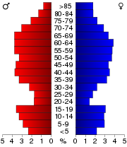
of 2010, there were 16,202 people, 7,542 households, and 4,458 families residing in the county. The population density
was 8.9 people per square mile (3/km²). There were 16,626 housing units at an average density of 8 per square mile (3/km²). The racial makeup of the county was 95.6% White
, 0.4% Black
or African American
, 2.4% Native American
, 0.2% Asian
, 0% Pacific Islander
, 0.16% from other races
, and 1.3% from two or more races. 0.9% of the population were Hispanic
or Latino
of any race. 29.5% were of German, 14.3% Norwegian, 13.0% Swedish, 6.2% Irish
, 5.3% United States
or American and 5.2% Finnish ancestry.
There were 6,644 households out of which 22.60% had children under the age of 18 living with them, 57.50% were married couples
living together, 6.30% had a female householder with no husband present, and 32.90% were non-families. 28.70% of all households were made up of individuals and 14.00% had someone living alone who was 65 years of age or older. The average household size was 2.28 and the average family size was 2.76.
In the county the population was spread out with 20.90% under the age of 18, 5.50% from 18 to 24, 21.60% from 25 to 44, 29.10% from 45 to 64, and 23.00% who were 65 years of age or older. The median age was 46 years. For every 100 females there were 101.60 males. For every 100 females age 18 and over, there were 99.90 males.
The median income for a household in the county was $44,139, and the median income for a family was $58,290. Males had a median income of $51,604 versus $30,633 for females. The per capita income
for the county was $21,848. About 5.20% of families and 7.60% of the population were below the poverty line, including 15.50% of those under age 18 and 11.00% of those age 65 or over.
On ePodunk : Aitkin County & Aitkin Cty. ancestry
U.S. state
A U.S. state is any one of the 50 federated states of the United States of America that share sovereignty with the federal government. Because of this shared sovereignty, an American is a citizen both of the federal entity and of his or her state of domicile. Four states use the official title of...
of Minnesota
Minnesota
Minnesota is a U.S. state located in the Midwestern United States. The twelfth largest state of the U.S., it is the twenty-first most populous, with 5.3 million residents. Minnesota was carved out of the eastern half of the Minnesota Territory and admitted to the Union as the thirty-second state...
. As of 2010, the population is 16,202. Its county seat
County seat
A county seat is an administrative center, or seat of government, for a county or civil parish. The term is primarily used in the United States....
is Aitkin
Aitkin, Minnesota
As of the census of 2000, there were 1,984 people, 892 households, and 434 families residing in the city. The population density was 1,150.3 people per square mile . There were 969 housing units at an average density of 561.8 per square mile...
. A portion of the Mille Lacs Indian Reservation
Mille Lacs Indian Reservation
Mille Lacs Indian Reservation is the land-base for the Mille Lacs Band of Ojibwe in Central Minnesota, about 100 miles north of Minneapolis-St. Paul...
is in the county.
History
Aitkin County was established in 1857 as Aiken County and had a spelling change of its name to the current spelling in 1872. Aitkin County was named after William Alexander AitkenWilliam Alexander Aitken
William Alexander Aitken, also known as William Alexander Aitkin , was a fur trader with the Ojibwe.-Biography:Aitken was apparently a native of Edinburgh, Scotland. He came to the Upper Mississippi region around 1802 from Canada and was employed by John Drew, a trader in the Mackinac area...
, a fur trader for the American Fur Company
American Fur Company
The American Fur Company was founded by John Jacob Astor in 1808. The company grew to monopolize the fur trade in the United States by 1830, and became one of the largest businesses in the country. The company was one the first great trusts in American business...
, under John Jacob Astor
John Jacob Astor
John Jacob Astor , born Johann Jakob Astor, was a German-American business magnate and investor who was the first prominent member of the Astor family and the first multi-millionaire in the United States...
. Formed from Ramsey
Ramsey County, Minnesota
Ramsey County is a county located in the U.S. state of Minnesota, founded in 1849. As of 2010, the population was 508,640. Its county seat is St. Paul, which is also Minnesota's state capital. The county is named for Alexander Ramsey , the first governor of the Minnesota Territory...
and Pine
Pine County, Minnesota
As of the census of 2000, there were 26,530 people, 9,939 households, and 6,917 families residing in the county. The population density was 19 people per square mile . There were 15,353 housing units at an average density of 11 per square mile...
counties, Aiken County originally consisted of the 17 townships
Township (United States)
A township in the United States is a small geographic area. Townships range in size from 6 to 54 square miles , with being the norm.The term is used in three ways....
closest to Mille Lacs Lake
Mille Lacs Lake
Mille Lacs Lake is a lake in the U.S. state of Minnesota. It is located in the counties of Mille Lacs, Aitkin and Crow Wing, roughly 100 miles north of the Minneapolis-St. Paul metropolitan area....
. It acquired out-lands of Ramsey, Itasca
Itasca County, Minnesota
Itasca County is a county located in the U.S. state of Minnesota. It is named after Lake Itasca, which is in turn a shortened version the Latin words veritas caput, meaning 'truth' and 'head', a reference to the source of the Mississippi River. As of 2010, the population was 45,058. Its county seat...
and Pine Counties to its north and east. It was reorganized in 1871, taking up lands from Cass
Cass County, Minnesota
Cass County is a county located in the U.S. state of Minnesota. As of 2010, the population was 28,567. Its county seat is Walker. A portion of the Leech Lake Indian Reservation is in the county.-Geography:...
and Itasca Counties and losing a point located in the southwestern corner to Crow Wing
Crow Wing County, Minnesota
Crow Wing County is a county located in the U.S. state of Minnesota. As of 2010, the population was 62,500. Its county seat is Brainerd.-Geography:...
County to form its current boundaries.
Geography
According to the 2000 census, the county has a total area of 1995.31 square miles (5,167.8 km²), of which 1819.3 square miles (4,712 km²) (or 91.18%) is land and 176.01 square miles (455.9 km²) (or 8.82%) is water.Major highways
|
 Minnesota State Highway 65 Minnesota State Highway 65Minnesota State Highway 65 Minnesota State Highway 65 is a highway in east-central and northeast Minnesota, which runs from its intersection with Washington Avenue at the north end of downtown Minneapolis and continues north to its northern terminus at its intersection with U.S...  Minnesota State Highway 200 Minnesota State Highway 200Minnesota State Highway 200 Minnesota State Highway 200 is a highway in northwest and northeast Minnesota,which runs from North Dakota Highway 200 at the North Dakota state line near Halstad, and continues east to its eastern terminus at its intersection with U.S...  Minnesota State Highway 210 Minnesota State Highway 210Minnesota State Highway 210 Minnesota State Highway 210 is a highway in west-central, central, and northeast Minnesota, which runs from North Dakota Highway 210 at the North Dakota state line , and continues east to its eastern terminus at its intersection with State Highway 23 in Duluth near the Saint Louis River.The route...  Minnesota State Highway 232 Minnesota State Highway 232Minnesota State Highway 232 Minnesota State Highway 232 is a highway in northeast Minnesota, which runs from its intersection with Aitkin County Road 3 in Palisade and continues east to its eastern terminus at its intersection with State Highway 65 and Aitkin County Road 14 in Shamrock Township, near Big Sandy Lake and the... |
 U.S. Highway 169

Adjacent counties
- Itasca CountyItasca County, MinnesotaItasca County is a county located in the U.S. state of Minnesota. It is named after Lake Itasca, which is in turn a shortened version the Latin words veritas caput, meaning 'truth' and 'head', a reference to the source of the Mississippi River. As of 2010, the population was 45,058. Its county seat...
(north) - St. Louis CountySt. Louis County, MinnesotaSt. Louis County is a county located in the U.S. state of Minnesota. As of 2010, the population was 200,226. Its county seat is Duluth. It is the largest county by total area in Minnesota, and the second largest in the United States east of the Mississippi River; in land area alone, after Aroostook...
(northeast) - Carlton CountyCarlton County, MinnesotaAs of the census of 2000, there were 31,671 people, 12,064 households, and 8,408 families residing in the county. The population density was 37 people per square mile . There were 13,721 housing units at an average density of 16 per square mile...
(east) - Pine CountyPine County, MinnesotaAs of the census of 2000, there were 26,530 people, 9,939 households, and 6,917 families residing in the county. The population density was 19 people per square mile . There were 15,353 housing units at an average density of 11 per square mile...
(southeast) - Kanabec County (south)
- Mille Lacs CountyMille Lacs County, MinnesotaAs of the census of 2000, there were 22,330 people, 8,638 households, and 6,003 families residing in the county. The population density was 39 people per square mile . There were 10,467 housing units at an average density of 18 per square mile...
(south) - Crow Wing CountyCrow Wing County, MinnesotaCrow Wing County is a county located in the U.S. state of Minnesota. As of 2010, the population was 62,500. Its county seat is Brainerd.-Geography:...
(southwest) - Cass CountyCass County, MinnesotaCass County is a county located in the U.S. state of Minnesota. As of 2010, the population was 28,567. Its county seat is Walker. A portion of the Leech Lake Indian Reservation is in the county.-Geography:...
(northwest)
Climate and weather
In recent years, average temperatures in the county seat of Aitkin have ranged from a low of 0 °F (-17.8 °C) in January to a high of 80 °F (26.7 °C) in July, although a record low of -47 °F was recorded in January 1972 and a record high of 100 °F (37.8 °C) was recorded in August 1976. Average monthly precipitation ranged from 0.79 inches (2 cm) in February to 4.46 inches (11.3 cm) in June.Demographics
Census
A census is the procedure of systematically acquiring and recording information about the members of a given population. It is a regularly occurring and official count of a particular population. The term is used mostly in connection with national population and housing censuses; other common...
of 2010, there were 16,202 people, 7,542 households, and 4,458 families residing in the county. The population density
Population density
Population density is a measurement of population per unit area or unit volume. It is frequently applied to living organisms, and particularly to humans...
was 8.9 people per square mile (3/km²). There were 16,626 housing units at an average density of 8 per square mile (3/km²). The racial makeup of the county was 95.6% White
Race (United States Census)
Race and ethnicity in the United States Census, as defined by the Federal Office of Management and Budget and the United States Census Bureau, are self-identification data items in which residents choose the race or races with which they most closely identify, and indicate whether or not they are...
, 0.4% Black
Race (United States Census)
Race and ethnicity in the United States Census, as defined by the Federal Office of Management and Budget and the United States Census Bureau, are self-identification data items in which residents choose the race or races with which they most closely identify, and indicate whether or not they are...
or African American
Race (United States Census)
Race and ethnicity in the United States Census, as defined by the Federal Office of Management and Budget and the United States Census Bureau, are self-identification data items in which residents choose the race or races with which they most closely identify, and indicate whether or not they are...
, 2.4% Native American
Race (United States Census)
Race and ethnicity in the United States Census, as defined by the Federal Office of Management and Budget and the United States Census Bureau, are self-identification data items in which residents choose the race or races with which they most closely identify, and indicate whether or not they are...
, 0.2% Asian
Race (United States Census)
Race and ethnicity in the United States Census, as defined by the Federal Office of Management and Budget and the United States Census Bureau, are self-identification data items in which residents choose the race or races with which they most closely identify, and indicate whether or not they are...
, 0% Pacific Islander
Race (United States Census)
Race and ethnicity in the United States Census, as defined by the Federal Office of Management and Budget and the United States Census Bureau, are self-identification data items in which residents choose the race or races with which they most closely identify, and indicate whether or not they are...
, 0.16% from other races
Race (United States Census)
Race and ethnicity in the United States Census, as defined by the Federal Office of Management and Budget and the United States Census Bureau, are self-identification data items in which residents choose the race or races with which they most closely identify, and indicate whether or not they are...
, and 1.3% from two or more races. 0.9% of the population were Hispanic
Race (United States Census)
Race and ethnicity in the United States Census, as defined by the Federal Office of Management and Budget and the United States Census Bureau, are self-identification data items in which residents choose the race or races with which they most closely identify, and indicate whether or not they are...
or Latino
Race (United States Census)
Race and ethnicity in the United States Census, as defined by the Federal Office of Management and Budget and the United States Census Bureau, are self-identification data items in which residents choose the race or races with which they most closely identify, and indicate whether or not they are...
of any race. 29.5% were of German, 14.3% Norwegian, 13.0% Swedish, 6.2% Irish
Irish people
The Irish people are an ethnic group who originate in Ireland, an island in northwestern Europe. Ireland has been populated for around 9,000 years , with the Irish people's earliest ancestors recorded having legends of being descended from groups such as the Nemedians, Fomorians, Fir Bolg, Tuatha...
, 5.3% United States
United States
The United States of America is a federal constitutional republic comprising fifty states and a federal district...
or American and 5.2% Finnish ancestry.
There were 6,644 households out of which 22.60% had children under the age of 18 living with them, 57.50% were married couples
Marriage
Marriage is a social union or legal contract between people that creates kinship. It is an institution in which interpersonal relationships, usually intimate and sexual, are acknowledged in a variety of ways, depending on the culture or subculture in which it is found...
living together, 6.30% had a female householder with no husband present, and 32.90% were non-families. 28.70% of all households were made up of individuals and 14.00% had someone living alone who was 65 years of age or older. The average household size was 2.28 and the average family size was 2.76.
In the county the population was spread out with 20.90% under the age of 18, 5.50% from 18 to 24, 21.60% from 25 to 44, 29.10% from 45 to 64, and 23.00% who were 65 years of age or older. The median age was 46 years. For every 100 females there were 101.60 males. For every 100 females age 18 and over, there were 99.90 males.
The median income for a household in the county was $44,139, and the median income for a family was $58,290. Males had a median income of $51,604 versus $30,633 for females. The per capita income
Per capita income
Per capita income or income per person is a measure of mean income within an economic aggregate, such as a country or city. It is calculated by taking a measure of all sources of income in the aggregate and dividing it by the total population...
for the county was $21,848. About 5.20% of families and 7.60% of the population were below the poverty line, including 15.50% of those under age 18 and 11.00% of those age 65 or over.
On ePodunk : Aitkin County & Aitkin Cty. ancestry
Cities and towns
| Cities | Townships | Unorganized | Unincorporated Communities | ||
|---|---|---|---|---|---|
|
|
|
|
|
|
External links
- Aitkin County government’s website
- Minnesota Department of TransportationMinnesota Department of TransportationThe Minnesota Department of Transportation oversees transportation by land, water, and air in the U.S. state of Minnesota. The cabinet-level agency is responsible for maintaining the state's trunk highway system The Minnesota Department of Transportation (Mn/DOT, pronounced "min-dot") oversees...
map of Aitkin County (southern portion, northern portion)