Air Defense Identification Zone
Encyclopedia

Air Defense Identification Zone
An Air Defense Identification Zone has existed since February 10, 2003, around the Baltimore-Washington Metropolitan Area to restrict air traffic near Washington, D.C....
(ADIZ) has existed since February 10, 2003, around the Baltimore-Washington Metropolitan Area
Baltimore-Washington Metropolitan Area
The Baltimore-Washington Metropolitan Area is a combined statistical area consisting of the overlapping labor market region of the cities of Baltimore, Maryland and Washington, D.C.. The region includes Central Maryland, Northern Virginia, and Jefferson County in the Eastern Panhandle of West...
to restrict air traffic near Washington, D.C.
Washington, D.C.
Washington, D.C., formally the District of Columbia and commonly referred to as Washington, "the District", or simply D.C., is the capital of the United States. On July 16, 1790, the United States Congress approved the creation of a permanent national capital as permitted by the U.S. Constitution....
The ADIZ was established after the September 11 attacks as a temporary measure to prevent further attacks. It was made permanent in 2008.
Despite efforts by the Federal Aviation Administration
Federal Aviation Administration
The Federal Aviation Administration is the national aviation authority of the United States. An agency of the United States Department of Transportation, it has authority to regulate and oversee all aspects of civil aviation in the U.S...
to inform pilots of the ADIZ, there are still many unauthorized incursions by unsuspecting pilots. A pilot who violates the boundaries may be intercepted by military aircraft and escorted to the nearest airport, followed by suspension or revocation of the pilot's certificates.
Creation
The ADIZ (now known collectively as a Flight Restricted Zone and Special Flight Rules Area) was created by the FAA in response to demands by a working group that became formalized as the National Capital Region Coordination Center. The U.S. Congress has never legitimized these restrictions, and any consideration of opposing the Executive Branch's actions became politically unpalatable in the wake of two mishaps that led to the evacuation of the CapitolUnited States Capitol
The United States Capitol is the meeting place of the United States Congress, the legislature of the federal government of the United States. Located in Washington, D.C., it sits atop Capitol Hill at the eastern end of the National Mall...
. One involved a plane carrying Ernie Fletcher
Ernie Fletcher
Ernest Lee "Ernie" Fletcher is a Republican politician from the U.S. state of Kentucky. In 1999, he was elected to the first of three consecutive terms in the United States House of Representatives; he resigned in 2003 after being elected the 60th governor of Kentucky and served in that office...
, the Governor of Kentucky
Governor of Kentucky
The Governor of the Commonwealth of Kentucky is the head of the executive branch of government in the U.S. state of Kentucky. Fifty-six men and one woman have served as Governor of Kentucky. The governor's term is four years in length; since 1992, incumbents have been able to seek re-election once...
. The other, almost a year later, involved a Cessna 150
Cessna 150
The Cessna 150 is a two-seat tricycle gear general aviation airplane, that was designed for flight training, touring and personal use.The Cessna 150 is the seventh most produced civilian plane ever, with 23,839 aircraft produced...
flown by a student pilot accompanied by a pilot who was not familiar with the ADIZ rules, using an outdated chart.
Flight Restricted Zone
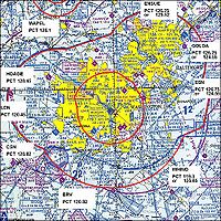
Within the ADIZ is an even more sensitive zone designated the Washington, D.C. Metropolitan Area Flight Restricted Zone (DC FRZ). The DC FRZ extends approximately 13-15 nautical miles (15-17 statute miles) around the VORVHF omnidirectional range
VOR, short for VHF omnidirectional radio range, is a type of radio navigation system for aircraft. A VOR ground station broadcasts a VHF radio composite signal including the station's identifier, voice , and navigation signal. The identifier is typically a two- or three-letter string in Morse code...
/DME
Distance Measuring Equipment
Distance measuring equipment is a transponder-based radio navigation technology that measures distance by timing the propagation delay of VHF or UHF radio signals....
located at the Ronald Reagan Washington National Airport
Ronald Reagan Washington National Airport
Ronald Reagan Washington National Airport is a public airport located south of downtown Washington, D.C., in Arlington County, Virginia. It is the commercial airport nearest to Washington, D.C. For many decades, it was called Washington National Airport, but this airport was renamed in 1998 to...
. Flight within the FRZ is restricted to governmental, certain scheduled commercial and a limited set of waivered flights. Three general aviation airports (known as the "Maryland 3" or the "DC 3") are located inside the DC FRZ. The "Maryland 3" are College Park Airport
College Park Airport
College Park Airport is a public airport located in the City of College Park, in Prince Georges County, Maryland, USA. It is the world's oldest continuously operated airport.-History:...
(CGS), Washington Executive/Hyde Field
Washington Executive Airport
Washington Executive Airport , also known as Hyde Field, is a public use general aviation airport located two miles southwest of the central business district of Clinton, in Prince Georges County, Maryland, USA...
(W32), and Potomac Airport
Potomac Airfield
Potomac Airfield , also known as Potomac Airport or Potomac Airpark, is a privately-owned, public-use airport located in the community of Fort Washington , in Prince Georges County, Maryland, United States...
(VKX).

Public opposition
Pilots' groups, led by the Aircraft Owners and Pilots AssociationAircraft Owners and Pilots Association
The Aircraft Owners and Pilots Association is a Frederick, Maryland-based non-profit political organization. Incorporated on 15 May 1939, AOPA's membership consists mainly of general aviation pilots in the United States...
(AOPA), have argued that the ADIZ is unnecessary and has a harmful effect on the economy of small airports and aviation-related businesses in and near the ADIZ. Pilots involved in law enforcement have described the ADIZ as a "major, unnecessary burden on pilots and air traffic controllers with almost no increased security benefit." AOPA and other groups are hoping to persuade Congress to lift or ease the ADIZ restrictions from Washington airspace http://www.aopa.org/adizalert -- or at the very least to dramatically improve its operational aspects.
In 2006 the FAA issued a Notice of Proposed Rulemaking
Notice of proposed rulemaking
A notice of proposed rulemaking is a public notice issued by law when one of the independent agencies of the United States government wishes to add, remove, or change a rule or regulation as part of the rulemaking process. It is an important part of United States administrative law which...
(NPRM) docket number 17005 concerning making the temporary rules permanent. Over 20,000 responses were received the vast majority of them in opposition to making the temporary rules permanent. There were two public hearings held by the FAA in the Washington D.C. area on the NPRM. All speakers were opposed to making the NPRM permanent. The FAA published transcripts of the public hearings. The transcripts were later withdrawn from the public as they were alleged to contain Sensitive Security Information, but were returned following review.
Subsequent Changes
On August 30, 2007, the FAA implemented new rules for air traffic controllers and issued revised NOTAMs for pilots flying in the ADIZ. Although the NOTAMs and FAA procedures state that no radar services will be provided to pilots unless requested, air traffic controllers at Potomac TRACON are providing such services. This is due to a memorandum from the Potomac TRACON Air Traffic Manager to air traffic controllers stating that a certain paragraph (2-1-2) of the Air Traffic Control handbook (7110.65) is still applicable when providing ATC Security Services. This has been translated, by some air traffic controllers, that traffic advisories are required.On February 9, 2009, any pilots flying VFR
Visual flight rules
Visual flight rules are a set of regulations which allow a pilot to operate an aircraft in weather conditions generally clear enough to allow the pilot to see where the aircraft is going. Specifically, the weather must be better than basic VFR weather minimums, as specified in the rules of the...
within a 60 nautical miles (111.1 km) radius centered on the ADIZ will be required to complete training about the ADIZ. This training can be completed online through a course called "Navigating the New DC ADIZ". Pilots may also complete the required training by attending a seminar offered at a Flight Standards District Office
Flight Standards District Office
A Flight Standards District Office, or FSDO, usually pronounced FIZ-doe, is a regional office of the United States Federal Aviation Administration...
. Pilots must obtain a certificate which proves that the training has been completed. This certificate is not required to be carried with the pilot, but must be produced when requested from law enforcement or other agencies. Pilots flying IFR are not subject to this requirement.
On February 17, 2009, the status of the ADIZ was scheduled to change from a Temporary Flight Restriction to a permanent Special Flight Rules Area
Special Flight Rules Area
In United States aviation, a Special Flight Rules Area is a region in which the normal regulations of flight do not apply in whole or in part, especially regulations concerning airspace classification, altitude, course, and speed restrictions, and the like.Examples of SFRAs include those...
. On February 6, 2009, White House officials declined a request to postpone the implementation.
Original District of Columbia ADIZ
The original Washington ADIZ was somewhat larger and was roughly co-extensive with the Airspace classAirspace class
The world's navigable airspace is divided into three-dimensional segments, each of which is assigned to a specific class. Most nations adhere to the classification specified by the International Civil Aviation Organization and described below...
airspace around Washington. On August 30, 2007, the ADIZ was changed to a circle surrounding Washington, D.C., with a radius of 30 nautical miles (55.6 km), with a small triangular cutout for Leesburg Executive Airport
Leesburg Executive Airport
Leesburg Executive Airport at Godfrey Field is a town-owned public-use airport located three nautical miles south of the central business district of Leesburg, a town in Loudoun County, Virginia, United States....
. This change reduced the size of the ADIZ by 1800 square miles (4,662 km²) and removed 33 airports from its coverage.