
Abajo Mountains
Encyclopedia
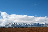
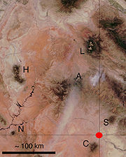
The Abajo Mountains, also called the Blue Mountains, is a small mountain range west of Monticello, Utah
, south of Canyonlands National Park
and north of Blanding, Utah
. The mountain range is located within the Manti-La Sal National Forest
. The highest peak within the range is Abajo Peak
at 11360 feet (3,463 m).
This mountain range, like both the La Sal Range
and Henry Mountains
in the same part of the Colorado Plateau
, is formed about igneous intrusions that are relatively resistant to erosion. Some of these intrusions form laccolith
s emplaced at depths of a few kilometers. The predominant igneous rock is porphyritic hornblende
diorite
. Ages of intrusion in the Abajo Mountains fall in the interval from 22 to 29 million years. These mountain ranges are part of the Colorado Plateau
province and part of the Rocky Mountain system, west of the greater ranges of the Rocky Mountains
.
The name "Abajo" comes from a Spanish word meaning "low".
Monticello, Utah
Monticello is a city located in San Juan County, Utah, and is the county seat. It is the second most populous city in San Juan County, with a population of 1,958 at the 2000 census. The Monticello area was settled in July 1887 by pioneers from The Church of Jesus Christ of Latter-day Saints...
, south of Canyonlands National Park
Canyonlands National Park
Canyonlands National Park is a U.S. National Park located in southeastern Utah near the town of Moab and preserves a colorful landscape eroded into countless canyons, mesas and buttes by the Colorado River, the Green River, and their respective tributaries. The park is divided into four districts:...
and north of Blanding, Utah
Blanding, Utah
Blanding is a city in San Juan County, Utah, United States. The population was 3,162 at the 2000 census, making it the most populated city in San Juan County. It was settled in the late 19th century by Mormon settlers, predominantly from the famed Hole-In-The-Rock expedition...
. The mountain range is located within the Manti-La Sal National Forest
Manti-La Sal National Forest
The Manti-La Sal National Forest covers 1,270,646 acres and is located in the central and southeastern parts of the U.S. state of Utah and the extreme western part of Colorado...
. The highest peak within the range is Abajo Peak
Abajo Peak
Abajo Peak is the highest peak in the Abajo Mountains of southeast Utah and is located, in the Manti-La Sal National Forest. The summit is southwest of Monticello, Utah and west of the Colorado border. The summit provides a panoramic view of southeastern Utah, Colorado, and the Four Corners...
at 11360 feet (3,463 m).
This mountain range, like both the La Sal Range
La Sal Range
The La Sal Mountains are located in Grand and San Juan counties, near the eastern border of the state of Utah, and rising above the town of Moab. This range is part of the Manti-La Sal National Forest and the southern Rocky Mountains. The maximum elevation is at Mount Peale, reaching 12,721 feet ...
and Henry Mountains
Henry Mountains
The Henry Mountains are located in the southeastern portion of the U.S. state of Utah and run in a generally north-south direction, extending over a distance of about 30 miles . They were named by John Wesley Powell in honour of Joseph Henry, the first secretary of the Smithsonian Institution. The...
in the same part of the Colorado Plateau
Colorado Plateau
The Colorado Plateau, also called the Colorado Plateau Province, is a physiographic region of the Intermontane Plateaus, roughly centered on the Four Corners region of the southwestern United States. The province covers an area of 337,000 km2 within western Colorado, northwestern New Mexico,...
, is formed about igneous intrusions that are relatively resistant to erosion. Some of these intrusions form laccolith
Laccolith
A laccolith is a sheet intrusion that has been injected between two layers of sedimentary rock. The pressure of the magma is high enough that the overlying strata are forced upward, giving the laccolith a dome or mushroom-like form with a generally planar base.Laccoliths tend to form at relatively...
s emplaced at depths of a few kilometers. The predominant igneous rock is porphyritic hornblende
Hornblende
Hornblende is a complex inosilicate series of minerals .It is not a recognized mineral in its own right, but the name is used as a general or field term, to refer to a dark amphibole....
diorite
Diorite
Diorite is a grey to dark grey intermediate intrusive igneous rock composed principally of plagioclase feldspar , biotite, hornblende, and/or pyroxene. It may contain small amounts of quartz, microcline and olivine. Zircon, apatite, sphene, magnetite, ilmenite and sulfides occur as accessory...
. Ages of intrusion in the Abajo Mountains fall in the interval from 22 to 29 million years. These mountain ranges are part of the Colorado Plateau
Colorado Plateau
The Colorado Plateau, also called the Colorado Plateau Province, is a physiographic region of the Intermontane Plateaus, roughly centered on the Four Corners region of the southwestern United States. The province covers an area of 337,000 km2 within western Colorado, northwestern New Mexico,...
province and part of the Rocky Mountain system, west of the greater ranges of the Rocky Mountains
Rocky Mountains
The Rocky Mountains are a major mountain range in western North America. The Rocky Mountains stretch more than from the northernmost part of British Columbia, in western Canada, to New Mexico, in the southwestern United States...
.
The name "Abajo" comes from a Spanish word meaning "low".