

A215 road
Encyclopedia
The A215 is an A road in South London
, from Elephant and Castle
to Shirley
. It runs through the London Boroughs
of Lambeth
, Southwark
and Croydon
.
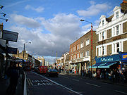
Beginning as Walworth Road, the A215 becomes Camberwell Road—much of which is a conservation area—after entering the former Metropolitan Borough of Camberwell
. Crossing the A202, the A215 becomes Denmark Hill, originally known as Dulwich Hill, but renamed in 1683 to commemorate the marriage of Princess Anne (later Queen Anne
) to Prince George of Denmark. After passing Herne Hill railway station
the road becomes Norwood Road, Knights Hill, and then Beulah Hill at its crossroads with the A214. Beulah Hill was the site of Britain's first independent television transmitter, built by the Independent Television Authority
in 1955. Descending towards South Norwood
the A215 becomes South Norwood Hill and then Portland Road, just after crossing the A213. A short section starting at the junction with Woodside Green is known as Spring Lane, leading to Shirley Road, the final section into Shirley
, Croydon
.
, the A215 begins as Walworth Road, which runs between Elephant and Castle
and Camberwell Road. It runs through Walworth
and is the major shopping street of the area. East Street Market
is especially busy on Fridays, Saturdays and Sundays. Other attractions include the Cuming Museum
, Newington Reference Library and John Smith House, a former Labour Party
headquarters which is now used by the local education authority
.
 Charles Babbage
, the Victorian
mathematician and computer pioneer, was probably born at 44 Crosby Row, now Larcom Street, Walworth Road on 26 December 1791. A commemorative blue plaque
is displayed on the Sexual Health Clinic at the junction of Larcom Street and Walworth Road.
Just off the Walworth Road was Walworth Road railway station
on the London, Chatham and Dover Railway
that was opened in 1863 and shut in 1916 due to wartime constraints.
 Walworth Road transitions into Camberwell Road where the A215 enters the former Metropolitan Borough of Camberwell
. The road runs adjacent to the railway between Elephant & Castle tube station
and Loughborough Junction railway station
. Much of Camberwell Road is a conservation area
, due to its well preserved large houses from the early 19th century.
By the time of the Domesday Book
, Camberwell was already a significant settlement. The town remained a popular resort for Londoners due to its believed medicinal wells
. In 1685, John Evelyn
's Diary
mentions a Roman urn filled with bones which was uncovered intact during repairs to the road and exhibited at the Royal Society
.
Camberwell Green
, at the junction of Camberwell Road and Camberwell Church Street, was the traditional site of Camberwell Fair, an annual fair held every August. Following complaints about the noise and high crime levels generated by the fair, a group of residents bought the fairground in 1855, converting it into the park which remains today.
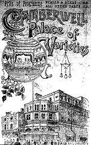
In Victorian
times Camberwell Road was a focal point of South London's Music hall
scene, with a number of music halls opening from the 1850s onwards. Following the advent of the cinema
and later of television
, the music halls fell into decline, with the last closing in 1956. Nearby Orpheus Street marks the site of the Metropole Music Hall.
Since the New Works Programme
of the 1930s, London Transport
and its successors have planned to extend the Bakerloo Line
south to a station on Camberwell Road. The original plans were abandoned due to the war
before much construction had been completed. Construction again began in the 1950s and 1970s, but was abandoned each time. Transport for London
still intend to build this extension but no date has been set for this.
) to Prince George of Denmark. The road runs between Kings College Hospital and The Maudsley Hospital
before going alongside Ruskin Park. Further south the road passes the Denmark Hill Estate.
The Victorian art critic
, author and social critic John Ruskin
lived at 163 Denmark Hill from 1842 to 1871. The house no longer stands and is now the site of a block of council flats
. Ruskin Park, immediately south of the twin hospitals, is named in his honour.
Denmark Hill is home to two of London's largest hospital
s, the general King's College Hospital
(part of King's College London
) which moved to the site from its original central London location in 1913, and the Maudsley psychiatric hospital.
It is believed by historians that 168, 170 and 172 Denmark Hill were designed by noted architect and prison designer William Blackburn
due their similarity in architectural style to his other buildings. However, as the original documentation relating to the construction of these houses has been lost or destroyed, it has proved impossible to confirm this.
Immediately south of the Maudsley Hospital is Denmark Hill railway station
, built in 1866 and rebuilt following fire in 1980, on the South London Line. It is proposed that this will form part of the East London Line
westward extension to Clapham Junction as part of the London Overground
network.
. The origin of the name is disputed but possibly derives from heron
s nesting on the (now buried) River Effra
. The earliest known usage of the name "Herne Hill" dates from 1798.
St Paul's church was rebuilt in dramatic style by the gothic architect George Edmund Street
in 1858.
Herne Hill railway station
is at the southern end of Herne Hill, on a busy six-road junction. It opened in 1862 and was initially the southern terminus of the London, Chatham and Dover Railway
. It runs alongside Brockwell Park
and then south to Tulse Hill
.
A manor house known as "Brockholle" or "Brockhalle" (the origin of the name "Brockwell") was built on Norwood Road, on what is now a part of Brockwell Park, in the mid-15th century. In 1809 the building was bought by wealthy merchant and Sheriff of London
John Blades. Blades demolished the building, and built Brockwell Hall as a replacement at the top of the hill in the park; this building still stands today.
Tulse Hill railway station
is on this road. After passing the station, Norwood Road continues south past West Norwood Cemetery
(home of 65 Listed Monuments) to West Norwood
and the Norwood Triangle. Norwood Road is home to St Luke's Church
, a Grade II listed building designed by Francis Octavius Bedford
in 1823–5 and rebuilt by GE Street
in 1870.
The Regal Cinema opened on Norwood Road in January 1930; it was unusual in that it also staged live stage shows to accompany films (including performances by animals from circus
es visiting the nearby park). It was home to the Regal Redheads, a troupe of dancing girls who performed in the interval
. Norwood Road is a busy shopping street, and includes Olley's, one of the best known chip shops
in south London and Brockwell's Wine Bar, home of the famous weekly Caribbean Renaissance Jamaica
n-themed night.
in the Norwood Triangle one-way system, and runs through a council ward also named as Knight's Hill
. It ends in the south at a junction with the A214 at Crown Lane and Crown Dale. Knights Hill becomes Beulah Hill here at Crown Point. To the north, south of Knight's Hill is the part of the Crystal Palace area with no name home to a large parade of competing large super markets along the A215 Norwood Road including Tesco, Cooperative, Iceland and (by Summer 2009) Sainsbury (ex Woolworth's site). West Norwood railway station
is on this road. Knights Hill contains the Knights Hill Nature Reserve, one of the last remaining vestiges of the Great North Wood
which once covered the area.
The 1647 Parliamentary Survey described Knights Hill as "a small common wood containing 40 pollard oaks and two elms".
. On the sharp bend is the ornamental Beulah Hill Pond. Formerly "Big Pond", it was intended as a watering stop for horses and cattle using the road, and still contains a railing to prevent animals straying into deep water. The "Conquering Hero" pub was built next to the pond for the use of people stopping to allow livestock to use the pond, and remains today.
Nearby is St Joseph's College founded in 1855, one of the first Catholic educational institutions to be opened in England following the restoration of the Catholic hierarchy. Beulah Hill was the site of Britain's first independent television transmitter
, built by the Independent Television Authority
in 1955. Beulah Hill ends at a junction with the A212 (Church Road). From this junction, the A215 is called South Norwood Hill.
. It becomes Portland Road at the crossroads with the A213 road
. No longer hidden from view by the Esso petrol station, which was demolished in 2009, is the famous Spurgeon's College
, a theological college which since 1923 has been located in a mansion built in 1890 and known as Falkland Park. The former porter's lodge of the Falkland Park estate still stands along South Norwood Hill as no. 217, "Falkland Lodge". Otherwise this section is mainly residential.
 Portland Road begins at a crossroads where the A215 crosses the A213 on South Norwood High Street and South Norwood Hill becomes Portland Road. The road then travels down a hill with many shops (mainly takeaways, newsagents). It passes South Norwood Leisure Centre
, a new leisure centre which includes a creche, cafe, gym, swimming pool etc. Portland Road ends with a left turn to stay on the A215 at Spring Lane or straight on to change onto the B243, Woodside Green
. From June 2010, the road will be the site of a station on the new London Overground
network.
s and four pence was paid on the land between 1442–1483; this is the earliest recorded reference to the area. The road at the time ran through an ancient woodland
known as the North Wood (the origin of the modern place name Norwood
). The area was cleared for farmland in the 16th and 17th centuries. Industrial development began in the early 19th century following construction of the Grand Surrey Canal
, linking the area to Surrey Commercial Docks
and the River Thames
in 1809. This section of the canal was closed in 1836, with the London and Croydon Railway
built along the canal bed; modern housing development began in the mid 19th century following the opening of the railway.
 In 1839 the London and Croydon Railway
opened Jolly-sailor station
(sic)—listed as "Jolly-sailor near Beulah Spa" on fares lists and timetables—at the north end of the street. The station was renamed Norwood in 1846. The station was immediately adjacent to a level crossing
over Portland Road.
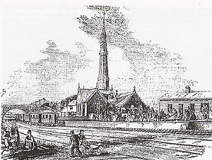
In 1844, the London and Croydon Railway was given parliamentary authority to test an experimental pneumatic propulsion
system on the railway (referred to at the time as the atmospheric-propulsion system). A pumping station was built on Portland Road; this created a vacuum
in a pipe paralleling the railway tracks. A piston extended downwards from the trains into a slit in the pipe, meaning that trains were literally sucked towards the pumping station or blown away from it. The pumping station was built in a Gothic
style, with a very tall ornate tower which served both as a chimney
and as an exhaust vent for air pumped from the propulsion pipe.
As part of the construction works for the atmospheric-propulsion system, the world's first railway flyover
was constructed at the north end of Portland Road, to carry the new atmospheric line over the conventional steam line below. In 1847, the atmospheric propulsion experiment was abandoned.
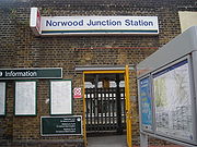
Following construction of new lines, the station closed on 1 June 1859 and was replaced by a new station on the south side of the road, Norwood Junction
, which is still in use, now part of the newly-extended East London Line
of the London Overground
which was opened on 23 May 2010.
in South London, the Electric Picture Palace, opened on Portland Road in 1910. The cinema was renamed the Central Cinema shortly afterwards, and closed in 1956, and no trace of it now remains.
Portland Road is also home to the "Gold Coast", the only Ghana
ian public house
in London; this is a focal point for London's Ghanaian community and serves Ghanaian beer, wine and food.
Roots, Routes, Roots (also known as the "Portland Road Mosaic"), an 11 metres (36.1 ft) long mosaic depicting the history of the Norwood
area, is under the railway bridge. The mosaic was designed by artists Gary Drostle and Rob Turner, and built by children from a number of local schools.
. St Luke's Church, Ashburton Park
, Ashburton Primary School and Woodside tram stop
are on this road.
Spring Lane was notable for many years in having one of the few Ancient lights notices in London outside central London, on a private house immediately opposite the station. The sign was taken down in 2005.
; the station is now Woodside tram stop
.
. It ends in Shirley
, Croydon
. Shirley Road skirts the nearby suburb of Addiscombe
. The town is named after the historic manor of Adscomb ("Edge of the valley"), the country seat of the Heron family, which was situated on Shirley Road. The building no longer exists.
are just off Shirley Road, behind the school. The fields were first dedicated as a public horse racing
course by James I
in the early 17th century. Following the opening of the nearby Woodside railway station
in 1871 large numbers of Londoners began travelling to the racecourse. Following pressure from the Mayor of Croydon
, concerned about the large crowds, the racecourse was closed in 1890 and replaced with a golf course
; this was bought by the council in 1942 and given to public use as playing fields.
South London
South London is the southern part of London, England, United Kingdom.According to the 2011 official Boundary Commission for England definition, South London includes the London boroughs of Bexley, Bromley, Croydon, Greenwich, Kingston, Lambeth, Lewisham, Merton, Southwark, Sutton and...
, from Elephant and Castle
Elephant and Castle
The Elephant and Castle is a major road intersection in south London, England, located in the London Borough of Southwark. It is also used as a name for the surrounding area....
to Shirley
Shirley, London
Shirley is a place in the London Borough of Croydon, England. It is a suburban development situated 10 miles south south-east of Charing Cross.-Description:...
. It runs through the London Boroughs
London borough
The administrative area of Greater London contains thirty-two London boroughs. Inner London comprises twelve of these boroughs plus the City of London. Outer London comprises the twenty remaining boroughs of Greater London.-Functions:...
of Lambeth
London Borough of Lambeth
The London Borough of Lambeth is a London borough in south London, England and forms part of Inner London. The local authority is Lambeth London Borough Council.-Origins:...
, Southwark
London Borough of Southwark
The London Borough of Southwark is a London borough in south east London, England. It is directly south of the River Thames and the City of London, and forms part of Inner London.-History:...
and Croydon
London Borough of Croydon
The London Borough of Croydon is a London borough in South London, England and is part of Outer London. It covers an area of and is the largest London borough by population. It is the southernmost borough of London. At its centre is the historic town of Croydon from which the borough takes its name...
.
Beginning as Walworth Road, the A215 becomes Camberwell Road—much of which is a conservation area—after entering the former Metropolitan Borough of Camberwell
Metropolitan Borough of Camberwell
Camberwell was a civil parish and metropolitan borough in the County of London. The borough was created in 1900 by the London Government Act 1899, covering the area of the ancient parish of Camberwell...
. Crossing the A202, the A215 becomes Denmark Hill, originally known as Dulwich Hill, but renamed in 1683 to commemorate the marriage of Princess Anne (later Queen Anne
Anne of Great Britain
Anne ascended the thrones of England, Scotland and Ireland on 8 March 1702. On 1 May 1707, under the Act of Union, two of her realms, England and Scotland, were united as a single sovereign state, the Kingdom of Great Britain.Anne's Catholic father, James II and VII, was deposed during the...
) to Prince George of Denmark. After passing Herne Hill railway station
Herne Hill railway station
Herne Hill railway station is in Herne Hill, a location in the London Borough of Lambeth, South London, England. Its location is .The station is above road level near the junction of five main roads, between Railton Road and Milkwood Road. There is no entrance in Milkwood Road, but there is a...
the road becomes Norwood Road, Knights Hill, and then Beulah Hill at its crossroads with the A214. Beulah Hill was the site of Britain's first independent television transmitter, built by the Independent Television Authority
Independent Television Authority
The Independent Television Authority was an agency created by the Television Act 1954 to supervise the creation of "Independent Television" , the first commercial television network in the United Kingdom...
in 1955. Descending towards South Norwood
South Norwood
South Norwood is an urban town and in south London, England, in the London Borough of Croydon. It is a suburban development 7.8 miles south-east of Charing Cross. South Norwood is an electoral with a resident population in 2001 of just over 14,000...
the A215 becomes South Norwood Hill and then Portland Road, just after crossing the A213. A short section starting at the junction with Woodside Green is known as Spring Lane, leading to Shirley Road, the final section into Shirley
Shirley, London
Shirley is a place in the London Borough of Croydon, England. It is a suburban development situated 10 miles south south-east of Charing Cross.-Description:...
, Croydon
London Borough of Croydon
The London Borough of Croydon is a London borough in South London, England and is part of Outer London. It covers an area of and is the largest London borough by population. It is the southernmost borough of London. At its centre is the historic town of Croydon from which the borough takes its name...
.
Walworth Road
At its northernmost point at Elephant & Castle in NewingtonNewington, London
Newington is a district of London, England, and part of the London Borough of Southwark. It was an ancient parish and the site of the early administration of the county of Surrey...
, the A215 begins as Walworth Road, which runs between Elephant and Castle
Elephant and Castle
The Elephant and Castle is a major road intersection in south London, England, located in the London Borough of Southwark. It is also used as a name for the surrounding area....
and Camberwell Road. It runs through Walworth
Walworth, London
Walworth is an inner-city district in the London Borough of Southwark. Walworth probably derives its name from the Old English "Wealhworth" which meant Welsh farm. It is located south east of Charing Cross and near to Camberwell and Elephant and Castle.The major streets in Walworth are the Old...
and is the major shopping street of the area. East Street Market
East Street Market
East Street Market also known locally as 'The Lane', or 'East Lane', is a busy street market in Walworth in South London. It is large and vibrant and is good for African and Caribbean fruit and vegetables, material and household goods.-Location:...
is especially busy on Fridays, Saturdays and Sundays. Other attractions include the Cuming Museum
Cuming Museum
The Cuming Museum in Walworth Road, within the London Borough of Southwark, London, England, houses the collection of the Cuming family and is also a museum of Southwark's history....
, Newington Reference Library and John Smith House, a former Labour Party
Labour Party (UK)
The Labour Party is a centre-left democratic socialist party in the United Kingdom. It surpassed the Liberal Party in general elections during the early 1920s, forming minority governments under Ramsay MacDonald in 1924 and 1929-1931. The party was in a wartime coalition from 1940 to 1945, after...
headquarters which is now used by the local education authority
Local Education Authority
A local education authority is a local authority in England and Wales that has responsibility for education within its jurisdiction...
.
Charles Babbage
Charles Babbage, FRS was an English mathematician, philosopher, inventor and mechanical engineer who originated the concept of a programmable computer...
, the Victorian
Victorian era
The Victorian era of British history was the period of Queen Victoria's reign from 20 June 1837 until her death on 22 January 1901. It was a long period of peace, prosperity, refined sensibilities and national self-confidence...
mathematician and computer pioneer, was probably born at 44 Crosby Row, now Larcom Street, Walworth Road on 26 December 1791. A commemorative blue plaque
Blue plaque
A blue plaque is a permanent sign installed in a public place to commemorate a link between that location and a famous person or event, serving as a historical marker....
is displayed on the Sexual Health Clinic at the junction of Larcom Street and Walworth Road.
Just off the Walworth Road was Walworth Road railway station
Walworth Road railway station
Walworth Road railway station was a railway station in Walworth Road, Southwark, south London, England, on the London Chatham & Dover Railway, which opened in 1863 on the route of the company's ambitious plan to extend into the City of London...
on the London, Chatham and Dover Railway
London, Chatham and Dover Railway
The London, Chatham and Dover Railway was a railway company in south-eastern England from 1859 until the 1923 grouping which united it with other companies to form the Southern Railway. Its lines ran through London and northern and eastern Kent to form a significant part of the Greater London...
that was opened in 1863 and shut in 1916 due to wartime constraints.
Camberwell Road
Metropolitan Borough of Camberwell
Camberwell was a civil parish and metropolitan borough in the County of London. The borough was created in 1900 by the London Government Act 1899, covering the area of the ancient parish of Camberwell...
. The road runs adjacent to the railway between Elephant & Castle tube station
Elephant & Castle tube station
Elephant & Castle tube station is a station on the London Underground system. It is located in the London Borough of Southwark and on the boundary of Travelcard Zone 1 and 2...
and Loughborough Junction railway station
Loughborough Junction railway station
Loughborough Junction railway station is in Brixton in the London Borough of Lambeth. It is between Elephant & Castle and Herne Hill stations and is served by First Capital Connect and at peak hours by Southeastern.-History:...
. Much of Camberwell Road is a conservation area
Conservation area
A conservation areas is a tract of land that has been awarded protected status in order to ensure that natural features, cultural heritage or biota are safeguarded...
, due to its well preserved large houses from the early 19th century.
By the time of the Domesday Book
Domesday Book
Domesday Book , now held at The National Archives, Kew, Richmond upon Thames in South West London, is the record of the great survey of much of England and parts of Wales completed in 1086...
, Camberwell was already a significant settlement. The town remained a popular resort for Londoners due to its believed medicinal wells
Water well
A water well is an excavation or structure created in the ground by digging, driving, boring or drilling to access groundwater in underground aquifers. The well water is drawn by an electric submersible pump, a trash pump, a vertical turbine pump, a handpump or a mechanical pump...
. In 1685, John Evelyn
John Evelyn
John Evelyn was an English writer, gardener and diarist.Evelyn's diaries or Memoirs are largely contemporaneous with those of the other noted diarist of the time, Samuel Pepys, and cast considerable light on the art, culture and politics of the time John Evelyn (31 October 1620 – 27 February...
's Diary
John Evelyn's Diary
The Diary of John Evelyn, a gentlemanly Royalist and virtuoso of the seventeenth century, was first published in 1818 under the title Memoirs Illustrative of the Life and Writings of John Evelyn, in an edition by William Bray. Bray was assisted by William Upcott, who had access to the Evelyn family...
mentions a Roman urn filled with bones which was uncovered intact during repairs to the road and exhibited at the Royal Society
Royal Society
The Royal Society of London for Improving Natural Knowledge, known simply as the Royal Society, is a learned society for science, and is possibly the oldest such society in existence. Founded in November 1660, it was granted a Royal Charter by King Charles II as the "Royal Society of London"...
.
Camberwell Green
Camberwell Green
Camberwell Green is a small area of common land in Camberwell, South London. It lies at the intersection of Camberwell Road and Camberwell New Road/Camberwell Church Street. At the North-East of the green is Camberwell Magistrate's Court, and at the North West is a home for the elderly...
, at the junction of Camberwell Road and Camberwell Church Street, was the traditional site of Camberwell Fair, an annual fair held every August. Following complaints about the noise and high crime levels generated by the fair, a group of residents bought the fairground in 1855, converting it into the park which remains today.
In Victorian
Victorian era
The Victorian era of British history was the period of Queen Victoria's reign from 20 June 1837 until her death on 22 January 1901. It was a long period of peace, prosperity, refined sensibilities and national self-confidence...
times Camberwell Road was a focal point of South London's Music hall
Music hall
Music Hall is a type of British theatrical entertainment which was popular between 1850 and 1960. The term can refer to:# A particular form of variety entertainment involving a mixture of popular song, comedy and speciality acts...
scene, with a number of music halls opening from the 1850s onwards. Following the advent of the cinema
Film
A film, also called a movie or motion picture, is a series of still or moving images. It is produced by recording photographic images with cameras, or by creating images using animation techniques or visual effects...
and later of television
Television
Television is a telecommunication medium for transmitting and receiving moving images that can be monochrome or colored, with accompanying sound...
, the music halls fell into decline, with the last closing in 1956. Nearby Orpheus Street marks the site of the Metropole Music Hall.
Since the New Works Programme
New Works Programme
The "New Works Programme, 1935 - 1940" was the major investment programme delivered by the London Passenger Transport Board , commonly known as London Transport, which had been created in 1933 to coordinate underground train, tram, trolleybus and bus services in the capital and the surrounding areas...
of the 1930s, London Transport
London Passenger Transport Board
The London Passenger Transport Board was the organisation responsible for public transport in London, UK, and its environs from 1933 to 1948...
and its successors have planned to extend the Bakerloo Line
Bakerloo Line
The Bakerloo line is a line of the London Underground, coloured brown on the Tube map. It runs partly on the surface and partly at deep level, from Elephant and Castle in the south-east to Harrow & Wealdstone in the north-west of London. The line serves 25 stations, of which 15 are underground...
south to a station on Camberwell Road. The original plans were abandoned due to the war
World War II
World War II, or the Second World War , was a global conflict lasting from 1939 to 1945, involving most of the world's nations—including all of the great powers—eventually forming two opposing military alliances: the Allies and the Axis...
before much construction had been completed. Construction again began in the 1950s and 1970s, but was abandoned each time. Transport for London
Transport for London
Transport for London is the local government body responsible for most aspects of the transport system in Greater London in England. Its role is to implement the transport strategy and to manage transport services across London...
still intend to build this extension but no date has been set for this.
Denmark Hill
After the A215 crosses the A202 it becomes Denmark Hill. This road was originally known as Dulwich Hill, and was renamed in 1683 to commemorate the marriage of Princess Anne (later Queen AnneAnne of Great Britain
Anne ascended the thrones of England, Scotland and Ireland on 8 March 1702. On 1 May 1707, under the Act of Union, two of her realms, England and Scotland, were united as a single sovereign state, the Kingdom of Great Britain.Anne's Catholic father, James II and VII, was deposed during the...
) to Prince George of Denmark. The road runs between Kings College Hospital and The Maudsley Hospital
Maudsley Hospital
The Maudsley Hospital is a British psychiatric hospital in South London. The Maudsley is the largest mental health training institution in the country...
before going alongside Ruskin Park. Further south the road passes the Denmark Hill Estate.
The Victorian art critic
Art critic
An art critic is a person who specializes in evaluating art. Their written critiques, or reviews, are published in newspapers, magazines, books and on web sites...
, author and social critic John Ruskin
John Ruskin
John Ruskin was the leading English art critic of the Victorian era, also an art patron, draughtsman, watercolourist, a prominent social thinker and philanthropist. He wrote on subjects ranging from geology to architecture, myth to ornithology, literature to education, and botany to political...
lived at 163 Denmark Hill from 1842 to 1871. The house no longer stands and is now the site of a block of council flats
Council house
A council house, otherwise known as a local authority house, is a form of public or social housing. The term is used primarily in the United Kingdom and the Republic of Ireland. Council houses were built and operated by local councils to supply uncrowded, well-built homes on secure tenancies at...
. Ruskin Park, immediately south of the twin hospitals, is named in his honour.
Denmark Hill is home to two of London's largest hospital
Hospital
A hospital is a health care institution providing patient treatment by specialized staff and equipment. Hospitals often, but not always, provide for inpatient care or longer-term patient stays....
s, the general King's College Hospital
King's College Hospital
King's College Hospital is an acute care facility in the London Borough of Lambeth, referred to locally and by staff simply as "King's" or abbreviated internally to "KCH"...
(part of King's College London
King's College London
King's College London is a public research university located in London, United Kingdom and a constituent college of the federal University of London. King's has a claim to being the third oldest university in England, having been founded by King George IV and the Duke of Wellington in 1829, and...
) which moved to the site from its original central London location in 1913, and the Maudsley psychiatric hospital.
It is believed by historians that 168, 170 and 172 Denmark Hill were designed by noted architect and prison designer William Blackburn
William Blackburn
William Blackburn was the leading prison architect of the Georgian Era. Following the principles of John Howard, his designs aimed to provide inmates with dry and airy cells....
due their similarity in architectural style to his other buildings. However, as the original documentation relating to the construction of these houses has been lost or destroyed, it has proved impossible to confirm this.
Immediately south of the Maudsley Hospital is Denmark Hill railway station
Denmark Hill railway station
Denmark Hill railway station is a railway station in the London Borough of Southwark in London, England, on the Inner South London Line. The station is managed by Southeastern and is served by trains of that company and Southern. It is in Travelcard Zone 2. It is located on Champion Park in the...
, built in 1866 and rebuilt following fire in 1980, on the South London Line. It is proposed that this will form part of the East London Line
East London Line
The East London Line is a London Overground line which runs north to south through the East End, Docklands and South areas of London.Built in 1869 by the East London Railway Company, which reused the Thames Tunnel, originally intended for horse-drawn carriages, the line became part of the London...
westward extension to Clapham Junction as part of the London Overground
London Overground
London Overground is a suburban rail network in London and Hertfordshire. It has been operated by London Overground Rail Operations since 2007 as part of the National Rail network, under the franchise control and branding of Transport for London...
network.
Herne Hill
The road continues southwest into Herne Hill, a short stretch of road running through the area of the same nameHerne Hill
Herne Hill is located in the London Borough of Lambeth and the London Borough of Southwark in Greater London. There is a road of the same name which continues the A215 north of Norwood Road and was called Herne Hill Road.-History:...
. The origin of the name is disputed but possibly derives from heron
Heron
The herons are long-legged freshwater and coastal birds in the family Ardeidae. There are 64 recognised species in this family. Some are called "egrets" or "bitterns" instead of "heron"....
s nesting on the (now buried) River Effra
River Effra
The River Effra is a river in south London, England. It is now mainly underground. The name cannot be traced back much earlier than 1840 , so speculation that it came from a Celtic word for torrent is unwarranted...
. The earliest known usage of the name "Herne Hill" dates from 1798.
St Paul's church was rebuilt in dramatic style by the gothic architect George Edmund Street
George Edmund Street
George Edmund Street was an English architect, born at Woodford in Essex.- Life :Street was the third son of Thomas Street, solicitor, by his second wife, Mary Anne Millington. George went to school at Mitcham in about 1830, and later to the Camberwell collegiate school, which he left in 1839...
in 1858.
Herne Hill railway station
Herne Hill railway station
Herne Hill railway station is in Herne Hill, a location in the London Borough of Lambeth, South London, England. Its location is .The station is above road level near the junction of five main roads, between Railton Road and Milkwood Road. There is no entrance in Milkwood Road, but there is a...
is at the southern end of Herne Hill, on a busy six-road junction. It opened in 1862 and was initially the southern terminus of the London, Chatham and Dover Railway
London, Chatham and Dover Railway
The London, Chatham and Dover Railway was a railway company in south-eastern England from 1859 until the 1923 grouping which united it with other companies to form the Southern Railway. Its lines ran through London and northern and eastern Kent to form a significant part of the Greater London...
Norwood Road
Norwood Road begins after Herne Hill railway stationHerne Hill railway station
Herne Hill railway station is in Herne Hill, a location in the London Borough of Lambeth, South London, England. Its location is .The station is above road level near the junction of five main roads, between Railton Road and Milkwood Road. There is no entrance in Milkwood Road, but there is a...
. It runs alongside Brockwell Park
Brockwell Park
Brockwell Park is a 50.8 hectare park located between Brixton, Herne Hill and Tulse Hill, bordered by Brixton Water Lane, Norwood Road, Tulse Hill , and Dulwich Road in South London....
and then south to Tulse Hill
Tulse Hill
Tulse Hill is a district in the London Borough of Lambeth in South London, England. It lies to the south of Brixton, east of Brixton Hill, north of West Norwood and west of West Dulwich.-History:...
.
A manor house known as "Brockholle" or "Brockhalle" (the origin of the name "Brockwell") was built on Norwood Road, on what is now a part of Brockwell Park, in the mid-15th century. In 1809 the building was bought by wealthy merchant and Sheriff of London
Sheriffs of the City of London
There are two Sheriffs of the City of London. The sheriffs are elected annually by the Liverymen of the Livery Companies, and it is a requirement for a Lord Mayor of the City of London to previously have served as a Sheriff. Sheriffs have only nominal duties now, but previously had large judicial...
John Blades. Blades demolished the building, and built Brockwell Hall as a replacement at the top of the hill in the park; this building still stands today.
Tulse Hill railway station
Tulse Hill railway station
Tulse Hill railway station is in the London Borough of Lambeth in south London, between railway bridges over the A205, South Circular Road and the A215, Norwood Road...
is on this road. After passing the station, Norwood Road continues south past West Norwood Cemetery
West Norwood Cemetery
West Norwood Cemetery is a cemetery in West Norwood in London, England. It was also known as the South Metropolitan Cemetery.One of the first private landscaped cemeteries in London, it is one of the Magnificent Seven cemeteries of London, and is a site of major historical, architectural and...
(home of 65 Listed Monuments) to West Norwood
West Norwood
West Norwood is a place in the London Borough of Lambeth.It is primarily a residential suburb of south London but with some light industry near Knights Hill in the south....
and the Norwood Triangle. Norwood Road is home to St Luke's Church
St Luke's Church, West Norwood
St Luke's Church in West Norwood is an Anglican Church, currently with an Evangelical emphasis.- The Parish of West Norwood :The Parish of West Norwood lies within the Lambeth-South Deanery, in the Lambeth Archdeaconry, in the Kingston Episcopal Area of the Diocese of Southwark, in the Southern...
, a Grade II listed building designed by Francis Octavius Bedford
Francis Octavius Bedford
-Life:In 1812-13 Francis Bedford made a tour of classical antiquities in Greece, Turkey, Italy and Sicily on behalf of the Society of Dilettanti, in the company of Sir William Gell, Keppel Craven and John Peter Gandy...
in 1823–5 and rebuilt by GE Street
George Edmund Street
George Edmund Street was an English architect, born at Woodford in Essex.- Life :Street was the third son of Thomas Street, solicitor, by his second wife, Mary Anne Millington. George went to school at Mitcham in about 1830, and later to the Camberwell collegiate school, which he left in 1839...
in 1870.
The Regal Cinema opened on Norwood Road in January 1930; it was unusual in that it also staged live stage shows to accompany films (including performances by animals from circus
Circus
A circus is commonly a travelling company of performers that may include clowns, acrobats, trained animals, trapeze acts, musicians, hoopers, tightrope walkers, jugglers, unicyclists and other stunt-oriented artists...
es visiting the nearby park). It was home to the Regal Redheads, a troupe of dancing girls who performed in the interval
Intermission
An intermission or interval is a recess between parts of a performance or production, such as for a theatrical play, opera, concert, or film screening....
. Norwood Road is a busy shopping street, and includes Olley's, one of the best known chip shops
Fish and chips
Fish and chips is a popular take-away food in the United Kingdom, Australia, New Zealand and Canada...
in south London and Brockwell's Wine Bar, home of the famous weekly Caribbean Renaissance Jamaica
Jamaica
Jamaica is an island nation of the Greater Antilles, in length, up to in width and 10,990 square kilometres in area. It is situated in the Caribbean Sea, about south of Cuba, and west of Hispaniola, the island harbouring the nation-states Haiti and the Dominican Republic...
n-themed night.
Knights Hill and Norwood High Street
Knights Hill starts in the north at West NorwoodWest Norwood
West Norwood is a place in the London Borough of Lambeth.It is primarily a residential suburb of south London but with some light industry near Knights Hill in the south....
in the Norwood Triangle one-way system, and runs through a council ward also named as Knight's Hill
Knight's Hill
Knights Hill is a ward and main road on the A215 in West Norwood, London and a mound to the north adjoining Tulse Hill.-The Road:The road itself starts in the north at West Norwood in the Norwood Triangle. It ends in the south at a junction with the A214 at Crown Lane and Crown Dale. Knights Hill...
. It ends in the south at a junction with the A214 at Crown Lane and Crown Dale. Knights Hill becomes Beulah Hill here at Crown Point. To the north, south of Knight's Hill is the part of the Crystal Palace area with no name home to a large parade of competing large super markets along the A215 Norwood Road including Tesco, Cooperative, Iceland and (by Summer 2009) Sainsbury (ex Woolworth's site). West Norwood railway station
West Norwood railway station
West Norwood railway station is in the London Borough of Lambeth in West Norwood, south London. The station, and all trains serving it, is operated by Southern, and it is in Travelcard Zone 3. Services from Platform 1 go to London Victoria and London Bridge via Tulse Hill...
is on this road. Knights Hill contains the Knights Hill Nature Reserve, one of the last remaining vestiges of the Great North Wood
Great North Wood
The Great North Wood was a natural oak forest that covered most of the area of raised ground starting some four miles south of central London, covering the Sydenham Ridge and the southern reaches of the River Effra and its tributaries...
which once covered the area.
The 1647 Parliamentary Survey described Knights Hill as "a small common wood containing 40 pollard oaks and two elms".
Beulah Hill
Beulah Hill (originally "Gravel Pit Road") begins at a crossroads where the A215 crosses the A214 and Knights Hill becomes Beulah Hill. The road makes a sharp turn to the east where it continues through the neighbourhoods of Upper NorwoodUpper Norwood
Upper Norwood is an elevated area in south London, England within the postcode SE19. It is a residential district largely in the London Borough of Croydon although some parts extend into the London Borough of Lambeth, London Borough of Southwark and the London Borough of Bromley. Upper Norwood...
. On the sharp bend is the ornamental Beulah Hill Pond. Formerly "Big Pond", it was intended as a watering stop for horses and cattle using the road, and still contains a railing to prevent animals straying into deep water. The "Conquering Hero" pub was built next to the pond for the use of people stopping to allow livestock to use the pond, and remains today.
Nearby is St Joseph's College founded in 1855, one of the first Catholic educational institutions to be opened in England following the restoration of the Catholic hierarchy. Beulah Hill was the site of Britain's first independent television transmitter
Transmitter
In electronics and telecommunications a transmitter or radio transmitter is an electronic device which, with the aid of an antenna, produces radio waves. The transmitter itself generates a radio frequency alternating current, which is applied to the antenna. When excited by this alternating...
, built by the Independent Television Authority
Independent Television Authority
The Independent Television Authority was an agency created by the Television Act 1954 to supervise the creation of "Independent Television" , the first commercial television network in the United Kingdom...
in 1955. Beulah Hill ends at a junction with the A212 (Church Road). From this junction, the A215 is called South Norwood Hill.
South Norwood Hill
South Norwood Hill descends sharply towards South NorwoodSouth Norwood
South Norwood is an urban town and in south London, England, in the London Borough of Croydon. It is a suburban development 7.8 miles south-east of Charing Cross. South Norwood is an electoral with a resident population in 2001 of just over 14,000...
. It becomes Portland Road at the crossroads with the A213 road
A213 road
The A213 is an A road in South London. It runs from Sydenham to Broad Green. It crosses through 3 London Boroughs which includes the start in the London Borough of Lewisham, a small section in the London Borough of Bromley and the ending part inside the Croydon...
. No longer hidden from view by the Esso petrol station, which was demolished in 2009, is the famous Spurgeon's College
Spurgeon's College
Spurgeon's College is a theological institute of higher learning located in South Norwood Hill, London. It was founded by Charles Haddon Spurgeon, known as 'the Prince of Preachers' and in his time minister of the largest church in the world, the Metropolitan Tabernacle at Elephant and Castle...
, a theological college which since 1923 has been located in a mansion built in 1890 and known as Falkland Park. The former porter's lodge of the Falkland Park estate still stands along South Norwood Hill as no. 217, "Falkland Lodge". Otherwise this section is mainly residential.
Portland Road
South Norwood Leisure Centre
South Norwood Leisure Centre is a leisure centre located on Portland Road in South Norwood, Croydon, London. The centre has recently gone through a refurbishment process which has seen it closed for more than a year and a half. It contains a 25m sized swimming pool with seating for spectators...
, a new leisure centre which includes a creche, cafe, gym, swimming pool etc. Portland Road ends with a left turn to stay on the A215 at Spring Lane or straight on to change onto the B243, Woodside Green
Woodside Green
Woodside Green is an area and street located in Woodside, London, centred on a village green. The station is located near to Woodside tram stop in the London Borough of Croydon. The green is over 44¾ acres .-History:...
. From June 2010, the road will be the site of a station on the new London Overground
London Overground
London Overground is a suburban rail network in London and Hertfordshire. It has been operated by London Overground Rail Operations since 2007 as part of the National Rail network, under the franchise control and branding of Transport for London...
network.
Early history
The northern section of the road was historically known as "Cholmerden" or "The Goat House". The Minister's of Bailiffs Account of the Chauntry of St Nicholas show that an annual rent of 33 shillingShilling
The shilling is a unit of currency used in some current and former British Commonwealth countries. The word shilling comes from scilling, an accounting term that dates back to Anglo-Saxon times where it was deemed to be the value of a cow in Kent or a sheep elsewhere. The word is thought to derive...
s and four pence was paid on the land between 1442–1483; this is the earliest recorded reference to the area. The road at the time ran through an ancient woodland
Woodland
Ecologically, a woodland is a low-density forest forming open habitats with plenty of sunlight and limited shade. Woodlands may support an understory of shrubs and herbaceous plants including grasses. Woodland may form a transition to shrubland under drier conditions or during early stages of...
known as the North Wood (the origin of the modern place name Norwood
South Norwood
South Norwood is an urban town and in south London, England, in the London Borough of Croydon. It is a suburban development 7.8 miles south-east of Charing Cross. South Norwood is an electoral with a resident population in 2001 of just over 14,000...
). The area was cleared for farmland in the 16th and 17th centuries. Industrial development began in the early 19th century following construction of the Grand Surrey Canal
Grand Surrey Canal
The Grand Surrey Canal was a canal constructed in south London, England during the early 19th century. It opened to the Old Kent Road in 1807, to Camberwell in 1810, and to Peckham in 1826. Its main cargo was timber. It closed progressively from the 1940s, with all but the Greenland Dock closing in...
, linking the area to Surrey Commercial Docks
Surrey Commercial Docks
The Surrey Commercial Docks were a large group of docks in Rotherhithe on the south bank of the Thames in South East London. The docks operated in one form or another from 1696 to 1969...
and the River Thames
River Thames
The River Thames flows through southern England. It is the longest river entirely in England and the second longest in the United Kingdom. While it is best known because its lower reaches flow through central London, the river flows alongside several other towns and cities, including Oxford,...
in 1809. This section of the canal was closed in 1836, with the London and Croydon Railway
London and Croydon Railway
The London and Croydon Railway was an early railway which operated between London and Croydon in England. It was opened in 1839 and in July 1846 it merged with other railways to form a part of the London Brighton and South Coast Railway ....
built along the canal bed; modern housing development began in the mid 19th century following the opening of the railway.
Jolly-sailor station and the London & Croydon Railway
London and Croydon Railway
The London and Croydon Railway was an early railway which operated between London and Croydon in England. It was opened in 1839 and in July 1846 it merged with other railways to form a part of the London Brighton and South Coast Railway ....
opened Jolly-sailor station
Norwood Junction railway station
Norwood Junction railway station is in South Norwood in the London Borough of Croydon in south London, in Travelcard Zone 4.The station is managed by London Overground and trains operated by Southern and London Overground .-History:...
(sic)—listed as "Jolly-sailor near Beulah Spa" on fares lists and timetables—at the north end of the street. The station was renamed Norwood in 1846. The station was immediately adjacent to a level crossing
Level crossing
A level crossing occurs where a railway line is intersected by a road or path onone level, without recourse to a bridge or tunnel. It is a type of at-grade intersection. The term also applies when a light rail line with separate right-of-way or reserved track crosses a road in the same fashion...
over Portland Road.
In 1844, the London and Croydon Railway was given parliamentary authority to test an experimental pneumatic propulsion
Atmospheric railway
An atmospheric railway uses air pressure to provide power for propulsion. In one plan a pneumatic tube is laid between the rails, with a piston running in it suspended from the train through a sealable slot in the top of the tube. Alternatively, the whole tunnel may be the pneumatic tube with the...
system on the railway (referred to at the time as the atmospheric-propulsion system). A pumping station was built on Portland Road; this created a vacuum
Vacuum
In everyday usage, vacuum is a volume of space that is essentially empty of matter, such that its gaseous pressure is much less than atmospheric pressure. The word comes from the Latin term for "empty". A perfect vacuum would be one with no particles in it at all, which is impossible to achieve in...
in a pipe paralleling the railway tracks. A piston extended downwards from the trains into a slit in the pipe, meaning that trains were literally sucked towards the pumping station or blown away from it. The pumping station was built in a Gothic
Gothic Revival architecture
The Gothic Revival is an architectural movement that began in the 1740s in England...
style, with a very tall ornate tower which served both as a chimney
Chimney
A chimney is a structure for venting hot flue gases or smoke from a boiler, stove, furnace or fireplace to the outside atmosphere. Chimneys are typically vertical, or as near as possible to vertical, to ensure that the gases flow smoothly, drawing air into the combustion in what is known as the...
and as an exhaust vent for air pumped from the propulsion pipe.
As part of the construction works for the atmospheric-propulsion system, the world's first railway flyover
Overpass
An overpass is a bridge, road, railway or similar structure that crosses over another road or railway...
was constructed at the north end of Portland Road, to carry the new atmospheric line over the conventional steam line below. In 1847, the atmospheric propulsion experiment was abandoned.
Following construction of new lines, the station closed on 1 June 1859 and was replaced by a new station on the south side of the road, Norwood Junction
Norwood Junction railway station
Norwood Junction railway station is in South Norwood in the London Borough of Croydon in south London, in Travelcard Zone 4.The station is managed by London Overground and trains operated by Southern and London Overground .-History:...
, which is still in use, now part of the newly-extended East London Line
East London Line
The East London Line is a London Overground line which runs north to south through the East End, Docklands and South areas of London.Built in 1869 by the East London Railway Company, which reused the Thames Tunnel, originally intended for horse-drawn carriages, the line became part of the London...
of the London Overground
London Overground
London Overground is a suburban rail network in London and Hertfordshire. It has been operated by London Overground Rail Operations since 2007 as part of the National Rail network, under the franchise control and branding of Transport for London...
which was opened on 23 May 2010.
Places of interest
One of the earliest cinemasMovie theater
A movie theater, cinema, movie house, picture theater, film theater is a venue, usually a building, for viewing motion pictures ....
in South London, the Electric Picture Palace, opened on Portland Road in 1910. The cinema was renamed the Central Cinema shortly afterwards, and closed in 1956, and no trace of it now remains.
Portland Road is also home to the "Gold Coast", the only Ghana
Ghana
Ghana , officially the Republic of Ghana, is a country located in West Africa. It is bordered by Côte d'Ivoire to the west, Burkina Faso to the north, Togo to the east, and the Gulf of Guinea to the south...
ian public house
Public house
A public house, informally known as a pub, is a drinking establishment fundamental to the culture of Britain, Ireland, Australia and New Zealand. There are approximately 53,500 public houses in the United Kingdom. This number has been declining every year, so that nearly half of the smaller...
in London; this is a focal point for London's Ghanaian community and serves Ghanaian beer, wine and food.
Roots, Routes, Roots (also known as the "Portland Road Mosaic"), an 11 metres (36.1 ft) long mosaic depicting the history of the Norwood
South Norwood
South Norwood is an urban town and in south London, England, in the London Borough of Croydon. It is a suburban development 7.8 miles south-east of Charing Cross. South Norwood is an electoral with a resident population in 2001 of just over 14,000...
area, is under the railway bridge. The mosaic was designed by artists Gary Drostle and Rob Turner, and built by children from a number of local schools.
Spring Lane
Spring Lane is a short road that starts at the junction with Woodside Green. It lies entirely within WoodsideWoodside, London
Woodside is a neighbourhood in the London Borough of Croydon located between Addiscombe and South Norwood.-History:Woodside is a suburban district of residential streets based around Woodside Green, a small sized area of green land. At one end of the green is a war memorial. It is surrounded by...
. St Luke's Church, Ashburton Park
Ashburton Park
Ashburton Park is a park located in Woodside, in the London Borough of Croydon, and takes its name from nearby Ashburton. The park is located next to Woodside tram stop, where Tramlink routes 1 and 2 service the park. It is on the junction of Lower Addiscombe Road and Spring Lane. The park covers...
, Ashburton Primary School and Woodside tram stop
Woodside tram stop
Woodside tram stop is a light rail stop situated between Woodside Green and Ashburton Park in the London Borough of Croydon in the southern suburbs of London...
are on this road.
Spring Lane was notable for many years in having one of the few Ancient lights notices in London outside central London, on a private house immediately opposite the station. The sign was taken down in 2005.
Woodside tram stop
Woodside railway station was built in 1871 to serve Croydon Racecourse (see below). The station was unusual in being designed for horses, with access ramps instead of steps and with unusually high entrances designed to accommodate a horse and rider. In 1997 the railway was replaced by TramlinkTramlink
Tramlink is a tramway system in south London in the United Kingdom which began operation in May 2000...
; the station is now Woodside tram stop
Woodside tram stop
Woodside tram stop is a light rail stop situated between Woodside Green and Ashburton Park in the London Borough of Croydon in the southern suburbs of London...
.
Shirley Road
Shirley Road is the final road on the A215. It is home to Ashburton Community School and Trinity School of John WhitgiftTrinity School of John Whitgift
The Trinity School of John Whitgift, usually referred to as Trinity School, is a British independent boys' day school with a co-educational Sixth Form, located in Shirley Park, Croydon. The current building was constructed in 1965 on the site of the former Shirley Hotel...
. It ends in Shirley
Shirley, London
Shirley is a place in the London Borough of Croydon, England. It is a suburban development situated 10 miles south south-east of Charing Cross.-Description:...
, Croydon
London Borough of Croydon
The London Borough of Croydon is a London borough in South London, England and is part of Outer London. It covers an area of and is the largest London borough by population. It is the southernmost borough of London. At its centre is the historic town of Croydon from which the borough takes its name...
. Shirley Road skirts the nearby suburb of Addiscombe
Addiscombe
Addiscombe is a district of south London, England, located in the London Borough of Croydon. It is situated south of Charing Cross.It is situated just to the northeast of central Croydon, and is home to a high proportion of people who commute to Central London, owing to its proximity to the busy...
. The town is named after the historic manor of Adscomb ("Edge of the valley"), the country seat of the Heron family, which was situated on Shirley Road. The building no longer exists.
Ashburton Playing Fields
Ashburton Playing FieldsAshburton Playing Fields
Ashburton Playing Fields is a playing field located in Woodside, London. It is managed by the London Borough of Croydon. Monks Orchard, the playing fields run from Bywood Avenue in the north to Chaucer Green in the west and Woodville Avenue in the east, the houses in Stroud Green Way back onto the...
are just off Shirley Road, behind the school. The fields were first dedicated as a public horse racing
Horse racing
Horse racing is an equestrian sport that has a long history. Archaeological records indicate that horse racing occurred in ancient Babylon, Syria, and Egypt. Both chariot and mounted horse racing were events in the ancient Greek Olympics by 648 BC...
course by James I
James I of England
James VI and I was King of Scots as James VI from 24 July 1567 and King of England and Ireland as James I from the union of the English and Scottish crowns on 24 March 1603...
in the early 17th century. Following the opening of the nearby Woodside railway station
Woodside tram stop
Woodside tram stop is a light rail stop situated between Woodside Green and Ashburton Park in the London Borough of Croydon in the southern suburbs of London...
in 1871 large numbers of Londoners began travelling to the racecourse. Following pressure from the Mayor of Croydon
Croydon
Croydon is a town in South London, England, located within the London Borough of Croydon to which it gives its name. It is situated south of Charing Cross...
, concerned about the large crowds, the racecourse was closed in 1890 and replaced with a golf course
Golf course
A golf course comprises a series of holes, each consisting of a teeing ground, fairway, rough and other hazards, and a green with a flagstick and cup, all designed for the game of golf. A standard round of golf consists of playing 18 holes, thus most golf courses have this number of holes...
; this was bought by the council in 1942 and given to public use as playing fields.