
.gif)
A1 motorway (Slovenia)
Encyclopedia
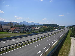
The A1 motorway is 236,1 km long, connecting Šentilj
(at the Austria
n border) and Koper/Capodistria (on the shores of the Adriatic Sea
). It passes several important Slovenian cities, including Maribor
, Celje
and Ljubljana
all the way to the Slovenian Littoral
and Koper, with its important port
.
Construction began in 1970 and the first section was finished in 1972, connecting Vrhnika
and Postojna
. Everyday operation of this initial stretch started on 29 December 1972.
The connection to Koper was finished on 23 November 2004. The second-to-last part, from Trojane
to Blagovica
, was opened on 12 August 2005. It was also the most expensive, having eight viaducts and two tunnels despite being only 11 km long. The final section, the eastern Maribor bypass, opened on 14 August 2009.
on the motorway:
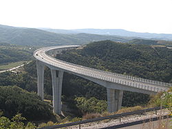
 There are 49 viaduct
s, given in order from Šentilj to Koper:
The Črni Kal Viaduct
is the longest viaduct
in Slovenia
.
Šentilj
Šentilj is a municipality in Slovenia. The seat of the municipality is the town of Šentilj v Slovenskih goricah . This town was an Austria-Slovenia border crossing checkpoint until December 21, 2007, when all immigration and customs checks ended after Slovenia joined the Schengen Area...
(at the Austria
Austria
Austria , officially the Republic of Austria , is a landlocked country of roughly 8.4 million people in Central Europe. It is bordered by the Czech Republic and Germany to the north, Slovakia and Hungary to the east, Slovenia and Italy to the south, and Switzerland and Liechtenstein to the...
n border) and Koper/Capodistria (on the shores of the Adriatic Sea
Adriatic Sea
The Adriatic Sea is a body of water separating the Italian Peninsula from the Balkan peninsula, and the system of the Apennine Mountains from that of the Dinaric Alps and adjacent ranges...
). It passes several important Slovenian cities, including Maribor
Maribor
Maribor is the second largest city in Slovenia with 157,947 inhabitants . Maribor is also the largest and the capital city of Slovenian region Lower Styria and the seat of the Municipality of Maribor....
, Celje
Celje
Celje is a typical Central European town and the third largest town in Slovenia. It is a regional center of Lower Styria and the administrative seat of the Urban Municipality of Celje . The town of Celje is located under Upper Celje Castle at the confluence of the Savinja, Ložnica, and Voglajna...
and Ljubljana
Ljubljana
Ljubljana is the capital of Slovenia and its largest city. It is the centre of the City Municipality of Ljubljana. It is located in the centre of the country in the Ljubljana Basin, and is a mid-sized city of some 270,000 inhabitants...
all the way to the Slovenian Littoral
Slovenian Littoral
The Slovenian Littoral is a historical region of Slovenia. Its name recalls the historical Habsburg crown land of the Austrian Littoral, of which the Slovenian Littoral was a part....
and Koper, with its important port
Port
A port is a location on a coast or shore containing one or more harbors where ships can dock and transfer people or cargo to or from land....
.
Construction began in 1970 and the first section was finished in 1972, connecting Vrhnika
Vrhnika
Vrhnika is a town and a municipality in Slovenia. It is situated on the Ljubljanica River, 21 km from Ljubljana along the A1 motorway.-History:...
and Postojna
Postojna
Postojna is a town and a municipality in the traditional region of Inner Carniola, from Trieste, in southwestern Slovenia. Population 14,581 .-History:...
. Everyday operation of this initial stretch started on 29 December 1972.
The connection to Koper was finished on 23 November 2004. The second-to-last part, from Trojane
Trojane
Trojane , is a settlement in the Municipality of Lukovica in central Slovenia. It lies on a hill near the border of two Slovene regions, Carniola and Styria. Until the freeway was finished in 2005, Trojane was on the main route from Ljubljana to Maribor.The Romans built a road on the route...
to Blagovica
Blagovica
Blagovica is a village in the Lukovica Municipality in the eastern part of the Upper Carniola region of Slovenia.Village Blagovica lies between rivers Radomlja and Zlatenščica and is the local center of the central-eastern part of the Črni graben Valley with an Elementary School, a Post Office, a...
, was opened on 12 August 2005. It was also the most expensive, having eight viaducts and two tunnels despite being only 11 km long. The final section, the eastern Maribor bypass, opened on 14 August 2009.
Interchanges
There are 8 interchangesInterchange (road)
In the field of road transport, an interchange is a road junction that typically uses grade separation, and one or more ramps, to permit traffic on at least one highway to pass through the junction without directly crossing any other traffic stream. It differs from a standard intersection, at which...
on the motorway:
- Dragučova (A5A5 motorway (Slovenia)The A5 motorway is 85,5 km long. It begins at the Dragučova interchange on the A1 motorway north of Maribor and ends at the Hungarian border at Pince, continuing on in Hungary as the M70 motorway...
) - Slivnica (A4A4 motorway (Slovenia)The A4 motorway is a motorway in Slovenia, planned to be 33.7 km long, connecting Maribor and Gruškovje . It also connects the two principal cities of the Podravska region of Slovenia, Maribor and Ptuj...
) - Zadobrova (H3)
- Malence (A2A2 motorway (Slovenia)The A2 motorway is a motorway in Slovenia, around 175 km long, connecting Karavanke Tunnel via the capital city Ljubljana to Obrežje . It connects several larger Slovenian cities, including Kranj, Ljubljana and Novo Mesto, and is part of the Pan-European corridor X.The motorway was completed...
) - Kozarje (A2)
- Razdrto (H4)
- Gabrk (A3)
- Srmin (H5)
Tunnels
The motorway includes 10 tunnels and 2 galleries:- VodoleVodoleVodole is a dispersed settlement in the hills to the northeast of Maribor in northeastern Slovenia. It belongs to the Maribor urban municipality.-External links:*...
(225 m) - MalečnikMalecnikMalečnik is a village on the left bank of the river Drava to the east of Maribor in northeastern Slovenia. It belongs to the Maribor urban municipality....
(185 m), gallery - Golo rebro (788 m)
- PletovarjePletovarjePletovarje is a settlement in the Šentjur municipality in eastern Slovenia. It lies to the east of Dramlje and the Slovenian A1 motorway crosses over the settlement territory. The area is part of the historical Lower Styria region. The municipality is now included in the Savinja statistical...
(745 m) - Ločica (810 m)
- Jasovnik (1,633 m)
- TrojaneTrojaneTrojane , is a settlement in the Municipality of Lukovica in central Slovenia. It lies on a hill near the border of two Slovene regions, Carniola and Styria. Until the freeway was finished in 2005, Trojane was on the main route from Ljubljana to Maribor.The Romans built a road on the route...
(2,931 m) - PodmiljPodmiljPodmilj is a dispersed settlement east of Blagovica in the Lukovica Municipality in the eastern part of the Upper Carniola region of Slovenia.-External links:*...
(622 m) - Strmec (200 m), gallery
- GolovecGolovecThe Golovec District or simply Golovec is a city district of Ljubljana, the capital of Slovenia. It encompasses Golovec Hill, which dates back to the Carboniferous period and consists of clastic rock ....
(595 m) - Štampetov most (15 m)
- KastelecKastelecKastelec is a settlement in the Koper Municipality in the Littoral region of Slovenia.The local church is dedicated to The Exaltation of the Holy Cross and belongs to the Klanec Parish.-External links:*...
(2,292 m) - DekaniDekaniDekani is a settlement in the Municipality pf Koper in the Littoral region of Slovenia.The local church is dedicated to the Assumption of Mary and was originally built in 1229 and remodeled at the end of the 15th century.-External links:*...
(2,190 m)
Viaducts
Viaduct
A viaduct is a bridge composed of several small spans. The term viaduct is derived from the Latin via for road and ducere to lead something. However, the Ancient Romans did not use that term per se; it is a modern derivation from an analogy with aqueduct. Like the Roman aqueducts, many early...
s, given in order from Šentilj to Koper:
|
|
Kozina Kozina is a settlement in the municipality of Hrpelje-Kozina in the Littoral region of Slovenia, close to the border with Italy.The village developed only after the railway was established; in 1825 there were only three houses in Kozina. It became an important center for teamsters, with twelve inns... - Koper (75 m) Crni Kal Viaduct The Črni Kal Viaduct is the longest and highest viaduct in Slovenia. It is located on the A1 motorway above the Osp Valley near the village of Gabrovica, about 20 km east of Koper. Its name means "Black Dale" in Slovene, after the depression it crosses.... (1,065 m) |
The Črni Kal Viaduct
Crni Kal Viaduct
The Črni Kal Viaduct is the longest and highest viaduct in Slovenia. It is located on the A1 motorway above the Osp Valley near the village of Gabrovica, about 20 km east of Koper. Its name means "Black Dale" in Slovene, after the depression it crosses....
is the longest viaduct
Viaduct
A viaduct is a bridge composed of several small spans. The term viaduct is derived from the Latin via for road and ducere to lead something. However, the Ancient Romans did not use that term per se; it is a modern derivation from an analogy with aqueduct. Like the Roman aqueducts, many early...
in Slovenia
Slovenia
Slovenia , officially the Republic of Slovenia , is a country in Central and Southeastern Europe touching the Alps and bordering the Mediterranean. Slovenia borders Italy to the west, Croatia to the south and east, Hungary to the northeast, and Austria to the north, and also has a small portion of...
.