
2007 Kent earthquake
Encyclopedia

Earthquake
An earthquake is the result of a sudden release of energy in the Earth's crust that creates seismic waves. The seismicity, seismism or seismic activity of an area refers to the frequency, type and size of earthquakes experienced over a period of time...
that registered 4.3 on the Richter scale
Richter magnitude scale
The expression Richter magnitude scale refers to a number of ways to assign a single number to quantify the energy contained in an earthquake....
and struck south east Kent
Kent
Kent is a county in southeast England, and is one of the home counties. It borders East Sussex, Surrey and Greater London and has a defined boundary with Essex in the middle of the Thames Estuary. The ceremonial county boundaries of Kent include the shire county of Kent and the unitary borough of...
, England on 28 April 2007 at 07:18:12 UTC (08:18:12 local time), at a shallow depth of 5.3 km.
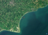
The worst affected area was the town of Folkestone
Folkestone
Folkestone is the principal town in the Shepway District of Kent, England. Its original site was in a valley in the sea cliffs and it developed through fishing and its closeness to the Continent as a landing place and trading port. The coming of the railways, the building of a ferry port, and its...
, although the towns of Deal
Deal, Kent
Deal is a town in Kent England. It lies on the English Channel eight miles north-east of Dover and eight miles south of Ramsgate. It is a former fishing, mining and garrison town...
, Dover
Dover
Dover is a town and major ferry port in the home county of Kent, in South East England. It faces France across the narrowest part of the English Channel, and lies south-east of Canterbury; east of Kent's administrative capital Maidstone; and north-east along the coastline from Dungeness and Hastings...
and Ashford
Ashford, Kent
Ashford is a town in the borough of Ashford in Kent, England. In 2005 it was voted the fourth best place to live in the United Kingdom. It lies on the Great Stour river, the M20 motorway, and the South Eastern Main Line and High Speed 1 railways. Its agricultural market is one of the most...
were also affected. The tremors could be felt across much of Kent and south east England including as far as East Sussex
East Sussex
East Sussex is a county in South East England. It is bordered by the counties of Kent, Surrey and West Sussex, and to the south by the English Channel.-History:...
, Essex
Essex
Essex is a ceremonial and non-metropolitan county in the East region of England, and one of the home counties. It is located to the northeast of Greater London. It borders with Cambridgeshire and Suffolk to the north, Hertfordshire to the west, Kent to the South and London to the south west...
and Suffolk
Suffolk
Suffolk is a non-metropolitan county of historic origin in East Anglia, England. It has borders with Norfolk to the north, Cambridgeshire to the west and Essex to the south. The North Sea lies to the east...
as well as on the other side of the English Channel
English Channel
The English Channel , often referred to simply as the Channel, is an arm of the Atlantic Ocean that separates southern England from northern France, and joins the North Sea to the Atlantic. It is about long and varies in width from at its widest to in the Strait of Dover...
at Calais
Calais
Calais is a town in Northern France in the department of Pas-de-Calais, of which it is a sub-prefecture. Although Calais is by far the largest city in Pas-de-Calais, the department's capital is its third-largest city of Arras....
and Brussels
Brussels
Brussels , officially the Brussels Region or Brussels-Capital Region , is the capital of Belgium and the de facto capital of the European Union...
.
Location
The British Geological SurveyBritish Geological Survey
The British Geological Survey is a partly publicly funded body which aims to advance geoscientific knowledge of the United Kingdom landmass and its continental shelf by means of systematic surveying, monitoring and research. The BGS headquarters are in Keyworth, Nottinghamshire, but other centres...
stated that the epicentre of the earthquake was less than 1 km north of Folkestone at 51.10°N, 1.17°E. The United States Geological Survey
United States Geological Survey
The United States Geological Survey is a scientific agency of the United States government. The scientists of the USGS study the landscape of the United States, its natural resources, and the natural hazards that threaten it. The organization has four major science disciplines, concerning biology,...
indicated that the location of the earthquake was at 51.085°N, 1.009°E suggesting a position approximately 5 km north west of Hythe
Hythe, Kent
Hythe , is a small coastal market town on the edge of Romney Marsh, in the District of Shepway on the south coast of Kent. The word Hythe or Hithe is an Old English word meaning Haven or Landing Place....
.
Impact
The earthquake's shallow depth and proximity to Folkestone resulted in structural damage in the town, and one woman suffered a minor head and neck injury. Following the earthquake, a total 474 properties were reported as damaged with 73 properties too badly damaged for people to return to, 94 seriously damaged, and 307 suffering from minor structural damage. Harvey Grammar School situated in Cheriton Road, Folkestone was closed on 30 April due to "significant structural damage".Several thousand homes were left without power for several hours and there were reports of a "smell of gas" in Folkestone. The Port of Dover
Port of Dover
The Port of Dover is the cross-channel port situated in Dover, south-east England. It is the nearest English port to France, at just away, and one of Europe's largest passenger ports, with 14 million travellers, 2.1 million lorries, 2.8 million cars and motorcycles and 86,000 coaches passing...
, the channel tunnel
Channel Tunnel
The Channel Tunnel is a undersea rail tunnel linking Folkestone, Kent in the United Kingdom with Coquelles, Pas-de-Calais near Calais in northern France beneath the English Channel at the Strait of Dover. At its lowest point, it is deep...
and travel links were unaffected although authorities asked people heading towards Dover to use the A2
A2 road (Great Britain)
The A2 is a major road in southern England, connecting London with the English Channel port of Dover in Kent. This route has always been of importance as a connection between the British capital of London and sea trade routes to Continental Europe...
. It is also possible that the earthquake caused a 300 metre (948 ft) crack in a cliff at Barton-on-Sea
New Milton
New Milton is a market town in south west Hampshire, England. The town has a high street and holds a market every Wednesday. Situated on the edge of the New Forest, the town is about 6 miles west of Lymington town centre and 12 miles east of Bournemouth town centre.-History:New Milton dates back...
creating fears of a landslide. However, this could also be purely coincidental.
EDF Energy had restored electricity supplies that had been cut by the earthquake by the same afternoon. The Salvation Army
Salvation Army
The Salvation Army is a Protestant Christian church known for its thrift stores and charity work. It is an international movement that currently works in over a hundred countries....
Church in Folkestone provided refuge for approximately 100 people on 28 April whose homes had been damaged by the earthquake.
Magnitude
The British Geological Survey gave the earthquake a reading of 4.3 on the Richter scale, while the USGS and the European-Mediterranean Seismological Centre estimated that the earthquake had a body wave magnitudeBody wave magnitude
Body wave magnitude is a way of determining the size of an earthquake, using the amplitude of the initial P-wave to calculate the magnitude. The P-wave is a type of body wave that is capable of traveling through the earth at a velocity of around 5 to 8 km/s, and is the first wave from an...
of 4.6 and 4.7 respectively.
It was the largest British earthquake since the 2002 Dudley earthquake
2002 Dudley earthquake
The 2002 Dudley earthquake was an earthquake registering 4.7 on the Richter scale that struck the Midlands of England, on 22 September 2002 23:53 UTC and lasted approximately 20 seconds....
and the strongest in the Dover Straits since a magnitude 4.4 earthquake in 1950. The strongest recorded British earthquake was the 1931 Dogger Bank earthquake
1931 Dogger Bank earthquake
The Dogger Bank earthquake of 1931 was the strongest earthquake recorded in the United Kingdom since measurements began. It measured 6.1 on the Richter Scale....
which measured 6.1 on the Richter scale.
Less than two years later on 3 March 2009 at 14.35 UTC, Folkestone was shaken by a smaller magnitude 3.0 quake, located in the same area.
See also
- List of earthquakes in the United Kingdom
- Geology of the United Kingdom
- Dover Straits earthquake of 1580Dover Straits earthquake of 1580Though severe earthquakes in the north of France and Britain are rare, the Dover Straits earthquake of 6 April 1580 appears to have been one of the largest in the recorded history of England, Flanders or northern France...