

2006 European floods
Encyclopedia
_3.jpg)
Danube
The Danube is a river in the Central Europe and the Europe's second longest river after the Volga. It is classified as an international waterway....
, swelled due to heavy rain and melting snow and rose to record levels. These are the longest rivers in Central Europe
Central Europe
Central Europe or alternatively Middle Europe is a region of the European continent lying between the variously defined areas of Eastern and Western Europe...
.
Southeastern Europe
High DanubeDanube
The Danube is a river in the Central Europe and the Europe's second longest river after the Volga. It is classified as an international waterway....
levels caused significant flooding in parts of Serbia
Serbia
Serbia , officially the Republic of Serbia , is a landlocked country located at the crossroads of Central and Southeast Europe, covering the southern part of the Carpathian basin and the central part of the Balkans...
, Bulgaria
Bulgaria
Bulgaria , officially the Republic of Bulgaria , is a parliamentary democracy within a unitary constitutional republic in Southeast Europe. The country borders Romania to the north, Serbia and Macedonia to the west, Greece and Turkey to the south, as well as the Black Sea to the east...
and Romania
Romania
Romania is a country located at the crossroads of Central and Southeastern Europe, on the Lower Danube, within and outside the Carpathian arch, bordering on the Black Sea...
, with damage to property and infrastructure in localities near the shores of the river. The effects of high water across Southeastern Europe were blamed on the poor levee
Levee
A levee, levée, dike , embankment, floodbank or stopbank is an elongated naturally occurring ridge or artificially constructed fill or wall, which regulates water levels...
systems in the affected countries.
Bulgaria
Vidin
Vidin is a port town on the southern bank of the Danube in northwestern Bulgaria. It is close to the borders with Serbia and Romania, and is also the administrative centre of Vidin Province, as well as of the Metropolitan of Vidin...
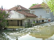
an industrial district was flooded and over 300 people were evacuated to a tent city about 20 kilometers from the town. In Lom, Bulgaria 25 houses, a hotel, the port (which is the second biggest Bulgarian port on the River Danube), and the Danube Park were flooded. Boruna quarter in the north-western part of the city has declared a state of emergency. Of the 30.000 people who live in Lom, 6.000 people are in danger due to the flooding. The two schools are prepared to accommodate any people if found necessary. A few blocks along the water's edge in the city of Nikopol
Nikopol, Bulgaria
Nikopol is a town in northern Bulgaria, the administrative center of Nikopol municipality, part of Pleven Province, on the right bank of the Danube river, 4 km downstream from the mouth of the Osam river. It spreads at the foot of steep chalk cliffs along the Danube and up a narrow valley...
were flooded. 60 people were evacuated and 57 buildings have been flooded so far as well as the main road from Nikopol west towards Pleven
Pleven
Pleven is the seventh most populous city in Bulgaria. Located in the northern part of the country, it is the administrative centre of Pleven Province, as well as of the subordinate Pleven municipality...
. In Rousse
Rousse
Ruse is the fifth-largest city in Bulgaria. Ruse is situated in the northeastern part of the country, on the right bank of the Danube, opposite the Romanian city of Giurgiu, from the capital Sofia and from the Bulgarian Black Sea Coast...
the Danube reached 9 meters, beating the previous record at 8,88 from 1970. In total at least 400 buildings on Bulgaria's northern border have been flooded and several have been completely destroyed.
Romania
The 2006 European floods were one of the most devastating natural disaster from the History of Romania. Although there were no human victims, the estimated damage is thought to surpass the floods of 19701970 floods in Romania
The 1970 floods in Romania, brought on by river swelling caused by torrential rains, high winds and a heat wave that melted snow in the Carpathian Mountains, were the worst in modern Romanian history in loss of life, and caused the most damage up to the 2006 floods: at least $500 million; perhaps...
.
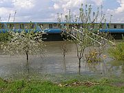
By April 16 over 848 houses were reportedly flooded, with 221 destroyed. The height of the Danube at the beginning of the flood was still below the record level registered in 1895. Romanian officials ordered the controlled flooding of thousands of hectares of unused agricultural spaces to prevent further damage in cities across Romania.
On April 16, in the localities of Rast and Negoi
Negoi, Dolj
Negoi is a commune in Dolj County, Romania with a population of 4,286 people. It is composed of a single village, Negoi. It also included Catane and Catanele Noi villages until 2004, when they were split off to form Catane Commune....
, Dolj County
Dolj County
Dolj -Jiu, "lower Jiu", toward Gorj ) is a county of Romania, in Oltenia, with the capital city at Craiova .- Demographics :In 2002, it had a population of 734,231 and a population density of 99/km²....
, more than 800 residents were evacuated, as a dam collapsed due to the rising waters of the Danube. Hundreds of houses were flooded and more than 100 of them collapsed.
By April 22, the number of people evacuated from the locality reached 4,000. In the port city of Călăraşi
Calarasi
Călăraşi , the capital of Călăraşi County and Sud-Muntenia Region in the Wallachia region, is situated in south-east Romania, on the bank of Danube's Borcea branch, at about 12 kilometers from the Bulgarian border and 125 kilometers from Bucharest....
, a recently-opened hotel was flooded on Monday, April 17, causing significant damage to the building and leading to the evacuation of tens of tourists.
By this date, the floods had swamped 730 square kilometres of land, 400 km of roads and destroyed 20 bridges, while also causing agricultural damage of 4.6 million lei
Romanian leu
The leu is the currency of Romania. It is subdivided into 100 bani . The name of the currency means "lion". On 1 July 2005, Romania underwent a currency reform, switching from the previous leu to a new leu . 1 RON is equal to 10,000 ROL...
(US$1.5 million). Additionally, five of Romania's nine Danube ports were closed during the flooding period. However, Romanian authorities said on April 22 that the worst of the flooding had passed. Elena Anghel, hydrologist at Romania's National Hydrology Institute stated that, "The forecasts are optimistic. The river will probably remain stable for another two days and then start to fall."
However, by April 28, key levees along the Danube began collapsing in counties of Dolj
Dolj County
Dolj -Jiu, "lower Jiu", toward Gorj ) is a county of Romania, in Oltenia, with the capital city at Craiova .- Demographics :In 2002, it had a population of 734,231 and a population density of 99/km²....
, Călăraşi
Calarasi County
Călărași is a county of Romania, in Muntenia, with the county seat at Călărași.-Demographics:In 2002, it had a population of 324,617 and a population density of 64/km².*Romanians – 95%*Roma and others.-List of cities by population:...
, Constanţa
Constanta County
Constanța is the name of a county in the Dobruja region of Romania. Its capital city is also named Constanța.-Demographics:In 2002, it had a population of 715,151 and the population density was 101/km². The degree of urbanization is much higher than the Romanian average. In recent years the...
, Tulcea
Tulcea County
Tulcea is a county of Romania, in the historical region Dobruja, with the capital city at Tulcea.-Demographics:In 2002, Tulcea County had a population of 256,492...
and Galaţi
Galati County
Galaţi is a county of Romania, in Moldavia region, with the capital city at Galaţi.-History:Historically Galaţi is part of Moldavia...
, after several weeks of pressure. The authorities carried out further evacuations in these regions, the number of evacuated people rising to 16,000. By this date, over 300 houses were completely destroyed with more than 150 villages and towns being directly affected by the floods .
As of April 28 the authorities were still estimating the total damage done by the floods, but an accurate estimations are expected to be released no sooner than mid-May, 2006
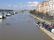
Serbia
State of emergency
A state of emergency is a governmental declaration that may suspend some normal functions of the executive, legislative and judicial powers, alert citizens to change their normal behaviours, or order government agencies to implement emergency preparedness plans. It can also be used as a rationale...
was declared in 10 regions of Serbia. The areas around Serbia's second largest city Novi Sad
Novi Sad
Novi Sad is the capital of the northern Serbian province of Vojvodina, and the administrative centre of the South Bačka District. The city is located in the southern part of Pannonian Plain on the Danube river....
were particularly vulnerable. A dozen cities were damaged and hundreds of people were evacuated. Near Veliko Gradište
Veliko Gradište
Veliko Gradište is a town and municipality located in Serbia, in north-east Serbia , on the right bank of the Danube river and left bank of the Pek river...
, the Danube reached heights as high as 9.65 meters (over 30 ft). Many people left the regions because water could not be purified.
Other countries
Floods were also reported in the Republic of MacedoniaRepublic of Macedonia
Macedonia , officially the Republic of Macedonia , is a country located in the central Balkan peninsula in Southeast Europe. It is one of the successor states of the former Yugoslavia, from which it declared independence in 1991...
, where several villages were flooded in Macedonia's Pelagonija Valley.
Germany and Czech Republic
The Elbe River also rose 13 centimeters higher than in 2002 in some areas, creating 150-year-record-highs. In GermanyGermany
Germany , officially the Federal Republic of Germany , is a federal parliamentary republic in Europe. The country consists of 16 states while the capital and largest city is Berlin. Germany covers an area of 357,021 km2 and has a largely temperate seasonal climate...
, the medieval town of Hitzacker
Hitzacker
Hitzacker is a town in the Lüchow-Dannenberg district of Lower Saxony, Germany. It is situated on the river Elbe, approx. 8 km north of Dannenberg, and 45 km east of Lüneburg. The 2007 population of Hitzacker was 4,982, and its postal code is 29456. The mayor is Karl Guhl...
had water levels of 7.63 meters, destroying many buildings and causing considerable damage to other private property. Also affected was the town of Lauenburg.
The German federal state of Saxony
Saxony
The Free State of Saxony is a landlocked state of Germany, contingent with Brandenburg, Saxony Anhalt, Thuringia, Bavaria, the Czech Republic and Poland. It is the tenth-largest German state in area, with of Germany's sixteen states....
and the Czech Republic
Czech Republic
The Czech Republic is a landlocked country in Central Europe. The country is bordered by Poland to the northeast, Slovakia to the east, Austria to the south, and Germany to the west and northwest....
were not as affected, because in the four years after the record floodings of 2002, the two partners built a stronger levee system along the Elbe.
On April 17, all states of emergencies in all counties of the German federal states of Lower Saxony
Lower Saxony
Lower Saxony is a German state situated in north-western Germany and is second in area and fourth in population among the sixteen states of Germany...
, Saxony-Anhalt
Saxony-Anhalt
Saxony-Anhalt is a landlocked state of Germany. Its capital is Magdeburg and it is surrounded by the German states of Lower Saxony, Brandenburg, Saxony, and Thuringia.Saxony-Anhalt covers an area of...
and Brandenburg
Brandenburg
Brandenburg is one of the sixteen federal-states of Germany. It lies in the east of the country and is one of the new federal states that were re-created in 1990 upon the reunification of the former West Germany and East Germany. The capital is Potsdam...
were rescinded.
Hungary
Budapest
Budapest is the capital of Hungary. As the largest city of Hungary, it is the country's principal political, cultural, commercial, industrial, and transportation centre. In 2011, Budapest had 1,733,685 inhabitants, down from its 1989 peak of 2,113,645 due to suburbanization. The Budapest Commuter...
, Hungary
Hungary
Hungary , officially the Republic of Hungary , is a landlocked country in Central Europe. It is situated in the Carpathian Basin and is bordered by Slovakia to the north, Ukraine and Romania to the east, Serbia and Croatia to the south, Slovenia to the southwest and Austria to the west. The...
, higher than the previous record of 848 cm in 2002. During the floods, approximately 11,000 buildings were in danger of flood damage, 32,000 people were threatened by the water, and 1.72 square kilometres (475 acres) of land were actually under water. Officials also placed most of the area near the Danube under a Level 3 Alert (on a 3-level scale). The flood was so severe that it threatened to spill into the underground in Budapest, through the Batthyány tér station — this, however, did not occur. The underground train stations Batthyány tér and Margit híd (HÉV
HÉV
Budapest HÉV is a system of four commuter rail and rapid transit lines in and around Budapest, Hungary. The HÉV lines were constructed as branch lines of the Hungarian State Railways...
) were closed out of precaution.
The timing of the flood, incidentally, coincided with the Hungarian general elections
Hungarian parliamentary election, 2006
The schedule of the 2006 Hungarian parliamentary elections, as announced by president László Sólyom was as follows:* first round on April 9, 2006* second round on April 23, 2006...
.
Causes
Many dikes and levees breached because of a poor construction by local and national officials and of an unusual long and hard winter in Central Europe. The snowfall lasted well into April and many areas were frozen, so frost emerged, soaking the earth full of water.Humanitarian aid
The Red Cross sent humanitarian aid in the form of blankets and mattresses to affected areas.External links
- Balkans in race to stem flooding BBC NewsBBC NewsBBC News is the department of the British Broadcasting Corporation responsible for the gathering and broadcasting of news and current affairs. The department is the world's largest broadcast news organisation and generates about 120 hours of radio and television output each day, as well as online...
- Massive German floods monitored from space
- Flood claim first victim in Austria
- 32,000 people in danger of floods