
2004 Christmas Eve Snowstorm
Encyclopedia
The 2004 Christmas Eve Snowstorm was a rare weather
event that took place in Louisiana
and Texas in the United States on December 24, 2004 before the storm moved northeast to affect the coastal sections of the Mid-Atlantic states
and New England
in the succeeding few days. This was a different storm
from the historic event that struck the Midwest and southern Canada around December 23 from another cyclone which preceded this storm. The event involved a thin band of snow
fall with unusually cold temperatures for the middle Texas coast, and caused dozens of varied weather records to be shattered. It was the most significant snow for the Texas Gulf Coast, and deep South Texas, since February 1895.
) to lead to snow along the Gulf of Mexico
coastline of the United States.
on December 24 and December 25 due to a shortwave aloft, and moved eastward through the western Gulf of Mexico, bringing banded snowfall to the middle Texas coast. The extratropical cyclone
moved east, then northeast, tracking across the northern peninsula of Florida early on December 26 before moving about 100 miles (200 km) offshore the Southeast, paralleling the coast. Continuing to deepen, the developing storm moved about 200 miles (300 km) offshore the Mid-Atlantic states, New England
, and Atlantic Canada
on December 27 before moving out to sea.
, but some snow, albeit less deep, fell across southwestern and southeastern Louisiana
. Any snowfall in these areas is extremely unusual, perhaps occurring once every twenty years, and these events are usually airborne flurries which melt on contact with the ground. The fact that in many places the snow stuck to the ground and accumulated to an appreciable depth was nearly unprecedented. In Brownsville, Texas
, snow fell to a depth of 1.5 inches (3.8 cm), the first measurable snowfall at the city in 105 years, since the Great Blizzard of 1899
.
 The fact that the snow accumulated overnight on Christmas Eve
led to a White Christmas
the next morning, something completely foreign to the region. The city of Houston recorded the first White Christmas in its history. Across all of southern Texas and in southwestern Louisiana, snow fell in places where it had not for anywhere from 15 to 120 years. Near the coast, in Corpus Christi, Texas
, 5.2 inches (13.2 cm) of snow fell, more snow than in all previous recorded years combined. This was also the case in Victoria, Texas
, where a significant 13 inches (33 cm) fell. In addition to the unusual occurrence of snow inland, moderate to heavy snow was also reported over the open waters of the Gulf of Mexico
. This is the first significant snow fall in Houston since February 12, 1960 when a snowstorm hit central and south Texas with eight to 10 inches of snow.
 Some snow totals:
and Aiken
.
.
reported over a foot of snow, with the highest amount of 14 inches (35.6 cm) reported at Quinby
and Tabb
. Frontogenesis (strengthening temperature gradient) within the comma head of the extratropical cyclone
between the 500 hPa and 700 hPa layers (or 10-20 kft) contributed to the banded snow seen across this region. It led to the snowiest December across the Norfolk
area since 1958.
, with the highest amount of 4.5 inches (11.4 cm) measured at Shelltown
.
.
.
.
. Brewster
measured 18 inches (45.7 cm) during the event.
.
.
. The highest amount reported was from Whiting
where 13 inches (33 cm) was measured.
Weather
Weather is the state of the atmosphere, to the degree that it is hot or cold, wet or dry, calm or stormy, clear or cloudy. Most weather phenomena occur in the troposphere, just below the stratosphere. Weather refers, generally, to day-to-day temperature and precipitation activity, whereas climate...
event that took place in Louisiana
Louisiana
Louisiana is a state located in the southern region of the United States of America. Its capital is Baton Rouge and largest city is New Orleans. Louisiana is the only state in the U.S. with political subdivisions termed parishes, which are local governments equivalent to counties...
and Texas in the United States on December 24, 2004 before the storm moved northeast to affect the coastal sections of the Mid-Atlantic states
Mid-Atlantic States
The Mid-Atlantic states, also called middle Atlantic states or simply the mid Atlantic, form a region of the United States generally located between New England and the South...
and New England
New England
New England is a region in the northeastern corner of the United States consisting of the six states of Maine, New Hampshire, Vermont, Massachusetts, Rhode Island, and Connecticut...
in the succeeding few days. This was a different storm
Pre-Christmas 2004 snowstorm
An historic snowstorm struck the Ohio Valley of the United States, as well as Ontario in Canada, on December 22 and December 23 and is not the same storm that led to snow in Texas on Christmas Eve. It lasted roughly 30 hours, and brought snowfall amounts up to 37 inches to portions of...
from the historic event that struck the Midwest and southern Canada around December 23 from another cyclone which preceded this storm. The event involved a thin band of snow
Snow
Snow is a form of precipitation within the Earth's atmosphere in the form of crystalline water ice, consisting of a multitude of snowflakes that fall from clouds. Since snow is composed of small ice particles, it is a granular material. It has an open and therefore soft structure, unless packed by...
fall with unusually cold temperatures for the middle Texas coast, and caused dozens of varied weather records to be shattered. It was the most significant snow for the Texas Gulf Coast, and deep South Texas, since February 1895.
Anticipation of the event
There had been indications for up to a week before the event that a frontal wave in the Gulf of Mexico was expected to track far enough to the south (along roughly the 26th parallel26th parallel north
The 26th parallel north is a circle of latitude that is 26 degrees north of the Earth's equatorial plane. It crosses Africa, Asia, the Indian Ocean, the Pacific Ocean, North America and the Atlantic Ocean....
) to lead to snow along the Gulf of Mexico
Gulf of Mexico
The Gulf of Mexico is a partially landlocked ocean basin largely surrounded by the North American continent and the island of Cuba. It is bounded on the northeast, north and northwest by the Gulf Coast of the United States, on the southwest and south by Mexico, and on the southeast by Cuba. In...
coastline of the United States.
Synoptic history
A surface cyclone formed in the western Gulf of MexicoGulf of Mexico
The Gulf of Mexico is a partially landlocked ocean basin largely surrounded by the North American continent and the island of Cuba. It is bounded on the northeast, north and northwest by the Gulf Coast of the United States, on the southwest and south by Mexico, and on the southeast by Cuba. In...
on December 24 and December 25 due to a shortwave aloft, and moved eastward through the western Gulf of Mexico, bringing banded snowfall to the middle Texas coast. The extratropical cyclone
Extratropical cyclone
Extratropical cyclones, sometimes called mid-latitude cyclones or wave cyclones, are a group of cyclones defined as synoptic scale low pressure weather systems that occur in the middle latitudes of the Earth having neither tropical nor polar characteristics, and are connected with fronts and...
moved east, then northeast, tracking across the northern peninsula of Florida early on December 26 before moving about 100 miles (200 km) offshore the Southeast, paralleling the coast. Continuing to deepen, the developing storm moved about 200 miles (300 km) offshore the Mid-Atlantic states, New England
New England
New England is a region in the northeastern corner of the United States consisting of the six states of Maine, New Hampshire, Vermont, Massachusetts, Rhode Island, and Connecticut...
, and Atlantic Canada
Atlantic Canada
Atlantic Canada is the region of Canada comprising the four provinces located on the Atlantic coast, excluding Quebec: the three Maritime provinces – New Brunswick, Prince Edward Island, and Nova Scotia – and Newfoundland and Labrador...
on December 27 before moving out to sea.
Texas and Louisiana
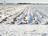
The most noticeable, and unusual, event associated with the storm was the snowfall it produced. Much of the snow fell in southern Texas, along the coast of the Gulf of MexicoGulf of Mexico
The Gulf of Mexico is a partially landlocked ocean basin largely surrounded by the North American continent and the island of Cuba. It is bounded on the northeast, north and northwest by the Gulf Coast of the United States, on the southwest and south by Mexico, and on the southeast by Cuba. In...
, but some snow, albeit less deep, fell across southwestern and southeastern Louisiana
Louisiana
Louisiana is a state located in the southern region of the United States of America. Its capital is Baton Rouge and largest city is New Orleans. Louisiana is the only state in the U.S. with political subdivisions termed parishes, which are local governments equivalent to counties...
. Any snowfall in these areas is extremely unusual, perhaps occurring once every twenty years, and these events are usually airborne flurries which melt on contact with the ground. The fact that in many places the snow stuck to the ground and accumulated to an appreciable depth was nearly unprecedented. In Brownsville, Texas
Brownsville, Texas
Brownsville is a city in the southernmost tip of the state of Texas, in the United States. It is located on the northern bank of the Rio Grande, directly north and across the border from Matamoros, Tamaulipas, Mexico. Brownsville is the 16th largest city in the state of Texas with a population of...
, snow fell to a depth of 1.5 inches (3.8 cm), the first measurable snowfall at the city in 105 years, since the Great Blizzard of 1899
Great Blizzard of 1899
The Great Blizzard of 1899 was an unprecedented winter weather event that affected the southern United States. What made it historic was both the severity of winter weather and the extent of the U.S. it affected, especially in the South. The first reports indicated record-high barometric pressure...
.
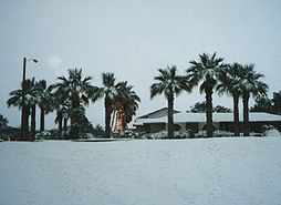
Christmas Eve
Christmas Eve refers to the evening or entire day preceding Christmas Day, a widely celebrated festival commemorating the birth of Jesus of Nazareth that takes place on December 25...
led to a White Christmas
White Christmas
A white Christmas refers to the presence of snow on Christmas Day. This phenomenon is most common in the northern countries of the Northern Hemisphere...
the next morning, something completely foreign to the region. The city of Houston recorded the first White Christmas in its history. Across all of southern Texas and in southwestern Louisiana, snow fell in places where it had not for anywhere from 15 to 120 years. Near the coast, in Corpus Christi, Texas
Corpus Christi, Texas
Corpus Christi is a coastal city in the South Texas region of the U.S. state of Texas. The county seat of Nueces County, it also extends into Aransas, Kleberg, and San Patricio counties. The MSA population in 2008 was 416,376. The population was 305,215 at the 2010 census making it the...
, 5.2 inches (13.2 cm) of snow fell, more snow than in all previous recorded years combined. This was also the case in Victoria, Texas
Victoria, Texas
Victoria is a city in and the seat of Victoria County, Texas, United States. The population was 60,603 at the 2000 census. The three counties of the Victoria Metropolitan Statistical Area had a population of 111,163 at the 2000 census,...
, where a significant 13 inches (33 cm) fell. In addition to the unusual occurrence of snow inland, moderate to heavy snow was also reported over the open waters of the Gulf of Mexico
Gulf of Mexico
The Gulf of Mexico is a partially landlocked ocean basin largely surrounded by the North American continent and the island of Cuba. It is bounded on the northeast, north and northwest by the Gulf Coast of the United States, on the southwest and south by Mexico, and on the southeast by Cuba. In...
. This is the first significant snow fall in Houston since February 12, 1960 when a snowstorm hit central and south Texas with eight to 10 inches of snow.
- Alice, TexasAlice, TexasAt the 2000 census, there were 19,010 people, 6,400 households and 4,915 families residing in the city. The population density was 1,597.4 per square mile . There were 6,998 housing units at an average density of 588.0 per square mile...
: 12 inches (30.48 cm) - Brownsville, TexasBrownsville, TexasBrownsville is a city in the southernmost tip of the state of Texas, in the United States. It is located on the northern bank of the Rio Grande, directly north and across the border from Matamoros, Tamaulipas, Mexico. Brownsville is the 16th largest city in the state of Texas with a population of...
: 1.5 inches (3.8 cm) - Corpus Christi, TexasCorpus Christi, TexasCorpus Christi is a coastal city in the South Texas region of the U.S. state of Texas. The county seat of Nueces County, it also extends into Aransas, Kleberg, and San Patricio counties. The MSA population in 2008 was 416,376. The population was 305,215 at the 2010 census making it the...
: 5.2 inches (13.2 cm) - Laredo, TexasLaredo, TexasLaredo is the county seat of Webb County, Texas, United States, located on the north bank of the Rio Grande in South Texas, across from Nuevo Laredo, Tamaulipas, Mexico. According to the 2010 census, the city population was 236,091 making it the 3rd largest on the United States-Mexican border,...
: 2.0 inches (5.07 cm) - El Campo, TexasEl Campo, TexasEl Campo is a city in Wharton County, Texas, United States. The population was 10,945 at the 2000 census, making it the largest city in Wharton County.-Geography:...
: 11.0 inches (27.9 cm) - Houston, Texas: 1.0 inches (2.5 cm)
- Kingsville, TexasKingsville, TexasAs of the census of 2000, there were 25,575 people, 8,943 households, and 6,134 families residing in the city. The population density was 1,848.8 people per square mile . There were 10,427 housing units at an average density of 753.8 per square mile...
: 6.0 inches (15.24 cm) - Lake Charles, LouisianaLake Charles, LouisianaLake Charles is the fifth-largest incorporated city in the U.S. state of Louisiana, located on Lake Charles, Prien Lake, and the Calcasieu River. Located in Calcasieu Parish, a major cultural, industrial, and educational center in the southwest region of the state, and one of the most important in...
: 1.2 inches (3.1 cm) - Mathis, TexasMathis, TexasMathis is a city in San Patricio County, Texas, United States. The population was 5,034 at the 2000 census.In 1887 when the San Antonio and Aransas Pass Railroad was laying tracks across San Patricio County, Thomas H. Mathis got naming rights when he donated for a townsite and school. Mathis could...
: 11 inches (27.9 cm) - McAllen, TexasMcAllen, TexasMcAllen is the largest city in Hidalgo County, Texas, United States. It is located at the southern tip of Texas in an area known as the Rio Grande Valley and is part of the . Its southern boundary is located about five miles from the U.S.–Mexico border and the Mexican city of Reynosa, the Rio...
: 4.0 inches (10.16 cm) - New Orleans, Louisiana: 0.7 inches (1.8 cm)
- Sandia, TexasSandia, TexasSandia is a census-designated place in Jim Wells County, Texas, United States. The population was 431 at the 2000 census.-History:Sandia was in the Casa Blanca land grant, issued to Juan José de la Garza Montemayor by Spain on April 2, 1807. The Montemayor family occupied the land until 1852. In...
: 12 inches (30.48 cm) - Victoria, TexasVictoria, TexasVictoria is a city in and the seat of Victoria County, Texas, United States. The population was 60,603 at the 2000 census. The three counties of the Victoria Metropolitan Statistical Area had a population of 111,163 at the 2000 census,...
: 13.0 inches (33.0 cm) - Beeville, TexasBeeville, TexasBeeville is a city in Bee County, Texas, United States. The population was 13,129 at the 2000 census. It is the county seat of Bee County...
: 10.0 inches (25.4 cm)
Georgia and South Carolina
As the cyclone tracked through Florida offshore the Southeast, up to an inch of freezing rain and sleet fell at AugustaAugusta, Georgia
Augusta is a consolidated city in the U.S. state of Georgia, located along the Savannah River. As of the 2010 census, the Augusta–Richmond County population was 195,844 not counting the unconsolidated cities of Hephzibah and Blythe.Augusta is the principal city of the Augusta-Richmond County...
and Aiken
Aiken, South Carolina
Aiken is a city in and the county seat of Aiken County, South Carolina, United States. With Augusta, Georgia, it is one of the two largest cities of the Central Savannah River Area. It is part of the Augusta-Richmond County Metropolitan Statistical Area. Aiken is home to the University of South...
.
North Carolina
Several inches of snow fell across portions of the state, with the highest amount noted of 9.5 inches (24.1 cm) at AhoskieAhoskie, North Carolina
Ahoskie is a town in Hertford County, North Carolina. The population was 4,523 at the 2000 census. Ahoskie is located in North Carolina's Inner Banks region. Its nickname is "The Only One" because no other town in the world is known by the same name...
.
Virginia
Several locations across the TidewaterTidewater (geographic term)
Tidewater is a geographic area of southeast Virginia and northeastern North Carolina that is considered a part of the Coastal Plain. Portions of Maryland facing the Chesapeake Bay are also given this designation. The area gains its name because of the effect the area has from the changing tides of...
reported over a foot of snow, with the highest amount of 14 inches (35.6 cm) reported at Quinby
Quinby, Virginia
Quinby is a census-designated place in Accomack County, Virginia, United States. The population as of the 2010 Census was 282.-References:*...
and Tabb
Tabb, Virginia
Tabb is an unincorporated community in York County, Virginia, United States, on the Virginia Peninsula. Major roads include U.S. Route 17 and State Route 134 ....
. Frontogenesis (strengthening temperature gradient) within the comma head of the extratropical cyclone
Extratropical cyclone
Extratropical cyclones, sometimes called mid-latitude cyclones or wave cyclones, are a group of cyclones defined as synoptic scale low pressure weather systems that occur in the middle latitudes of the Earth having neither tropical nor polar characteristics, and are connected with fronts and...
between the 500 hPa and 700 hPa layers (or 10-20 kft) contributed to the banded snow seen across this region. It led to the snowiest December across the Norfolk
Norfolk, Virginia
Norfolk is an independent city in the Commonwealth of Virginia in the United States. With a population of 242,803 as of the 2010 Census, it is Virginia's second-largest city behind neighboring Virginia Beach....
area since 1958.
Maryland
Light to moderate snow fell on the Eastern ShoreEastern Shore of Maryland
The Eastern Shore of Maryland is a territorial part of the U.S. state of Maryland that lies predominately on the east side of the Chesapeake Bay and consists of nine counties. The origin of term Eastern Shore was derived to distinguish a territorial part of the State of Maryland from the Western...
, with the highest amount of 4.5 inches (11.4 cm) measured at Shelltown
Shelltown, Maryland
Shelltown is an unincorporated community in Somerset County, Maryland, United States. It is near the mouth of the Pocomoke River and takes its name from the abundant number of oysters and crabs in the area....
.
New Jersey
On December 25, 2004 there was light to moderate snows fall across portions of the state, with the highest amount of 2 inches (5.1 cm) falling at Mount HollyMount Holly Township, New Jersey
Mount Holly Township is a township in Burlington County, New Jersey, United States as well as an eastern suburb of Philadelphia. As of the 2000 United States Census, the township population was 10,728. It is the county seat of Burlington County....
.
New York
Southeastern sections of the state saw the snowfall. The highest amount reported was 8.7 inches (22.1 cm) at East HamptonEast Hampton (town), New York
The Town of East Hampton is located in southeastern Suffolk County, New York, at the eastern end of the South Shore of Long Island. It is the easternmost town in the state of New York...
.
Connecticut
Moderate to heavy snow fell across much of the state. The highest total reported was 7 inches (17.8 cm) at East KillinglyKillingly, Connecticut
Killingly is a town in Windham County, Connecticut, United States. The population was 16,472 at the 2000 census. It consists of the borough of Danielson and the villages of Attawaugan, Ballouville, Dayville, East Killingly, Rogers, and South Killingly....
.
Rhode Island
Heavy snow fell statewide. The highest total was 8.2 inches (20.8 cm) at Tiverton.Massachusetts
The heaviest snowfall from the storm fell across MassachusettsMassachusetts
The Commonwealth of Massachusetts is a state in the New England region of the northeastern United States of America. It is bordered by Rhode Island and Connecticut to the south, New York to the west, and Vermont and New Hampshire to the north; at its east lies the Atlantic Ocean. As of the 2010...
. Brewster
Brewster, Massachusetts
Brewster is a town in Barnstable County, Massachusetts, United States, Barnstable County being coextensive with Cape Cod. The population of Brewster was 9,820 at the 2010 census.Brewster is twinned with the town of Budleigh Salterton in the United Kingdom....
measured 18 inches (45.7 cm) during the event.
New Hampshire
Central and southern sections of the state saw moderate to heavy snow. The highest amount was 9 inches (22.9 cm) at SalemSalem, New Hampshire
Salem is a town in Rockingham County, New Hampshire, United States. The population was 28,776 at the 2010 census. Salem is a marketing and distributing center north of Boston, with a major amusement attraction, Canobie Lake Park, and a large shopping mall, the Mall at Rockingham Park.- History :The...
.
Vermont
Snow fell across portions of the state during this storm, with 6 inches (15.2 cm) falling at a dairy farm in FranklinFranklin, Vermont
Franklin is a town in Franklin County, Vermont, United States. The population was 1,268 at the 2000 census.The original name was Huntsburgh but the name was changed to Franklin in 1817.-Geography:...
.
Maine
Heavy snow fell across portions of MaineMaine
Maine is a state in the New England region of the northeastern United States, bordered by the Atlantic Ocean to the east and south, New Hampshire to the west, and the Canadian provinces of Quebec to the northwest and New Brunswick to the northeast. Maine is both the northernmost and easternmost...
. The highest amount reported was from Whiting
Whiting, Maine
Whiting is a town in Washington County, Maine, United States. The town was named after Timothy Whiting, an early settler. The population was 430 at the 2000 census...
where 13 inches (33 cm) was measured.
See also
- Cyclogenesis
- Extratropical cycloneExtratropical cycloneExtratropical cyclones, sometimes called mid-latitude cyclones or wave cyclones, are a group of cyclones defined as synoptic scale low pressure weather systems that occur in the middle latitudes of the Earth having neither tropical nor polar characteristics, and are connected with fronts and...
- Pre-Christmas 2004 snowstormPre-Christmas 2004 snowstormAn historic snowstorm struck the Ohio Valley of the United States, as well as Ontario in Canada, on December 22 and December 23 and is not the same storm that led to snow in Texas on Christmas Eve. It lasted roughly 30 hours, and brought snowfall amounts up to 37 inches to portions of...
that impacted the Midwest - Snowstorm
- Surface weather analysisSurface weather analysisSurface weather analysis is a special type of weather map that provides a view of weather elements over a geographical area at a specified time based on information from ground-based weather stations...