
2003 Pacific hurricane season
Encyclopedia
The 2003 Pacific hurricane season produced an unusually large number of tropical cyclone
s which affected Mexico
. The most notable cyclones the year were Hurricanes Ignacio
and Marty
, which killed 2 and 12 people in Mexico, respectively, and were collectively responsible for about $1 billion (2003 USD
) in damage. Three other Pacific storms, two of which were hurricanes, and three Atlantic storms
also had a direct impact on Mexico. The only other significant storm of the season was Hurricane Jimena
, which passed just to the south of Hawaii
, the first storm to directly threaten Hawaii
for several years.
The season officially started on May 15, 2003 in the eastern Pacific
, and on June 1, 2003 in the central Pacific, and lasted until November 30, 2003. These dates conventionally delimit the period of each year when most tropical cyclones form in the northeastern Pacific Ocean. The season saw 16 tropical storms form, of which 7 became hurricanes, which is about average. However, this season was the first Pacific hurricane season since 1977
to have no systems become major hurricanes by reaching Category 3 or higher on the Saffir-Simpson Hurricane Scale
.
Tropical cyclone
A tropical cyclone is a storm system characterized by a large low-pressure center and numerous thunderstorms that produce strong winds and heavy rain. Tropical cyclones strengthen when water evaporated from the ocean is released as the saturated air rises, resulting in condensation of water vapor...
s which affected Mexico
Mexico
The United Mexican States , commonly known as Mexico , is a federal constitutional republic in North America. It is bordered on the north by the United States; on the south and west by the Pacific Ocean; on the southeast by Guatemala, Belize, and the Caribbean Sea; and on the east by the Gulf of...
. The most notable cyclones the year were Hurricanes Ignacio
Hurricane Ignacio (2003)
Hurricane Ignacio was the latest-forming first hurricane of a Pacific hurricane season since reliable satellite observation began in 1966. The ninth tropical storm of the 2003 Pacific hurricane season, Ignacio developed out of a tropical wave on August 22 a short distance off the coast of Mexico...
and Marty
Hurricane Marty (2003)
Hurricane Marty was the deadliest tropical cyclone of the 2003 Pacific hurricane season. Forming on September 18, it became the 13th tropical storm and fourth hurricane of the year...
, which killed 2 and 12 people in Mexico, respectively, and were collectively responsible for about $1 billion (2003 USD
United States dollar
The United States dollar , also referred to as the American dollar, is the official currency of the United States of America. It is divided into 100 smaller units called cents or pennies....
) in damage. Three other Pacific storms, two of which were hurricanes, and three Atlantic storms
2003 Atlantic hurricane season
The 2003 Atlantic hurricane season was an active Atlantic hurricane season with tropical activity before and after the official bounds of the season – the first such occurrence in 50 years. The season produced 21 tropical cyclones, of which 16 developed into named storms; seven...
also had a direct impact on Mexico. The only other significant storm of the season was Hurricane Jimena
Hurricane Jimena (2003)
Hurricane Jimena was the tenth named storm and second hurricane of the 2003 Pacific hurricane season. Jimena formed on August 28 in the far Eastern Pacific Ocean as a tropical depression and moved westward where it rapidly became a hurricane the following day...
, which passed just to the south of Hawaii
Hawaii (island)
The Island of Hawaii, also called the Big Island or Hawaii Island , is a volcanic island in the North Pacific Ocean...
, the first storm to directly threaten Hawaii
Hawaii
Hawaii is the newest of the 50 U.S. states , and is the only U.S. state made up entirely of islands. It is the northernmost island group in Polynesia, occupying most of an archipelago in the central Pacific Ocean, southwest of the continental United States, southeast of Japan, and northeast of...
for several years.
The season officially started on May 15, 2003 in the eastern Pacific
Pacific Ocean
The Pacific Ocean is the largest of the Earth's oceanic divisions. It extends from the Arctic in the north to the Southern Ocean in the south, bounded by Asia and Australia in the west, and the Americas in the east.At 165.2 million square kilometres in area, this largest division of the World...
, and on June 1, 2003 in the central Pacific, and lasted until November 30, 2003. These dates conventionally delimit the period of each year when most tropical cyclones form in the northeastern Pacific Ocean. The season saw 16 tropical storms form, of which 7 became hurricanes, which is about average. However, this season was the first Pacific hurricane season since 1977
1977 Pacific hurricane season
The 1977 Pacific hurricane season was, at the time, the least active in recorded history. Only eight tropical storms formed, and four hurricanes; they would be tied and surpassed, respectively, by the 2010 Pacific hurricane season. There were no major hurricanes; the next time this happened would...
to have no systems become major hurricanes by reaching Category 3 or higher on the Saffir-Simpson Hurricane Scale
Saffir-Simpson Hurricane Scale
The Saffir–Simpson Hurricane Scale , or the Saffir–Simpson Hurricane Wind Scale , classifies hurricanes — Western Hemisphere tropical cyclones that exceed the intensities of tropical depressions and tropical storms — into five categories distinguished by the intensities of their sustained winds...
.
Season summary
| Region | Date | Tropical storms | Hurricanes | Major hurricanes |
||||||||||||||||||||||||||||||||||||||||||||||||||||||
|---|---|---|---|---|---|---|---|---|---|---|---|---|---|---|---|---|---|---|---|---|---|---|---|---|---|---|---|---|---|---|---|---|---|---|---|---|---|---|---|---|---|---|---|---|---|---|---|---|---|---|---|---|---|---|---|---|---|---|
| Eastern | Average | 16 | 9 | 4 | ||||||||||||||||||||||||||||||||||||||||||||||||||||||
| Eastern | June 12, 2003 | 11 – 15 | 6 – 9 | 2 – 5 | ||||||||||||||||||||||||||||||||||||||||||||||||||||||
| Eastern | Central | Average | 4 – 5 | 1 | - | |||||||||||||||||||||||||||||||||||||||||||||||||||||
| Central | May 19, 2003 | 2 – 3 | - | - | ||||||||||||||||||||||||||||||||||||||||||||||||||||||
| Central | La Niña La Niña La Niña is a coupled ocean-atmosphere phenomenon that is the counterpart of El Niño as part of the broader El Niño-Southern Oscillation climate pattern. During a period of La Niña, the sea surface temperature across the equatorial Eastern Central Pacific Ocean will be lower than normal by 3–5 °C... conditions would develop. La Niña conditions generally restrict tropical cyclone development in the northeast Pacific, which is the opposite of its effect in the Atlantic. On May 19, 2003, NOAA published its forecast for the Central Pacific hurricane season. The forecast called for a slightly below level of activity in 2003, due to the same forecast of the onset of La Niña which would later prompt the low forecast for the Eastern Pacific. Seasonal activityThere were 16 named storms and 7 hurricanes during the 2003 Pacific hurricane season, which is comparable with the long-term averages. However, there were no major hurricanes (Category 3 or higher on the Saffir-Simpson Hurricane ScaleSaffir-Simpson Hurricane Scale The Saffir–Simpson Hurricane Scale , or the Saffir–Simpson Hurricane Wind Scale , classifies hurricanes — Western Hemisphere tropical cyclones that exceed the intensities of tropical depressions and tropical storms — into five categories distinguished by the intensities of their sustained winds... ); the first time this had happened in the eastern Pacific since 1977, and is well below the long term average of four. The first hurricane, Ignacio Hurricane Ignacio (2003) Hurricane Ignacio was the latest-forming first hurricane of a Pacific hurricane season since reliable satellite observation began in 1966. The ninth tropical storm of the 2003 Pacific hurricane season, Ignacio developed out of a tropical wave on August 22 a short distance off the coast of Mexico... , formed on August 24. This is the latest formation of the first hurricane of a season recorded in the east Pacific since reliable satellite observation began in 1966. 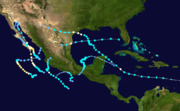 Landfall (meteorology) Landfall is the event of a tropical cyclone or a waterspout coming onto land after being over water. When a waterspout makes landfall it is reclassified as a tornado, which can then cause damage inland... in Mexico Mexico The United Mexican States , commonly known as Mexico , is a federal constitutional republic in North America. It is bordered on the north by the United States; on the south and west by the Pacific Ocean; on the southeast by Guatemala, Belize, and the Caribbean Sea; and on the east by the Gulf of... . A total of eight Pacific and North Atlantic tropical cyclones had a direct impact in Mexico in 2003, second only to 1971 when 9 did so. This compares to the long term average of 4.2 Atlantic and east Pacific storms affecting Mexico. Five Pacific storms impacted Mexico, of which Hurricanes Ignacio and Marty Hurricane Marty (2003) Hurricane Marty was the deadliest tropical cyclone of the 2003 Pacific hurricane season. Forming on September 18, it became the 13th tropical storm and fourth hurricane of the year... both hit the state of Baja California Sur Baja California Sur Baja California Sur , is one of the 31 states which, with the Federal District, comprise the 32 Federal Entities of Mexico. Before becoming a state on October 8, 1974, the area was known as the South Territory of Baja California. It has an area of , or 3.57% of the land mass of Mexico and comprises... as hurricanes. The combined damage from the two hurricanes totaled about $1 billion (2003 USD). Two other storms hit mainland Mexico as tropical storms and a third as a tropical depression. Three storms hit Mexico within a very short space of time, the Pacific hurricanes Nora and Olaf, and the Atlantic 2003 Atlantic hurricane season The 2003 Atlantic hurricane season was an active Atlantic hurricane season with tropical activity before and after the official bounds of the season – the first such occurrence in 50 years. The season produced 21 tropical cyclones, of which 16 developed into named storms; seven... Tropical Storm Larry Tropical Storm Larry (2003) Tropical Storm Larry was the twelfth tropical storm in the 2003 Atlantic hurricane season. It was one of eight storms to impact Mexico from either the Pacific or Atlantic Oceans in the season, a near-record. Larry formed in early October from an extratropical storm in the Bay of Campeche, and... . As a result of the flooding caused by these storms, disaster areas were declared in 14 states States of Mexico The United Mexican States is a federal republic formed by 32 federal entities .According to the Constitution of 1917, the states of the federation are free and sovereign. Each state has their own congress and constitution, while the Federal District has only limited autonomy with a local Congress... . Activity in the Central Pacific was below average, with only one tropical depression forming in the basin and one hurricane entering the basin from the east Pacific. In addition a third system, Tropical Storm Guillermo, weakened to a remnant low just to the east of the Central Pacific Hurricane Center Central Pacific Hurricane Center The Central Pacific Hurricane Center of the United States National Weather Service is the official body responsible for tracking and issuing tropical cyclone warnings, watches, advisories, discussions, and statements for the Central North Pacific Basin... 's area of responsibility. Although activity was generally low, Hurricane Jimena was the first direct threat to the Hawaiian Islands Hawaiian Islands The Hawaiian Islands are an archipelago of eight major islands, several atolls, numerous smaller islets, and undersea seamounts in the North Pacific Ocean, extending some 1,500 miles from the island of Hawaii in the south to northernmost Kure Atoll... for several years and a hurricane watch Tropical cyclone warnings and watches Warnings and watches are two levels of alert issued by national weather forecasting bodies to coastal areas threatened by the imminent approach of a tropical cyclone of tropical storm or hurricane intensity. They are notices to the local population and civil authorities to make appropriate... was issued for the island of Hawaii Hawaii (island) The Island of Hawaii, also called the Big Island or Hawaii Island , is a volcanic island in the North Pacific Ocean... . Jimena passed to the south, but still brought tropical storm force gusts and heavy rain to the island. Tropical Storm AndresA tropical wave developed into a tropical depression on May 19 well to the south of MexicoMexico The United Mexican States , commonly known as Mexico , is a federal constitutional republic in North America. It is bordered on the north by the United States; on the south and west by the Pacific Ocean; on the southeast by Guatemala, Belize, and the Caribbean Sea; and on the east by the Gulf of... as it moved west. A good outflow developed and it became a tropical storm the next day, before reaching its peak strength with winds of 60 mph (95 km/h). Increasing shear prevented any further development as the storm quickly west-northwest. On May 25 the shear and a reduction in water temperatures weakened Andres to a tropical depression and it dissipated soon after. The storm did not approach land.
Tropical Storm BlancaTropical Depression Two-E formed when an organized tropical wave interacted with another disturbance near the southwestern MexicanMexico The United Mexican States , commonly known as Mexico , is a federal constitutional republic in North America. It is bordered on the north by the United States; on the south and west by the Pacific Ocean; on the southeast by Guatemala, Belize, and the Caribbean Sea; and on the east by the Gulf of... coast early on June 17. The storm strengthened and became Tropical Storm Blanca 12 hours later. The storm moved slowly to the west and reached its peak on June 18 with 60 mph (95 km/h) winds. Although Blanca never developed a true eye Eye (cyclone) The eye is a region of mostly calm weather found at the center of strong tropical cyclones. The eye of a storm is a roughly circular area and typically 30–65 km in diameter. It is surrounded by the eyewall, a ring of towering thunderstorms where the second most severe weather of a cyclone... , at its peak there was a ring of convection resembling one. Under the influence of strong shear from the southeast Blanca began to weaken and move erratically. The storm degenerated to a remnant low on June 22 and lasted a further two days. There were no effects from Blanca on land.
Tropical Storm CarlosTropical Storm Carlos formed on June 26 from a tropical waveTropical wave Tropical waves, easterly waves, or tropical easterly waves, also known as African easterly waves in the Atlantic region, are a type of atmospheric trough, an elongated area of relatively low air pressure, oriented north to south, which move from east to west across the tropics causing areas of... to the south of Mexico. It quickly strengthened as it approached the coast, and early on June 27 Carlos moved ashore in Oaxaca Oaxaca Oaxaca , , officially Estado Libre y Soberano de Oaxaca is one of the 31 states which, along with the Federal District, comprise the 32 federative entities of Mexico. It is divided into 571 municipalities; of which 418 are governed by the system of customs and traditions... with winds of 65 mph (100 km/h). The storm rapidly deteriorated to a remnant low Low pressure area A low-pressure area, or "low", is a region where the atmospheric pressure at sea level is below that of surrounding locations. Low-pressure systems form under areas of wind divergence which occur in upper levels of the troposphere. The formation process of a low-pressure area is known as... , which persisted until dissipating on June 29. Carlos brought heavy rainfall to portions of southern Mexico, peaking at 337 mm (13.3 in) in two locations in Guerrero. Throughout its path, the storm damaged about 30,000 houses, with a monetary damage total of $86.7 million pesos (2003 MXN Mexican peso The peso is the currency of Mexico. Modern peso and dollar currencies have a common origin in the 15th–19th century Spanish dollar, most continuing to use its sign, "$". The Mexican peso is the 12th most traded currency in the world, the third most traded in the Americas, and by far the most... , $8 million 2003 USD). At least nine people were killed throughout the country, seven due to mudslides and two from river flooding; there was also a report of two missing fishermen. Tropical Storm DoloresConvection developed within an area of low pressure embedded in a tropical wave as it moved west. The disturbance organized into Tropical Depression Four-E on July 6 well to the south-southwest of the tip of the Baja California PeninsulaBaja California Peninsula The Baja California peninsula , is a peninsula in northwestern Mexico. Its land mass separates the Pacific Ocean from the Gulf of California. The Peninsula extends from Mexicali, Baja California in the north to Cabo San Lucas, Baja California Sur in the south.The total area of the Baja California... . It soon strengthened further into Tropical Storm Dolores as it moved to the northwest and reached its peak as a minimal tropical storm with winds of 40 mph (65 km/h). However wind shear had an adverse effect on Dolores and it weakened back into a depression 12 hours after becoming a tropical storm. The northwest motion brought it over colder water and it dissipated on July 9.
Tropical Storm EnriqueOn July 10, a tropical waveTropical wave Tropical waves, easterly waves, or tropical easterly waves, also known as African easterly waves in the Atlantic region, are a type of atmospheric trough, an elongated area of relatively low air pressure, oriented north to south, which move from east to west across the tropics causing areas of... formed into Tropical Depression Five-E. The storm became more organized and was named Tropical Storm Enrique the next day at an unusually high latitude. The storm continued to strengthen and at one point was forecast to briefly become a hurricane. This did not occur as the storm reached its peak strength with 65 mph (100 km/h) winds. It maintained this strength before moving over significantly cooler water late on July 12. Due to the cold water temperatures Enrique rapidly weakened, despite favorable atmospheric conditions. The storm degenerated into a remnant low late on July 13 and continued to move west before dissipating after a further 3 days. Enrique had no effects on land, but there were two ship reports of tropical storm force winds.
Tropical Storm FeliciaA tropical wave passed over Central AmericaCentral America Central America is the central geographic region of the Americas. It is the southernmost, isthmian portion of the North American continent, which connects with South America on the southeast. When considered part of the unified continental model, it is considered a subcontinent... on July 12 and started to become more organized two days later. It formed into a tropical depression on July 17 as it continued to move to the west. The depression became Tropical Storm Felicia the next day and as there was low shear over the system, the NHC predicted that it would become a minimal hurricane. However, the storm remained disorganized and peaked with 50 mph (85 km/h) winds late on July 18. The storm gradually weakened under increasing shear as it headed west, weakening back to a tropical depression on July 20. The remnant low entered the central Pacific before dissipating on July 24 well to the east of Hawaii Hawaii Hawaii is the newest of the 50 U.S. states , and is the only U.S. state made up entirely of islands. It is the northernmost island group in Polynesia, occupying most of an archipelago in the central Pacific Ocean, southwest of the continental United States, southeast of Japan, and northeast of... . Felicia had no affect on land.
Tropical Storm GuillermoA weak surface low developed within a tropical wave on August 6 and the convection associated with it became isolated from that of the wave. The circulation of the system became better defined a Tropical Depression Seven-E formed early the next day. Although the depression was initially forecast to dissipate quickly, it became more organized as it moved to the west. On August 8 it became Tropical Storm Guillermo and it reached its peak strength with 60 mph (95 km/h) winds that day. It maintained this strength for a full day, until outflow from the developing Tropical Storm Hilda to its east disrupted its convection. The remnant low entered the central Pacific shortly before dissipating on August 13.
Tropical Storm HildaA tropical wave developed persistent thunderstorm activity on August 5, which soon became more organized, forming into Tropical Depression Eight-E to the south of Cabo San LucasCabo San Lucas Cabo San Lucas , commonly called Cabo, is a city at the southern tip of the Baja California peninsula, in the municipality of Los Cabos in the Mexican state of Baja California Sur. As of the 2010 census, the population was 68,463 people... . An impressive outflow pattern caused the NHC to predict an intensification to hurricane strength, but strong easterly shear affected the system. The depression became Tropical Storm Hilda on August 10 but did not get any stronger than a minimal tropical storm with winds of 40 mph (65 km/h). Hilda moved west-northwest before it moved over colder waters, which caused it to weaken. Low-level flow forced the weakening cyclone westwards and it dissipated on August 13, having never approached land.
Tropical Depression One-CThe only tropical cyclone to form in the central Pacific in 2003 developed on August 15, and resulted from an interaction between remnants of Tropical Storm Guillermo and a non-tropical low. Unfavorable wind shear prevented the development of the depression and weakened as it drifted to the west. It weakened to a remnant low on August 17 and never regained depression strength. The remnant passed just south of Johnston AtollJohnston Atoll Johnston Atoll is a atoll in the North Pacific Ocean about west of Hawaii. There are four islands located on the coral reef platform, two natural islands, Johnston Island and Sand Island, which have been expanded by coral dredging, as well as North Island and East Island , an additional two... before it crossed the International Date Line International Date Line The International Date Line is a generally north-south imaginary line on the surface of the Earth, passing through the middle of the Pacific Ocean, that designates the place where each calendar day begins... on August 20. The storm had a minimal effect on the weather of the Hawaiian Islands Hawaiian Islands The Hawaiian Islands are an archipelago of eight major islands, several atolls, numerous smaller islets, and undersea seamounts in the North Pacific Ocean, extending some 1,500 miles from the island of Hawaii in the south to northernmost Kure Atoll... .
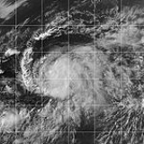
Hurricane IgnacioA tropical wave organized into a distinct area of disturbed weather just south of the MexicanMexico The United Mexican States , commonly known as Mexico , is a federal constitutional republic in North America. It is bordered on the north by the United States; on the south and west by the Pacific Ocean; on the southeast by Guatemala, Belize, and the Caribbean Sea; and on the east by the Gulf of... port of Manzanillo, Colima Manzanillo, Colima The name Manzanillo refers to the city as well as its surrounding municipality in the Mexican state of Colima. The city, located on the Pacific Ocean, contains Mexico's busiest port. Manzanillo was the third port created by the Spanish in the Pacific during the New Spain period... , on August 22 and gradually moved to the northwest. It became Tropical Depression Nine-E off Cabo Corrientes Cabo Corrientes Cabo Corrientes is a cape on the Pacific coast of the Mexican state of Jalisco. It marks the southernmost point of the Bahía de Banderas, upon which the port and resort city of Puerto Vallarta stands. The municipality in which the cape lies is also called Cabo Corrientes.Cabo Corrientes is a... in the state of Jalisco Jalisco Jalisco officially Estado Libre y Soberano de Jalisco is one of the 31 states which, with the Federal District, comprise the 32 Federal Entities of Mexico. It is located in Western Mexico and divided in 125 municipalities and its capital city is Guadalajara.It is one of the more important states... two days later and under the influence of favorable atmospheric conditions rapidly strengthened. It was named Tropical Storm Ignacio on August 25 before it peaked as a 105 mph (165 km/h) hurricane on August 26, the first of the season. Ignacio entered the southern Gulf of California Gulf of California The Gulf of California is a body of water that separates the Baja California Peninsula from the Mexican mainland... before it made landfall just to the east of La Paz, Baja California Sur La Paz, Baja California Sur La Paz is the capital city of the Mexican state of Baja California Sur and an important regional commercial center. The city had a 2010 census population of 215,178 persons, but its metropolitan population is somewhat larger because of surrounding towns like el Centenario, el Zacatal and San Pedro... . Ignacio weakened overland and dissipated early on August 28 over central Baja California Baja California Baja California officially Estado Libre y Soberano de Baja California is one of the 31 states which, with the Federal District, comprise the 32 Federal Entities of Mexico. It is both the northernmost and westernmost state of Mexico. Before becoming a state in 1953, the area was known as the North... . Due to the storm’s slow movement, rainfall was high and the resulting flooding was severe, and Ignacio was responsible for approximately $21 million (USD United States dollar The United States dollar , also referred to as the American dollar, is the official currency of the United States of America. It is divided into 100 smaller units called cents or pennies.... ) of damage. Two rescue workers drowned in the flood waters brought by the storm and some 10,000 people were evacuated to shelters.
Hurricane JimenaOn August 28, an area of disturbed weather within the Intertropical Convergence ZoneIntertropical Convergence Zone The Intertropical Convergence Zone , known by sailors as The Doldrums, is the area encircling the earth near the equator where winds originating in the northern and southern hemispheres come together.... developed into Tropical Depression Ten-E, some 1725 miles (2775 km) east of the Hawaiian Islands Hawaiian Islands The Hawaiian Islands are an archipelago of eight major islands, several atolls, numerous smaller islets, and undersea seamounts in the North Pacific Ocean, extending some 1,500 miles from the island of Hawaii in the south to northernmost Kure Atoll... . The storm rapidly developed over warm ocean waters, gaining an eye shortly before it became Hurricane Jimena on August 29. The storm moved to the west, entering the central Pacific as it continued to strengthen. After reaching its peak strength with 105 mph (165 km/h) winds 800 miles (1300 km) to the east of Hawaii it began to weaken as a result of increased shear. The storm passed about 120 miles (195 km) to the south of the southern tip of Hawaii Hawaii (island) The Island of Hawaii, also called the Big Island or Hawaii Island , is a volcanic island in the North Pacific Ocean... on September 1, just after losing hurricane strength. The storm then moved west, south of the archipelago, becoming a tropical depression on September 3. The weakening Jimena crossed the International Date Line International Date Line The International Date Line is a generally north-south imaginary line on the surface of the Earth, passing through the middle of the Pacific Ocean, that designates the place where each calendar day begins... before dissipating on September 5. The storm brought 6 to 10 inches (150 to 250 mm) of rain and 11 foot (3.3 m) surf to the island of Hawaii. There were also tropical storm force winds recorded on several of the Hawaiian Islands, but there was no significant damage.
Tropical Storm KevinA large low pressure area developed within a tropical wave and organized slowly into Tropical Depression Eleven-E on September 3 south-southwest of the tip of Baja California. The broad wind field prevented rapid intensification and the system reached tropical storm strength on September 4. Although wind shear was light, Kevin weakened into a depression after just six hours, as it moved over colder waters. On September 6 the system degenerated to a non-convective low pressure area, which managed to survive for four days before finally dissipating. Tropical Storm Kevin had no effects on land.
Hurricane LindaConvection began to increase in a tropical wave on September 9 and a few days later a surface low developed. On September 12 it organized into Tropical Depression Twelve-E to the southwest of the MexicanMexico The United Mexican States , commonly known as Mexico , is a federal constitutional republic in North America. It is bordered on the north by the United States; on the south and west by the Pacific Ocean; on the southeast by Guatemala, Belize, and the Caribbean Sea; and on the east by the Gulf of... port of Manzanillo, Colima Manzanillo, Colima The name Manzanillo refers to the city as well as its surrounding municipality in the Mexican state of Colima. The city, located on the Pacific Ocean, contains Mexico's busiest port. Manzanillo was the third port created by the Spanish in the Pacific during the New Spain period... . The cyclone moved to the northwest, becoming a tropical storm on September 14 before reaching its peak strength as a Category 1 Saffir-Simpson Hurricane Scale The Saffir–Simpson Hurricane Scale , or the Saffir–Simpson Hurricane Wind Scale , classifies hurricanes — Western Hemisphere tropical cyclones that exceed the intensities of tropical depressions and tropical storms — into five categories distinguished by the intensities of their sustained winds... hurricane with 75 mph (120 km/h) winds. The National Hurricane Center predicted further strengthening, but this did not occur and Linda weakened back to a tropical storm after just 12 hours as a hurricane. As the storm continued to weaken it turned to the west and then to the southwest, becoming a tropical depression on September 17. The remnant drifted to the southwest and finally dissipated on September 26. There were no reports of any effects from this storm.
Hurricane MartyA tropical wave moved into the Pacific Ocean on September 10 and the convection associated with it gradually increased. By September 16, while the system was south-southeast of Cabo San LucasCabo San Lucas Cabo San Lucas , commonly called Cabo, is a city at the southern tip of the Baja California peninsula, in the municipality of Los Cabos in the Mexican state of Baja California Sur. As of the 2010 census, the population was 68,463 people... , it organized into Tropical Depression Thirteen-E. The depression strengthened as it headed towards the Baja California Peninsula Baja California Peninsula The Baja California peninsula , is a peninsula in northwestern Mexico. Its land mass separates the Pacific Ocean from the Gulf of California. The Peninsula extends from Mexicali, Baja California in the north to Cabo San Lucas, Baja California Sur in the south.The total area of the Baja California... , becoming a tropical storm on September 19 and a hurricane two days later. Hurricane Marty reached its peak strength on September 22, just before it made landfall at Cabo San Lucas Cabo San Lucas Cabo San Lucas , commonly called Cabo, is a city at the southern tip of the Baja California peninsula, in the municipality of Los Cabos in the Mexican state of Baja California Sur. As of the 2010 census, the population was 68,463 people... , when it was packing winds of 100 mph (155 km/h). After moving over the southern tip of the peninsula Marty moved up the western coast of the Gulf of California Gulf of California The Gulf of California is a body of water that separates the Baja California Peninsula from the Mexican mainland... , gradually weakening as it did so. The storm weakened to a tropical depression on September 23 and dissipated two days later after meandering over the northern Gulf. Hurricane Marty was the deadliest storm of the 2003 Pacific hurricane season and was responsible for 12 deaths and either damaged or destroyed over 4,000 homes. It brought heavy rainfall to the entire region and some rain affected the Southwest United States. A 5 foot (1.5 m) storm surge Storm surge A storm surge is an offshore rise of water associated with a low pressure weather system, typically tropical cyclones and strong extratropical cyclones. Storm surges are caused primarily by high winds pushing on the ocean's surface. The wind causes the water to pile up higher than the ordinary sea... flooded parts of La Paz, Baja California Sur La Paz, Baja California Sur La Paz is the capital city of the Mexican state of Baja California Sur and an important regional commercial center. The city had a 2010 census population of 215,178 persons, but its metropolitan population is somewhat larger because of surrounding towns like el Centenario, el Zacatal and San Pedro... , and sank 35 yacht Yacht A yacht is a recreational boat or ship. The term originated from the Dutch Jacht meaning "hunt". It was originally defined as a light fast sailing vessel used by the Dutch navy to pursue pirates and other transgressors around and into the shallow waters of the Low Countries... s moored in various ports. Marty was also the costliest east Pacific storm of the year and was responsible for $50 million of damage in western Mexico.
Hurricane NoraA tropical wave moved over Central AmericaCentral America Central America is the central geographic region of the Americas. It is the southernmost, isthmian portion of the North American continent, which connects with South America on the southeast. When considered part of the unified continental model, it is considered a subcontinent... on September 25 and moved parallel to the south Mexican coast. It became more organized on October 1 and developed into Tropical Depression Fourteen-E to the south of the Baja California Peninsula Baja California Peninsula The Baja California peninsula , is a peninsula in northwestern Mexico. Its land mass separates the Pacific Ocean from the Gulf of California. The Peninsula extends from Mexicali, Baja California in the north to Cabo San Lucas, Baja California Sur in the south.The total area of the Baja California... . It continued to strengthen as it moved northwest in favorable conditions, becoming a tropical storm the next day. On October 4 it became a hurricane and reached its peak that day with 105 mph (165 km/h) winds. Nora made a sharp turn to the east and began to weaken, as the result of the influence of a mid-level trough and the outflow from Hurricane Olaf to the southeast. The cyclone rapidly weakened before it made landfall just north of Mazatlán, Sinaloa Mazatlán Mazatlán is a city in the Mexican state of Sinaloa; the surrounding municipio for which the city serves as the municipal seat is Mazatlán Municipality. It is located at on the Pacific coast, across from the southernmost tip of the Baja California peninsula.Mazatlán is a Nahuatl word meaning... , on October 9. Nora dissipated over land soon after landfall. Hurricane Nora was the strongest storm of the season and brought heavy rain to the state of Sinaloa Sinaloa Sinaloa officially Estado Libre y Soberano de Sinaloa is one of the 31 states which, with the Federal District, comprise the 32 Federal Entities of Mexico. It is divided in 18 municipalities and its capital city is Culiacán Rosales.... , but there was no significant damage or casualties.
Hurricane OlafA tropical wave became increasingly organized on October 2 to the south-southeast of AcapulcoAcapulco Acapulco is a city, municipality and major sea port in the state of Guerrero on the Pacific coast of Mexico, southwest from Mexico City. Acapulco is located on a deep, semi-circular bay and has been a port since the early colonial period of Mexico’s history... and developed into Tropical Depression Fifteen-E the next day. The depression strengthened into Tropical Storm Olaf six hours after forming as it moved to the northwest in a low shear environment. Olaf reached its peak strength as a minimal hurricane with 75 mph (120 km/h) winds on October 5 and developed a partial eyewall. The storm soon became disorganized and was only a hurricane for a few hours, before turning towards the Mexican coast. Olaf made landfall near Manzanillo, Colima Manzanillo, Colima The name Manzanillo refers to the city as well as its surrounding municipality in the Mexican state of Colima. The city, located on the Pacific Ocean, contains Mexico's busiest port. Manzanillo was the third port created by the Spanish in the Pacific during the New Spain period... , on October 7 and soon dissipated overland. The storm caused severe flooding in the states of Jalisco Jalisco Jalisco officially Estado Libre y Soberano de Jalisco is one of the 31 states which, with the Federal District, comprise the 32 Federal Entities of Mexico. It is located in Western Mexico and divided in 125 municipalities and its capital city is Guadalajara.It is one of the more important states... and Guanajuato Guanajuato Guanajuato officially Estado Libre y Soberano de Guanajuato is one of the 31 states which, with the Federal District, comprise the 32 Federal Entities of Mexico. It is divided in 46 municipalities and its capital city is Guanajuato.... which damaged crops, roads and over 12,000 houses. However, there were no deaths as a result of Hurricane Olaf.
Hurricane PatriciaOn October 20 the convection associated with a tropical wave became more organized and Tropical Depression Sixteen-E formed to the south of AcapulcoAcapulco Acapulco is a city, municipality and major sea port in the state of Guerrero on the Pacific coast of Mexico, southwest from Mexico City. Acapulco is located on a deep, semi-circular bay and has been a port since the early colonial period of Mexico’s history... . It soon became Tropical Storm Patricia and reached hurricane strength on October 21, as it moved further west. 12 hours later, its winds had increased to 80 mph (130 km/h) and the NHC forecast further strengthening. However on October 22, increasing westerly shear caused Patricia to weaken to below hurricane strength. The storm weakened further to a depression on October 25 and it dissipated the next day, ending the season. Hurricane Patricia had no effects on land.
Accumulated Cyclone Energy (ACE) ranking
The table on the right shows the Accumulated Cyclone Energy Accumulated cyclone energy Accumulated cyclone energy is a measure used by the National Oceanic and Atmospheric Administration to express the activity of individual tropical cyclones and entire tropical cyclone seasons, particularly the North Atlantic hurricane season. It uses an approximation of the energy used by a... (ACE) for each storm in the season. The total ACE for the 2003 season was 56.6 x 10⁴ kt2, making the 2003 East Pacific season one of the least active since 1980. The ACE is, broadly speaking, a measure of the power of the storm multiplied by the length of time it existed for, so hurricanes that lasted a long time have higher ACEs. Hurricane Jimena had the highest overall ACE of the season with a total of 9.28 x 10⁴ kt2. Of this total, Jimena's ACE was 3.265 x 10⁴ kt2 in the Eastern Pacific and 6.015 x 10⁴ kt2 in the Central Pacific. This means that whilst Jimena had the highest overall ACE, it only rated 7th highest in the Eastern Pacific, with Hurricane Nora having the highest ACE in that basin. As Hurricane Jimena was the only storm in 2003 to exist in the Central Pacific as a tropical storm or hurricane, the total ACE for the Central Pacific was 6.015 x 10⁴ kt2. The total ACE in the Eastern Pacific was 50.6 x 10⁴ kt2. Source of data: Best track data from the National Hurricane Center's Tropical Cyclone Reports. Storm namesThe following list of names was used to name storms that formed in the northeast Pacific in 2003. Names that were not assigned are marked in gray. No names were retired by the World Meteorological OrganizationWorld Meteorological Organization The World Meteorological Organization is an intergovernmental organization with a membership of 189 Member States and Territories. It originated from the International Meteorological Organization , which was founded in 1873... , therefore this list will be used again in the 2009 Pacific hurricane season. This is the same list which was used for the 1997 season 1997 Pacific hurricane season The 1997 Pacific hurricane season was a very active hurricane season. With hundreds of deaths and billions of dollars in damage, this season was the costliest and one of the deadliest Pacific hurricane seasons. This was due to a strong El Niño... except for Patricia, which replaced Pauline Hurricane Pauline Hurricane Pauline was one of the strongest and deadliest Pacific hurricanes to make landfall on Mexico. The sixteenth tropical storm, eighth hurricane, and seventh major hurricane of the 1997 Pacific hurricane season, Pauline developed out of a tropical wave on October 5 about 250 miles ... . A storm was named Patricia for the first time in 2003.
No central Pacific names were used; the first name used would have been Ioke. See also
External links
The source of this article is wikipedia, the free encyclopedia. The text of this article is licensed under the GFDL.
| |||||||||||||||||||||||||||||||||||||||||||||||||||||||||