
2002 Denali earthquake
Encyclopedia
The 2002 Denali earthquake occurred at 22:12:41 UTC (1:12 PM Local Time
) November 3, 2002, with an epicenter
66 km ESE of Denali National Park, Alaska
, United States. This 7.9 Mw
earthquake was the largest recorded in the interior of the United States
for more than 150 years. The shock was the strongest ever recorded in the interior of Alaska. There were no fatalities and only a few injuries due to the remote location.
 Minor damage was reported over a wide area but the only examples of severe damage were on highways that crossed the fault trace and areas that suffered liquefaction
, e.g. Northway Airport
. Several bridges were damaged but none so severely that they were closed to traffic.
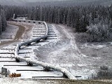
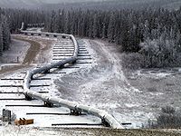
The Trans-Alaska Pipeline System
crosses the rupture trace; the pipeline suffered some minor damage to supports during the earthquake. There was no oil spillage, as the pipeline at that location was designed to move laterally along beams to withstand major movement on the Denali Fault. The pipeline was shut down for three days to allow for inspections but was then reopened.
is a major dextral (right lateral) strike-slip system, similar in scale to the San Andreas fault
system.
In Alaska, moving from east to west, the plate interactions change from a transform boundary between Pacific and North American plates to a collision zone with a microplate, the Yakutat terrane
, which is in the process of being accreted to the North American plate, to a destructive boundary along the line of the Aleutian islands. The Denali-Totschunda fault system is one of the structures that accommodate the accretion of the Yakutat terrane.
that probably directly triggered the main shock.
The initial rupture on November 3 was on a thrust fault segment, the previously unknown Susitna Glacier
thrust, to the south of the Denali fault. The epicenter lies just 25 kilometres (16 mi) east of the October 23 foreshock. The rupture then jumped to the main Denali fault strand propagating for a further 220 km (137 mi) before jumping again onto the Totschunda fault and rupturing another 70 km (43 mi) of fault plane. The total surface rupture was ca. 340 km (211 mi).
There is evidence of local supershear
propagation inferred from ground motions.
Alaska Time Zone
The Alaska Time Zone observes standard time by subtracting nine hours from Coordinated Universal Time . During daylight saving time its time offset is only eight hours . The clock time in this zone is based on the mean solar time of the 135th meridian west of the Greenwich Observatory.The zone...
) November 3, 2002, with an epicenter
Epicenter
The epicenter or epicentre is the point on the Earth's surface that is directly above the hypocenter or focus, the point where an earthquake or underground explosion originates...
66 km ESE of Denali National Park, Alaska
Alaska
Alaska is the largest state in the United States by area. It is situated in the northwest extremity of the North American continent, with Canada to the east, the Arctic Ocean to the north, and the Pacific Ocean to the west and south, with Russia further west across the Bering Strait...
, United States. This 7.9 Mw
Moment magnitude scale
The moment magnitude scale is used by seismologists to measure the size of earthquakes in terms of the energy released. The magnitude is based on the seismic moment of the earthquake, which is equal to the rigidity of the Earth multiplied by the average amount of slip on the fault and the size of...
earthquake was the largest recorded in the interior of the United States
United States
The United States of America is a federal constitutional republic comprising fifty states and a federal district...
for more than 150 years. The shock was the strongest ever recorded in the interior of Alaska. There were no fatalities and only a few injuries due to the remote location.
Earthquake damage
Liquefaction
Liquefaction may refer to:* Liquefaction, the general process of becoming liquid* Soil liquefaction, the process by which sediments become suspended* Liquefaction of gases in physics, chemistry, and thermal engineering* Liquefactive necrosis in pathology...
, e.g. Northway Airport
Northway Airport
Northway Airport is a state-owned public-use airport located in Northway, in the Southeast Fairbanks Census Area of the U.S. state of Alaska.As per Federal Aviation Administration records, this airport had 55 commercial passenger boardings in calendar year 2010, an increase of 511% from the 9...
. Several bridges were damaged but none so severely that they were closed to traffic.
The Trans-Alaska Pipeline System
Trans-Alaska Pipeline System
The Trans Alaska Pipeline System , includes the Trans Alaska Pipeline, 11 pump stations, several hundred miles of feeder pipelines, and the Valdez Marine Terminal. TAPS is one of the world's largest pipeline systems...
crosses the rupture trace; the pipeline suffered some minor damage to supports during the earthquake. There was no oil spillage, as the pipeline at that location was designed to move laterally along beams to withstand major movement on the Denali Fault. The pipeline was shut down for three days to allow for inspections but was then reopened.
Tectonic setting
The Denali-Totschunda faultDenali Fault
The Denali Fault is a major intracontinental dextral strike-slip fault in western North America, extending from northwestern British Columbia, Canada to the U.S. state of central Alaska. It was the main fault along which the 2002 Denali earthquake occurred, which was measured as a magnitude of 7.9...
is a major dextral (right lateral) strike-slip system, similar in scale to the San Andreas fault
San Andreas Fault
The San Andreas Fault is a continental strike-slip fault that runs a length of roughly through California in the United States. The fault's motion is right-lateral strike-slip...
system.
In Alaska, moving from east to west, the plate interactions change from a transform boundary between Pacific and North American plates to a collision zone with a microplate, the Yakutat terrane
Yakutat Block
The Yakutat Block is a terrane in the process of accreting to the North American continent along the south central coast of Alaska. It has been displaced about 600 km northward since the Cenozoic along the Queen Charlotte-Fairweather fault system....
, which is in the process of being accreted to the North American plate, to a destructive boundary along the line of the Aleutian islands. The Denali-Totschunda fault system is one of the structures that accommodate the accretion of the Yakutat terrane.
Earthquake characteristics
On October 23, 2002, there was a magnitude 6.7 earthquake located on the Denali fault. Because of its location close to the November 3 event and the fact that it preceded it by only 11 days, this earthquake is regarded as a foreshockForeshock
A foreshock is an earthquake that occurs before a larger seismic event and is related to it in both time and space. The designation of an earthquake as foreshock, mainshock or aftershock is only possible after the event....
that probably directly triggered the main shock.
The initial rupture on November 3 was on a thrust fault segment, the previously unknown Susitna Glacier
Susitna Glacier
Susitna Glacier is an alpine or valley glacier in the Alaska Range. Susitna Glacier flows over a seismically active area. The 7.9-magnitude 2002 Denali earthquake struck the region in November 2002. The earthquake initiated with thrust movement on the previously unrecognized Susitna Glacier fault ....
thrust, to the south of the Denali fault. The epicenter lies just 25 kilometres (16 mi) east of the October 23 foreshock. The rupture then jumped to the main Denali fault strand propagating for a further 220 km (137 mi) before jumping again onto the Totschunda fault and rupturing another 70 km (43 mi) of fault plane. The total surface rupture was ca. 340 km (211 mi).
There is evidence of local supershear
Supershear earthquake
A supershear earthquake is an earthquake in which the propagation of the rupture along the fault surface occurs at speeds in excess of the seismic shear wave velocity. This causes a form of sonic boom to occur.-Rupture propagation velocity:...
propagation inferred from ground motions.
External links
- The 2002 Denali Fault earthquake Magnitude 7.9 near Denali National Park, AK USGS page on the 2002 Denali Earthquake
- AEIC page on the Denali earthquake