
1993 North American storm complex
Encyclopedia
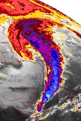
The Storm of the Century, also known as the ’93 Superstorm, or the (Great) Blizzard
of 1993, was a large cyclonic
storm
that occurred on March 12–13, 1993, on the East Coast of North America
. It is unique for its intensity, massive size and wide-reaching effect. At its height, the storm
stretched from Canada
towards Central America
, but its main impact was on the Eastern United States
and Cuba
. The cyclone
moved through the Gulf of Mexico, and then through the Eastern United States before moving into Canada. Areas as far south as central Alabama and Georgia received 6 to 8 in (15.2 to 20.3 cm) of snow
and areas such as Birmingham, Alabama
, received up to 12 inches (30.5 cm) with isolated reports of 16 inches (40.6 cm). Even the Florida Panhandle
reported up to 4 inches (10.2 cm), with hurricane-force wind gusts and record low barometric pressures. Between Louisiana
and Cuba
, hurricane-force winds produced high storm surges across northwestern Florida
, which along with scattered tornado
es killed dozens of people. Record cold temperatures were seen across portions of the South and East in the wake of this storm. In the United States
, the storm was responsible for the loss of electric power
to over 10 million customers. It is purported to have been directly experienced by nearly 40 percent of the country's population at that time. A total of 310 people, including 10 from Cuba, perished during this storm.
. By March 8 (and by some accounts even earlier), several operational numerical weather prediction
models and medium-range forecasters at the US National Weather Service
recognized the threat of a significant snowstorm. By March 12, many had reviewed the data and were convinced that a serious threat loomed overhead. This marked the first time that National Weather Service meteorologists were able to predict accurately a system's severity five days in advance. Official blizzard warning
s were issued two days before the storm arrived, as shorter-range models began to confirm the predictions. Forecasters were finally confident enough in the computer-forecast models to support decisions by several Northeastern U.S. states to declare a State of Emergency
before the snow even started to fall.
In the South, however, temperatures in the days before the storm were typical for early March. Although large fluctuations in temperature are not unusual in the deep south, many residents doubted that freezing temperatures could return so rapidly or that snow was likely due to the rarity of significant snowfall later than February. Many local TV news stations were reluctant to even broadcast the forecast models, due to the extreme numbers being predicted by the computers, but the models turned out to be right.
high pressure system
built into the Midwest and Great Plains
. The extratropical
area of low pressure
formed in Mexico
and moved eastward into the Gulf of Mexico along a stationary front
, which developed thunderstorm activity near its center. A strong shortwave trough in the southern branch of the polar jet stream accelerated the strengthening of the surface low. As the area of low pressure moved through the central Gulf of Mexico, a shortwave trough in the northern branch of the jet stream phased with the system in the southern stream, which continued significant strengthening of the surface low. A squall line
developed along the system's cold front
, which moved rapidly across the eastern Gulf of Mexico through Florida and Cuba. The cyclone's center moved into northwest Florida by early on the morning of March 13, taking a significant storm surge
into the northwestern Florida peninsula, which drowned
several people.
Barometric pressures recorded during the storm were quite low: readings of 976 mb were recorded in Tallahassee, Florida
and lower readings of 960 mb were observed in New England. Usually, such low readings near the coast of the Gulf of Mexico
are observed only in hurricanes of Category 2 intensity on the Saffir-Simpson hurricane scale
, or within cyclonic storms out to sea. As this happened snow began to spread over the eastern United States, and a large squall line moved from over the Gulf of Mexico into Florida and Cuba. The low tracked up the east coast during the day on Saturday and into Canada by early Monday morning. In the storm's wake, cold temperatures for so late in the winter overspread the Southeast for a day or two.
states and much of eastern Canada
. Bringing cold air along with heavy precipitation and hurricane force winds, it caused a blizzard
over much of the area it affected, including thundersnow
from Texas
to Pennsylvania
and widespread whiteout
conditions. Snow fell as far south and east as Jacksonville, Florida
, and areas of the Florida Panhandle
got several inches of snow, making it the most significant winter storm to affect the state since 1899. Ice pellets (sleet) mixed in with the rain as temperatures in Tampa, in west-central Florida, hovered not far above freezing after the front passed.
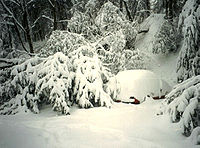
Some affected areas in the Appalachian region saw more than 3.5 feet (1.1 m) of snow, and snowdrifts were as high as 35 feet (10.7 m). Every airport
from Halifax, Nova Scotia to Atlanta, Georgia was closed for some time because of the storm. The volume
of the storm's total snowfall was later computed to be 12.91 cubic miles (53.8 km³), an amount which would weigh (depending on the variable density
of snow) between 5.4 and 27 billion tonne
s.
In the South, where public works facilities (in most areas) generally have no reason to be prepared for snow removal, the storm is vividly remembered because it resulted in a complete shutdown of that region for three days. Cities that usually receive little snowfall, such as Chattanooga, Tennessee
, received anywhere from 2 to 4 ft (0.6096 to 1.2 m) of snow, causing some municipalities to adopt at least an emergency winter-weather plan for the future where one might not have existed before. Birmingham, Alabama
, which normally receives 1 inches (2.5 cm) in a year, received 13 inches (33 cm), shattering the records for most snow in a single storm, a single month, and even a single season. The psychological impact in the Southern states, where average high temperatures in March tend to run into the 60s Fahrenheit
(the upper teens Celsius
), was magnified by the fact that it struck a week before spring. Syracuse, New York
, which is accustomed to heavy snowfall due to yearly lake-effect snow storms, received a record 43 inches (109.2 cm) from the storm, while snowfall totaled over 12 inches (30.5 cm) in New York City
and 2 foot (0.6096 m) of snow fell in Hartford, Connecticut
and Pittsburgh, Pennsylvania.
The weight of record snows collapsed many factory
roof
s in the South, and snowdrift
s on the windward sides of buildings caused a few decks
with substandard anchor
s to fall from homes. Though the storm was forecast to strike the snow-prone Appalachian Mountains
, hundreds of people were nonetheless rescue
d from the Appalachians, many caught completely off guard on the Appalachian Trail
, or visiting cabins and lodges in remote locales. Drifts up to 14 feet (4.3 m) were observed at Mount Mitchell
. Snowfall totals of between 2 and 3 ft (0.6096 and 0.9144 m) were widespread across northwestern North Carolina. Boone, North Carolina
—in a high-elevation area accustomed to heavy snowfalls—was nonetheless caught off guard by 36"+ of snow and 24 hours of temperatures below 0 °F (-17.8 °C) along with storm winds which (according to NCDC
storm summaries) gusted as high as 110 miles per hour (177 km/h). Electricity was not restored to many isolated rural
areas for a week or more, with power cuts occurring all over the east. Nearly 60,000 lightning strikes were recorded as the storm swept over the country for a total of seventy-two hours, and many may remember their local news organizations touting the term "thundersnow
." As one of the most powerful storms in recent history, the storm has been described as the "Storm of the Century
" by many of the areas affected.
Across the Northeastern states and eastern Canadian provinces, the storm put down an average of 15 inches (38.1 cm) of snow, which, though most certainly heavy, is not exceptional by most local standards, but still somewhat unusual for mid-March, especially in the southernmost parts of the region such as the Baltimore-Washington area. In southeastern Ontario
and southwestern Quebec
, where less severe winter blizzards are relatively common, snowfalls of more than 15 inches (38.1 cm) in Montreal
and Ottawa
were nevertheless far above average and came second only to record amounts set during the deadly Eastern Canadian Blizzard of March 1971
, an exceptionally brutal Nor'easter
still locally referred to in Quebec and parts of New York State as the "Storm of the Century". The lowest temperature recorded during the horrific storm was below 10 Fahrenheit.
dealt with "aboslutely incredible, unbelievable" conditions within the Gulf of Mexico. The 200-ft. freighter Fantastico sank 70 miles offshore Ft. Myers, Florida during the storm. Seven of its crew died when a Coast Guard helicopter was forced back to base due to low fuel levels after rescuing three of their crew. The 147-ft. freighter Miss Beholding ran aground on a coral reef
ten miles from Key West, Florida
. Several other smaller vessels sank within the rough seas. In all, the Coast Guard rescued 235 people from over 100 boats across the Gulf of Mexico during the tempest.
states, and one of the nation's biggest snowstorms, the low produced a potent squall line ahead of its cold front
. The squall line
produced a serial derecho
as it moved into Florida and Cuba shortly after midnight on March 13. Straight-line winds gusted above 100 mph (100 miles per hour (82.1 kn), 100 miles per hour (160.9 km/h)) at many locations in Florida
as the squall line
moved through. The supercell
s in the derecho produced eleven tornado
es in the United States. One tornado killed three people when it struck a home which later collapsed, pinning the occupants under a fallen wall. A substantial tree fall was seen statewide from this system.
A substantial storm surge
was also generated along the gulf coast from Apalachee Bay
in the Florida panhandle to south of Tampa Bay
. Due to the angle of the coast relative to the approaching squall, Taylor County
along the eastern portion of Apalachee Bay
and Hernando County north of Tampa
were especially hard hit.
Storm surges in those areas reached up to 12 feet (3.7 m); higher than many hurricanes. With little advance warning of incoming severe conditions, some coastal residents were awakened in the early morning of March 13 by the waters of the Gulf of Mexico
rushing into their homes. More people died from drowning in this storm than during Hurricane Hugo
and Hurricane Andrew
combined. Overall, the storm's surge, winds, and tornadoes damaged or destroyed 18,000 homes. A total of 47 lives were lost in Florida due to this storm.
area. A survey conducted by a research team from the Institute of Meteorology of Cuba suggests that the maximum winds could have been as high as 130 miles per hour (209.2 km/h). It is the most damaging squall line ever recorded in Cuba.
There was widespread and significant damage in Cuba, with damages estimated as intense as F2
. The squall line finally moved out of Cuba near sunrise, leaving 10 deaths and US$1 billion in damage on the island.
 Temperatures accompanying the storm were unseasonably cold for late winter so close to spring: average daily maximum temperatures, in mid-March, are around 46 °F (7.8 °C) in Boston
, 51 °F (10.6 °C) in Philadelphia, and 65 °F (18.3 °C) in Atlanta. During the 1993 storm, these places were all below freezing, and parts of New England
saw daily maximum temperatures as low as 14 °F (-10 °C). Record low temperatures for March were recorded in much of the southern U.S. Birmingham
recorded a record low of 2 °F (-16.7 °C) during the storm.
of 1993 caused a total of US$6.6 billion of damage. For their part, New England
residents tend to point to the Blizzard of 1978
as their "storm of the century," due largely to its unrelenting snowfall, which temporarily dislocated the weather-hardened region, while Mid-Atlantic
residents tend to point to the Blizzard of 1996 for similar reasons. Eastern Canadians, in particular Quebecers, refer to the Blizzard of 1971
. The last blizzard to have such an effect on the Southeast was the Great Blizzard of 1899
.
Blizzard
A blizzard is a severe snowstorm characterized by strong winds. By definition, the difference between blizzard and a snowstorm is the strength of the wind. To be a blizzard, a snow storm must have winds in excess of with blowing or drifting snow which reduces visibility to 400 meters or ¼ mile or...
of 1993, was a large cyclonic
Cyclone
In meteorology, a cyclone is an area of closed, circular fluid motion rotating in the same direction as the Earth. This is usually characterized by inward spiraling winds that rotate anticlockwise in the Northern Hemisphere and clockwise in the Southern Hemisphere of the Earth. Most large-scale...
storm
Storm
A storm is any disturbed state of an astronomical body's atmosphere, especially affecting its surface, and strongly implying severe weather...
that occurred on March 12–13, 1993, on the East Coast of North America
North America
North America is a continent wholly within the Northern Hemisphere and almost wholly within the Western Hemisphere. It is also considered a northern subcontinent of the Americas...
. It is unique for its intensity, massive size and wide-reaching effect. At its height, the storm
Storm
A storm is any disturbed state of an astronomical body's atmosphere, especially affecting its surface, and strongly implying severe weather...
stretched from Canada
Canada
Canada is a North American country consisting of ten provinces and three territories. Located in the northern part of the continent, it extends from the Atlantic Ocean in the east to the Pacific Ocean in the west, and northward into the Arctic Ocean...
towards Central America
Central America
Central America is the central geographic region of the Americas. It is the southernmost, isthmian portion of the North American continent, which connects with South America on the southeast. When considered part of the unified continental model, it is considered a subcontinent...
, but its main impact was on the Eastern United States
Eastern United States
The Eastern United States, the American East, or simply the East is traditionally defined as the states east of the Mississippi River. The first two tiers of states west of the Mississippi have traditionally been considered part of the West, but can be included in the East today; usually in...
and Cuba
Cuba
The Republic of Cuba is an island nation in the Caribbean. The nation of Cuba consists of the main island of Cuba, the Isla de la Juventud, and several archipelagos. Havana is the largest city in Cuba and the country's capital. Santiago de Cuba is the second largest city...
. The cyclone
Cyclone
In meteorology, a cyclone is an area of closed, circular fluid motion rotating in the same direction as the Earth. This is usually characterized by inward spiraling winds that rotate anticlockwise in the Northern Hemisphere and clockwise in the Southern Hemisphere of the Earth. Most large-scale...
moved through the Gulf of Mexico, and then through the Eastern United States before moving into Canada. Areas as far south as central Alabama and Georgia received 6 to 8 in (15.2 to 20.3 cm) of snow
Snow
Snow is a form of precipitation within the Earth's atmosphere in the form of crystalline water ice, consisting of a multitude of snowflakes that fall from clouds. Since snow is composed of small ice particles, it is a granular material. It has an open and therefore soft structure, unless packed by...
and areas such as Birmingham, Alabama
Birmingham, Alabama
Birmingham is the largest city in Alabama. The city is the county seat of Jefferson County. According to the 2010 United States Census, Birmingham had a population of 212,237. The Birmingham-Hoover Metropolitan Area, in estimate by the U.S...
, received up to 12 inches (30.5 cm) with isolated reports of 16 inches (40.6 cm). Even the Florida Panhandle
Florida Panhandle
The Florida Panhandle, an informal, unofficial term for the northwestern part of Florida, is a strip of land roughly 200 miles long and 50 to 100 miles wide , lying between Alabama on the north and the west, Georgia also on the north, and the Gulf of Mexico to the south. Its eastern boundary is...
reported up to 4 inches (10.2 cm), with hurricane-force wind gusts and record low barometric pressures. Between Louisiana
Louisiana
Louisiana is a state located in the southern region of the United States of America. Its capital is Baton Rouge and largest city is New Orleans. Louisiana is the only state in the U.S. with political subdivisions termed parishes, which are local governments equivalent to counties...
and Cuba
Cuba
The Republic of Cuba is an island nation in the Caribbean. The nation of Cuba consists of the main island of Cuba, the Isla de la Juventud, and several archipelagos. Havana is the largest city in Cuba and the country's capital. Santiago de Cuba is the second largest city...
, hurricane-force winds produced high storm surges across northwestern Florida
Florida
Florida is a state in the southeastern United States, located on the nation's Atlantic and Gulf coasts. It is bordered to the west by the Gulf of Mexico, to the north by Alabama and Georgia and to the east by the Atlantic Ocean. With a population of 18,801,310 as measured by the 2010 census, it...
, which along with scattered tornado
Tornado
A tornado is a violent, dangerous, rotating column of air that is in contact with both the surface of the earth and a cumulonimbus cloud or, in rare cases, the base of a cumulus cloud. They are often referred to as a twister or a cyclone, although the word cyclone is used in meteorology in a wider...
es killed dozens of people. Record cold temperatures were seen across portions of the South and East in the wake of this storm. In the United States
United States
The United States of America is a federal constitutional republic comprising fifty states and a federal district...
, the storm was responsible for the loss of electric power
Electricity
Electricity is a general term encompassing a variety of phenomena resulting from the presence and flow of electric charge. These include many easily recognizable phenomena, such as lightning, static electricity, and the flow of electrical current in an electrical wire...
to over 10 million customers. It is purported to have been directly experienced by nearly 40 percent of the country's population at that time. A total of 310 people, including 10 from Cuba, perished during this storm.
Forecasting
The 1993 Storm of the Century marked a milestone in U.S. weather forecastingWeather forecasting
Weather forecasting is the application of science and technology to predict the state of the atmosphere for a given location. Human beings have attempted to predict the weather informally for millennia, and formally since the nineteenth century...
. By March 8 (and by some accounts even earlier), several operational numerical weather prediction
Numerical weather prediction
Numerical weather prediction uses mathematical models of the atmosphere and oceans to predict the weather based on current weather conditions. Though first attempted in the 1920s, it was not until the advent of computer simulation in the 1950s that numerical weather predictions produced realistic...
models and medium-range forecasters at the US National Weather Service
National Weather Service
The National Weather Service , once known as the Weather Bureau, is one of the six scientific agencies that make up the National Oceanic and Atmospheric Administration of the United States government...
recognized the threat of a significant snowstorm. By March 12, many had reviewed the data and were convinced that a serious threat loomed overhead. This marked the first time that National Weather Service meteorologists were able to predict accurately a system's severity five days in advance. Official blizzard warning
Blizzard warning
A Blizzard Warning is an advisory issued by the National Weather Service of the United States which means sustained winds or frequent gusts of 35 mph / 15 m/s or greater with heavy snow is forecast for a period of 3 hours or more. A blizzard tends to reduce visibilities to 1/4 of a mile or...
s were issued two days before the storm arrived, as shorter-range models began to confirm the predictions. Forecasters were finally confident enough in the computer-forecast models to support decisions by several Northeastern U.S. states to declare a State of Emergency
State of emergency
A state of emergency is a governmental declaration that may suspend some normal functions of the executive, legislative and judicial powers, alert citizens to change their normal behaviours, or order government agencies to implement emergency preparedness plans. It can also be used as a rationale...
before the snow even started to fall.
In the South, however, temperatures in the days before the storm were typical for early March. Although large fluctuations in temperature are not unusual in the deep south, many residents doubted that freezing temperatures could return so rapidly or that snow was likely due to the rarity of significant snowfall later than February. Many local TV news stations were reluctant to even broadcast the forecast models, due to the extreme numbers being predicted by the computers, but the models turned out to be right.
Meteorological history
During March 11 and 12, temperatures over much of the eastern United States began to fall quickly as arcticArctic
The Arctic is a region located at the northern-most part of the Earth. The Arctic consists of the Arctic Ocean and parts of Canada, Russia, Greenland, the United States, Norway, Sweden, Finland, and Iceland. The Arctic region consists of a vast, ice-covered ocean, surrounded by treeless permafrost...
high pressure system
High pressure area
A high-pressure area is a region where the atmospheric pressure at the surface of the planet is greater than its surrounding environment. Winds within high-pressure areas flow outward due to the higher density air near their center and friction with land...
built into the Midwest and Great Plains
Great Plains
The Great Plains are a broad expanse of flat land, much of it covered in prairie, steppe and grassland, which lies west of the Mississippi River and east of the Rocky Mountains in the United States and Canada. This area covers parts of the U.S...
. The extratropical
Extratropical cyclone
Extratropical cyclones, sometimes called mid-latitude cyclones or wave cyclones, are a group of cyclones defined as synoptic scale low pressure weather systems that occur in the middle latitudes of the Earth having neither tropical nor polar characteristics, and are connected with fronts and...
area of low pressure
Low pressure area
A low-pressure area, or "low", is a region where the atmospheric pressure at sea level is below that of surrounding locations. Low-pressure systems form under areas of wind divergence which occur in upper levels of the troposphere. The formation process of a low-pressure area is known as...
formed in Mexico
Mexico
The United Mexican States , commonly known as Mexico , is a federal constitutional republic in North America. It is bordered on the north by the United States; on the south and west by the Pacific Ocean; on the southeast by Guatemala, Belize, and the Caribbean Sea; and on the east by the Gulf of...
and moved eastward into the Gulf of Mexico along a stationary front
Stationary front
A stationary front is a boundary between two different air masses, neither of which is strong enough to replace the other. On a weather map, this is shown by an inter-playing series of blue spikes pointing one direction and red domes pointing the other. They tend to remain essentially in the same...
, which developed thunderstorm activity near its center. A strong shortwave trough in the southern branch of the polar jet stream accelerated the strengthening of the surface low. As the area of low pressure moved through the central Gulf of Mexico, a shortwave trough in the northern branch of the jet stream phased with the system in the southern stream, which continued significant strengthening of the surface low. A squall line
Squall line
A squall line is a line of severe thunderstorms that can form along or ahead of a cold front. In the early 20th century, the term was used as a synonym for cold front. It contains heavy precipitation, hail, frequent lightning, strong straight-line winds, and possibly tornadoes and waterspouts....
developed along the system's cold front
Cold front
A cold front is defined as the leading edge of a cooler mass of air, replacing a warmer mass of air.-Development of cold front:The cooler and denser air wedges under the less-dense warmer air, lifting it...
, which moved rapidly across the eastern Gulf of Mexico through Florida and Cuba. The cyclone's center moved into northwest Florida by early on the morning of March 13, taking a significant storm surge
Storm surge
A storm surge is an offshore rise of water associated with a low pressure weather system, typically tropical cyclones and strong extratropical cyclones. Storm surges are caused primarily by high winds pushing on the ocean's surface. The wind causes the water to pile up higher than the ordinary sea...
into the northwestern Florida peninsula, which drowned
Drowning
Drowning is death from asphyxia due to suffocation caused by water entering the lungs and preventing the absorption of oxygen leading to cerebral hypoxia....
several people.
Barometric pressures recorded during the storm were quite low: readings of 976 mb were recorded in Tallahassee, Florida
Tallahassee, Florida
Tallahassee is the capital of the U.S. state of Florida. It is the county seat and only incorporated municipality in Leon County, and is the 128th largest city in the United States. Tallahassee became the capital of Florida, then the Florida Territory, in 1824. In 2010, the population recorded by...
and lower readings of 960 mb were observed in New England. Usually, such low readings near the coast of the Gulf of Mexico
Gulf of Mexico
The Gulf of Mexico is a partially landlocked ocean basin largely surrounded by the North American continent and the island of Cuba. It is bounded on the northeast, north and northwest by the Gulf Coast of the United States, on the southwest and south by Mexico, and on the southeast by Cuba. In...
are observed only in hurricanes of Category 2 intensity on the Saffir-Simpson hurricane scale
Saffir-Simpson Hurricane Scale
The Saffir–Simpson Hurricane Scale , or the Saffir–Simpson Hurricane Wind Scale , classifies hurricanes — Western Hemisphere tropical cyclones that exceed the intensities of tropical depressions and tropical storms — into five categories distinguished by the intensities of their sustained winds...
, or within cyclonic storms out to sea. As this happened snow began to spread over the eastern United States, and a large squall line moved from over the Gulf of Mexico into Florida and Cuba. The low tracked up the east coast during the day on Saturday and into Canada by early Monday morning. In the storm's wake, cold temperatures for so late in the winter overspread the Southeast for a day or two.
Blizzard and snowstorm impact
This storm complex was massive, affecting at least 26 U.S.United States
The United States of America is a federal constitutional republic comprising fifty states and a federal district...
states and much of eastern Canada
Canada
Canada is a North American country consisting of ten provinces and three territories. Located in the northern part of the continent, it extends from the Atlantic Ocean in the east to the Pacific Ocean in the west, and northward into the Arctic Ocean...
. Bringing cold air along with heavy precipitation and hurricane force winds, it caused a blizzard
Blizzard
A blizzard is a severe snowstorm characterized by strong winds. By definition, the difference between blizzard and a snowstorm is the strength of the wind. To be a blizzard, a snow storm must have winds in excess of with blowing or drifting snow which reduces visibility to 400 meters or ¼ mile or...
over much of the area it affected, including thundersnow
Thundersnow
Thundersnow, also known as a winter thunderstorm or a thunder snowstorm, is a relatively rare kind of thunderstorm with snow falling as the primary precipitation instead of rain. It typically falls in regions of strong upward motion within the cold sector of an extratropical cyclone...
from Texas
Texas
Texas is the second largest U.S. state by both area and population, and the largest state by area in the contiguous United States.The name, based on the Caddo word "Tejas" meaning "friends" or "allies", was applied by the Spanish to the Caddo themselves and to the region of their settlement in...
to Pennsylvania
Pennsylvania
The Commonwealth of Pennsylvania is a U.S. state that is located in the Northeastern and Mid-Atlantic regions of the United States. The state borders Delaware and Maryland to the south, West Virginia to the southwest, Ohio to the west, New York and Ontario, Canada, to the north, and New Jersey to...
and widespread whiteout
Whiteout (weather)
Whiteout is a weather condition in which visibility and contrast are severely reduced by snow or sand. The horizon disappears completely and there are no reference points at all, leaving the individual with a distorted orientation...
conditions. Snow fell as far south and east as Jacksonville, Florida
Jacksonville, Florida
Jacksonville is the largest city in the U.S. state of Florida in terms of both population and land area, and the largest city by area in the contiguous United States. It is the county seat of Duval County, with which the city government consolidated in 1968...
, and areas of the Florida Panhandle
Florida Panhandle
The Florida Panhandle, an informal, unofficial term for the northwestern part of Florida, is a strip of land roughly 200 miles long and 50 to 100 miles wide , lying between Alabama on the north and the west, Georgia also on the north, and the Gulf of Mexico to the south. Its eastern boundary is...
got several inches of snow, making it the most significant winter storm to affect the state since 1899. Ice pellets (sleet) mixed in with the rain as temperatures in Tampa, in west-central Florida, hovered not far above freezing after the front passed.
| Snowstorm Totals Totals are for the main system only. |
|
|---|---|
| Snowshoe, WV Snowshoe, West Virginia Snowshoe is an unincorporated area in Pocahontas County, West Virginia, known for the Snowshoe Mountain ski resort. The area is amongst the Allegheny Mountains, located in the bowl shaped convergence of two ranges, Cheat and Back Allegheny, at the head of the Shavers Fork of the Cheat River... |
54 in (137.2 cm) |
| Syracuse, NY Syracuse, New York Syracuse is a city in and the county seat of Onondaga County, New York, United States, the largest U.S. city with the name "Syracuse", and the fifth most populous city in the state. At the 2010 census, the city population was 145,170, and its metropolitan area had a population of 742,603... |
43 in (109.2 cm) |
| Tobyhanna, PA | 42 in (106.7 cm) |
| Lincoln, NH Lincoln, New Hampshire Lincoln is a town in Grafton County, New Hampshire, United States. It is the second-largest town by area in New Hampshire. The population was 1,662 at the 2010 census. The town is home to the New Hampshire Highland Games and to a portion of Franconia Notch State Park. Set in the White Mountains,... |
35 in (88.9 cm) |
| Boone, NC Boone, North Carolina Boone is a town located in the Blue Ridge Mountains of western North Carolina, United States. Boone's population was reported as 17,122, as of 2010... |
33 in (83.8 cm) |
| Gatlinburg, TN Gatlinburg, Tennessee Gatlinburg is a mountain resort city in Sevier County, Tennessee, United States. As of the 2000 U.S. Census, Gatlinburg had a population of 3,828. The city is a popular vacation resort, as it rests on the border of the Great Smoky Mountains National Park along U.S... |
30 in (76.2 cm) |
| Pittsburgh, PA | 25.2 in (64 cm) |
| London, KY London, Kentucky -Education:All of the following schools are administered by the Laurel County School District.-Primary schools:* * * * * * * * * * * * -High schools:* * -Colleges:* Laurel Technical College* * -Notable natives:... |
22 in (55.9 cm) |
| Worcester, MA Worcester, Massachusetts Worcester is a city and the county seat of Worcester County, Massachusetts, United States. Named after Worcester, England, as of the 2010 Census the city's population is 181,045, making it the second largest city in New England after Boston.... |
20.1 in (51.1 cm) |
| Ottawa, ON Ottawa Ottawa is the capital of Canada, the second largest city in the Province of Ontario, and the fourth largest city in the country. The city is located on the south bank of the Ottawa River in the eastern portion of Southern Ontario... |
17.7 in (45 cm) |
| Birmingham, AL Birmingham, Alabama Birmingham is the largest city in Alabama. The city is the county seat of Jefferson County. According to the 2010 United States Census, Birmingham had a population of 212,237. The Birmingham-Hoover Metropolitan Area, in estimate by the U.S... |
17 in (43.2 cm) |
| Atlanta, GA Atlanta, Georgia Atlanta is the capital and most populous city in the U.S. state of Georgia. According to the 2010 census, Atlanta's population is 420,003. Atlanta is the cultural and economic center of the Atlanta metropolitan area, which is home to 5,268,860 people and is the ninth largest metropolitan area in... |
16.2 in (41.1 cm) |
| Montreal, QC Montreal Montreal is a city in Canada. It is the largest city in the province of Quebec, the second-largest city in Canada and the seventh largest in North America... |
16.1 in (40.9 cm) |
| Trenton, NJ Trenton, New Jersey Trenton is the capital of the U.S. state of New Jersey and the county seat of Mercer County. As of the 2010 United States Census, Trenton had a population of 84,913... |
14.8 in (37.6 cm) |
| Washington, D.C. Washington, D.C. Washington, D.C., formally the District of Columbia and commonly referred to as Washington, "the District", or simply D.C., is the capital of the United States. On July 16, 1790, the United States Congress approved the creation of a permanent national capital as permitted by the U.S. Constitution.... (Dulles Washington Dulles International Airport Washington Dulles International Airport is a public airport in Dulles, Virginia, 26 miles west of downtown Washington, D.C. The airport serves the Baltimore-Washington-Northern Virginia metropolitan area centered on the District of Columbia. It is named after John Foster Dulles, Secretary of... ) |
14.1 in (35.8 cm) |
| Boston, MA Boston Boston is the capital of and largest city in Massachusetts, and is one of the oldest cities in the United States. The largest city in New England, Boston is regarded as the unofficial "Capital of New England" for its economic and cultural impact on the entire New England region. The city proper had... |
12.8 in (32.5 cm) |
| New York, NY New York City New York is the most populous city in the United States and the center of the New York Metropolitan Area, one of the most populous metropolitan areas in the world. New York exerts a significant impact upon global commerce, finance, media, art, fashion, research, technology, education, and... (LaGuardia LaGuardia Airport LaGuardia Airport is an airport located in the northern part of Queens County on Long Island in the City of New York. The airport is located on the waterfront of Flushing Bay and Bowery Bay, and borders the neighborhoods of Astoria, Jackson Heights and East Elmhurst. The airport was originally... ) |
12.3 in (31.2 cm) |
| Baltimore, MD Baltimore Baltimore is the largest independent city in the United States and the largest city and cultural center of the US state of Maryland. The city is located in central Maryland along the tidal portion of the Patapsco River, an arm of the Chesapeake Bay. Baltimore is sometimes referred to as Baltimore... (BWI) |
11.9 in (30.2 cm) |
| Washington, D.C. Washington, D.C. Washington, D.C., formally the District of Columbia and commonly referred to as Washington, "the District", or simply D.C., is the capital of the United States. On July 16, 1790, the United States Congress approved the creation of a permanent national capital as permitted by the U.S. Constitution.... (National Airport Ronald Reagan Washington National Airport Ronald Reagan Washington National Airport is a public airport located south of downtown Washington, D.C., in Arlington County, Virginia. It is the commercial airport nearest to Washington, D.C. For many decades, it was called Washington National Airport, but this airport was renamed in 1998 to... ) |
6.6 in (16.8 cm) |
| Atlanta, GA(Hartsfield-Jackson International Airport) | 4.5 in (11.4 cm) |
| Mobile, AL Mobile, Alabama Mobile is the third most populous city in the Southern US state of Alabama and is the county seat of Mobile County. It is located on the Mobile River and the central Gulf Coast of the United States. The population within the city limits was 195,111 during the 2010 census. It is the largest... |
3 in (7.6 cm) |
Some affected areas in the Appalachian region saw more than 3.5 feet (1.1 m) of snow, and snowdrifts were as high as 35 feet (10.7 m). Every airport
Airport
An airport is a location where aircraft such as fixed-wing aircraft, helicopters, and blimps take off and land. Aircraft may be stored or maintained at an airport...
from Halifax, Nova Scotia to Atlanta, Georgia was closed for some time because of the storm. The volume
Volume
Volume is the quantity of three-dimensional space enclosed by some closed boundary, for example, the space that a substance or shape occupies or contains....
of the storm's total snowfall was later computed to be 12.91 cubic miles (53.8 km³), an amount which would weigh (depending on the variable density
Density
The mass density or density of a material is defined as its mass per unit volume. The symbol most often used for density is ρ . In some cases , density is also defined as its weight per unit volume; although, this quantity is more properly called specific weight...
of snow) between 5.4 and 27 billion tonne
Tonne
The tonne, known as the metric ton in the US , often put pleonastically as "metric tonne" to avoid confusion with ton, is a metric system unit of mass equal to 1000 kilograms. The tonne is not an International System of Units unit, but is accepted for use with the SI...
s.
In the South, where public works facilities (in most areas) generally have no reason to be prepared for snow removal, the storm is vividly remembered because it resulted in a complete shutdown of that region for three days. Cities that usually receive little snowfall, such as Chattanooga, Tennessee
Chattanooga, Tennessee
Chattanooga is the fourth-largest city in the US state of Tennessee , with a population of 169,887. It is the seat of Hamilton County...
, received anywhere from 2 to 4 ft (0.6096 to 1.2 m) of snow, causing some municipalities to adopt at least an emergency winter-weather plan for the future where one might not have existed before. Birmingham, Alabama
Birmingham, Alabama
Birmingham is the largest city in Alabama. The city is the county seat of Jefferson County. According to the 2010 United States Census, Birmingham had a population of 212,237. The Birmingham-Hoover Metropolitan Area, in estimate by the U.S...
, which normally receives 1 inches (2.5 cm) in a year, received 13 inches (33 cm), shattering the records for most snow in a single storm, a single month, and even a single season. The psychological impact in the Southern states, where average high temperatures in March tend to run into the 60s Fahrenheit
Fahrenheit
Fahrenheit is the temperature scale proposed in 1724 by, and named after, the German physicist Daniel Gabriel Fahrenheit . Within this scale, the freezing of water into ice is defined at 32 degrees, while the boiling point of water is defined to be 212 degrees...
(the upper teens Celsius
Celsius
Celsius is a scale and unit of measurement for temperature. It is named after the Swedish astronomer Anders Celsius , who developed a similar temperature scale two years before his death...
), was magnified by the fact that it struck a week before spring. Syracuse, New York
Syracuse, New York
Syracuse is a city in and the county seat of Onondaga County, New York, United States, the largest U.S. city with the name "Syracuse", and the fifth most populous city in the state. At the 2010 census, the city population was 145,170, and its metropolitan area had a population of 742,603...
, which is accustomed to heavy snowfall due to yearly lake-effect snow storms, received a record 43 inches (109.2 cm) from the storm, while snowfall totaled over 12 inches (30.5 cm) in New York City
New York City
New York is the most populous city in the United States and the center of the New York Metropolitan Area, one of the most populous metropolitan areas in the world. New York exerts a significant impact upon global commerce, finance, media, art, fashion, research, technology, education, and...
and 2 foot (0.6096 m) of snow fell in Hartford, Connecticut
Hartford, Connecticut
Hartford is the capital of the U.S. state of Connecticut. The seat of Hartford County until Connecticut disbanded county government in 1960, it is the second most populous city on New England's largest river, the Connecticut River. As of the 2010 Census, Hartford's population was 124,775, making...
and Pittsburgh, Pennsylvania.
The weight of record snows collapsed many factory
Factory
A factory or manufacturing plant is an industrial building where laborers manufacture goods or supervise machines processing one product into another. Most modern factories have large warehouses or warehouse-like facilities that contain heavy equipment used for assembly line production...
roof
Roof
A roof is the covering on the uppermost part of a building. A roof protects the building and its contents from the effects of weather. Structures that require roofs range from a letter box to a cathedral or stadium, dwellings being the most numerous....
s in the South, and snowdrift
Snowdrift
A snowdrift is a deposit of snow sculpted by wind into a mound during a snowstorm. Snowdrifts resemble sand dunes and are formed in a similar manner, namely, by wind moving light snow and depositing it when the wind is slowed, usually against a stationary object. Snow normally crests and slopes...
s on the windward sides of buildings caused a few decks
Deck (building)
In architecture, a deck is a flat surface capable of supporting weight, similar to a floor, but typically constructed outdoors, often elevated from the ground, and usually connected to a building...
with substandard anchor
Anchor
An anchor is a device, normally made of metal, that is used to connect a vessel to the bed of a body of water to prevent the vessel from drifting due to wind or current. The word derives from Latin ancora, which itself comes from the Greek ἄγκυρα .Anchors can either be temporary or permanent...
s to fall from homes. Though the storm was forecast to strike the snow-prone Appalachian Mountains
Appalachian Mountains
The Appalachian Mountains #Whether the stressed vowel is or ,#Whether the "ch" is pronounced as a fricative or an affricate , and#Whether the final vowel is the monophthong or the diphthong .), often called the Appalachians, are a system of mountains in eastern North America. The Appalachians...
, hundreds of people were nonetheless rescue
Rescue
Rescue refers to responsive operations that usually involve the saving of life, or prevention of injury during an incident or dangerous situation....
d from the Appalachians, many caught completely off guard on the Appalachian Trail
Appalachian Trail
The Appalachian National Scenic Trail, generally known as the Appalachian Trail or simply the AT, is a marked hiking trail in the eastern United States extending between Springer Mountain in Georgia and Mount Katahdin in Maine. It is approximately long...
, or visiting cabins and lodges in remote locales. Drifts up to 14 feet (4.3 m) were observed at Mount Mitchell
Mount Mitchell
Mount Mitchell can refer to:* Mount Mitchell, the highest point in the eastern United States* Mount Mitchell , in Jasper National Park of Canada* Mount Mitchell * Mount Mitchell , in Queensland...
. Snowfall totals of between 2 and 3 ft (0.6096 and 0.9144 m) were widespread across northwestern North Carolina. Boone, North Carolina
Boone, North Carolina
Boone is a town located in the Blue Ridge Mountains of western North Carolina, United States. Boone's population was reported as 17,122, as of 2010...
—in a high-elevation area accustomed to heavy snowfalls—was nonetheless caught off guard by 36"+ of snow and 24 hours of temperatures below 0 °F (-17.8 °C) along with storm winds which (according to NCDC
National Climatic Data Center
The United States National Climatic Data Center in Asheville, North Carolina is the world's largest active archive of weather data. The center became established in late 1951, with the move into the new facility occurring in early 1952....
storm summaries) gusted as high as 110 miles per hour (177 km/h). Electricity was not restored to many isolated rural
Rural
Rural areas or the country or countryside are areas that are not urbanized, though when large areas are described, country towns and smaller cities will be included. They have a low population density, and typically much of the land is devoted to agriculture...
areas for a week or more, with power cuts occurring all over the east. Nearly 60,000 lightning strikes were recorded as the storm swept over the country for a total of seventy-two hours, and many may remember their local news organizations touting the term "thundersnow
Thundersnow
Thundersnow, also known as a winter thunderstorm or a thunder snowstorm, is a relatively rare kind of thunderstorm with snow falling as the primary precipitation instead of rain. It typically falls in regions of strong upward motion within the cold sector of an extratropical cyclone...
." As one of the most powerful storms in recent history, the storm has been described as the "Storm of the Century
20th century
Many people define the 20th century as running from January 1, 1901 to December 31, 2000, others would rather define it as beginning on January 1, 1900....
" by many of the areas affected.
Across the Northeastern states and eastern Canadian provinces, the storm put down an average of 15 inches (38.1 cm) of snow, which, though most certainly heavy, is not exceptional by most local standards, but still somewhat unusual for mid-March, especially in the southernmost parts of the region such as the Baltimore-Washington area. In southeastern Ontario
Ontario
Ontario is a province of Canada, located in east-central Canada. It is Canada's most populous province and second largest in total area. It is home to the nation's most populous city, Toronto, and the nation's capital, Ottawa....
and southwestern Quebec
Quebec
Quebec or is a province in east-central Canada. It is the only Canadian province with a predominantly French-speaking population and the only one whose sole official language is French at the provincial level....
, where less severe winter blizzards are relatively common, snowfalls of more than 15 inches (38.1 cm) in Montreal
Montreal
Montreal is a city in Canada. It is the largest city in the province of Quebec, the second-largest city in Canada and the seventh largest in North America...
and Ottawa
Ottawa
Ottawa is the capital of Canada, the second largest city in the Province of Ontario, and the fourth largest city in the country. The city is located on the south bank of the Ottawa River in the eastern portion of Southern Ontario...
were nevertheless far above average and came second only to record amounts set during the deadly Eastern Canadian Blizzard of March 1971
Eastern Canadian Blizzard of March 1971
The Eastern Canadian Blizzard of March 1971 was a severe winter storm that struck portions of eastern Canada from March 3 to March 5, 1971. The storm was also nicknamed the "Storm of the Century" in Quebec. The event was the worst 24-hour snowfall event on record in the city of Montreal with of...
, an exceptionally brutal Nor'easter
Nor'easter
A nor'easter is a type of macro-scale storm along the East Coast of the United States and Atlantic Canada, so named because the storm travels to the northeast from the south and the winds come from the northeast, especially in the coastal areas of the Northeastern United States and Atlantic Canada...
still locally referred to in Quebec and parts of New York State as the "Storm of the Century". The lowest temperature recorded during the horrific storm was below 10 Fahrenheit.
Gulf of Mexico
The United States Coast GuardUnited States Coast Guard
The United States Coast Guard is a branch of the United States Armed Forces and one of the seven U.S. uniformed services. The Coast Guard is a maritime, military, multi-mission service unique among the military branches for having a maritime law enforcement mission and a federal regulatory agency...
dealt with "aboslutely incredible, unbelievable" conditions within the Gulf of Mexico. The 200-ft. freighter Fantastico sank 70 miles offshore Ft. Myers, Florida during the storm. Seven of its crew died when a Coast Guard helicopter was forced back to base due to low fuel levels after rescuing three of their crew. The 147-ft. freighter Miss Beholding ran aground on a coral reef
Coral reef
Coral reefs are underwater structures made from calcium carbonate secreted by corals. Coral reefs are colonies of tiny living animals found in marine waters that contain few nutrients. Most coral reefs are built from stony corals, which in turn consist of polyps that cluster in groups. The polyps...
ten miles from Key West, Florida
Key West, Florida
Key West is a city in Monroe County, Florida, United States. The city encompasses the island of Key West, the part of Stock Island north of U.S. 1 , Sigsbee Park , Fleming Key , and Sunset Key...
. Several other smaller vessels sank within the rough seas. In all, the Coast Guard rescued 235 people from over 100 boats across the Gulf of Mexico during the tempest.
Florida
Besides producing record low barometric pressure across a swath of the Southeast and Mid-AtlanticMid-Atlantic States
The Mid-Atlantic states, also called middle Atlantic states or simply the mid Atlantic, form a region of the United States generally located between New England and the South...
states, and one of the nation's biggest snowstorms, the low produced a potent squall line ahead of its cold front
Weather front
A weather front is a boundary separating two masses of air of different densities, and is the principal cause of meteorological phenomena. In surface weather analyses, fronts are depicted using various colored lines and symbols, depending on the type of front...
. The squall line
Squall line
A squall line is a line of severe thunderstorms that can form along or ahead of a cold front. In the early 20th century, the term was used as a synonym for cold front. It contains heavy precipitation, hail, frequent lightning, strong straight-line winds, and possibly tornadoes and waterspouts....
produced a serial derecho
Derecho
A derecho is a widespread and long-lived, violent convectively induced straight-line windstorm that is associated with a fast-moving band of severe thunderstorms in the form of a squall line usually taking the form of a bow echo...
as it moved into Florida and Cuba shortly after midnight on March 13. Straight-line winds gusted above 100 mph (100 miles per hour (82.1 kn), 100 miles per hour (160.9 km/h)) at many locations in Florida
Florida
Florida is a state in the southeastern United States, located on the nation's Atlantic and Gulf coasts. It is bordered to the west by the Gulf of Mexico, to the north by Alabama and Georgia and to the east by the Atlantic Ocean. With a population of 18,801,310 as measured by the 2010 census, it...
as the squall line
Squall line
A squall line is a line of severe thunderstorms that can form along or ahead of a cold front. In the early 20th century, the term was used as a synonym for cold front. It contains heavy precipitation, hail, frequent lightning, strong straight-line winds, and possibly tornadoes and waterspouts....
moved through. The supercell
Supercell
A supercell is a thunderstorm that is characterized by the presence of a mesocyclone: a deep, continuously-rotating updraft. For this reason, these storms are sometimes referred to as rotating thunderstorms...
s in the derecho produced eleven tornado
Tornado
A tornado is a violent, dangerous, rotating column of air that is in contact with both the surface of the earth and a cumulonimbus cloud or, in rare cases, the base of a cumulus cloud. They are often referred to as a twister or a cyclone, although the word cyclone is used in meteorology in a wider...
es in the United States. One tornado killed three people when it struck a home which later collapsed, pinning the occupants under a fallen wall. A substantial tree fall was seen statewide from this system.
A substantial storm surge
Storm surge
A storm surge is an offshore rise of water associated with a low pressure weather system, typically tropical cyclones and strong extratropical cyclones. Storm surges are caused primarily by high winds pushing on the ocean's surface. The wind causes the water to pile up higher than the ordinary sea...
was also generated along the gulf coast from Apalachee Bay
Apalachee Bay
Apalachee Bay is a bay in the northeastern Gulf of Mexico occupying an indentation of the Florida coast to the west of where the Florida peninsula joins the United States mainland. It is bordered by Taylor, Jefferson, Wakulla and Franklin counties. The Aucilla, Econfina, St. Marks and Ochlocknee...
in the Florida panhandle to south of Tampa Bay
Tampa Bay
Tampa Bay is a large natural harbor and estuary along the Gulf of Mexico on the west central coast of Florida, comprising Hillsborough Bay, Old Tampa Bay, Middle Tampa Bay, and Lower Tampa Bay."Tampa Bay" is not the name of any municipality...
. Due to the angle of the coast relative to the approaching squall, Taylor County
Taylor County, Florida
Taylor County is a county located in the state of Florida. As of 2000, the population was 19,256. The U.S. Census Bureau 2005 estimate for the county was 19,622 . Its county seat is Perry, Florida.- History :Taylor County was created in 1856...
along the eastern portion of Apalachee Bay
Apalachee Bay
Apalachee Bay is a bay in the northeastern Gulf of Mexico occupying an indentation of the Florida coast to the west of where the Florida peninsula joins the United States mainland. It is bordered by Taylor, Jefferson, Wakulla and Franklin counties. The Aucilla, Econfina, St. Marks and Ochlocknee...
and Hernando County north of Tampa
Tampa, Florida
Tampa is a city in the U.S. state of Florida. It serves as the county seat for Hillsborough County. Tampa is located on the west coast of Florida. The population of Tampa in 2010 was 335,709....
were especially hard hit.
Storm surges in those areas reached up to 12 feet (3.7 m); higher than many hurricanes. With little advance warning of incoming severe conditions, some coastal residents were awakened in the early morning of March 13 by the waters of the Gulf of Mexico
Gulf of Mexico
The Gulf of Mexico is a partially landlocked ocean basin largely surrounded by the North American continent and the island of Cuba. It is bounded on the northeast, north and northwest by the Gulf Coast of the United States, on the southwest and south by Mexico, and on the southeast by Cuba. In...
rushing into their homes. More people died from drowning in this storm than during Hurricane Hugo
Hurricane Hugo
Hurricane Hugo was a classical, destructive and rare Cape Verde-type hurricane which struck the Caribbean islands of Guadeloupe, Montserrat, St. Croix, Puerto Rico and the USA mainland in South Carolina as a Category 4 hurricane during September of the 1989 Atlantic hurricane season...
and Hurricane Andrew
Hurricane Andrew
Hurricane Andrew was the third Category 5 hurricane to make landfall in the United States, after the Labor Day Hurricane of 1935 and Hurricane Camille in 1969. Andrew was the first named storm and only major hurricane of the otherwise inactive 1992 Atlantic hurricane season...
combined. Overall, the storm's surge, winds, and tornadoes damaged or destroyed 18,000 homes. A total of 47 lives were lost in Florida due to this storm.
Cuba
In Cuba, wind gusts reached 100 miles per hour (160.9 km/h) in the HavanaHavana
Havana is the capital city, province, major port, and leading commercial centre of Cuba. The city proper has a population of 2.1 million inhabitants, and it spans a total of — making it the largest city in the Caribbean region, and the most populous...
area. A survey conducted by a research team from the Institute of Meteorology of Cuba suggests that the maximum winds could have been as high as 130 miles per hour (209.2 km/h). It is the most damaging squall line ever recorded in Cuba.
There was widespread and significant damage in Cuba, with damages estimated as intense as F2
Fujita scale
The Fujita scale , or Fujita-Pearson scale, is a scale for rating tornado intensity, based primarily on the damage tornadoes inflict on human-built structures and vegetation...
. The squall line finally moved out of Cuba near sunrise, leaving 10 deaths and US$1 billion in damage on the island.
Tornadoes spawned by the storm
| F# Fujita scale The Fujita scale , or Fujita-Pearson scale, is a scale for rating tornado intensity, based primarily on the damage tornadoes inflict on human-built structures and vegetation... |
Location | County | Time (UTC) | Path length | Damage | |
|---|---|---|---|---|---|---|
| Florida Florida Florida is a state in the southeastern United States, located on the nation's Atlantic and Gulf coasts. It is bordered to the west by the Gulf of Mexico, to the north by Alabama and Georgia and to the east by the Atlantic Ocean. With a population of 18,801,310 as measured by the 2010 census, it... |
||||||
| F2 | NW of Chiefland Chiefland, Florida Chiefland is a city in Levy County, Florida, United States. The population was 1,993 in the 2000 census. and was estimated at 2,095 in 2005. Chiefland calls itself the "Gem of the Suwannee Valley" and was incorporated in 1929.-History:... |
Levy Levy County, Florida Levy County is a county located in the state of Florida. As of 2000, the population was 34,450. The U.S. Census Bureau 2005 estimate for the county is 37,998. Its county seat is Bronson, Florida. Levy is pronounced lee vee.- History :... |
0438 | 1 miles (1.6 km) | 3 deaths | |
| F1 | E of Crystal River Crystal River, Florida Crystal River is a city in Citrus County, Florida, United States. The population was 3,485 at the 2000 census. . According to the U.S Census estimates of 2005, the city had a population of 3,539. The city was incorporated in 1903 and is the self professed "Home of the Manatee".... |
Citrus Citrus County, Florida Citrus County is a county located in the U.S. state of Florida. As of 2000, the population was 118,085. The U.S. Census Bureau 2008 estimate for the county was 141,416 . Its county seat is Inverness, Florida... |
0438 | 0.5 mile (0.80467 km) | ||
| F0 | Treasure Island Treasure Island, Florida Treasure Island is a city in Pinellas County, Florida, in the United States. As of the 2000 census, the city population was 7,450. According to the U.S. Census Bureau's 2004 estimates, the city had a population of 7,521.-Geography:... area |
Pinellas Pinellas County, Florida Pinellas County is a county located in the state of Florida. Its county seat is Clearwater, Florida, and its largest city is St. Petersburg. This county is contained entirely within the telephone area code 727, except for some sections of Oldsmar, which have the area code 813... |
0500 | 0.1 mile (0.160934 km) | ||
| F0 | New Port Richey New Port Richey, Florida New Port Richey is a city in Pasco County, Florida, United States. It is a suburban city included in the Tampa-St. Petersburg-Clearwater, Florida Metropolitan Statistical Area... area |
Pasco Pasco County, Florida Pasco County is a county located in the U.S. state of Florida. As of 2000, the population was 344,765. The July 1, 2007 census estimate according to the U.S. Census Bureau for the county is 462,715. Its county seat is Dade City, Florida which is in the northeast part of the county - somewhat... |
0504 | 0.1 mile (0.160934 km) | ||
| F2 | Ocala Ocala, Florida Ocala is a city in Marion County, Florida. As of 2007, the population recorded by the U.S. Census Bureau was 53,491. It is the county seat of Marion County, and the principal city of the Ocala, Florida Metropolitan Statistical Area, which had an estimated 2007 population of 324,857.-History:Ocala... area |
Marion Marion County, Florida Marion County is a county located in the U.S. state of Florida. The U.S. Census Bureau 2006 estimate for the county is 316,183. Its county seat is Ocala.... |
0520 | 15 miles (24.1 km) | ||
| F1 | N of La Crosse La Crosse, Florida La Crosse or LaCrosse, is a town in Alachua County, Florida, United States, 15 miles from Gainesville, Florida. As of the 2000 census, the town population was 143. As of 2004, the population recorded by the U.S. Census Bureau is 153 . The area around La Crosse is devoted to agriculture, especially... |
Alachua Alachua County, Florida Alachua County is a county located in the U.S. state of Florida. The U.S. Census Bureau 2006 estimate for the county is 227,120. Its county seat is Gainesville, Florida. Alachua County is the home of the University of Florida and is also known for its diverse culture, local music, and artisans... |
0520 | 0.8 miles (1.3 km) | 1 death | |
| F2 | NW of Howey Height to Alamonte Springs Altamonte Springs, Florida Altamonte Springs is a city in Seminole county in the U.S. state of Florida, which had a population of 41,496 at the 2010 census. Located primarily in Seminole County, the city is in the northern suburbs of the Orlando–Kissimmee-Sanford Metropolitan Statistical Area, which the United States... |
Lake Lake County, Florida Lake County is a county located in the state of Florida, United States. As of the 2000 Census, the population was 210,528. The Census Bureau estimated the population in 2008 to be 307,243. Its county seat is Tavares... |
0530 | 30 miles (48.3 km) | 1 death | |
| F0 | Tampa Tampa, Florida Tampa is a city in the U.S. state of Florida. It serves as the county seat for Hillsborough County. Tampa is located on the west coast of Florida. The population of Tampa in 2010 was 335,709.... area |
Hillsborough Hillsborough County, Florida As of the census of 2000, there were 998,948 people, 391,357 households, and 255,164 families residing in the county. The population density was 951 people per square mile . There were 425,962 housing units at an average density of 405 per square mile... |
0530 | 0.1 mile (0.160934 km) | ||
| F1 | Jacksonville Jacksonville, Florida Jacksonville is the largest city in the U.S. state of Florida in terms of both population and land area, and the largest city by area in the contiguous United States. It is the county seat of Duval County, with which the city government consolidated in 1968... area (1st tornado) |
Duval Duval County, Florida Duval County is a county located in the U.S. state of Florida. As of 2010, the population was 864,263. Its county seat is Jacksonville, with which the Duval County government has been consolidated since 1968... |
0600 | 0.8 miles (1.3 km) | ||
| F0 | Bartow Bartow, Florida Bartow is the county seat of Polk County, Florida, United States. Founded in 1851 as Fort Blount, the city was renamed in honor of Francis S. Bartow the first brigade commander to die in combat during the American Civil War. According to the U.S. Census Bureau 2000 Census, the city had a... area |
Polk Polk County, Florida Polk County is located in central Florida between the Tampa Bay and Greater Orlando metropolitan areas. The county was established by the state government in 1861 on the eve of the American Civil War and named after former United States president James K. Polk. The county seat is Bartow and its... |
0600 | 0.1 mile (0.160934 km) | ||
| F0 | Jacksonville Jacksonville, Florida Jacksonville is the largest city in the U.S. state of Florida in terms of both population and land area, and the largest city by area in the contiguous United States. It is the county seat of Duval County, with which the city government consolidated in 1968... area (2nd tornado) |
Duval Duval County, Florida Duval County is a county located in the U.S. state of Florida. As of 2010, the population was 864,263. Its county seat is Jacksonville, with which the Duval County government has been consolidated since 1968... |
0610 | 0.1 mile (0.160934 km) | ||
| Sources: Tornado History Project Storm Data - March 12, 1993, http://www.tornadohistoryproject.com/tornado/1993/3/13/table Tornado History Project Storm Data - March 13, 1993] |
||||||
Temperatures
Boston
Boston is the capital of and largest city in Massachusetts, and is one of the oldest cities in the United States. The largest city in New England, Boston is regarded as the unofficial "Capital of New England" for its economic and cultural impact on the entire New England region. The city proper had...
, 51 °F (10.6 °C) in Philadelphia, and 65 °F (18.3 °C) in Atlanta. During the 1993 storm, these places were all below freezing, and parts of New England
New England
New England is a region in the northeastern corner of the United States consisting of the six states of Maine, New Hampshire, Vermont, Massachusetts, Rhode Island, and Connecticut...
saw daily maximum temperatures as low as 14 °F (-10 °C). Record low temperatures for March were recorded in much of the southern U.S. Birmingham
Birmingham, Alabama
Birmingham is the largest city in Alabama. The city is the county seat of Jefferson County. According to the 2010 United States Census, Birmingham had a population of 212,237. The Birmingham-Hoover Metropolitan Area, in estimate by the U.S...
recorded a record low of 2 °F (-16.7 °C) during the storm.
Comparisons to past storms
Overall, the blizzardBlizzard
A blizzard is a severe snowstorm characterized by strong winds. By definition, the difference between blizzard and a snowstorm is the strength of the wind. To be a blizzard, a snow storm must have winds in excess of with blowing or drifting snow which reduces visibility to 400 meters or ¼ mile or...
of 1993 caused a total of US$6.6 billion of damage. For their part, New England
New England
New England is a region in the northeastern corner of the United States consisting of the six states of Maine, New Hampshire, Vermont, Massachusetts, Rhode Island, and Connecticut...
residents tend to point to the Blizzard of 1978
Northeastern United States Blizzard of 1978
The Northeastern United States blizzard of 1978 was a catastrophic and historic nor'easter that brought blizzard conditions to the New England region of the United States and the New York metropolitan area. The "Blizzard of '78" formed on February 5, 1978 and broke up on February 7, 1978...
as their "storm of the century," due largely to its unrelenting snowfall, which temporarily dislocated the weather-hardened region, while Mid-Atlantic
Mid-Atlantic States
The Mid-Atlantic states, also called middle Atlantic states or simply the mid Atlantic, form a region of the United States generally located between New England and the South...
residents tend to point to the Blizzard of 1996 for similar reasons. Eastern Canadians, in particular Quebecers, refer to the Blizzard of 1971
Eastern Canadian Blizzard of March 1971
The Eastern Canadian Blizzard of March 1971 was a severe winter storm that struck portions of eastern Canada from March 3 to March 5, 1971. The storm was also nicknamed the "Storm of the Century" in Quebec. The event was the worst 24-hour snowfall event on record in the city of Montreal with of...
. The last blizzard to have such an effect on the Southeast was the Great Blizzard of 1899
Great Blizzard of 1899
The Great Blizzard of 1899 was an unprecedented winter weather event that affected the southern United States. What made it historic was both the severity of winter weather and the extent of the U.S. it affected, especially in the South. The first reports indicated record-high barometric pressure...
.
See also
- List of derecho events
- Great flood of 1993Great Flood of 1993The Great Mississippi and Missouri Rivers Flood of 1993 occurred in the American Midwest, along the Mississippi and Missouri rivers and their tributaries, from April to October 1993. The flood was among the most costly and devastating to ever occur in the United States, with $15 billion in damages...
- Snowmageddon