
1948 Ashgabat earthquake
Encyclopedia
The 1948 Ashgabat earthquake, at a magnitude 7.3 Mw
, occurred on 6 October 1948 near Ashgabat, in the Turkmen Soviet Socialist Republic. The earthquake is considered to be the 6th deadliest earthquake in the history of humankind. Due to censorship
by the national government, the Ashgabat Earthquake was not much reported in USSR media. The scholars tend to agree that ban on publicity of the extent of earthquake casualties and damages did not allow the Soviet government to allocate enough financial resources to adequately respond to disaster. Admiral Ellis M. Zacharias
, former Deputy Chief of The Office Of Naval Intelligence, on his radio show Secret Missions (twice, on December 12, 1948, and on September 26, 1949), purported that the cause of the earthquake was the first Soviet atomic bomb test.
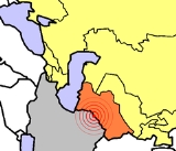
of the earthquake was located near the small village Gara-Gaudan, 25 kilometers southwest of Ashgabat. The earthquake caused extreme damage in Ashgabat and nearby villages, where almost all brick buildings collapsed, concrete structures were heavily damaged, and freight trains were derailed. Damage and casualties occurred in Darreh Gaz, Iran
. Surface rupture was observed northwest and southeast of Ashgabat. Media sources vary on the number of the casualties from 10,000 to 176,000. A news release on 9 December 1988 advised that the correct death toll was 110,000, equivalent to almost 10% of the Turkmen SSR's population at the time. A 2007 report by the State News Agency of Turkmenistan gives a total number of up to 176,000.
According to memoirs of survivors, the city infrastructure was badly damaged, with the exception of water pipes. Electricity was restored six days after the earthquake. The railway station began functioning on the third day.
Aid to victims, as well as restoration of basic needs and infrastructure, was provided by the Red Army.
This earthquake killed future Turkmen president Saparmurat Niyazov
's mother (his father having died during World War II
) and the rest of his family, leaving him an orphan.
Moment magnitude scale
The moment magnitude scale is used by seismologists to measure the size of earthquakes in terms of the energy released. The magnitude is based on the seismic moment of the earthquake, which is equal to the rigidity of the Earth multiplied by the average amount of slip on the fault and the size of...
, occurred on 6 October 1948 near Ashgabat, in the Turkmen Soviet Socialist Republic. The earthquake is considered to be the 6th deadliest earthquake in the history of humankind. Due to censorship
Censorship
thumb|[[Book burning]] following the [[1973 Chilean coup d'état|1973 coup]] that installed the [[Military government of Chile |Pinochet regime]] in Chile...
by the national government, the Ashgabat Earthquake was not much reported in USSR media. The scholars tend to agree that ban on publicity of the extent of earthquake casualties and damages did not allow the Soviet government to allocate enough financial resources to adequately respond to disaster. Admiral Ellis M. Zacharias
Ellis M. Zacharias
Ellis Mark Zacharias, Sr. was a Rear admiral and naval attaché to Japan, who served in World War I and World War II...
, former Deputy Chief of The Office Of Naval Intelligence, on his radio show Secret Missions (twice, on December 12, 1948, and on September 26, 1949), purported that the cause of the earthquake was the first Soviet atomic bomb test.
Details
The earthquake struck at 2:17 in the morning on 6 October 1948. The epicenterEpicenter
The epicenter or epicentre is the point on the Earth's surface that is directly above the hypocenter or focus, the point where an earthquake or underground explosion originates...
of the earthquake was located near the small village Gara-Gaudan, 25 kilometers southwest of Ashgabat. The earthquake caused extreme damage in Ashgabat and nearby villages, where almost all brick buildings collapsed, concrete structures were heavily damaged, and freight trains were derailed. Damage and casualties occurred in Darreh Gaz, Iran
Iran
Iran , officially the Islamic Republic of Iran , is a country in Southern and Western Asia. The name "Iran" has been in use natively since the Sassanian era and came into use internationally in 1935, before which the country was known to the Western world as Persia...
. Surface rupture was observed northwest and southeast of Ashgabat. Media sources vary on the number of the casualties from 10,000 to 176,000. A news release on 9 December 1988 advised that the correct death toll was 110,000, equivalent to almost 10% of the Turkmen SSR's population at the time. A 2007 report by the State News Agency of Turkmenistan gives a total number of up to 176,000.
According to memoirs of survivors, the city infrastructure was badly damaged, with the exception of water pipes. Electricity was restored six days after the earthquake. The railway station began functioning on the third day.
Aid to victims, as well as restoration of basic needs and infrastructure, was provided by the Red Army.
This earthquake killed future Turkmen president Saparmurat Niyazov
Saparmurat Niyazov
Saparmurat Atayevich Niyazov; , was a Turkmen politician who served as President of Turkmenistan from 2 November 1990 until his death in 2006...
's mother (his father having died during World War II
World War II
World War II, or the Second World War , was a global conflict lasting from 1939 to 1945, involving most of the world's nations—including all of the great powers—eventually forming two opposing military alliances: the Allies and the Axis...
) and the rest of his family, leaving him an orphan.
See also
- List of deadliest earthquakes