
1931 Hawke's Bay earthquake
Encyclopedia

New Zealand
New Zealand is an island country in the south-western Pacific Ocean comprising two main landmasses and numerous smaller islands. The country is situated some east of Australia across the Tasman Sea, and roughly south of the Pacific island nations of New Caledonia, Fiji, and Tonga...
at 10:47 am on Tuesday 3 February 1931, killing 256 and devastating the Hawke's Bay region. It remains New Zealand's deadliest natural disaster
Natural disaster
A natural disaster is the effect of a natural hazard . It leads to financial, environmental or human losses...
. Centred 15 km north of Napier
Napier, New Zealand
Napier is a New Zealand city with a seaport, located in Hawke's Bay on the eastern coast of the North Island. The population of Napier is about About 18 kilometres south of Napier is the inland city of Hastings. These two neighboring cities are often called "The Twin Cities" or "The Bay Cities"...
, it lasted for two and a half minutes and measured about 7.8 on the Richter scale
Richter magnitude scale
The expression Richter magnitude scale refers to a number of ways to assign a single number to quantify the energy contained in an earthquake....
(7.9 on the moment magnitude scale
Moment magnitude scale
The moment magnitude scale is used by seismologists to measure the size of earthquakes in terms of the energy released. The magnitude is based on the seismic moment of the earthquake, which is equal to the rigidity of the Earth multiplied by the average amount of slip on the fault and the size of...
). There were 525 aftershocks recorded in the following two weeks. The main shock could be felt in much of the southern half of the North Island
North Island
The North Island is one of the two main islands of New Zealand, separated from the much less populous South Island by Cook Strait. The island is in area, making it the world's 14th-largest island...
.
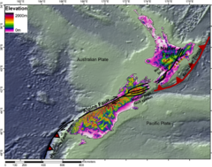
Tectonic setting
New Zealand lies along the boundary between the Indo-Australian PlateIndo-Australian Plate
The Indo-Australian Plate is a major tectonic plate that includes the continent of Australia and surrounding ocean, and extends northwest to include the Indian subcontinent and adjacent waters...
and Pacific Plate
Pacific Plate
The Pacific Plate is an oceanic tectonic plate that lies beneath the Pacific Ocean. At 103 million square kilometres, it is the largest tectonic plate....
s. In the South Island
South Island
The South Island is the larger of the two major islands of New Zealand, the other being the more populous North Island. It is bordered to the north by Cook Strait, to the west by the Tasman Sea, to the south and east by the Pacific Ocean...
most of the relative displacement between these plates is taken up along a single dextral (right lateral) strike-slip fault with a major reverse component, the Alpine Fault
Alpine Fault
The Alpine Fault is a geological fault, more specifically known as a right-lateral strike-slip fault, that runs almost the entire length of New Zealand's South Island. It forms a transform boundary between the Pacific Plate and the Indo-Australian Plate. Earthquakes along the fault, and the...
. In the North Island
North Island
The North Island is one of the two main islands of New Zealand, separated from the much less populous South Island by Cook Strait. The island is in area, making it the world's 14th-largest island...
the displacement is mainly taken up along the Hikurangi Subduction Zone, although the remaining dextral strike-slip component of the relative plate motion is accommodated by the North Island Fault System
North Island Fault System
The North Island Fault System or North Island Dextral Fault Belt is a set of southwest-northeast trending seismically-active faults in the North Island of New Zealand that carry most of the dextral strike-slip component of the oblique convergence of the Pacific Plate with the Australian Plate...
(NIFS).
The earthquake is thought to have occurred on one of the larger thrust
Thrust fault
A thrust fault is a type of fault, or break in the Earth's crust across which there has been relative movement, in which rocks of lower stratigraphic position are pushed up and over higher strata. They are often recognized because they place older rocks above younger...
faults within the accretionary wedge
Accretionary wedge
An accretionary wedge or accretionary prism is formed from sediments that are accreted onto the non-subducting tectonic plate at a convergent plate boundary...
, at between ca. 5 km depth and ca. 20–25 km depth (which is the approximate depth of subducted Pacific plate at that location)
Effects
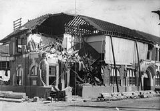
Nearly all buildings in the central areas of Napier and Hastings were levelled (The DominionThe Dominion Post (Wellington)
The Dominion Post is a metropolitan broadsheet newspaper published in Wellington, New Zealand, owned by the Australian Fairfax group, owners of The Age, Melbourne, and The Sydney Morning Herald.- Foundation :...
noted that "Napier as a town has been wiped off the map") and the death toll included 161 people in Napier
Napier, New Zealand
Napier is a New Zealand city with a seaport, located in Hawke's Bay on the eastern coast of the North Island. The population of Napier is about About 18 kilometres south of Napier is the inland city of Hastings. These two neighboring cities are often called "The Twin Cities" or "The Bay Cities"...
, 93 in Hastings
Hastings, New Zealand
The city of Hastings is a major urban settlement in the Hawke's Bay region of the North Island of New Zealand, and it is the largest settlement by population in Hawke's Bay. Hastings city is the administrative centre of the Hastings District...
, and two in Wairoa
Wairoa
Wairoa is a town in New Zealand's North Island. It is the northernmost town in the Hawke's Bay region, and is located on the northern shore of Hawke Bay at the mouth of the Wairoa River and to the west of Mahia Peninsula...
. Thousands more were injured, with over 400 hospitalised.
The local landscape changed dramatically, with the coastal areas around Napier being lifted by around two metres. The most noticeable land change was the uplifting of some 40 km² of sea-bed to become dry land. This included Ahuriri Lagoon, which was lifted more than 2.7 metres and resulted in draining 2230 hectares of the lagoon. Today, this area is the location of Hawkes Bay Airport
Napier Airport
Hawke's Bay Airport is Hawke's Bay's main commercial airport serving domestic flights to the main centres of Auckland, Wellington and Christchurch as well as smaller centres such as Gisborne, Tauranga, Hamilton and Palmerston North...
, housing and industrial developments and farmland.
Within minutes fires broke out in chemist shops in Hastings Street. The fire brigade almost had the first fire under control when the second broke out in a shop at the back of the Masonic Hotel. The hotel was quickly engulfed in flames. The wind at this point also picked up strength and began blowing from the east, pushing the fires back over the city. With water mains broken the brigade was unable to save many buildings. Pumping water from Clive Square they were able to stop the fires spreading south. Only a few buildings in the central Napier area survived. Some withstood the earthquake only to be gutted by fire. Trapped people had to be left to burn as people were unable to free them in time. By Wednesday morning the main fires were out but the ruins still smouldered for several days.
In Hastings, the fires were quickly brought under control.
The death toll might have been much higher had the Royal Navy
Royal Navy
The Royal Navy is the naval warfare service branch of the British Armed Forces. Founded in the 16th century, it is the oldest service branch and is known as the Senior Service...
ship HMS Veronica
HMS Veronica
HMS Veronica was an Acacia-class sloop of the Royal Navy, built by Dunlop Bremner & Company, Port Glasgow. She was laid down in January 1915, launched on 27 May 1915 and completed in August 1915...
not been in port at the time. Within minutes of the shock the Veronica had sent radio messages asking for help. The sailors joined survivors to fight the fires, rescue trapped people and help give them medical treatment. The Veronicas radio was used to transmit news of the disaster to the outside world and to seek assistance. The crew from two cargo ships, the Northumberland and Taranaki, also joined the rescue works, while two cruisers, HMS Diomede and HMS Dunedin, were dispatched from Auckland that afternoon with food, tents, medicine, blankets, and a team of doctors and nurses. The cruisers sailed at high speed overnight, arrived on 4 February and provided valuable assistance in all areas until their departure on 11 February.
A group of prisoners working at Bluff Hill in Napier had four of their number buried in a landslip by the quake. The remaining prisoners dug them out, but two had been killed. The prisoners re-assembled without any attempt to escape and were locked up in the Napier Jail. In Taradale, Mission Estate missionaries accommodation block was built and opened in February 1931, the next day the Hawke's Bay earthquake struck, causing serious damage to the entire Mission. Two priests and seven students were killed when the stone chapel was destroyed. In Havelock North
Havelock North, New Zealand
Havelock North is a suburb in Hastings, New Zealand, in the North Island's Hawke's Bay region. It ranked as a borough for many years until the 1989 reorganisation of local government saw it merged into the new Hastings District....
, St Luke's church was damaged (but not destroyed) just before a wedding was due to take place. The couple got married later in the day, but outdoors.
Within four days of the quake, cinemas around New Zealand offered news specials about the disaster.
Another casualty of the earthquake was the Napier trams. The tracks were twisted by the earthquake, and were never restored.
New Zealand's first commercial air disaster occurred six days after the quake, when a Dominion Airlines Desoutter monoplane crashed near Wairoa. The small airline had been making three return trips a day between Hastings and Gisborne, carrying passengers and supplies. All three on board were killed.
The Napier Daily Telegraph had recently celebrated its diamond jubilee with an article describing Napier as "the Nice
Nice
Nice is the fifth most populous city in France, after Paris, Marseille, Lyon and Toulouse, with a population of 348,721 within its administrative limits on a land area of . The urban area of Nice extends beyond the administrative city limits with a population of more than 955,000 on an area of...
of the Pacific". The newspaper office was destroyed by the quake. The Hawke's Bay Herald offices in Hastings were also destroyed.
Rebuilding
The earthquake prompted a thorough review of New Zealand building codes, which were found to be totally inadequate. Many buildings built during the 1930s and 1940s are heavily reinforced, although more recent research has developed other strengthening techniques. To this day there are few buildings in Hawke's Bay taller than five stories, and as most of Napier's rebuilding took place in the 1930s when Art DecoArt Deco
Art deco , or deco, is an eclectic artistic and design style that began in Paris in the 1920s and flourished internationally throughout the 1930s, into the World War II era. The style influenced all areas of design, including architecture and interior design, industrial design, fashion and...
was fashionable, Napier architecture is regarded today as being one of the finest collections of Art Deco in the world. Hastings was also rebuilt with many Art Deco and Spanish Mission style buildings.
On the tenth anniversary of the earthquake, the New Zealand Listener
New Zealand Listener
The New Zealand Listener is a New Zealand magazine. First published in 1939 and edited by Oliver Duff and the Monte Holcroft it originally had a monopoly on the publication of of upcoming television and radio programmes. In the 1980s it lost its monopoly on the publication of upcoming television...
reported that Napier had risen from the ashes like a phoenix. "Napier today is a far lovelier city than it was before", it quoted the 1931 principal of Napier Girls' High School
Napier Girls' High School
Napier Girls High School is a state secondary school on Clyde Road, Napier, New Zealand. It has a current school roll of over 900.- Houses :There are house competitions in place with the four houses being:* Blue* Red* Green* Gold...
as saying.