

1833 Sumatra earthquake
Encyclopedia
Moment magnitude scale
The moment magnitude scale is used by seismologists to measure the size of earthquakes in terms of the energy released. The magnitude is based on the seismic moment of the earthquake, which is equal to the rigidity of the Earth multiplied by the average amount of slip on the fault and the size of...
in the range Mw= 8.8–9.2. It caused a large tsunami
Tsunami
A tsunami is a series of water waves caused by the displacement of a large volume of a body of water, typically an ocean or a large lake...
that flooded the southwestern coast of the island. There are no reliable records of the loss of life, with the casualties being described only as 'numerous'. The magnitude of this event has been estimated using records of uplift taken from coral
Coral
Corals are marine animals in class Anthozoa of phylum Cnidaria typically living in compact colonies of many identical individual "polyps". The group includes the important reef builders that inhabit tropical oceans and secrete calcium carbonate to form a hard skeleton.A coral "head" is a colony of...
microatoll
Microatoll
A microatoll is a discoid colony of coral, dead on the top but living around the perimeter. Growth is mainly lateral, as upward growth is limited by exposure to air. Microatolls may be up to in diameter. They are named for their resemblance to island atolls formed during the subsidence of...
s.
Background
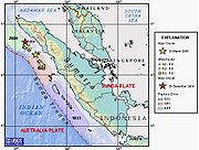
The island of Sumatra lies on the convergent plate boundaryConvergent boundary
In plate tectonics, a convergent boundary, also known as a destructive plate boundary , is an actively deforming region where two tectonic plates or fragments of lithosphere move toward one another and collide...
between the Indo-Australian Plate
Indo-Australian Plate
The Indo-Australian Plate is a major tectonic plate that includes the continent of Australia and surrounding ocean, and extends northwest to include the Indian subcontinent and adjacent waters...
and the Eurasian Plate
Eurasian Plate
The Eurasian Plate is a tectonic plate which includes most of the continent of Eurasia , with the notable exceptions of the Indian subcontinent, the Arabian subcontinent, and the area east of the Chersky Range in East Siberia...
. The convergence between these plates is highly oblique near Sumatra, with the displacement being accommodated by near pure dip-slip faulting along the subduction zone, known as the Sunda megathrust
Sunda megathrust
The Sunda megathrust is a fault that extends approximately 5,500 km from Myanmar in the north, running along the southwestern side of Sumatra, to the south of Java and Bali before terminating near Australia...
, and near pure strike-slip faulting along the Great Sumatran fault
Great Sumatran fault
The Indonesian island of Sumatra is located in a highly seismic area of the world. In addition to the subduction zone and the associated Sunda Arc off the west coast of the island, Sumatra also has a large strike-slip fault, the so-called Great Sumatran Fault, running the entire length of the island...
. The major slip events on the subduction zone interface are typically of megathrust type. Historically, great or giant megathrust earthquakes have been recorded in 1797
1797 Sumatra earthquake
The 1797 Sumatra earthquake was the first in a series of great earthquakes that ruptured part of the Sumatran segment of the Sunda megathrust. It caused a damaging tsunami that was particularly severe near Padang, where a 150-200 ton English ship was driven 1 km inland up the Arau...
, 1833, 1861
1861 Sumatra earthquake
The 1861 Sumatra earthquake occurred on February 16, 1861. It was the last in a sequences of earthquakes that ruptured adjacent parts of the Sumatran segment of the Sunda megathrust. It caused a devastating tsunami which led to several thousand fatalities. The earthquake was felt as far away as the...
, 2004
2004 Indian Ocean earthquake
The 2004 Indian Ocean earthquake was an undersea megathrust earthquake that occurred at 00:58:53 UTC on Sunday, December 26, 2004, with an epicentre off the west coast of Sumatra, Indonesia. The quake itself is known by the scientific community as the Sumatra-Andaman earthquake...
, 2005
2005 Sumatra earthquake
The 2005 Sumatra earthquake, referred to as the Nias Earthquake by the scientific community, was a major earthquake on 28 March 2005, located off the west coast of northern Sumatra, Indonesia. Approximately 1300 people were killed by the earthquake, mostly on the island of Nias...
and 2007, most of them being associated with devastating tsunamis. Smaller (but still large) megathrust events have also occurred in the small gaps between the areas that slip during the larger events, in 1935
1935 Sumatra earthquake
The 1935 Sumatra earthquake occurred at 02:35 UTC on 28 December 1935. It had a magnitude of Mw = 7.7 and a maximum felt intensity of VIII on the mercalli intensity scale. It triggered a minor tsunami.-Tectonic setting:...
, 1984
1984 Northern Sumatra earthquake
The 1984 Northern Sumatra earthquake occurred on November 17, 1984 at 06:49 UTC. The epicenter was located off the coast of Sumatra, near the island of Nias. It was an Mw 7.2 earthquake. Building damage was reported in Nias island. This earthquake could be strongly felt in parts of Northern...
, 2000
2000 Sumatra earthquake
The 2000 Sumatra earthquake struck at 23:30 local time on June 4, 2000 off the coast of southern Sumatra, Indonesia with a magnitude of 7.9 Mw. The United States Geological Survey reported 103 fatalities, in addition to 2,174 injured people...
and 2002
2002 Sumatra earthquake
The 2002 Sumatra earthquake occurred at 01:26 UTC on 2 November. It had a magnitude of 7.3 on the moment magnitude scale with an epicenter just north of Simeulue island and caused three deaths...
.
Damage
There is only sparse information available regarding the extent of damage associated with either the earthquake or the subsequent tsunami. However, the tsunami was clearly devastating along the southwest coast of Sumatra from PariamanPariaman
Pariaman is a coastal city in West Sumatra, Indonesia. Pariaman has 72,089 inhabitants , an area of and a coastline. "Pariaman" means "safe area".-History:...
to Bengkulu
Bengkulu
Bengkulu is a province of Indonesia. It is on the southwest coast of the island of Sumatra, and borders the provinces of West Sumatra, Jambi, South Sumatra and Lampung. The capital and largest city is Bengkulu city. It was formerly the site of a British garrison, which they called Bencoolen...
. There is also a lone report of significant damage in the Seychelles
Seychelles
Seychelles , officially the Republic of Seychelles , is an island country spanning an archipelago of 115 islands in the Indian Ocean, some east of mainland Africa, northeast of the island of Madagascar....
.
Earthquake
The earthquake shaking lasted 5 minutes in Bengkulu and 3 minutes in Padang, combined with the severity this suggests a very large source rupture. The rupture extent and the magnitude of this earthquake has been determined using the effect of relative sea level changes on coral microatolls from a group of small islands along the outer arc ridge that runs parallel the coast of Sumatra, the Mentawai islandsMentawai Islands
The Mentawai Islands are a chain of about seventy islands and islets off the western coast of Sumatra in Indonesia. Siberut is the largest of the islands. The other major islands are Sipura, North Pagai and South Pagai . The islands lie approximately 150 km off the Sumatran coast, across the...
. These microatolls, named for their resemblance to island atoll
Atoll
An atoll is a coral island that encircles a lagoon partially or completely.- Usage :The word atoll comes from the Dhivehi word atholhu OED...
s, can be used to provide a record of sea level change. Microatolls form because the coral head cannot grow up beyond low tide level (known as highest level of survival or HLS) as exposure leads to death. The morphology of the microatolls directly reflects changes in HLS. The presence of annual growth banding combined with the Uranium-thorium dating
Uranium-thorium dating
Uranium-thorium dating, also called thorium-230 dating, uranium-series disequilibrium dating or uranium-series dating, is a radiometric dating technique commonly used to determine the age of calcium carbonate materials such as speleothem or coral...
method allows morphological changes to be dated, with an uncertainty of only a few years to a few decades.