

Ásbyrgi
Encyclopedia
Iceland
Iceland , described as the Republic of Iceland, is a Nordic and European island country in the North Atlantic Ocean, on the Mid-Atlantic Ridge. Iceland also refers to the main island of the country, which contains almost all the population and almost all the land area. The country has a population...
, about two hours' drive to the east from Akureyri
Akureyri
Akureyri is a town in northern Iceland. It is Iceland's second largest urban area and fourth largest municipality ....
. The horseshoe
Horseshoe
A horseshoe, is a fabricated product, normally made of metal, although sometimes made partially or wholly of modern synthetic materials, designed to protect a horse's hoof from wear and tear. Shoes are attached on the palmar surface of the hooves, usually nailed through the insensitive hoof wall...
-shaped depression is part of the Jökulsárgljúfur National Park
Jökulsárgljúfur National Park
Jökulsárgljúfur National Park was a national park, situated in the north of Iceland around the river Jökulsá á Fjöllum. It lay to the north of the Dettifoss waterfall. On 7 June 2008, it became a part of the larger Vatnajökull National Park....
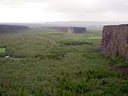
and measures approximately 3.5 km in length and 1.1 km across. For more than half of its length, the canyon is divided through the middle by a distinctive rock formation 25 meters high called Eyjan ("the Island"), from which hikers may enjoy spectacular views.
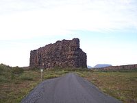
The canyon's steep sides are formed by cliffs up to 100 metres in height. Down in the canyon, visitors walk through a woodland of birch and willow. Between 1947 and 1977, a number of foreign tree species were introduced, including fir, larch and pine. The small lake Botnstjörn is home to a variety of waterfowl species.
Ásbyrgi was most likely formed by catastrophic glacial flooding
Jökulhlaup
A jökulhlaup is a glacial outburst flood. It is an Icelandic term that has been adopted by the English language. It originally referred to the well-known subglacial outburst floods from Vatnajökull, Iceland which are triggered by geothermal heating and occasionally by a volcanic subglacial...
of the river Jökulsá á Fjöllum
Jökulsá á Fjöllum
Jökulsá á Fjöllum is the second longest river of Iceland . Its source is the Vatnajökull glacier. It flows into the Arctic Sea. Jökulsá á Fjöllum streams over the waterfalls Selfoss and Dettifoss, the second of which is the most powerful waterfall in Europe, and through the canyon at...
after the last Ice Age, first 8-10,000 years ago, and then again some 3,000 years ago. The river has since changed its course and now runs about 2 km to the east. The legend explains the unusual shape of the canyon differently. Nicknamed Sleipnir's footprint, it is said that the canyon was formed when Odin
Odin
Odin is a major god in Norse mythology and the ruler of Asgard. Homologous with the Anglo-Saxon "Wōden" and the Old High German "Wotan", the name is descended from Proto-Germanic "*Wodanaz" or "*Wōđanaz"....
's eight-legged horse, Sleipnir
Sleipnir
In Norse mythology, Sleipnir is an eight-legged horse. Sleipnir is attested in the Poetic Edda, compiled in the 13th century from earlier traditional sources, and the Prose Edda, written in the 13th century by Snorri Sturluson...
, touched one of its feet to the ground here. Legend also relates that the canyon is the capital city of the "hidden people" (huldufólk
Huldufólk
Huldufólk are elves in Icelandic folklore. Building projects in Iceland are sometimes altered to prevent damaging the rocks where they are believed to live. According to these Icelandic folk beliefs, one should never throw stones because of the possibility of hitting the huldufólk...
), who live in cracks within the surrounding cliffs.
External links
- Photos
- Walking tour
- Pictures from Ásbyrgi www.islandsmyndir.is