

aussieResearcher
Where was: "Park Gate Deep Pit" near Rawmarsh (1820s to 1924); and its 'worker housing'? Traditionally coal miners lived close to their work and in tight knit communities.
There are some confusing reference as to "Deep Pit" (http://www.rotherhamunofficial.co.uk/history/tradeandindustry/coalinfo/coalinforawmarsh.html). The timeline is unclear. I think there was in fact a "New Deep" pit as well.
My 4xgreat grandfather George was a coal miner in "New Parkgate", Greasbrough, in 1841 (Census). The Children's Employment Commission, 1842 found his son George,12, working in the "Park Gate Deep Pit" 2 1/2 years. He would "help fill and hurry". They had horses and "seven or eight hurriers". Sounds like a full-on, deep mine with several shafts, including ventilation shafts / furnace; and galleries, not just open cast mining.
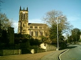
According to other boys interviewed, there was a church somewhere, in the locality, and a school.
A part of traditional 'Parkgate' was included in Greasbrough civil parish. Fitzwilliam's Arms just snuck into Greasbrough Parish. There are baptisms recorded for "New Parkgate", but on the Rawmarsh Parish Register; then after 1844 they stop! 'New Parkgate' locality is sometimes referred to (http://www.rotherhamunofficial.co.uk/history/tradeandindustry/coalinfo/coalinforawmarsh.html).
"Drakes Roadbook" of 1840 refers to the "New Park Gate Colliery, belonging to Earl Fitzwilliam". The old Wentworth Estate records (WWM/V/6 1754-1854), under "Miscellaneous Colliery & Railroad Vouchers", however, refer to a "Park Gate Colliery, 1835, 1839,1845,1847, 1849, 1850". As to location, I have but a theory.
There are some confusing reference as to "Deep Pit" (http://www.rotherhamunofficial.co.uk/history/tradeandindustry/coalinfo/coalinforawmarsh.html). The timeline is unclear. I think there was in fact a "New Deep" pit as well.
My 4xgreat grandfather George was a coal miner in "New Parkgate", Greasbrough, in 1841 (Census). The Children's Employment Commission, 1842 found his son George,12, working in the "Park Gate Deep Pit" 2 1/2 years. He would "help fill and hurry". They had horses and "seven or eight hurriers". Sounds like a full-on, deep mine with several shafts, including ventilation shafts / furnace; and galleries, not just open cast mining.
According to other boys interviewed, there was a church somewhere, in the locality, and a school.
A part of traditional 'Parkgate' was included in Greasbrough civil parish. Fitzwilliam's Arms just snuck into Greasbrough Parish. There are baptisms recorded for "New Parkgate", but on the Rawmarsh Parish Register; then after 1844 they stop! 'New Parkgate' locality is sometimes referred to (http://www.rotherhamunofficial.co.uk/history/tradeandindustry/coalinfo/coalinforawmarsh.html).
"Drakes Roadbook" of 1840 refers to the "New Park Gate Colliery, belonging to Earl Fitzwilliam". The old Wentworth Estate records (WWM/V/6 1754-1854), under "Miscellaneous Colliery & Railroad Vouchers", however, refer to a "Park Gate Colliery, 1835, 1839,1845,1847, 1849, 1850". As to location, I have but a theory.