

Pašková
Encyclopedia
Village
A village is a clustered human settlement or community, larger than a hamlet with the population ranging from a few hundred to a few thousand , Though often located in rural areas, the term urban village is also applied to certain urban neighbourhoods, such as the West Village in Manhattan, New...
and municipality
Municipality
A municipality is essentially an urban administrative division having corporate status and usually powers of self-government. It can also be used to mean the governing body of a municipality. A municipality is a general-purpose administrative subdivision, as opposed to a special-purpose district...
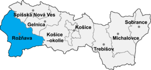
in the Rožňava District
Rožnava District
Rožňava District is a district in the Košice Region of eastern Slovakia.Until 1918, the district was mostly part of the Hungarian county of Gömör és Kishont, apart from the area in the south-east around the municipalities of Silická Jablonica, Hrušov, Jablonov nad Turňou and Hrhov which formed...
in the Košice Region
Košice Region
The Košice Region is one of the eight Slovak administrative regions. It consists of 11 districts .-Geography:It is located in the southern part of eastern Slovakia and covers an area of 6,752 km²...
of middle-eastern Slovakia
Slovakia
The Slovak Republic is a landlocked state in Central Europe. It has a population of over five million and an area of about . Slovakia is bordered by the Czech Republic and Austria to the west, Poland to the north, Ukraine to the east and Hungary to the south...
.
The Hungarian name is Páskaháza.
Geography
The village lies at an altitudeAltitude
Altitude or height is defined based on the context in which it is used . As a general definition, altitude is a distance measurement, usually in the vertical or "up" direction, between a reference datum and a point or object. The reference datum also often varies according to the context...
of 237 metres and covers an area of 6.007 km².
The village is situated in a valley oriented from north to south. The eastern mountain chain has its local peak near the village called Nagyhegy, or "Big Hill."
A river flows through it, called Sajo (in Hungarian).
Population
It has a population of about 290 people. Most of the village has always been Hungarian speaking. In the second half of the 20th century the portion of gypsy population gradually outgrew in number the rest.A large part of population born after the World War II left the village and moved to towns and cities. Only few remained to work in agriculture. Currently, most of the population is either white and retired, or gypsy and unemployed.
Culture
The most important building (apart from the pub) is the church.The village has a public library.
Economy
The village's economy has always been agricultural. With the rise of communism in the second half of the 20th century, individual farmers were more or less forcibly consolidated in a local collective farm (similar to Soviet kolchoz). The economic situation of the now private collective farm is uncertain.Some agricultural activity is done by private farmers.
There is a small local shop with consumer credit activities and a small local pub , but the pub has been closed down recently, however, because of violence.
External links
- http://www.statistics.sk/mosmis/eng/run.html