

Municipalities of Michoacán
Encyclopedia
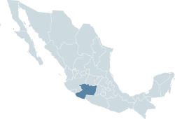
Mexico
The United Mexican States , commonly known as Mexico , is a federal constitutional republic in North America. It is bordered on the north by the United States; on the south and west by the Pacific Ocean; on the southeast by Guatemala, Belize, and the Caribbean Sea; and on the east by the Gulf of...
state
States of Mexico
The United Mexican States is a federal republic formed by 32 federal entities .According to the Constitution of 1917, the states of the federation are free and sovereign. Each state has their own congress and constitution, while the Federal District has only limited autonomy with a local Congress...
of Michoacán
Michoacán
Michoacán officially Estado Libre y Soberano de Michoacán de Ocampo is one of the 31 states which, with the Federal District, comprise the 32 Federal Entities of Mexico. It is divided in 113 municipalities and its capital city is Morelia...
is made up of 113 municipios (municipalities
Municipality
A municipality is essentially an urban administrative division having corporate status and usually powers of self-government. It can also be used to mean the governing body of a municipality. A municipality is a general-purpose administrative subdivision, as opposed to a special-purpose district...
):
|- style="text-align:center; background:#d8edff;"
!INEGI
National Institute of Statistics, Geography, and Data Processing
The National Institute of Statistic and Geography is an autonomous agency of the Mexican Government dedicated to coordinate the National System of Statistical and Geographical Information of the country...
code!! Municipality !! Municipal Seat
|-
|001 || Acuitzio
Acuitzío
Acuitzio is a municipality located in the central region of the Mexican state of Michoacán. The municipality has an area of 180.13 square kilometres and is bordered to the north and northwest by the municipality of Morelia, to the east by Madero, to south by Tacámbaro, and to the southwest by...
|| Acuitzio del Canje
|-
|002 || Aguililla || Aguililla
Aguililla
Aguililla is a city in the Mexican state of Michoacán. It serves as the municipal seat for the surrounding municipality of the same name. The city has a population of roughly 25,000.-External links:* * * , from the Stanford Daily Online...
|-
|003 || Álvaro Obregón || Álvaro Obregón
Álvaro Obregón, Michoacán
Álvaro Obregón is located in the center zone of the Mexican state of Michoacán.This town limits with the state of Guanajuato to the north, with Querendaro and Indaparapeo to the east, with Charo to the south, with Tarimbaro to the west and with Cuitzeo to the northwest. It is also home to Morelia's...
|-
|004 || Angamacutiro || Angamacutiro de la Unión
|-
|005 || Angangueo
Angangueo
Angangueo is a town and municipality located in far eastern Michoacán state in central Mexico noted for its history of mining and its location in the Monarch Butterfly Biosphere Reserve. It is located in high rugged forested mountains, with the town in a small canyon...
|| Mineral de Angangueo
|-
|006 || Apatzingán
Apatzingán
Apatzingán is a city and its surrounding municipality. It's located in the hot Tierra Caliente valley, in the west-central part of the Mexican state of Michoacán. The city is the fourth-largest in Michoacán , with a 2005 census population of 93,180 persons...
|| Apatzingán de la Constitución
|-
|007 || Aporo || Aporo
|-
|008 || Aquila
Aquila, Michoacán
Aquila is a town in the northwest part of the Mexican state of Michoacán. It is 23 mi/43 km southeast of Tecoman. Its population was 1,915 in 2002. It is located at Latitude: 18°35'N Longitude: 103°31'W and at elevation 989 ft/510 m. It has harsh terrain. Agriculture consists of small...
|| Aquila
Aquila, Michoacán
Aquila is a town in the northwest part of the Mexican state of Michoacán. It is 23 mi/43 km southeast of Tecoman. Its population was 1,915 in 2002. It is located at Latitude: 18°35'N Longitude: 103°31'W and at elevation 989 ft/510 m. It has harsh terrain. Agriculture consists of small...
|-
|009 || Ario
Ario, Michoacán
Ario is a municipality located in the Mexican state of Michoacán. The municipality has an area of 694.60 square kilometres and is bordered to the north by Salvador Escalante, to the east by Tacámbaro and Turicato, to the south by La Huacana, to the west by Nuevo Urecho, and to the northwest by...
|| Ario de Rosales
|-
|010 || Arteaga || Arteaga
Arteaga, Michoacán
Arteaga is a municipality located in the southern region of the Mexican state of Michoacán. The municipality has an area of 3,454.71 square kilometres and is bordered to the north by the municipality of La Huacana, to the east by Churumuco and the state of Guerrero, to the south by Lázaro...
|-
|011 || Briseñas || Briseñas de Matamoros
|-
|012 || Buenavista || Buenavista Tomatlán
|-
|013 || Caracuaro || Caracuaro de Morelos
|-
|014 || Charapan || Charapan
Charapan
Charapan is a municipality located in the north-western part of the Mexican state of Michoacán. The municipality has an area of 233.16 square kilometres and is bordered to the north by the municipalities of Tangancícuaro and Chilchota, to the east by Paracho, to the south by Uruapan, and to the...
|-
|015 || Charo || Charo
Charo, Michoacán
Charo is a municipality located in the Mexican state of Michoacán. The municipality has an area of 322.50 square kilometres and is bordered to the north by Tarímbaro and Álvaro Obregón, to the east by Indaparapeo, to the south by Tzitzío, and to the west and southwest by Morelia...
|-
|016 || Chavinda || Chavinda
Chavinda
Chavinda, which means "place of four winds" in the Purepecha language, is a small town in the Mexican state of Michoacán. It is located at an elevation of 5150 ft, about three hours' drive from Morelia and Guadalajara. The estimated population is about 15,000 people.Chavinda is the municipal seat...
|-
|017 || Cherán || Cherán
Cherán
The municipio of Cherán is located in the Mexican state of Michoacán, which is situated in the central western portion of the Republic of Mexico and extends to the Pacific Shore...
|-
|018 || Chilchota || Chilchota
|-
|019 || Chinicuila
Chinicuila
Chinicuila is a municipality located in the southwestern region of the Mexican state of Michoacán. The municipality has an area of 928.64 square kilometres and is bordered to the north by the state of Jalisco, to the east by Coalcomán, to the south by Aquila, and to the west by Coahuayana and the...
|| Villa Victoria
Villa Victoria
Villa Victoria is a town and municipality in Mexico State in Mexico. The municipality covers an area of 424.03 km².As of 2005, the municipality had a total population of 77,819....
|-
|020 || Chucándiro || Chucándiro
|-
|021 || Churintzio || Churintzio
|-
|022 || Churumuco || Churumuco de Morelos
|-
|023 || Coahuayana
Coahuayana
Coahuayana is a municipality located in the southwest region of the Mexican state of Michoacán. The municipality has an area of 362.34 square kilometres and is bordered to the north by the municipality of Chinicuila, to the south by Aquila and the Pacific Ocean, and to the west and northwest by...
|| Coahuayana de Hidalgo
|-
|024 || Coalcomán de Vázquez Pallares || Coalcomán de Vázquez Pallares
Coalcomán de Vázquez Pallares
Coalcomán de Vázquez Pallares is a municipality located in the southwest region of the Mexican state of Michoacán. The municipality has an area of 2,881.57 square kilometres and is bordered to the north by the state of Jalisco and the municipality of Tepalcatepec, to the east by Arteaga and...
|-
|025 || Coeneo || Coeneo de la Libertad
Coeneo de la Libertad
Coeneo de la Libertad is a town, the seat of the Coeneo municipality, located in the north central area of the Mexican state of Michoacán. The name Coeneo means "Lugar de Pájaros" .-History:...
|-
|026 || Cojumatlán de Régules || Cojumatlán de Régules
|-
|027 || Contepec || Contepec
|-
|028 || Copándaro
Copándaro
Copándaro is a municipality located in the Mexican state of Michoacán. The municipality has an area of 173.52 square kilometres and is bordered to the north by Huandacareo and Cuitzeo, to the east and south by Tarímbaro, and to the west by Chucándiro. The municipality had a population of 8,131...
|| Copándaro de Galeana
|-
|029 || Cotija
Cotija, Michoacán
Cotija is a municipality located in the Mexican state of Michoacán. The municipality has an area of 504.05 square kilometres , and is bordered to the north by Jiquilpan and Villamar, to the east by Tocumbo, and to south by the state of Jalisco. The municipality had a population of 18,207...
|| Cotija de la Paz
|-
|030 || Cuitzeo || Cuitzeo del Porvenir
|-
|031 || Ecuandureo || Ecuandureo
|-
|032 || Epitácio Huerta || Epitácio Huerta
|-
|033 || Erongaricuaro || Erongaricuaro
Erongarícuaro
Erongarícuaro, which means "Place of waiting" in the Purepecha language, is a town in the Mexican state of Michoacán. It is located about an hour and a half drive to Morelia or Uruapan and just 20 minutes from the famous colonial town of Pátzcuaro...
|-
|034 || Gabriel Zamora
Gabriel Zamora
Gabriel Zamora is a municipality in the center of the Mexican state of Michoacán. The municipality has an area of 426.98 square kilometres and is bordered to the north by the municipalities of Nuevo Parangaricutiro, Uruapan and Taretan, to the east by Nuevo Urecho, to the south by Múgica, and to...
|| Lombardía
|-
|035 || Hidalgo || Ciudad Hidalgo
|-
|036 || La Huacana || La Huacana
La Huacana
La Huacana is a municipality in the south-central part of the Mexican state of Michoacán. The municipality has an area of 1,952.60 square kilometres and is bordered to the north by the municipalities of Nuevo Urecho and Ario, to the east by Turicato, to the south by Churumuco and Arteaga, and to...
|-
|037 || Huandacareo || Huandacareo
Huandacareo
Huandacareo is an archaeological zone located about 60 kilometers north of the city of Morelia, in the state of Michoacán.The site was constructed on an elevated plateau overlooking the Cuitzeo lake, some 2.46 kilometers from its north western shores and about two kilometers from the center of...
|-
|038 || Huaniqueo || Huaniqueo de Morales
|-
|039 || Huetamo
Huetamo
Huetamo is a municipality in the southeastern corner of the Mexican state of Michoacán, in a region known as "Tierra Caliente" . Of indigenous Purepecha Indian origin, the word "Huetamo" means "four chiefs" or "four came". Fr...
|| Huetamo de Núñez
|-
|040 || Huiramba || Huiramba
|-
|041 || Indaparapeo || Indaparapeo
|-
|042 || Irimbo || Irimbo
|-
|043 || Ixtlán || Ixtlán de los Hervores
Ixtlán de los Hervores
Ixtlán de los Hervores, also known as Ixtlán, is a city in the Mexican state of Michoacán. It islocated 29 kilometres from Jiquilpan by state highway 16 and 26 kilometres to the northeast of the city of Zamora by way of highway 35....
|-
|044 || Jacona
Jacona, Michoacán
Jacona de Plancarte is a city, county seat of Jacona in the state of Michoacán. Located in the northwest of the state, on the northern slope of the Sierra de Patamban, part of the Volcanic Belt, at 1,600 meters altitude. It was founded by Fray Sebastián de Trasierra in 1555, although they are...
|| Jacona de Plancarte
|-
|045 || Jiménez || Villa Jiménez
|-
|046 || Jiquilpan
Jiquilpan
Jiquilpan is a municipality in the Mexican state of Michoacán...
|| Jiquilpan de Juárez
Jiquilpan de Juárez
Jiquilpan de Juárez is a town of about 15,000 residents in northwest Michoacán, Mexico, near the border with the states of Colima and Jalisco. It is the seat of the municipio of Jiquilpan and the birthplace of President Lázaro Cárdenas . The city is home to the Centro de Estudios de la Revolución...
|-
|047 || José Sixto Verduzco || Pastor Ortiz
Pastor Ortiz
The city of Pastor Ortiz is in the north of the Mexican state of Michoacán.It is located at .The population is 5,000.The name of the city means "place in straw hill" in the Purépecha language....
|-
|048 || Juárez || Benito Juárez
|-
|049 || Jungapeo
Jungapeo
Jungapeo is a municipality in the eastern part of the Mexican state of Michoacán. The municipality has an area of 265.98 square kilometres and is bordered to the north by the municipality of Tuxpan, to the east by Juárez and Zitácuaro, to the south by Tuzantla, and to the west by Hildago...
|| Jungapeo de Juárez
|-
|050 || Lagunillas || Lagunillas (town)
Lagunillas, Michoacán
Lagunillas is a town in the Mexican state of Michoacán. It serves as the municipal seat for the surrounding municipality of Lagunillas-History:...
|-
|051 || La Piedad || La Piedad
La Piedad
La Piedad de Cavadas is a city and its surrounding municipality located at in the north-west of the Mexican state of Michoacán, bordering Jalisco and Guanajuato. The original colonial name was San Sebastián. It is bordered by the town of Santa Ana Pacueco, Guanajuato. Both towns straddle the...
|-
|052 || Lázaro Cárdenas || Lázaro Cárdenas
Lázaro Cárdenas, Michoacán
Lázaro Cárdenas is a port city that with its surrounding municipality is located in the southern part of the Mexican state of Michoacán. It was formerly known as Los Llanitos, but changed its name as a tribute to Lázaro Cárdenas del Río, a Michoacán-born politician who was president of Mexico from...
|-
|053 || Los Reyes
Los Reyes, Michoacán
Los Reyes is a municipality in the western part of the Mexican state of Michoacán. The municipality has an area of 480.09 square kilometres and is bordered to the north by the municipality of Tangancícuaro, to the east by Charapan, to the southeast by Uruapan, to the south by Peribán, to the...
|| Los Reyes de Salgado
|-
|054 || Madero || Villa Madero
|-
|055 || Maravatío
Maravatío
Maravatío is a municipality in the Mexican state of Michoacán, representing 1.17% of its land area, or 691.55 km2.- Etymology :The modern word Maravatío comes from the P'urhépecha word Marhabatio, meaning a precious place or thing....
|| Maravatío de Ocampo
|-
|056 || Marcos
Marcos Castellanos
Marcos Castellanos is a municipio in the Mexican state of Michoacán near the southern shore of Lake Chapala. The municipal seat is the city of San José de Gracia....
|| San José de Gracia
San José de Gracia, Michoacán
San José de Gracia is a parish in Michoacán, Mexico. It is not mentioned in any history of Mexico, neither is it referred to in any of the annals of the state of Michoacán. The area of San José de Gracia is approximately 231 square kilometers...
|-
|057 || Morelia || Morelia
Morelia
Morelia is a city and municipality in the north central part of the state of Michoacán in central Mexico. The city is in the Guayangareo Valley and is the capital of the state. The main pre-Hispanic cultures here were the P'urhépecha and the Matlatzinca, but no major cities were founded in the...
|-
|058 || Morelos || Villa Morelos
|-
|059 || Múgica || Nueva Italia
Nueva Italia, Michoacán
Nueva Italia is a city in the state of Michoacán, is located in the so-called Tierra Caliente Michoacana.- History :The town was founded in the year 1909 by Italian Dante Cusi to become the leading producer of cotton rice melon and maize of all of Mexico because it introduced these arid and...
|-
|060 || Nahuatzén || Nahuatzén
|-
|061 || Nocupétaro || Nocupétaro de Morelos
|-
|062 || Nuevo Parangaricutiro || Nuevo San Juan Parangaricutiro
|-
|063 || Nuevo Urecho || Nuevo Urecho
Nuevo Urecho
Nuevo Urecho is a municipality located in the center of the Mexican state of Michoacán. The municipality has an area of 330.66 square kilometres and is bordered to the north by the municipality of Taretan, to the east by Ario, to the south by La Huacana, and to the west by Gabriel Zamora...
|-
|064 || Numarán || Numarán
|-
|065 || Ocampo || Ocampo
|-
|066 || Pajacuarán || Pajacuarán
|-
|067 || Panindicuaro || Panindicuaro
|-
|068 || Paracho || Paracho de Verduzco
|-
|069 || Parácuaro || Parácuaro
Parácuaro
Parácuaro is a municipality of Michoacán, Mexico. It is a Chichimeca word for "Place where has it own sticks for one roof".-History:In the PreHispanic era, Parácuaro is thought to have been inhabited by Nahuas and later conquered by the chief Tarasco Utucuma.During the colonial period, the Spanish...
|-
|070 || Pátzcuaro || Pátzcuaro
Pátzcuaro
Pátzcuaro is a large town and municipality located in the state of Michoacán. The town was founded sometime in the 1320s, at first becoming the capital of the Tarascan state and later its ceremonial center...
|-
|071 || Penjamillo
Penjamillo
Penjamillo de Degollado is a place in the Mexican state of Michoacán that was founded in 1576 by Viceroy Carlos de Medici....
|| Penjamillo de Degollado
|-
|072 || Peribán
Peribán
Peribán is a municipality located in the western part of the Mexican state of Michoacán. The municipality has an area of 331.87 square kilometres and is bordered to the north by the municipality of Los Reyes, to the east by Uruapan, to the southeast by Tancítaro, to the south by Buenavista, and to...
|| Peribán de Ramos
|-
|073 || Purépero || Purépero de Echaíz
|-
|074 || Puruándiro || Puruándiro
Puruándiro
The city of Puruándiro is in the north of the Mexican state of Michoacán.It is located at .The population is 90,000.The name of the city means "place of hot water" in the Purépecha language. Puruandiro is one of the most outstanding cities in the state of Michoacan....
|-
|075 || Queréndaro || Queréndaro
|-
|076 || Quiroga
Quiroga, Michoacán
Quiroga is a municipality in the Mexican state of Michoacán. The municipal seat of Quiroga is also called Quiroga.-Geographic location:The municipality of Quiroga is located at the north of the State, at coordinates 19 º 40 'N latitude and 101 ° 32' west. At an altitude of 2080 meters above sea level...
|| Quiroga
Quiroga, Michoacán
Quiroga is a municipality in the Mexican state of Michoacán. The municipal seat of Quiroga is also called Quiroga.-Geographic location:The municipality of Quiroga is located at the north of the State, at coordinates 19 º 40 'N latitude and 101 ° 32' west. At an altitude of 2080 meters above sea level...
|-
|077 || Sahuayo
Sahuayo
Sahuayo is a city in the state of Michoacán, in western México, near the southern shore of Lake Chapala. It serves as the municipal seat for the surrounding municipality of the same name...
|| Sahuayo de Morelos
|-
|078 || Salvador Escalante || Santa Clara del Cobre
Santa Clara del Cobre
Santa Clara del Cobre is a town and municipality located in the center of the state of Michoacán, Mexico, 18 km from Pátzcuaro and 79 km from the state capital of Morelia...
|-
|079 || San Lucas
San Lucas, Michoacán
San Lucas is a municipality located in the Mexican state of Michoacán. The municipality has an area of 474.41 square kilometres and is bordered to the north by the municipality of Tiquicheo, to the east and south by the state of Guerrero, and to the west by Huetamo. The municipality had a...
|| San Lucas
San Lucas, Michoacán
San Lucas is a municipality located in the Mexican state of Michoacán. The municipality has an area of 474.41 square kilometres and is bordered to the north by the municipality of Tiquicheo, to the east and south by the state of Guerrero, and to the west by Huetamo. The municipality had a...
|-
|080 || Santa Ana Maya || Santa Ana Maya
Santa Ana Maya
Santa Ana Maya is a small municipality in the Mexican state of Michoacán, bordering on the state of Guanajuato and Lake Cuitzeo. Several small towns pertain to it: Huacao, La Lobera, El Cuervo, La Ladera, Potzundareo, San Rafael, El Toronjo, La Mesa Rica, La Colonia, and the largest is the town of...
|-
|081 || Senguío || Senguío
|-
|082 || Susupuato
Susupuato
Susupuato is a municipality in the eastern part of the Mexican state of Michoacán. The municipality has an area of 273.33 square kilometres and is bordered to the north by the municipality of Juárez, to the east and south by the state of México, and to the west by Tuzantla...
|| Susupuato de Guerrero
|-
|083 || Tacámbaro || Tacámbaro de Codallos
|-
|084 || Tancítaro || Tancítaro
Tancítaro
Tancítaro is a municipality in the western part of the Mexican state of Michoacán. The municipality has an area of 717.65 square kilometres and is bordered to the north by the municipalities of Peribán and Uruapan, to the east by Nuevo Parangaricutiro, to southeast by Parácuaro, to the south by...
|-
|085 || Tangamandapio
Tangamandapio
Tangamandapio is a municipality located in the northwest part of the Mexican state of Michoacán, WSW of Zamora, Michoacán, 165 km from the state capital of Morelia. The geographic coordinates are: 19° 57' North latitude and 102° 26' West longitude....
|| Santiago Tangamandapio
|-
|086 || Tangancícuaro
Tangancícuaro
Tangancícuaro is a municipio in the Mexican state of Michoacán.The municipal seat is the city of Tangancícuaro de Arista. Tangancícuaro is at an altitude of 1,700 meters above sea level, with an area of 387.95 km²...
|| Tangancícuaro de Arista
|-
|087 || Tanhuato || Tanhuato de Guerrero
|-
|088 || Taretan || Taretan
Taretan
Taretan is a municipality located in the central part of the Mexican state of Michoacán. The municipality has an area of 185.23 square kilometres and is bordered to the north by the municipality of Ziracuaretiro, to the east by Salvador Escalante and Ario, to the south by Gabriel Zamora and Nuevo...
|-
|089 || Tarímbaro || Tarímbaro
Tarímbaro
Tarímbaro is a municipality in the Mexican state of Michoacán which Valtazar Gaona is the major of. The municipality has an area of 258.57 square kilometres and is bordered to the north by Copándaro, Meson Nuevo and Cuitzeo, to the east by Álvaro Obregón, to the south by Morelia and Charo, and to...
|-
|090 || Tepalcatepec || Tepalcatepec
Tepalcatepec
Tepalcatepec is a town in Michoacán, Mexico, located north of Canollita.It is the endemic environment of Michoacan Club-tail iguana...
|-
|091 || Tingambato || Tingambato
Tingambato
Tingambato is a municipality in the north-central part of the Mexican state of Michoacán. Its municipal seat is the city of the same name. The municipality has an area of 188.77 square kilometres and is bordered by the north by the municipalites of Nahuatzén and Erongarícuaro, to the east by...
|-
|092 || Tingüindín || Tingüindín
Tinguindin
Tingüindín is a municipality in the Mexican state of Michoacán. The municipality has an area of 174.24 square kilometres and is bordered to the north by the municipalities of Villamar, Tangamandapio and Tangancícuaro, to the east by Los Reyes, and to the south and west by Tocumbo...
|-
|093 || Tiquicheo de Nicolas Romero || Tiquicheo
Tiquicheo
Tiquicheo de Nicolás Romero is a municipality located in the Mexican state of Michoacán. The municipality has an area of 1,429.65 square kilometres and is bordered to the north by the municipality of Tzitzio, to the east by Tuzantla and the state of México, to the south by San Lucas, Huetamo and...
|-
|094 || Tlalpujahua
Tlalpujahua
Tlalpujahua is a town and municipality located in the far northeast of the state of Michoacán in central Mexico. It is a former mining town, home of the Dos Estrellas Mine, which was the leading producer of gold in the early 20th century...
|| Tlalpujahua de Rayón
|-
|095 || Tlazazalca || Tlazazalca
Tlazazalca
Tlazazalcais a small town, and municipal seat, in the Mexican state of Michoacán. This small town is older than many of the biggest cities in Mexico, including Guadalajara.-List of Mayors :1940 José Zamora Gil1941 J. Salud Díaz Navarro...
|-
|096 || Tocumbo || Tocumbo
Tocumbo
Tocumbo is a municipality in the Mexican state of Michoacán. The municipality has an area of 506.85 square kilometres and is bordered to the north by Tingüindín, to the east by Los Reyes, to south by the state of Jalisco, and to the west by Cotija. The municipality had a population of 8,820...
|-
|097 || Tumbiscatío
Tumbiscatío
Tumbiscatío is a municipality in the southwest region of the Mexican state of Michoacán. The municipality has an area of 2,069.48 square kilometres and is bordered to the north by the municipalities of Apatzingán and La Huacana, to the east and south by Arteaga, to the southwest by Coalcomán de...
|| Tumbiscatío de Ruiz
|-
|098 || Turicato
Turicato
Turicato is a municipality in the state of Michoacán, Mexico. Turicato comes from the word "turicata" that refers to a parasite that lives mainly in areas where there is cattle....
|| Turicato
Turicato
Turicato is a municipality in the state of Michoacán, Mexico. Turicato comes from the word "turicata" that refers to a parasite that lives mainly in areas where there is cattle....
|-
|099 || Tuxpan || Tuxpan
Tuxpan, Michoacán
Tuxpan Michoacán es un pequeño pueblo en medio de Zitácuaro y Ciudad Hidalgo en el estado mexicano de Michoacán. Tuxpan se encuentra 118 kilometros de Morelia....
|-
|100 || Tuzantla || Tuzantla
Tuzantla
Tuzantla is a municipality in the eastern part of the Mexican state of Michoacán. The municipality has an area of 1,018.49 square kilometres and is bordered to the north by the municipalities of Jungapeo and Hidalgo, to the east by Juárez and Susupuato, to the south by Tiquicheo and the state of...
|-
|101 || Tzintzuntzan || Tzintzuntzan, Michoacán
Tzintzuntzan, Michoacán
Tzintzuntzán is a town and municipality located in the north of Michoacán state, 53 km from the capital of Morelia and 17.5 km from Pátzcuaro, located on the northeast shore of Lake Pátzcuaro. It is best known as the former capital of the Tarascan state until it was conquered by the...
|-
|102 || Tzitzío || Tzitzío
|-
|103 || Uruapan || Uruapan
Uruapan
Uruapan is a city and municipality in the west-central part of the Mexican state of Michoacán. The city is the municipal seat of the municipality...
|-
|104 || Venustiano Carranza || Venustiano Carranza
Venustiano Carranza, Michoacán
Venustiano Carranza is a small city located in the northern part of the Mexican state of Michoacán, in the region of the Chapala Lake. The city is still better known for its former pre-Mexican revolution name San Pedro Caro, which derives from the town's patron saint and the last name of its...
|-
|105 || Villamar || Villamar
|-
|106 || Vista Hermosa || Vista Hermosa de Negrete
|-
|107 || Yurécuaro
Yurécuaro (municipality)
Yurécuaro is a municipality located in the Mexican state of Michoacan. The municipal seat is the town of Yurécuaro....
|| Yurécuaro
Yurécuaro
Yurécuaro is a town and a municipality in the region of the Chapala cienega at the north-west in the Mexican state of Michoacán.Yurécuaro comes from the purepecha iorekuarhu means "River side" or "Place of growing" "lugar junto al rio" o "Lugar de crecientes".It is located at northwest of the...
|-
|108 || Zacapú || Zacapú
Zacapú
Zacapu is a city and its surrounding municipality in the Nahuatzen mountains of Michoacán, Mexico. the city had a population of 51,386 in the 2005 census and the municipality 70,636. The municipality has an area of 455.96 km² .- Georaphy :The municipality has an area of 455.96 km. It is...
|-
|109 || Zamora
Zamora, Michoacán
Zamora de Hidalgo, is a city in the Mexican state of Michoacán. The 2010 census population was 141,627. making it the third largest city in the state. The city is the municipal seat of Zamora Municipality, which has an area of 330.97 km² and includes many other smaller communities, the largest of...
|| Zamora de Hidalgo
|-
|110 || Zináparo || Zináparo
|-
|111 || Zinapécuaro || Zinapécuaro de Figueroa
|-
|112 || Ziracuaretiro || Ziracuaretiro
|-
|113 || Zitácuaro
Zitácuaro
Zitácuaro is a city in the Mexican state of Michoacán. The city is the administrative centre for the surrounding municipality of the same name, which lies at the extreme eastern side of Michoacán and borders on the adjacent state of México...
|| Heroica Zitácuaro
|}